


Servicios Personalizados
Articulo
 Inglés (pdf)
 Articulo en XML
 Referencias del artículo
Indicadores

Links relacionados
-
 Citado por Google
 -
 Similares en Google
Compartir

 Permalink
South African Journal of Science
versión On-line ISSN 1996-7489
versión impresa ISSN 0038-2353
S. Afr. j. sci. vol.118 no.9-10 Pretoria sep./oct. 2022
http://dx.doi.org/10.17159/sajs.2022/12302
RESEARCH ARTICLE
An open access geospatial database for the sub-Antarctic Prince Edward Islands
Elizabeth M. RudolphI; David W. HeddingII; P.J. Nico de BruynIII; Werner NelIV
IAfromontane Research Unit, Department of Geography, University of the Free State, Bloemfontein, South Africa
IIDepartment of Geography, University of South Africa, Johannesburg, South Africa
IIIMammal Research Institute, Department of Zoology and Entomology, University of Pretoria, Pretoria, South Africa
IVDepartment of Geography and Environmental Science, University of Fort Hare, Alice, South Africa
ABSTRACT
Researchers of projects at the sub-Antarctic Prince Edward Islands are increasingly considering geospatial data as an essential component in answering scientific questions. A need exists for high-resolution geospatial data in both multi- and transdisciplinary research to better analyse fine-scale biotic-abiotic interactions of the Islands' landscape and ecosystems within the context of climate change and the impacts of invasive species. However, much of the geospatial data that currently exist have limitations in spatial coverage and/or resolution, are outdated, or are not readily available. To address these issues, we present an online geospatial database for the Prince Edward Islands (both islands) produced from a high-resolution digital surface model and satellite imagery. This database contains vector files, raster data sets, and maps of topographical and hydrological parameters. It is freely available to download from Figshare - an open access data repository. We encourage the South African polar science community to make use of similar platforms for improved data sharing practices.
SIGNIFICANCE: •A topographical and hydrological geospatial database - produced from a 1 m x 1 m digital surface model of the Prince Edward Islands - is provided. •These fine-scale geospatial data allow for a more comprehensive assessment of biotic-abiotic interactions at an island scale. •Also included are locality maps specifying place names and established long-term marine mammal monitoring beaches and coastal zones for improved cross-referencing. •The dataset is downloadable from an open access data repository and intended to promote open science and data sharing practices
Keywords: Prince Edward Island, Marion Island, geospatial database, open access, data sharing
Introduction
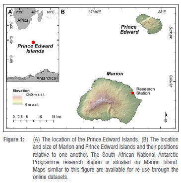
The sub-Antarctic Prince Edward Islands (47°S 38°E) - consisting of Prince Edward Island and Marion Island - are sentinels for terrestrial and marine research in the southern Indian Ocean (Figure 1).1 Located just north of the present-day Antarctic Polar Front and dominated by a hyper-maritime climate, the Islands provide a unique opportunity to study ecosystem responses to climate change.2-7 The research projects conducted at the Prince Edward Islands cover a range of botanical, geological, geomorphological, and biological studies.8,9 On the larger Marion Island, scientific research has been continuous for the last five decades, whereas on Prince Edward Island, access has been restricted to a single contingent of 10 people every four years10 (Figure 1). Terrestrial science, therefore, occurs predominantly on Marion Island while at Prince Edward Island it is limited in scope with most progress in botanical and ornithological studies.9 Geospatial information of Marion Island's topography has aided scientific investigations by not only providing the backdrop for site selection and planning of sampling strategies but also interpreting and modelling landscape and ecosystem evolution.11-14 Since the introduction of handheld Global Positioning Systems (GPS) in early 2000s, terrestrial multi- and transdisciplinary research on Marion Island has increasingly started to include assessment of fine-scale interactions within the landscape to understand ecosystem responses to past and present climate change, as well as the impacts of invasive species.15-18 Individual-based population studies focusing on various animal species have, by necessity, also been structured around specific geographical localities at the Islands to aid in experimental design.19 Not only do scientific endeavours depend on accurate geospatial information20, but conservation efforts, such as the planned mouse eradication programme on Marion Island21, require precise geospatial data to support the planning phase of (if successful) the world's largest eradication programme of mice from an island. However, much of the geospatial information for the Prince Edward Islands was previously only available in hardcopy format22,23 or, when such data have become available in digital format24, they have typically had a limited spatial coverage and/or resolution, particularly for Marion Island's west coast25. Generally, such geospatial data are shared informally among the scientists who work on the Prince Edward Islands or are reproduced ad hoc from existing publications. Yet, the circulating data are rarely curated or updated, or are sometimes lost entirely as researchers retire or move on to other research sites. Some of the geospatial data needs have been addressed by the production of data on the Islands' geology25, but fine-scale topographical and hydrological data are still outstanding. Furthermore, the naming process of the Prince Edward Islands' features remains unfinished.26 Since the first attempt to register Prince Edward Islands place names with the South African Geographical Names Council (Act 118 of 1998) in 200127, only a select few features (e.g. Umkhombe, Mascarin and Resolution Peaks) have thus far been approved26. Most of Prince Edward Islands' place names are still considered 'provisional'28 and are practically absent from the gazetteer of South African geographical names26,29. Nonetheless, these names are widely used in scientific spheres9 and official policy documents10. However, these names are used piecemeal in subject-specific or region-specific works and there is, therefore, a need for a complete list of place names for the Prince Edward Islands, whether officially recognised, provisionally accepted, or colloquial, as these are currently not readily available in the public domain.
Data sharing issues are not unique to the South African National Antarctic Programme (SANAP) science community. Globally, the focus on data sharing practices or 'open science' is increasing30,31 and has already transpired with specific African32,33 and South(ern) African perspectives. The push from government (through the South African Spatial Data Infrastructure Act, 54 of 2003), funding agencies, publishers, and institutions and for improved data availability33, have encouraged sharing practices by several scientific fields, amongst others, ecology34,35, geomatics36, and soil science37. Therefore, a geospatial database for both of the Prince Edward Islands is provided here, which includes topographical data (e.g. contour lines, aspect, slope, and hillshade raster), and hydrological data (e.g. streams and lakes) that were produced from a 1 m x 1 m digital surface model (DSM). In addition, topographical and locality maps of both Prince Edward and Marion Islands are provided in downloadable PDF format. We augment these contributions with marine mammal research-linked coastline codes/names that have been in long-term use for experimental design, and have consequently been adopted by the larger scientific community working at the Islands. Lastly, we provide a collated list of all the place names in use on Prince Edward and Marion Islands. The geospatial database, maps and the record of place names are available to download from Figshare (https://figshare.com/), an open access data repository.
Methods and results
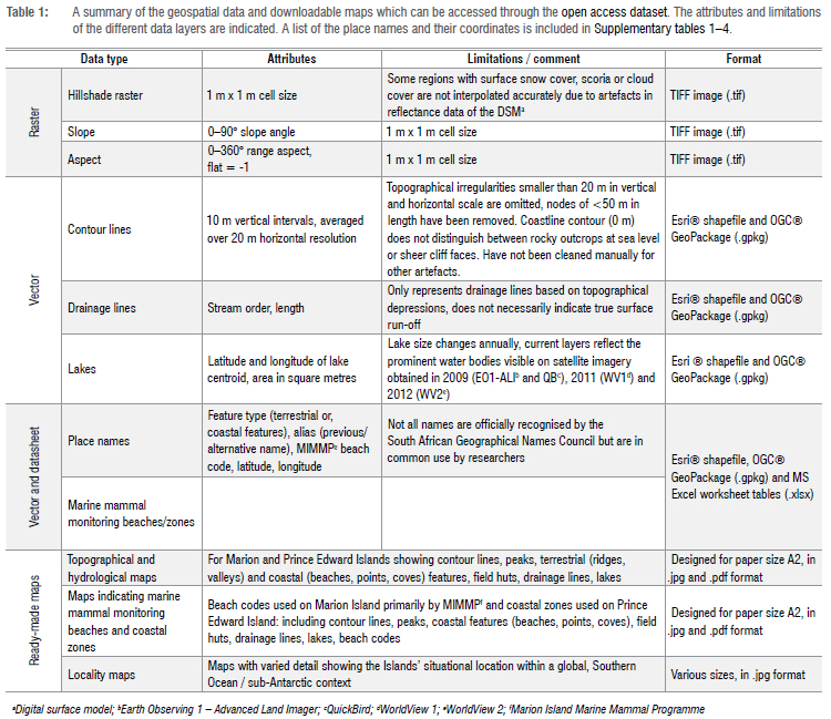
All the geospatial data were generated in Esri® ArcGIS® Desktop 10.6 where the 'WGS 84 datum' and 'Transverse Mercator projection' with longitude 37°E as the central meridian (CM37E) were selected (Figure 2). The mapping process for both Prince Edward and Marion Islands was based on a DSM with a 1 m x 1 m cell size resolution and 0.7 m vertical accuracy as the primary data source (Figure 2A). This DSM was produced by the Chief Directorate: National Geospatial Information of the South African Department of Agriculture, Land Reform and Rural Development and completed in 2017 photogrammetrically using stereo Pléiades imagery and accurate ground control points captured in 2016. All the topographical data were generated directly from the DSM. A hillshade raster was generated from the DSM using the 'hillshade' tool (Figure 2D). Slope (in degrees) and aspect were calculated using ArcGIS® 'Slope' and 'Aspect' tools, respectively (Figure 2B and 2C). Contour lines were produced by first smoothing the DSM with the 'Focal Statistics' tool (statistic type = mean) and using a 10-m vertical and 20-m horizontal cell-size neighbourhood, following the proposed methods of Price38. The 'Contour' tool was used to generate 10-m contours from the smoothed DSM raster and the final layer was cleaned by deleting all contours below sea level and contour line segments less than 50 m in length, to overcome the potential interference of artefacts (Figure 2B and 2E). Drainage lines were generated using the Esri® 'Hydrology' toolset's 'Fill' (z-limit=unspecified), 'Flow direction' (method=D8) and 'Flow accumulation' functions, following the procedures of Jenson and Domingue39. A flow accumulation threshold of 50 000 was used to determine the final drainage density by using the 'con' (conditional) tool. This threshold was considered sufficient to capture all the drainage lines previously mapped for Marion Island28, whereas a higher threshold would have produced excessive detail. The stream order of each drainage line was determined according to Strahler's classification, using the 'stream order' tool. The output raster was converted to a polyline feature (drainage lines) and smoothed at 30 m using a PEAK smoothing algorithm of the 'smooth line' tool (Figure 2D). The stream order, as well as the names of well-known22,23,28 stream channels, are included in the attribute data of the final 'drainage line' dataset layer (Table 1).
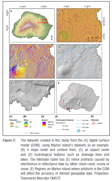
All these geospatial layers were clipped to coastline polygons, sourced from National Geospatial Information in 2019. Waterbodies or 'lakes' were mapped with the combined use of the hillshade raster and satellite imagery from Earth Observing 1 - Advanced Land Imager (EO1-ALI), QuickBird (QB), WorldView 1 (WV1) and WorldView 2 (WV2). The EO1-ALI has a 10-m cell-size resolution, was captured on 5 May 2009, and is orthorectified and georeferenced. The resolutions, production dates and limitations to the spatial coverage of the imagery sets from QB, WV1 and WV2 have already been covered by Rudolph et al.25,40 The QB, WV1 and WV2 imagery sets are not orthorectified but are rather only georeferenced. The outline of waterbodies were digitised at a scale of 1:1000 using the QB, WV1 and WV2 images, and then repositioned spatially using the EO1-ALI and hillshade raster as reference. Minor artefacts exist in the reflectance data of DSM in regions typically associated with cloud cover, scoria substrate or snow cover (Figure 2E). These interferences invariably effect the accuracy of the hillshade raster in, for example, Marion Island's Central Highland or on the west coastal plains where such surfaces are widespread and cloud cover is common (Figure 2F). In such cases, verification was done using available satellite imagery, existing maps22,23,28 and over two decades' of field observations8,19 which allowed for some lakes to be mapped for the first time. Alternative data validation is not possible at this time, as the reference data used in this study form the most complete, up-to-date and highest-resolution spatial dataset that is currently available. Still, geospatial data from these regions should be used with some caution. The attributes and use limitations of the final raster and vector layers are presented in Table 1. Vector data can be downloaded as Esri® shapefiles or OGC® GeoPackages (https://www.geopackage.org/). Complete metadata for each of the geospatial layers were captured according to the built-in ISO 19139 metadata standards of Esri® ArcCatalogTM and can be viewed as a stand-alone text file in the database.
A list of all the documented place names for the Prince Edward Islands was compiled by first referring to the original surveys41-43 and topographical maps22,23, and then updating the list from newer maps of Marion Island24,28 and lastly cross-checking this list with the Prince Edward Islands Management Plan10. Names not initially included in this compilation but that are in common use, specifically on Marion Island, were added to the list as an 'alias'. Where applicable, the older/previous name is also included under 'alias'. Coordinates are provided for the features, as determined using satellite imagery and the hillshade raster. For peaks, the coordinate indicates the highest point; for lakes, ridges or streams etc., a coordinate is given for a point within the feature. The collated place name lists for Marion and Prince Edward Islands are given in the online resource as geospatial datasets and as Supplementary tables 1 and 2, respectively. Lastly, a summary of marine mammal monitoring beaches and coastal zones visited by research programmes on Marion (e.g. Marion Island Marine Mammal Programme19) and Prince Edward Islands, and their code identifiers are included in the supplementary tables, the geospatial database and as annotated maps. Their long-term (over four decades) use has additionally benefitted use in consistency across different research programmes. A list of the names, coordinates, and their descriptions (where applicable) of marine mammal monitoring beaches at Marion Island and monitoring coastal zones at Prince Edward Island are provided in Supplementary tables 3 and 4, respectively. Sets of downloadable maps were constructed for both Marion and Prince Edward Islands, each one showing their respective topographical and hydrological features, and another depicting the location of marine mammal monitoring beaches and coastal zones. Previews of these maps can be seen in Figures 3-5 and their specifications can be seen in Table 1.
Location maps of the Island group were also created and have been made available for general use (Table 1). The final geospatial database and series of maps can be downloaded from Figshare (https://doi.org/10.6084/m9.figshare.19248626) as either vector or raster data, and in PDF or TIFF format (Table 1).
The maximum elevation and calculated surface area of the Prince Edward Islands have changed little since the first estimations were performed using the data collected during the island surveys of Langenegger and Verwoerd43. The first measurement of the elevation of the highest point on Marion Island was done by Captain Nares on the HMS Challenger in 1873.43 He determined the maximum elevation to be 1280 m above mean sea level (a.m.s.l.). Later, Langenegger and Verwoerd43 stated that the maximum elevation of Marion Island is 1230 m a.m.s.l., whereas Prince Edward Island is considerably lower at 672 m a.m.s.l. The map released for Marion Island in 200224 set the maximum contour line at 1240 m a.m.s.l. The most recent data for the Prince Edward Islands set the maximum elevation for Marion Island at 1248 m a.m.s.l. and 669 m a.m.s.l. for Prince Edward Island. However, these values should be verified in the field using a differential GPS. In addition, Verwoerd44 stated that the calculated surface areas of Marion Island and Prince Edward Island were 290 km2 and 44 km2, respectively. Using the first digital topographical data of Marion Island24, Meiklejohn and Smith45 calculated the projected surface area and actual surface area, using the raster-based method of Jenness46, as 290.33 km2 and 300.42 km2, respectively. Using the 'Add Surface Information' tool in ArcGIS® Desktop 10.6 on the 2019 DSM from National Geospatial Information, the 2D and 3D surface areas of Marion Island are calculated as 293.23 km2 and 346.65 km2, respectively. Using the same method, the 2D and 3D surface areas for Prince Edward Island are 45.09 km2 and 56.16 km2, respectively. Owing to the volcanic origin of the islands, their subaerial extent may change following any future volcanic eruptions and lava outflows.
Discussion
The geospatial database we have produced provides a valuable online resource for researchers working on the Prince Edward Islands. Prior to this database, geospatial data of the Prince Edward Islands existed either exclusively in hardcopy form22-24, had limited spatial resolution or were not readily available28. A digital dataset such as this, that provides fine-resolution geospatial data of both islands, will facilitate multi- and transdisciplinary research and allow for a more comprehensive assessment of biotic-abiotic interactions on an island scale, as well as improve modelling capabilities. More specifically, scientific investigations, which consider slope, aspect or elevation as key variables in their studies, can assess these relationships at a finer scale, using the topographical data provided here. For example, our understanding of the development of geomorphic features through aeolian47, soil frost4 and freeze-thaw7,48 or mass movement processes49, has been limited to point or site-specific datasets. Similarly, studies that focus on indigenous or invasive species can now investigate the potential control of topographical and/or hydrological factors on their distribution at a larger scale. This can be applied to, for example, burrow-nesting bird species13, microorganisms12,14 or plant communities. The effect of these topographic controls on variations in microclimate - such as wind stress16, temperature15 or precipitation6 - can also be explored at a higher resolution. Furthermore, long-term landscape development such as the islands' geological and geomorphological evolution44, deglaciation11 and island responses to climate change50,51 rely heavily on the knowledge of topographical controls, which can be readily achieved by (accurate) mapping25,40,50,52. In addition, as the dataset also incorporates Prince Edward Island at the same spatial resolution as that for Marion Island, it provides a unique opportunity to model and predict processes (e.g. geomorphic) or ecosystem interactions (e.g. vegetation assemblages, species population distribution) for the less frequented Prince Edward Island. The combined use of satellite imagery and the DSM allowed for the mapping of numerous waterbodies (lakes), including some along Marion Island's west and southwest coasts which have never been mapped before. In addition, a compilation of commonly used (official, provisional and colloquial) place names for both Prince Edward Islands and their feature descriptions are presented here. This record provides a much-needed summary or baseline of current 'local knowledge' and can facilitate the process of presenting these names, or alternatives, to the South African Geographical Names Council to ratify their use.
The availability of published data (or lack thereof), and particularly spatial data, is an issue not unique to the Prince Edward Islands' scientific community, but one that exists in general scientific practice.30,31,53 The South African government rightly recognises the need to encourage better data sharing practices through ratification of the South African Spatial Data Infrastructure Act (Act 54 of 2003). There are numerous advantages of data sharing33,53 and successful practices have been realised by several scientific disciplines34-36,54. The increasing demand for data sharing has sparked the emergence of numerous online data repositories such as Figshare55, Mendeley Data56,57, and Zenodo58. A Registry of Research Data Repositories (https://www.re3data.org/) makes it possible to find a digital repository to suit the specific needs of a research lab or project. Most of these repositories enable the user to publish data under a Creative Commons Attribution Licence, which allows for the data to be used, shared and/or adapted, as long as proper credit is given. In other words, authors retain copyright of the dataset. This practice is further supported by sharing platforms through assigning digital object identifiers (DOIs) to datasets, making them fully citable. Alternatively, dedicated universal data hosting infrastructures such as the Group on Earth Observations e.g. ArfiGEOSS59, and the South African Earth Observation Network (SAEON) also provide the opportunity for earth science data to be curated. Martínez-López et al.60 provide an overview of some of these platforms and we encourage scientists to explore and make use of these to improve access and curation of geospatial data. We further recommend that such practices form an integral part of the SANAP scientific community's mandate to foster open science.
Conclusion
Geospatial information provides the necessary geographical data for terrestrial scientific investigations. We provide here a topographical and hydrological geospatial database, produced from a 1 m x 1 m DSM of the Prince Edward Islands. These geospatial data will facilitate the consideration of finer-scale spatial variables in terrestrial scientific investigations at the Prince Edward Islands, and especially on Marion Island, from data collection to analysis and modelling phases of scientific investigations. Updated topographical maps of both islands are also available for download, along with locality maps, and lists inclusive of the Islands' place names and their localities are also provided. The geospatial database is downloadable from an open access data repository and the file formats ensure wide use across platforms. A more comprehensive integrated terrestrial and marine geospatial dataset is still needed to effectively monitor climate change impacts at the Prince Edward Islands and for the successful management of the Islands as a Marine Protected Area. For example, high-resolution bathymetry data of the ocean floor will facilitate an integration of terrestrial and oceanic studies to better understand the ocean-land interactions. We encourage research endeavours in the wider South African scientific community to support open science practices and make similar geospatial data readily available through open access data repositories, as has been done here.
Acknowledgements
We thank the South African National Antarctic Programme and the South African Department of Fisheries, Forestry and Environment for their logistical support, and the South African National Research Foundation for financial support (SANAP-NRF: 129235; 129228) throughout this study. We also thank the Office of the Chief Directorate: National Geospatial Information, National Geomatics Management Services Branch, Department of Agriculture, Land Reform and Rural Development for providing the data, without which we could not have produced this work. Lastly, we are grateful to two anonymous reviewers for their valuable inputs and also Adriaan van der Walt for his contribution towards the improvement of this paper.
Data availability
Datasets and maps used in this paper are available in the supplementary tables and as an open dataset to download from Figshare (https://doi.org/10.6084/m9.figshare.19248626). The dataset is licenced under a Creative Commons Attribution 4.0 International Licence.
Competing interests
We have no competing interests to declare.
Authors' contributions
E.M.R.: Conceptualisation; methodology; data analysis; validation; data curation; writing - the initial draft. D.W.H.: Conceptualisation; data analysis; validation; writing - revisions; project management; funding acquisition. P.J.N.d.B.: Validation; data curation; writing - revisions. W.N.: Conceptualisation; validation; writing - revisions; project leadership; funding acquisition. All approved the final version of the manuscript.
References
1.Ansorge IJ, Skelton P, Bekker A, De Bruyn PJN, Butterworth D, Cilliers P, et al. Exploring South Africa's southern frontier: A 20-year vision for polar research through the South African national antarctic programme. S Afr J Sci. 2017;113(5/6), Art. #a0205. https://doi.org/10.17159/sajs.2017/a0205 [ Links ]
2.Rouault M, Mélice JL, Reason CJC, Lutjeharms JRE. Climate variability at Marion Island, Southern Ocean, since 1960. J Geophys Res C Ocean. 2005;110(5):1-9. https://doi.org/10.1029/2004JC002492 [ Links ]
3.Smith VR. Climate change in the sub-Antarctic: An illustration from Marion Island. Clim Change. 2002;52:345-357. https://dx.doi.org/10.1023/A:1013718617277 [ Links ]
4.Nel W. A preliminary synoptic assessment of soil frost on Marion Island and the possible consequences of climate change in a maritime sub-Antarctic environment. Polar Res. 2012;31(1), Art. #17626. https://doi.org/10.3402/polar.v31i0.17626 [ Links ]
5.Le Roux PC. Climate and climate change. In: Chown SL, Froneman PW, editors. The Prince Edward Islands: Land-sea interactions in a changing ecosystem. Stellenbosch: SUN Press; 2008. p. 39-64. https://doi.org/10.18820/9781928314219/03 [ Links ]
6.Hedding DW, Greve M. Decreases in precipitation on sub-Antarctic Marion Island: Implications for ecological and geomorphological processes. Weather. 2018;73(6):203. https://doi.org/10.1002/wea.3245 [ Links ]
7.Boelhouwers J, Holness S, Sumner P. The maritime Subantarctic: A distinct periglacial environment. Geomorphology. 2003;52(1-2):39-55. https://doi.org/10.1016/s0169-555x(02)00247-7 [ Links ]
8.Nel W, Boelhouwers JC, Borg C-J, Cotrina JH, Hansen CD, Haussmann NS, et al. Earth science research on Marion Island (1996-2020): A synthesis and new findings. S Afr Geogr J. 2021;103(1):22-42. https://doi.org/10.1080/03736245.2020.1786445 [ Links ]
9.Chown SL, Froneman PW. The Prince Edward Islands: Land-sea interactions in a changing ecosystem. Stellenbosch: SUN Press; 2008. https://doi.org/10.18820/9781928357063/01 [ Links ]
10.DST-NRF Centre of Excellence for Invasion Biology. Prince Edward Islands Management Plan. Stellenbosch: DST-NRF Centre of Excellence for Invasion Biology; 2010. [ Links ]
11.Rudolph EM, Hedding DW, Fabel D, Hodgson DA, Gheorghiu DM, Shanks R, et al. Early glacial maximum and deglaciation at sub-Antarctic Marion Island from cosmogenic 36Cl exposure dating. Quat Sci Rev. 2020;231, Art. #106208. https://doi.org/10.1016/j.quascirev.2020.106208 [ Links ]
12.Chau JH, Born C, McGeoch MA, Bergstrom D, Shaw J, Terauds A, et al. The influence of landscape, climate and history on spatial genetic patterns in keystone plants (Azorella) on sub-Antarctic islands. Mol Ecol. 2019;28(14):3291-3305. https://doi.org/10.1111/mec.15147 [ Links ]
13.Dilley BJ, Hedding DW, Henry DAW, Rexer-Huber K, Parker GC, Schoombie S, et al. Clustered or dispersed: Testing the effect of sampling strategy to census burrow-nesting petrels with varied distributions at sub-Antarctic Marion Island. Antarct Sci. 2019;31(5):231-242. https://doi.org/10.1017/S0954102019000300 [ Links ]
14.Mortimer E, Jansen van Vuuren B, Meiklejohn KI, Chown SL. Phylogeography of a mite, Halozetes fulvus, reflects the landscape history of a young volcanic island in the sub-Antarctic. Biol J Linn Soc. 2012;105:131-145. https://doi.org/10.1111/j.1095-8312.2011.01770.x [ Links ]
15.Ripley BS, Edwardes A, Rossouw MW, Smith VR, Midgley GF. Invasive grasses of sub-Antarctic Marion Island respond to increasing temperatures at the expense of chilling tolerance. Ann Bot. 2020;125(5):765-773. https://doi.org/10.1093/aob/mcz156 [ Links ]
16.Momberg M, Hedding DW, Luoto M, Le Roux PC. Exposing wind stress as a driver of fine-scale variation in plant communities. J Ecol. 2021;109(5):2121-2136. https://doi.org/10.1111/1365-2745.13625 [ Links ]
17.Hugo-Coetzee EA, Le Roux PC. Distribution of microarthropods across altitude and aspect in the sub-antarctic: Climate change implications for an isolated Oceanic Island. Acarologia. 2018;58:43-60. https://doi.org/10.24349/acarologia/20184278 [ Links ]
18.Greve M, Mathakutha R, Steyn C, Chown SL. Terrestrial invasions on sub-Antarctic Marion and Prince Edwards Islands. Bothalia. 2017;47(2), Art. #2143. https://doi.org/10.4102/abc.v47i2.2143 [ Links ]
19.Bester MN, De Bruyn PJN, Oosthuizen WC, Tosh CA, McIntyre T, Reisinger RR, et al. The Marine Mammal Programme at the Prince Edward Islands: 38 years of research. Afr J Mar Sci. 2011;33(3):511-521. https://doi.org/10.2989/1814232X.2011.637356 [ Links ]
20.Hedding DW. Comment on "Clinopyroxene megacrysts from Marion Island, Antarctic Ocean: Evidence for a late stage shallow origin" (2019) by R. J. Roberts, K. D. Lehong, A. E. J. Botha, G. Costin, F. C. De Beer, W. J. Hoffman and C. J. Hetherington. Mineral Petrol. 2020;114(4):357-359. https://doi.org/10.1007/s00710-020-00713-z [ Links ]
21.Preston GR, Dilley BJ, Cooper J, Beaumont J, Chauke LF, Chown SL, et al. South Africa works towards eradicating introduced house mice from sub-Antarctic Marion Island: The largest island yet attempted for mice. In: Veitch C, Clout M, Martin A, Russell J, West C, editors. Island invasives: Scaling up to meet the challenge. Gland: IUCN; 2019. p. 40-46. https://portals.iucn.org/library/node/48358 [ Links ]
22.Langenegger O, Verwoerd WJ. Topographic map of Prince Edward Island. Pretoria: Geological Survey; 1968. [ Links ]
23.Langenegger O, Verwoerd WJ. Topographic map of Marion Island. Pretoria: Geological Survey; 1968. [ Links ]
24.Chief Directorate: Surveys and Mapping. Marion Island Provisional Map 1:25 000. Cape Town: Department of Environmental Affairs & Tourism; 2002. [ Links ]
25.Rudolph EM, Hedding DW, Nel W. The surface geology of the Prince Edward Islands: Refined spatial data and call for geoconservation. S Afr J Geol. 2021;124(3):627-638. https://doi.org/10.25131/sajg.124.0014 [ Links ]
26.Jenkins E. The naming of uninhabited islands: Jules Verne's The Mysterious Island and Marion Island. S Afr Geogr J. 2017;99:184-195. https://doi.org/10.1080/03736245.2016.1211032 [ Links ]
27.South African Geographical Names Council. Meeting Minutes. 2001; November. [ Links ]
28.National Geospatial Information. Marion Island Provisional Map 1:25 000. Cape Town: Department of Agriculture, Land Reform and Rural Development; 2005. [ Links ]
29.South African Geographical Names Council. Gazetteer of geographical names approved, 2000-2014. Pretoria: Department of Arts and Culture; 2014. [ Links ]
30.Chawinga WD, Zinn S. Global perspectives of research data sharing: A systematic literature review. Libr Inf Sci Res. 2019;41(2):109-122. https://doi.org/10.1016/j.lisr.2019.04.004 [ Links ]
31.Klump J. Long-term availability of geoscience data. In: Geoinformatics 2008 - data to knowledge. Reston, VA: US Geological Survey; 2008. p. 55-58. [ Links ]
32.Chiware ERT. Open research data in African academic and research libraries: A literature analysis. Libr Manag. 2020;41(6/7):383-399. https://doi.org/10.1108/LM-02-2020-0027 [ Links ]
33.Abebe R, Aruleba K, Birhane A, Kingsley S, Obaido G, Remy SL, et al. Narratives and counternarratives on data sharing in Africa. In: Conference on Fairness, Accountability, and Transparency (FAccT '21); 2021 Mar 3-10; virtual event. New York: Association for Computing Machinery; 2021. p. 329-341. https://doi.org/10.1145/3442188.3445897 [ Links ]
34.Rutherford MC, Mucina L, Powrie LW. The South African National Vegetation Database: History, development, applications, problems and future. S Afr J Sci. 2012;108(1/2), Art. #629. https://doi.org/10.4102/sajs.v108i1/2.629 [ Links ]
35.Coetzer W, Hamer M. Managing South African biodiversity research data: Meeting the challenges of rapidly developing information technology. S Afr J Sci. 2019;115(3/4), Art. #5482. https://doi.org/10.17159/sajs.2019/5482 [ Links ]
36.Sebake MD, Coetzee S. Results of three case studies for assessing motivators and barriers to address data sharing in South Africa. S Afr J Geomatics. 2012;1(1):32-43. [ Links ]
37.Paterson G, Turner D, Wiese L, Van Zijl G, Clarke C, Van Tol J. Spatial soil information in South Africa: Situational analysis, limitations and challenges. S Afr J Sci. 2015;111(5/6), Art. #2014-0178. https://doi.org/10.17159/sajs.2015/20140178 [ Links ]
38.Price M. Creating cool contours. Modeling glacial terrain with ArcGIS. ArcUser. 2006:48-51. Available from: https://www.esri.com/news/arcuser/0506/files/coolglaciers.pdf [ Links ]
39.Jenson SK, Domingue JO. Extracting topographic structure from digital elevation data for geographic information system analysis. Photogramm Eng Rem Sens. 1988;54(11):1593-1600. [ Links ]
40.Rudolph EM, Hedding DW, Nel W. The glacial geomorphology of sub-Antarctic Marion Island. J Maps. 2021;17(2):313-324. https://doi.org/10.1080/17445647.2021.1931970 [ Links ]
41.Verwoerd WJ. Kommentaar op 'n artikel onder die opskrif 'Place Names of Prince Edward Islands,' deur Sylvester L. Crozet [Commentary on an article entitled 'Place Names of Prince Edward Islands,' by Sylvester L. Crozet]. Antarct Bull. 1969;Jun:56. Afrikaans. [ Links ]
42.Crozet SL. Place names of the Prince Edward Islands. Antarct Bull. 1968:32-33. [ Links ]
43.Langenegger O, Verwoerd WJ. Topographic survey. In: Van Zinderen Bakker Sr. EM, Winterbottom JM, Dyer RA, editors. Marion and Prince Edward Islands: Report on the South African biological and geological research expedition 1965-1966. Cape Town: A.A. Balkema; 1971. p. 32-39. https://doi.org/10.1126/science.176.4035.662 [ Links ]
44.Verwoerd WJ. Geology. In: Van Zinderen Bakker Sr. EM, Winterbottom JM, Dyer RA, editors. Marion and Prince Edward Islands: Report on the South African biological and geological research expedition 1965-1966. Cape Town: A.A. Balkema; 1971. p. 40-62. https://doi.org/10.1126/science.176.4035.662 [ Links ]
45.Meiklejohn KI, Smith VR. Surface areas of altitudinal zones on sub-Antarctic Marion Island. Polar Biol. 2008;31(2):259-261. https://doi.org/10.1007/s00300-007-0389-5 [ Links ]
46.Jenness J. Calculating landscape surface area from digital elevation models. Wildl Soc Bull. 2004;32:829-839. https://doi.org/10.2193/0091-7648(2004)032[0829:CLSAFD]2.0.CO;2 [ Links ]
47.Hedding DW, Nel W, Anderson RL. Aeolian processes and landforms in the sub-Antarctic: Preliminary observations from Marion Island. Polar Res. 2015;34(1), Art. #26365. https://doi.org/10.3402/polar.v34.26365 [ Links ]
48.Hansen CD. On high-altitude and high-latitude diurnal frost environments [PhD thesis]. Grahamstown: Rhodes University; 2018. [ Links ]
49.Nel W, Holness S, Meiklejohn KI. Observations on rapid mass movement and screes on Sub-Antarctic Marion Island. S Afr J Sci. 2003;99(3/4):177-181. [ Links ]
50.Hedding DW. Spatial inventory of landforms in the recently exposed central highland of Sub-Antarctic Marion Island. S Afr Geogr J. 2008;90(1):11-21. https://doi.org/10.1080/03736245.2008.9725307 [ Links ]
51.Sumner PD, Meiklejohn KI, Boelhouwers JC, Hedding DW. Climate change melts Marion Island's snow and ice. S Afr J Sci. 2004;100(7):395-398. [ Links ]
52.Nel W. A spatial inventory of glacial, periglacial and rapid mass movement forms on part of Marion Island: Implications for Quaternary environmental change [MSc dissertation]. Pretoria: University of Pretoria; 2001. [ Links ]
53.Bangani S, Moyo M. Data sharing practices among researchers at South African universities. Data Sci J. 2019;18(1):1-14. https://doi.org/10.5334/dsj-2019-028 [ Links ]
54.Koopman MM, De Jager K. Archiving South African digital research data: How ready are we? S Afr J Sci. 2016;112(7/8), Art. #2015-0316. https://doi.org/10.17159/sajs.2016/20150316 [ Links ]
55.Thelwall M, Kousha K. Figshare: A universal repository for academic resource sharing? Online Inf Rev. 2016;40(3):333-346. https://doi.org/10.1108/OIR-06-2015-0190 [ Links ]
56.Bhoi NK, Centre B. Mendeley Data Repository as a platform for research data management. In: Rautaray B, Swain D, Swain C, editors. Marching beyond libraries: Managerial skills and technological competencies. Bhubaneswar: Overseas Press India Pvt. Ltd; 2018. p. 481-487. [ Links ]
57.Swab M. Mendeley data. J Can Heal Libr Assoc l'Association des bibliothèques la santé du Canada. 2016;37(3):121-123. https://doi.org/10.5596/c16-022 [ Links ]
58.Salvador S, Sicilia M, Garc E. Community curation in open dataset repositories : Insights from Zenodo. Procedia Comput Sci. 2017;106:54-60. https://doi.org/10.1016/j.procs.2017.03.009 [ Links ]
59.Group on Earth Observations (GEO). Strengthening the use of Earth Observations and bringing GEOSS to Africa. Geneva: GEO; 2017. Available from: https://www.earthobservations.org/documents/publications/201705_AfriGEOSS_brochure.pdf [ Links ]
60.Martínez-López JI, Barrón-González S, Martínez López A. Which are the tools available for scholars? A review of assisting software for authors during peer reviewing process. Publications. 2019;7(3):59. https://doi.org/doi:10.3390/publications7030059 [ Links ]
 Correspondence:
Elizabeth Rudolph
Email: rudolphem@ufs.ac.za
Received: 14 Sep. 2021
Revised: 13 Apr. 2022
Accepted: 04 May 2022
Published: 29 Sep. 2022
Editor: Jennifer Fitchett
Funding: South African National Research Foundation (SANAP-NRF: 129235; 129228)

