


Servicios Personalizados
Articulo
 Inglés (pdf)
 Articulo en XML
 Referencias del artículo
Indicadores

Links relacionados
-
 Citado por Google
 -
 Similares en Google
Compartir

 Permalink
South African Journal of Science
versión On-line ISSN 1996-7489
versión impresa ISSN 0038-2353
S. Afr. j. sci. vol.117 no.11-12 Pretoria nov./dic. 2021
http://dx.doi.org/10.17159/sajs.2021/10511
RESEARCH ARTICLE
Developing an environmental research platform in the Karoo at the Square Kilometre Array
Helga van der MerweI, II; Suzanne J. MiltonI, III; W. Richard J. DeanI, III; Tim G. O'ConnorI, IV; Joh R. HenschelI, V
ISouth African Environmental Observation Network (SAEON), Kimberley, South Africa
IIPlant Conservation Unit, Department of Biological Sciences, University of Cape Town, Cape Town, South Africa
IIIPercy FitzPatrick Institute of African Ornithology, Department of Biological Sciences, University of Cape Town, Cape Town, South Africa
IVSchool of Animal, Plant and Environmental Sciences, University of the Witwatersrand, Johannesburg, South Africa
VCentre for Environmental Management, University of the Free State, Bloemfontein, South Africa
ABSTRACT
A part of the Square Kilometre Array (SKA) will be constructed in the northern Karoo of South Africa on approximately 135 000 ha of land. This land is formerly privately owned rangelands (farms) that were purchased by the South African National Research Foundation (NRF), on which the South African Radio Astronomy Observatory, as part of the global SKA project, will erect the SKA infrastructure. Additionally, a long-term environmental research programme will be established to investigate various dryland ecosystem components at a landscape scale. Livestock has been removed from the farms, and the area is now managed by the South African National Parks (SANParks) as the Meerkat National Park. The land-use and land cover changes present an unprecedented opportunity to study ecosystem dynamics. The property will be established as an NRF science park, incorporating an SKA research platform for radio astronomy and an environmental research platform of the South African Environmental Observation Network, with additional environmental research conducted by SANParks and their collaborators. We briefly describe current knowledge of the area's environment, and report on past and contemporary changes in this part of the Karoo. We present a conceptual model for the larger landscape which considers possible future land-use scenarios, the projected trajectories of change under these scenarios, and factors influencing these trajectories. These deliberations represent the foundation for future research in this landscape and the development of an environmental observation research platform in the Karoo at SKA.
SIGNIFICANCE:
• We summarise an extensive environmental baseline report on the SKA property and surrounding areas.
• Withdrawal of livestock and other changes - such as clearing of alien invasive plants, reduced predator control and reduction in water-point maintenance - are expected to bring about changes in ecological processes and plant and animal communities.
• We present a conceptual model of scenarios to test possible future trajectories as a first step towards an earth system science research platform in the NRF science park.
Keywords: drylands, ecosystem re-organisation, environmental change, long-term ecological research, Nama-Karoo
Introduction
Research sites that are owned by the state, and are secure and available for long-term environmental research, are few and far between. Such sites are disproportionately valuable1-4 and are essential to provide data over time, 'linking biological patterns to environmental variability'4. In the drier parts of South Africa, such sites include Tierberg Karoo Research Centre (now Tierberg - Long-term Ecological Research) near Prince Albert5, Grootfontein Agricultural Development Institute6, Carnarvon Agricultural Research Station7,8, and the Kalahari Meerkat study site near Van Zylsrus for investigation of evolutionary biology in animals9. Long-term sites elsewhere in the world have, for example, been very useful in identifying vegetation changes over several decades10-12 and in providing data for overviews and modelling of desertification and changes in ecosystem function13.
An opportunity to promote and expand long-term research, particularly in the drylands of the Karoo, has arisen through the establishment of the Square Kilometre Array (SKA), which is planned to be the largest radio telescope array in the world.14,15 The core of the SKA, in the northern Nama-Karoo Biome (sensu lato)16, offers an area in which the unusual combination of big-science astronomy concerning the universe14,15 and earth system science concerning environmental changes on the ground17, creates an opportunity for research on local climate, land-use and rangeland management, and social studies on rural and small-village societies and economies across an area of a million hectares18-20. The South African Environmental Observation Network (SAEON) (www.saeon.ac.za) has been in discussion with the South African Radio Astronomy Observatory (SARAO), the implementing agency of the SKA in South Africa, from an early stage and has produced a number of reports on vegetation and animals21,22 in the area. Both SAEON and SARAO are National Research Infrastructure Platforms that reside within the South African National Research Foundation (NRF). The SAEON Arid Lands Node has a strong interest in long-term research sites, recognising that the value of long-term ecological research sites was constrained by the site-specificity of most studies, whereas drivers of change occurred beyond site boundaries.23 The SKA, therefore, presents an opportunity to monitor and investigate key variables over many years using a sampling design that incorporates replication and land-type representative.23 This should improve the understanding of drivers of change across the arid lands in South Africa, what indicators describe the changes, what the baseline conditions of these indicators are, what changes are detected or predicted, where and why, and the implications of changes.24
Approximately 135 000 ha of land has been acquired by the NRF, where the highest concentration of the SKA radio astronomy infrastructure will be placed. This land is located within an area declared, in terms of the Astronomy Geographic Advantage Act25, as the Karoo Central Astronomy Advantage Area. The NRF placed the SKA property, declared as the Meerkat National Park, under the protection of the South African National Parks (SANParks) in March 2020. Designating this property as an NRF science park, primarily for astronomy, enables the SAEON Arid Lands Node to also establish a research platform for earth system sciences. Most of the Nama-Karoo is characterised by a repeated pattern of multi-year droughts7, punctuated by boom times when the productivity of plants escalates across terrestrial and aquatic ecosystems, driving population irruptions of aquatic and terrestrial animals. These boom-bust dynamics may be affected by temperature increases, with new extremes of heat26,27, and unusually long and intensive periods of drought28. The area is thus ideal for research into the dynamics of ecosystems in the Nama-Karoo.
Under SARAO management, livestock (predominantly sheep at stocking rates of 30-39 ha/Large Stock Unit) was removed, resulting in a marked reduction in stocking pressure from June 2019. Accompanying the SKA infrastructure development18,29 will be the removal of internal fencing, artificial water points and extensive stands of alien mesquite (Prosopis spp.) trees, and a gradual increase in wildlife numbers under the management of SANParks. Thus, the SKA and adjacent farmland are, in effect, a large-scale, long-term landscape-level experiment manipulating stocking rate, animal type, animal distribution and direct vegetation management. Resulting ecosystem re-organisation could include the gradual recovery of the system due to the release from livestock grazing and slow and returning wildlife or continuing ecosystem degradation due to increasing or sustained aridity.
Furthermore, past and current disturbances and the gradual natural or assisted rehabilitation of these areas could be investigated and inform restoration efforts that improve rangeland value in the region and on other drylands. Rehabilitation and/or restoration in dryland ecosystems is not well studied30, and such research is mostly located in temperate areas31. The SKA, therefore, represents an unparalleled opportunity to discern the relative contribution of directional climate change and land use on ecosystem structure, functioning and diversity of a semi-arid area at the landscape scale. The reduction of the stocking rate to a fraction of what it has been for the past several decades and the transformation of the predominant land use - from rotational grazing systems under domestic stock by commercial farming to one of a continuous grazing system for large-scale wildlife management by a conservation authority - provides a unique opportunity to study a system returning, gradually, to conditions before livestock impacted the region.
Here, we present a position paper that summarises the current state of knowledge of the biota of the SKA (Meerkat National Park). It is essentially an advertisement for the opportunities for research that are offered by the study area. We encourage discussion about the most important research problems to be tackled within the scope of these opportunities, and invite collaborators with an interest in setting up environmental research projects at the SKA, subject to the requirements of SARAO and SANParks.
Biogeophysical setting of the SKA environment
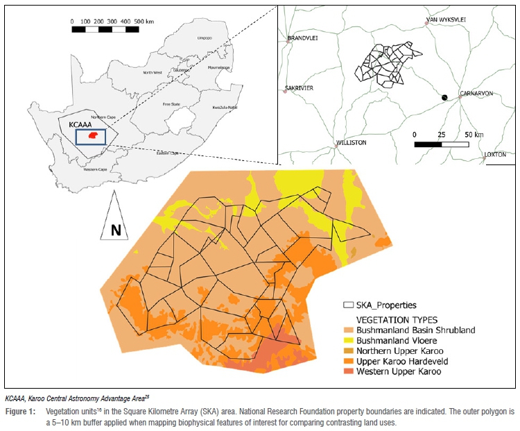
In South Africa, the core section of the SKA telescope is being developed in the Upper Karoo and Bushmanland region of the Northern Cape north of the Carnarvon Research Station between the villages of Brandvlei, Williston, Van Wyksvlei and Carnarvon and within the Nama-Karoo Biome (Figure 1). In planning to develop an environmental observation research platform, SAEON collated relevant information on the area in a comprehensive environmental baseline report21, summarised in this section.
Climate
Most precipitation falls as rain, while hail, fog and snow are rarely recorded. Mean annual precipitation throughout the study area is less than 200 mm and increases with altitude from about 150 mm on the plains (960 m.a.s.l.) to 200 mm in the uplands (1100-1300 m.a.s.l.). Inter-annual variability in precipitation is high (CV = 44-60%). Above-average precipitation occurred during the mid-1970s, and short intermittent droughts occurred from 1934 to 1995. Currently, the area is experiencing a lengthy drought.32 Rainfall cycles are apparent in the record at a period of 40-60 years33 and for shorter periods32.
Mean monthly temperature minima of 15 °C and maxima of 35 °C occur between December and February (summer) and minima of 5 °C and maxima of 20 °C between June and August (winter); however, extremes of 41 °C and -11 °C have been recorded in summer and winter, respectively. Mean humidity is below 50% for most of the year with a nadir in winter. Wind run peaks in the summer from November to February.34 Potential monthly evaporation is, on average, 16-fold of monthly precipitation; the summer rate is 7-fold the winter rate. Evaporation from an A-Pan at Brandvlei has a mean of 5.5 mm/day (range 1-14 mm) and 165 mm/ month with a mean annual evaporation (2002-2018) of 1992±82 mm.
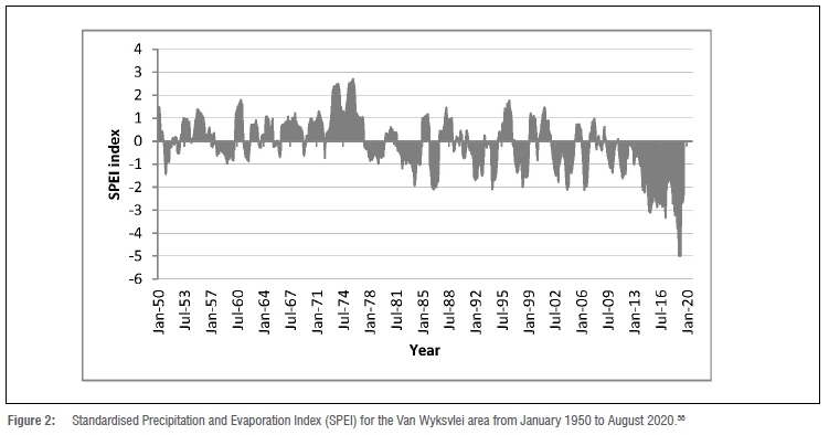
Standardised Precipitation Evapotranspiration Index (SPEI) uses both precipitation and evapotranspiration to quantify drought.28,35 The SPEI graph of the SKA area from January 1950 to August 2020 (Figure 2) shows the 12-month running mean compiled from SPEI-base data for 30.25°S, 21.75°E.36 Drought indices below -2 signify severe drought. For the SKA area at the start of 2020, the index declined to -5, which is considered exceptionally extreme. Starting in 2014 and continuing until the end of the data set in August 2020, this drought is the longest and most intense recorded during the 70-year period of this record. Furthermore, a clear directional shift in SPEI is evident (Figure 2).
Topography, geology and soils
Dolerite and Ecca shale flat-topped mesas are scattered across the plains. Ephemeral pans or 'vloere' occur in depressions in the lowest parts of the landscape. Soils of the elevated areas are skeletal, deeper alluvial soils occur on the plains and depressions, and colluvial deposits are present on the foot slopes. The area between the hills is covered with pebbly alluvium and sand and underlain by thinly layered shale of the Tierberg Formation shales.37 The unconsolidated sand, silt and clay sediments are generally less than 2 m deep.37 Calcrete is widespread in the landscape and occasionally quaternary, reddish aeolian sand can be found.37
Hydrology
Hydrological features include an extensive network of ephemeral rivers, wetland depressions and overland drainage lines. Depressional wetlands occasionally hold shallow water over a large area after inundation. However, such events are rare, and most remain desiccated for many years or decades.21,38 The surface flow of Karoo ephemeral rivers depends on groundwater discharge following precipitation at higher elevations, although there are few perennial springs and seeps.39 The connection between the groundwater and surface water components remains poorly understood. The water table is generally shallow (12±5 m), and water quality is generally poor.21
Evidence for climate change
Temperatures have risen throughout South Africa, with increases in warm extremes and decreases in cold spells being more substantial in the western regions.26 In the SKA area, Van Wyksvlei (1939-2009) showed trends towards warmer extremes. The percentage of days per year when the maximum temperature exceeded the 90th percentile of the 1971-2000 base period increased at 2.26% per decade in the Northern Cape.26 Van Wyksvlei and three other stations in the western central part of the country were the only stations for which data indicated a significant increase in the absolute annual maximum. Mean and maximum daily temperatures increased in the Northern Cape between 1960 and 2010, mostly after 2000.27 There were no trends in annual or seasonal rainfall over this period, such that, even without a decline in rainfall, increased evapotranspiration resulting from higher temperatures was likely to have increased the frequency and severity of drought episodes, perhaps already evident in the region (Figure 2).28
Biotic components
The SKA falls within the Nama-Karoo Biome.16 Four Nama-Karoo vegetation units are represented, namely Western Upper Karoo, Upper Karoo Hardeveld and Northern Upper Karoo on the mountains and ridges, and Bushmanland Basin Shrubland on the lower altitude plains (Figure 1). Inland Azonal vegetation, comprising dry river beds and depressional wetlands collectively termed Bushmanland Vloere, intersperses and dissects these vegetation types.
The Milton et al.21 baseline study reviewed the formal and grey literature, and database entries on the fauna and flora recorded from Quarter Degree Square 3021, and, to a lesser extent, its adjacent areas (Supplementary tables 1 and 2). The number of species recorded included 78 mammal, 142 bird, 56 reptile and 9 amphibian species. The avifauna, reptiles, amphibians and a few invertebrate groups such as darkling and dung beetles, and aquatic invertebrates are relatively well documented. The distributions of small mammals and bats require further investigation. Most invertebrate groups are poorly collected, and no records were found for some (e.g. molluscs, millipedes). The 10 most speciose floral families are Aizoaceae, Amaranthaceae, Apocynaceae, Asteraceae, Fabaceae, Hyacinthaceae, Iridaceae, Malvaceae, Poaceae, and Scrophulariaceae. However, ephemeral components such as fungi, geophytes and short-lived herbs are incompletely documented.
Conditions for conducting environmental research at SKA
Apart from two recently published vegetation studies on the SKA property22,40, the only other published ecological research from the vicinity are studies of vegetation from Carnarvon Research Station7,8 and of invertebrates in nearby Bushmanland wetlands38,41,42. Most of the documentation of environmental conditions has been in government reports (e.g. Du Toit et al.33), or historical accounts by early travellers (e.g. Burchell43; Kirby44), or information extracted from early accounts (e.g. Skead et al.45; Boshoff et al.46).
The SKA offers an unprecedented opportunity to study ecosystem re-organisation across a landscape following cessation of sustained livestock grazing. Vegetation management treatments such as disturbance, restoration (natural and assisted), and alien vegetation removal are present in the same landscape. The potential value of this effort is enhanced because the SKA area is representative of a large part of the arid western interior of South Africa - an area experiencing increasing temperature and water stresses (Figure 2).26 Findings can also help us understand natural drivers of change and how these impact social and economic elements in the region. State ownership of a large part of the study area should ensure uninterrupted long-term study and observation into the future that would contribute to the implementation of the Integrated Environmental Management Plan by the SARAO and the management of the Meerkat National Park by SANParks.29
Conceptual model of the possible impacts of land-use change in the SKA region
Future land-use scenarios
The juxtaposition of the extensive livestock-free core area of the SKA with surrounding land still actively farmed with livestock allows testing of land-use scenarios at both small and large scales (Figure 3). Additionally, historical and recent disturbances have scarred the landscape, and the timespan or trajectory for recovery with or without intervention is unknown. Land degradation includes bush thickening by indigenous non-forage shrubs (e.g. Rhigozum trichotomum) and invasion by alien trees (Prosopis spp.)21,22, which influence the landscape's biotic and abiotic components. Investigating recovery processes under optimal conditions in terms of stocking rate would facilitate ecological restoration at SKA that can inform Environmental Impact Assessments elsewhere and environmental management regulations in general.
Future land-use scenarios for the SKA and adjacent area may include: (Figure 3, scenario A) exclusion of livestock grazing with the low numbers of wildlife remaining on the SKA and slowly increasing through natural processes, (B) re-introduction of wildlife onto the property thereby increasing wildlife numbers and diversity more rapidly than would have occurred naturally, (C) adjacent rangeland with livestock, i.e. the status quo for most of the Nama-Karoo region, (D) some areas subjected to overgrazing by livestock and/or wildlife, (E) historically disturbed areas resulting from ploughing, cropping or other agricultural practices which fail to recover without active intervention, (F) the condition of past disturbed areas improving with active intervention, (G) recently disturbed areas remaining in a poor state or retrogressing without active intervention, or (H) recently disturbed areas stabilising or improving after active intervention.
Predicted trajectories of change
We predict that the scenarios mentioned above will affect private land and/or the SKA property as follows. Firstly, within constraints of low rainfall, the removal of livestock allows for a slow (>20 to 40 years) increase in vegetation cover and decrease in bare soils, accompanied by gradual changes in biotic community composition (e.g. Milton and Hoffman47; Van Rooyen et al.48). Secondly, re-introducing wildlife after removing livestock will follow the first trajectory unless wildlife numbers escalate (e.g. Van Rooyen et al.48,49). The third possible trajectory results from continued livestock grazing under sustainable stocking rates, driven by natural environmental fluctuations, as for the recent past. The fourth pathway is associated with overgrazing by livestock and/or wildlife causing decreasing vegetation cover, increasing soil exposure, and changing vegetation structure and species composition (e.g. Milton50; Milton and Hoffman47; Van Rooyen et al.48,49). Historically disturbed areas without intervention would follow a fifth pathway in which there is a slow increase in vegetation cover, decreasing exposed soils, and slow floral and faunal enrichment. A sixth trajectory accelerates and enhances the fifth with ecological restoration (e.g. Milton and Hoffman47). The seventh, with no active intervention at newly disturbed sites, leaves the area mostly bare, with low vegetation cover, depleted flora and fauna, and a state of degradation from which recovery is slow (e.g. Milton and Hoffman47). Recovery of vegetation cover and community composition at such sites would be quicker with active intervention, giving a final pathway.
Factors influencing trajectories of change
The land-use scenarios and the predicted trajectories of change are affected by numerous internal and external factors. These include the (1) historical, current and changing land use, (2) episodic events, (3) vegetation fluctuations, (4) faunal variations, (5) social influences, and (6) global change.
Historical disturbances (Figure 3, driver 1), especially overgrazing, ploughing, cropping and damming of rivers, remain visible in the Karoo vegetation for centuries (e.g. Milton50; Milton and Hoffman47; Milton et al.21). The combination of past and current land uses affects ecosystem changes (e.g. Milton50; Van der Merwe et al.8). Episodic events alter the physical landscape (Figure 3, driver 2). Exceptional wet periods drive vegetation flushes16,51,52 and associated irruptions of animal populations and subsequent mass movements of birds53, springbok54, hyrax55, locusts56 and rapidly increase the abundance of branchiopods in pans38. Flash floods also cause degradation through erosion and affect geohydrology.57 Droughts and erosive dust storms can result in massive dieback of vegetation and animal populations.56,58
Exceptionally wet periods promote large-scale recruitment of some plant species, with the seed bank and land management determining the resulting vegetation.58,59 Similarly, reduced stocking rates allow plant species to grow, set seed and germinate, with recruits replacing palatable and unpalatable species at different frequencies50,58,59 (Figure 3, driver 3).
In the Karoo, some faunal species are known for their population irruptions and crashes that follow bursts of primary productivity after rainfall, a pattern that is characteristic of usually dry areas.16,52 Populations of hyrax, springbok, rodents and locusts, for example, irrupt during favourable conditions and then crash or move as food sources become scarce.54-56 These population irruptions and crashes can have knock-on effects on predators, such as jackal (Canis mesomelas), caracal (Caracal caracal) and Verreaux's eagles (Aquila verreauxii) (Figure 3, driver 4). The amplitude of such population cycles could change following the absence of livestock and closure of artificial water points.
Social and economic pressures brought about by local, national and global factors affect employment and educational opportunities, state of health and well-being.20 Additional to these influences, climatic events such as long periods of drought may decrease rangeland condition, thereby compromising farming activities. This may lead to large-scale unemployment, with people moving to the surrounding villages, thereby placing additional pressure on natural resources such as fuelwood, wildlife and medicinal plants (Figure 3, driver 5). At a higher level, global change due to increasing CO2 levels, temperatures, frequency and intensity of droughts or cold spells, and shifting seasons also has local effects (Figure 3, driver 6). These changes are not controlled at a local or national level, but knowledge of responses at these levels is necessary to inform adaptions and mitigation measures to continue working and living in the region.
Development of an environmental research platform at the SKA
For long-term observation to contribute to improved understanding, surveillance of relevant drivers and appropriate response variables is essential. Future potential change is also more confidently addressed when there is a clearer understanding of historical change. To attain this aim, SAEON will monitor climate at a series of distributed sites at SKA using weather stations and other instrumentation, deployed according to regulations concerning radio frequency interference. A primary use of the weather data will be an effort to distinguish natural climatic variability from global increases. Climate monitoring is fundamental to interpret data of the abiotic and biotic environment at SKA and the adjacent farmland.
Vegetation can be monitored by establishing and surveying permanent plots at SKA and on adjacent farmland at different scales across vegetation units, land types and landforms60, and ensuring data collection methods are constant through time61. This design will contribute to a landscape-scale (sensu Sparrow et al.60) network of study plots across different climatic zones in South Africa and enhance continental and global comparisons62. Similar methodology was developed for surveillance of Australian rangelands as part of the Australian Terrestrial Ecosystem Research Network.62
Responses to land use and the change in land use will be investigated by monitoring the impact of grazers (livestock and wildlife) on vegetation change, enhanced by studying the effect of variable stocking rates on animal types and distributions of individual animals. Biodiversity will be monitored in detail at a range of intensively studied sites and at less-intensely studied sites by monitoring plant and animal populations, community composition and population dynamics over time and across environmental gradients within the SKA and on adjacent farmland. In addition, ongoing surveillance during regular site visits to conduct monitoring is possibly the only means whereby infrequent events and their effects on the environment can become better understood.
Hydrological functioning will be investigated in order to better understand the hydrology of the Karoo and specifically its functioning in dryland pan systems. Prolonged and extreme drought and heat can elevate the significance of moisture availability in cooler months, driving fundamental changes in plant composition63, for example, counterintuitively favouring C3 plants64. This emphasises the need to monitor seasonal shifts in rainfall and its effects. Historical shifts in plant community composition associated with past droughts could perhaps be detected by analysing plant remains in dung. The numerous hyrax middens at SKA represent a palaeoenvironmental archive65, which can be actively calibrated with current measures of changes in plant community composition driven by climate change, drought, and land-use changes.
Global climate change and its influence on ecosystem structure, functioning and processes will impact not only the Meerkat National Park but also the surrounding sparsely populated agricultural land and the economy of the local villages that are vulnerable to environmental extremes.66 The environmental dynamics of the area should be studied by integrating traditional disciplinary sciences in a transdisciplinary, holistic long-term socio-ecological research67 approach.
Desired outcomes of the environmental research platform at SKA
Land use and the resulting land-cover changes at SKA present unprecedented opportunities for arid lands research. The abrupt removal of livestock from a large area of rangeland and gradual system reorganisation under various land uses and stocking rates allow for the investigation of multiple treatments and trajectories of change in biotic and abiotic components. The changes can be compared to changes on adjacent rangelands still grazed by livestock. Long-term monitoring of changes in various components of the most arid ecosystem compared with less arid systems should provide insights and understanding of the contributions of global climate change superimposed on land-use change.
Acknowledgements
The National Research Foundation (South Africa) provided some financial assistance, but the paper's content is solely the authors' responsibility. We thank Tracy Cheetham, Alice Pienaar-Marais, Dawie Fourie, Nomcebo Buthelezi and Gabriela Duncan of the South African Radio Astronomy Observatory (SARAO) for discussions and information concerning the SKA. South African National Parks (SANParks) is acknowledged for permission to work in Meerkat National Park and for discussions with Hugo Bezuidenhout, Hendrik Malgas, Nkabeng Maruping-Mzileni, Ernest Daemane and Abel Matsapula. Both SARAO and SANParks are thanked for their input into this manuscript.
Competing interests
We have no competing interests to declare.
Authors' contributions
All authors contributed to the conceptualisation of the article; S.J.M. and W.R.J.D. collated the baseline data; H.v.d.M. was responsible for writing the article with substantial input from all co-authors.
References
1. Strayer D, Glitzenstein JS, Jones CG, Kolasa J, Likens GE, McDonnell MJ, et al. Long-term ecological studies: An illustrated account of their design, operation, and importance to ecology. Occasional Publication of the Institute of Ecosystem Studies. 1986;2. [ Links ]
2. Likens GE. Long-term studies in ecology. Approaches and alternatives. Berlin: Springer Verlag; 1989. https://doi.org/10.1007/978-1-4615-7358-6 [ Links ]
3. Whitford WG. Jornada Validation Site Report. U.S. International Biological Program, Desert Biome. Final progress reports: Validation studies RM 77-4. Logan, UT: Utah State University;1979. p. 93-102. [cited 2021 Oct 14]. Available from: https://digitalcommons.usu.edu/cgi/viewcontent.cgi?article=1280&context=dbiome_memo [ Links ]
4. Hughes BB, Beas-Luna R, Barner AK, Brewitt K, Brumbaugh DR, Cerny-Chipman EB, et al. Long-term studies contribute disproportionately to ecology and policy. BioScience. 2017;67:271-281. https://doi.org/10.1093/biosci/biw185 [ Links ]
5. Arena G, Van der Merwe H, Todd SW, Pauw MJ, Milton SJ, Dean WRJ, et al. Reflections, applications and future directions of long-term ecological research at Tierberg. Afr J Range Forage Sci. 2018;35(3-4):257-265. https://doi.org/10.2989/10220119.2018.1513072 [ Links ]
6. Grootfontein Agricultural Development Institute [homepage on the Internet]. Available from: http://gadi.agric.za/ [ Links ]
7. Harmse CJ, Gerber HJ. Effect of stocking density on vegetation and animal performance within the semi-arid shrublands of the Karoo, South Africa. Afr J Range Forage Sci. 2018;35:13-22. https://doi.org/10.2989/10220119.2018.1440629 [ Links ]
8. Van der Merwe H, Du Toit JCO, Van den Berg L, O'Connor TG. Impact of sheep grazing intensity on vegetation at the Arid Karoo: Stocking Rate Trial after 27 years, Carnarvon, South Africa. J Arid Environ. 2018;155:36-45. https://doi.org/10.1016/j.jaridenv.2018.02.005 [ Links ]
9. Clutton-Brock T, Sheldon BC. Individuals and populations: The role of long-term, individual-based studies of animals in ecology and evolutionary biology. Trends Ecol Evol. 2010;25:562-573. https://doi.org/10.1016/j.tree.2010.08.002 [ Links ]
10. Buffington LC, Herbel CH. Vegetational changes on a semidesert grassland range from 1858 to 1963. Ecol Monogr. 1965;35:139-164. https://doi.org/10.2307/1948415 [ Links ]
11. Hennessy JT, Gibbens RP Tromble JM, Cardenas M. Vegetation changes from 1935 to 1980 in mesquite dunelands and former grasslands of southern New Mexico. J Range Manag. 1983;36:370-374. https://doi.org/10.2307/3898490 [ Links ]
12. Schlesinger WH, Reynolds JF, Cunningham GL, Huenneke LF, Jarrell WM, Virginia RA, et al. Biological feedbacks in global desertification. Science. 1990;247:1043-1048. https://doi.org/10.1126/science.247.4946.1043 [ Links ]
13. Reynolds JF, Grainger A, Stafford Smith DM, Bastina G, Garcia Barros L, Fernández RJ, et al. Scientific concepts for an integrated analysis of desertification. Land Degrad Dev. 2011;22:166-183. https://doi.org/10.1002/ldr.1104 [ Links ]
14. Wild S. Searching African skies: The Square Kilometre Array and South Africa's quest to hear the songs of the stars. Johannesburg: Jacana Media; 2013. [ Links ]
15. Camilo F, Scholz P Serylak M, Buchner S, Merryfield M, Kaspi VM, et al. Revival of the Magnetar PSR J1622-4950: Observations with MeerKAT, Parkes, XMM-Newton, Swift, Chandra, and NuSTAR. ApJ. 2018;856:180-191. https://doi.org/10.3847/1538-4357/aab35a [ Links ]
16. Mucina L, Rutherford MC, editors. The vegetation of South Africa, Lesotho and Swaziland. Pretoria: South African National Biodiversity Institute; 2006. [ Links ]
17. Zietsman L, editor. Observations on environmental change in South Africa. Stellenbosch: African SUN MeDIA; 2011. [ Links ]
18. Council for Scientific and Industrial Research (CSIR). Strategic environmental assessment for the South African mid-frequency array of SKA Phase 1. CSIR report CSIR/02100/EMS/ER/2016/15240/B. Pretoria: CSIR; 2016. [ Links ]
19. Gastrow M, Oppelt T. The Square Kilometre Array and local development mandates in the Karoo. J South Afr. 2019;45:711-728. https://doi.org/10.1080/03057070.2019.1642679 [ Links ]
20. Walker C. Cosmopolitan Karoo: Land, space and place in the shadow of the Square Kilometre Array. J South Afr. 2019;45:641-662. https://doi.org/10.1080/03057070.2019.1645493 [ Links ]
21. Milton SJ, Henschel JR, Van der Merwe H, Dean WRJ, Meyer-Milne E, Gerber H. Environmental baseline review of the core area and surrounds of the Square Kilometre Array (SKA). SAEON report and appendices. Pretoria: South African Environmental Observation Network (SAEON); 2021. https://doi.org/10.15493/saeon.arid.10000001 [ Links ]
22. Van der Merwe H. Vegetation of the Square Kilometre Array (SKA), South Africa: A baseline to measure local and global change. S Afr J Bot. 2020;132:22-29. https://doi.org/10.1016/j.sajb.2020.03.025 [ Links ]
23. Milton SJ, Dean WRJ, O'Connor TG, Mills AJ. Scaling up from site-based research to a national research and monitoring network: Lessons from Tierberg Karoo Research Centre and other design considerations. S Afr J Sci. 2007;103:311-317. [ Links ]
24. O'Connor TG. Understanding environmental change in complex systems: SAEON core science framework. Pretoria: South African Environmental Observation Network (SAEON); 2010. [ Links ]
25. Astronomy Geographic Advantage Act 21 of 2007, Republic of South Africa. South African Government Gazette. 2008;31157:1-56. https://www.gov.za/sites/default/files/gcis_document/201409/gg31157nn666apg1-30.pdf [ Links ]
26. Kruger AC, Sekele SS. Trends in extreme temperature indices in South Africa: 1962-2009. Int J Climatol. 2013;33:661-676. https://doi.org/10.1002/joc.3455 [ Links ]
27. MacKellar N, New M, Jack C. Observed and modelled trends in rainfall and temperature for South Africa: 1960-2010. S Afr J Sci. 2014;110(7/8), Art. #2013-0353, 13 pages. https://doi.org/10.1590/sajs.2014/20130353 [ Links ]
28. Vicente-Serrano SM, Beguerias S, Lopez-Moreno JI. A multiscalar drought index sensitive to global warming: The Standardised Precipitation Evapotranspiration Index. J Clim. 2010;23:1696-1718. https://doi.org/10.1175/2009JCLI2909.1 [ Links ]
29. South African Radio Astronomy Observatory, National Research Foundation. Integrated Environmental Management Plan (IEMP) for SKA Phase 1 mid-frequency array (SKA1_MID) in South Africa [document on the Internet]. No date [cited 2021 Jun 21]. Available from: https://www.sarao.ac.za/about/strategic-environmental-assessment/ [ Links ]
30. Aronson J, Milton SJ, Blignaut JN. Restoring natural capital: Science, business, and practice. Washington / London: Island Press / Covelo; 2007. [ Links ]
31. Shriver RK, Andrews CM, Pilliod DS, Arkle RS, Welty JL, Germino MJ, et al. Adapting management to a changing world: Warm temperatures, dry soil, and interannual variability limit restoration success of a dominant woody shrub in temperate drylands. Glob Chang Biol. 2018:1-11. https://doi.org/10.1111/gcb.14374 [ Links ]
32. Harmse CJ, Du Toit JCO, Swanepoel A, Gerber HJ. Trend analysis of long-term rainfall data in the Upper Karoo of South Africa. Trans R Soc S Afr. 2021;76(1):1-12. https://doi.org/10.1080/0035919X.2020.1834467 [ Links ]
33. Du Toit JCO, Van den Berg L, O'Connor TG. A summary of rainfall at the Carnarvon Experiment Station, 1931-2013. Grootfontein Agric. 2015;15:27-35. [ Links ]
34. Meyer TC. Weidingskapsiteitstudies op veld in die dorre Karoo [Grazing capacity studies on veld in the arid Karoo] [thesis]. Bloemfontein: University of the Free State; 1992. Afrikaans. [ Links ]
35. Beguería S, Vicente-Serrano SM, Angulo MA. Multiscalar global drought dataset: The SPEIbase: A new gridded product for the analysis of drought variability and impacts. Bull Am Meteorol Soc. 2010;91:1351-1356. https://doi.org/10.1175/2010bams2988.1 [ Links ]
36. Global SPEI database [webpage on the Internet]. No date [cited 2020 Oct 12]. Available from: http://spei.csic.es/database.html [ Links ]
37. Cronwright MS, Bosch PJA, Forbes C, Cole J. Assessment of the geological and geotechnical constraints and mitigation measures which may be required for the location of the Square Kilometre Array core site and the Karoo array telescope on the Karoo and Namaqualand sites. Internal report No.: 20050121. Pretoria: Council for Geosciences; 2005. [ Links ]
38. Meyer-Milne E, Mlambo MC, Rogers DC. Distribution of clam shrimps (Crustacea: Laevicaudata and Spinicaudata) in South Africa, with new records from the Northern Cape Province. Zool Stud. 2020;59:39. https://doi.org/10.6620/ZS.2020.59-39 [ Links ]
39. Snaddon K, Ollis D, Ngobela T, Kirkwood D. Aquatic ecosystems assessment of the SKA Phase 1 in South Africa. Pretoria: CSIR; 2017. Available from: http://www.skaphase1.csir.co.za/wp-content/uploads/2017/01/Aquatic-Assessment.pdf [ Links ]
40. Van der Merwe H, Geldenhuys C. Proposed long-term monitoring protocol and applications for Aloidendron dichotomum populations. S Afr J Bot. 2017;109:253-262. https://doi.org/10.1016/j.sajb.2017.01.008 [ Links ]
41. Hamer M, Rayner NA. A note on the unusual Crustacean community of a temporary pool in the Northern Cape. S Afr J Aquatic Sci. 1996;22(1/2):100-104. https://doi.org/10.1080/10183469.1996.9631376 [ Links ]
42. Anderson MD. The status of flamingos in the Northern Cape Province, South Africa. Ostrich. 2000;71:425-437. https://doi.org/10.1080/00306525.2000.9639859 [ Links ]
43. Burchell WJ. Travels in the interior of southern Africa, Vol. 1. London: The Batchworth Press; 1822. Reprinted 1953. https://doi.org/10.5962/bhl.title.100911 [ Links ]
44. Kirby PR, editor. The diary of Dr Andrew Smith, Director of the 'Expedition for Exploring Central Africa', 1834-1836. Publications No. 20 & 21, 1939-1940. Cape Town: Van Riebeeck Society; 1940. [ Links ]
45. Skead CJ, Boshoff A, Kerley G, Lloyd P. Historical incidence of the larger land mammals in the broader western and northern Cape. 2nd ed. Port Elizabeth: Centre for African Conservation Ecology, Nelson Mandela University; 2011. [ Links ]
46. Boshoff A, Landman M, Kerley G. Filling the gaps on the maps: Historical distribution patterns of some larger mammals in part of southern Africa. Trans Roy Soc S Afr. 2016;71:23-87. https://doi.org/10.1080/0035919x.2015.1084066 [ Links ]
47. Milton SJ, Hoffman M.T. The application of state-and-transition models to rangeland research and management in arid succulent and semi-arid grassy Karoo, South Africa. Afr J Range Forage Sci. 1994;11:18-26. https://doi.org/10.1080/10220119.1994.9638349 [ Links ]
48. Van Rooyen MW, Le Roux A, Geldenhuys C, Van Rooyen N, Broodryk NL, Van der Merwe, H. Long-term vegetation dynamics (40 yr) in the Succulent Karoo, South Africa: Effects of rainfall and grazing. Appl Veg Sci. 2015;18:311-322. https://doi.org/10.1111/avsc.12150 [ Links ]
49. Van Rooyen MW, Le Roux A, Van der Merwe H, Van Rooyen N, Geldenhuys C. Long-term vegetation change (>20 years) in the plains habitat on the Goegap Nature Reserve, Succulent Karoo, South Africa. Afr J Range Forage Sci. 2018;35(3-4):289-302. https://doi.org/10.2989/10220119.2018.1498802 [ Links ]
50. Milton SJ. Growth, flowering and recruitment of shrubs in grazed and in protected rangeland in the arid Karoo, South Africa. Vegetatio. 1994;111:17-27. [ Links ]
51. Lloyd JW. Phytosociology of the Vaalputs radioactive waste disposal site, Bushmanland, South Africa. S Afr J Sci. 1989;55:372-382. https://doi.org/10.1016/s0254-6299(16)31191-7 [ Links ]
52. Milton SJ, Dean WRJ. Disturbance, drought and dynamics of desert dune grassland, South Africa. Plant Ecol. 2000;150:37-51. https://doi.org/10.1023/A:1026585211708 [ Links ]
53. Dean WRJ. Nomadic desert birds. Berlin: Springer; 2004. https://doi.org/10.1007/978-3-662-08984-2 [ Links ]
54. Roche CJ. Ornaments of the desert - Springbok treks in the Cape Colony, 1774-1908 [thesis]. Cape Town: University of Cape Town; 2004. [ Links ]
55. Davies RAG. Black eagle Aquila verreauxii predation on rock hyrax in the Karoo [PhD thesis]. Pretoria: University of Pretoria; 2000. [ Links ]
56. Henschel JR. Locust times - monitoring populations and outbreak controls in relation to Karoo natural capital. Trans R Soc S Afr. 2015;70:135-143. https://doi.org/10.1080/0035919X.2015.1046974 [ Links ]
57. Vickery KJ, Eckardt FD, Bryant RG. A sub-basin scale dust plume source frequency inventory for southern Africa, 2005-2008. Geophys Res Lett. 2013;40:5274-5279. https://doi.org/10.1002/grl.50968 [ Links ]
58. Van der Merwe H, Milton SJ. Testing the Wiegand-Milton model: A long-term experiment to understand mechanisms driving vegetation dynamics in arid shrublands. Austral Ecol. 2019;44:49-59. https://doi.org/10.1111/aec.12651 [ Links ]
59. Milton SJ, Wiegand T. How grazing turns rare seedling recruitment events to non-events in arid environments. In: Breckle S-W., Veste M, Wucherer W, editors. Sustainable land-use in deserts. Heidelberg: Springer; 2001. https://doi.org/10.1007/978-3-642-59560-8_20 [ Links ]
60. Sparrow BD, Edwards W, Munroe SEM, Wardle GM, Guerin GR, Bastin JF, et al. Effective ecosystem monitoring requires a multi-scaled approach. Biol Rev. 2020;95(6):1706-1719. https://doi.org/10.1111/brv.12636 [ Links ]
61. Lindenmayer DB, Burns EL, Tennant P, Dickman CR, Green PT, Keith DA, et al. Contemplating the future: acting now on long-term monitoring to answer 2050's questions. Austral Ecol. 2015;40(3):213-224. https://doi.org/10.1111/aec.12207 [ Links ]
62. Sparrow BD, Foulkes JN, Wardle GM, Leitch EJ, Caddy-Retalic S, Van Leeuwen SJ, et al. A vegetation and soil survey method for surveillance monitoring of rangeland environments. Front Ecol Evol. 2020;8:15-17. https://doi.org/10.20944/preprints201911.0178.v1 [ Links ]
63. Duniway MC, Petrie MD, Peters DPC, Anderson JP, Crossland K, Herrick JE. Soil water dynamics at 15 locations distributed across a desert landscape: insights from a 27-yr dataset. Ecosphere. 2020;9(7):1-36. https://doi.org/10.1002/ecs2.2335 [ Links ]
64. Knapp AK, Chen A, Griffin-Nolan RJ, Baur LE, Carroll CJW, Gray JE, et al. Resolving the Dust Bowl paradox of grassland responses to extreme drought. Proc Natl Acad Sci USA. 2020;117:22249-22255. https://doi.org/10.1073/pnas.1922030117 [ Links ]
65. Chase BM, Scott L, Meadows ME, Gil-Romera G, Boom A, Carr AS, et al. Rock hyrax middens: A palaeoenvironmental archive for southern African drylands. Quat Sci Rev. 2012;56:107-125. https://doi.org/10.1016/j.quascirev.2012.08.018 [ Links ]
66. Toerien D. Productive knowledge, poverty and the entrepreneurial challenges of South African towns. S Afr J Sci. 2018;114(11/12), Art. #4765, 8 pages. https://doi.org/10.17159/sajs.2018/4765 [ Links ]
67. Dirnböck T, Haase P Mirtl M, Pauw J, Templer PH. Contemporary International Long-Term Ecological Research (ILTER) - from biogeosciences to socioecology and biodiversity research. Reg Environ Change. 2019;19:309-311. https://doi.org/10.1007/s10113-018-1445-0 [ Links ]
 Correspondence:
Helga van der Merwe
Email: h.vandermerwe@saeon.nrf.ac.za
Received: 26 Mar. 2021
Revised: 21 June 2021
Accepted: 21 June 2021
Published: 29 Nov. 2021
Editors: Teresa Coutinho, Salmina Mokgehle
Funding: National Research Foundation (South Africa)
Supplementary Data
The supplementary data is available in pdf: [Supplementary data]

