


Servicios Personalizados
Articulo
 Inglés (pdf)
 Articulo en XML
 Referencias del artículo
Indicadores

Links relacionados
-
 Citado por Google
 -
 Similares en Google
Compartir

 Permalink
South African Journal of Science
versión On-line ISSN 1996-7489
versión impresa ISSN 0038-2353
S. Afr. j. sci. vol.117 no.7-8 Pretoria jul./ago. 2021
http://dx.doi.org/10.17159/sajs.2021/8668
RESEARCH ARTICLE
Gold mining's toxic legacy: Pollutant transport and accumulation in the Klip River catchment, Johannesburg
Shaeen ChettyI; Letitia PillayII; Marc S. HumphriesI
ISchool of Chemistry, University of the Witwatersrand, Johannesburg, South Africa
IIMolecular Sciences Institute, School of Chemistry, University of the Witwatersrand, Johannesburg, South Africa
ABSTRACT
Waste from gold mines is considered to constitute the largest single source of waste pollution in South Africa and contributes significantly to acid mine drainage, which remains one of the country's most serious environmental and socio-economic issues. Run-off from the Central Rand Goldfield discharges into wetlands along the Klip River, which are known to be important sinks for toxic pollutants. The aim of this study was to examine the transport, migration and sequestration of metal pollutants in the upper Klip River catchment in further detail. Analyses reveal that the majority of pollutants are associated with contaminant plumes that emanate from mine dumps and enter the wetland via groundwater recharge. This water carries highly elevated concentrations of Co, Ni, Zn, U and rare earth elements, which are naturally sequestered within the wetland, largely through precipitation and adsorption. While surface runoff from mine dumps severely contaminates watercourses within the upper catchment, surface inputs are considered relatively minor contributors to the overall pollutant load entering the Klip River wetland, although aerosol fallout is an important source of Pb. The extensive accumulation of metals within the Klip River wetland reflects the contaminant legacy associated with gold mining on the Witwatersrand and highlights the vital role this natural system has played in trapping vast quantities of toxic pollutants and remediating downstream waters. Contaminant plumes associated with mine dumps will likely persist for decades; preventing further deterioration of the Klip River wetlands is thus critical for safeguarding water sources in the region.
SIGNIFICANCE:
• Run-off and groundwater emanating from the Central Witwatersrand Basin is highly contaminated with toxic metals.
• The seepage of acidic water from mine waste dumps is considered the primary source of contamination.
• Significant quantities of pollutants are trapped naturally within the Klip River wetland.
• Preventing further deterioration of the Klip River wetlands is critical for the protection of freshwater resources in the region.
Keywords: acid mine drainage, Witwatersrand, gold mining, metal enrichment, wetland
Introduction
The Witwatersrand Basin is the world's largest gold resource; it has yielded more than one third of all the gold ever produced.1 Although gold mining gave rise to the city of Johannesburg and formed the foundation of the country's economy for over a century, today it presents one of the largest threats to South African water resources and human health.2,3 Gold mining is associated with numerous environmental and health issues, although acid mine drainage (AMD), which emanates both from underground workings and waste disposal sites, is undoubtedly the most serious of these.4
AMD arises from the oxidation of pyrite, ubiquitous in the Witwatersrand gold-bearing conglomerates, to form sulfuric acid. The acid produced mobilises constituents contained in the waste material and underground mine workings, releasing toxic metals such as cobalt, nickel, zinc and uranium. The major source of AMD on the Witwatersrand gold mines is associated with seepage from mine waste dumps, known as tailings storage facilities (TSFs). Waste from gold mines is considered to constitute the largest single source of waste pollution in South Africa.5 There are more than 270 TSFs in the Witwatersrand Basin alone, most of which are unlined and pose serious threats to both groundwater and surface water quality. Although some TSFs have been partially or completely reclaimed, their chemical footprint continues to contaminate groundwater even after the waste material has been removed for reprocessing.6 AMD also arises from the discharge of contaminated water from flooded defunct gold mines and discharge of partially treated water pumped from producing mines has also contributed to the problem in recent years.2,7 Many of the gold mines on the Central and West Rand are situated beneath karst aquifers and must be constantly dewatered to prevent effluent rising to the surface and decanting from flooded mine voids.
The Central Rand, just south of Johannesburg, has been a prolific producer of gold for more than 100 years and is severely affected by the impact of mine tailings. Run-off from the Central Rand Goldfield discharges into wetlands along the Klip River, the principal drainage of the southern portion of Johannesburg. As a result, the Klip River wetland has been accumulating pollution since the founding of Johannesburg and previous studies have highlighted the extensive pollutant load sequestered within the wetland sediments.8,9 While the lower reaches of the wetland are severely degraded, the upper reaches, which receive polluted water from old gold mines, are still reasonably intact and have a beneficial impact on the quality of water entering the Vaal River.10 Given the economic and environmental value of the Klip River wetland, this study was undertaken to examine the transport, migration and sequestration of metal pollutants in the upper Klip River catchment in further detail. Firstly, we assessed the significance of surface run-off and groundwater seepage as potential sources of pollutants by examining metal concentrations in sediment and water samples collected from the upper Klip River catchment. Secondly, we examined the ingress of metal contaminants and variability in their sequestration across the Klip River wetland through the detailed geochemical analysis of a series of sediment cores.
Study area
Regional setting
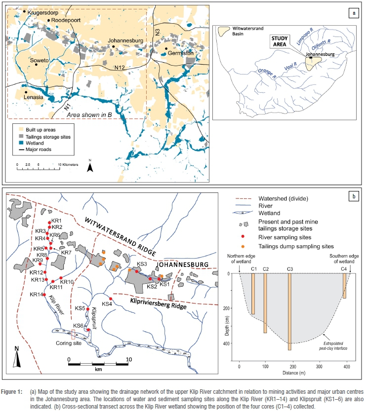
The Klip River basin is a sub-basin of the Vaal-Orange River system and represents the most significant drainage system for the southern Witwatersrand region (Figure 1a).11 The Klip River and Klipspruit are the primary tributaries draining the Witwatersrand mining-industrial complex and discharge into the extensive wetland area further downstream.
Geology and geohydrology
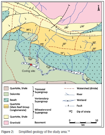
The bedrock geology of the region is summarised in Figure 2. Gold is found in quartz pebble conglomerates, which are hosted in a sequence of siliceous quartzites of the Witwatersrand Supergroup. The Witwatersrand strata are conformably overlain by basaltic volcanic rocks of the Ventersdorp Supergroup, which in turn are overlain by dolomitic rocks of the Transvaal Supergroup. These rocks are karstic and host the Klip River wetlands. The wetlands are sustained predominantly by groundwater recharge from the underlying dolomite. During summer, this discharge is augmented by surface run-off from rainfall, with the Klip River and Klipspruit being the dominant fluvial inputs. The Klip River wetland drains into the Vaal River, which supplies approximately 23% of the South African population with potable drinking water.12 Groundwater from underlying aquifers is also extracted for domestic consumption, and informal settlements use untreated river water for domestic and agricultural purposes.13
Pollutant sources
TSFs represent important sources of pollution within the Witwatersrand Basin and are typically associated with extensive acid plumes that contaminate the local groundwater. The formation of acid plumes is caused by the infiltration of rainfall through the TSFs, resulting in the discharge of contaminated water into nearby streams and rivers.14 The Klip River wetland also receives run-off from several large informal settlements and industrial regions, as well as discharge from three sewerage treatment plants.
Methods
Sampling
Water (n=20) and surface sediment (n=15) samples were collected from the upper Klip River (KR1 - 14) and Klipspruit (kS1 - 6) tributaries during March 2017 (Figure 1). Sampling sites were established based on accessibility and in an attempt to capture downstream variations. The pH and electrical conductivity of samples were measured in field using a portable combination meter (Thermo Scientific Orion Star) calibrated against appropriate standard solutions. Water samples were immediately passed through 0.45-/µm filters, acidified with 1% HNO3 and then refrigerated. Sediment samples were placed in bags and stored at 4 °C. Surface material from several mine TSFs in the upper catchment was also sampled (Figure 1) in order to characterise the chemical composition of gold mine tailings.
A series of four sediment cores (C1-C4) was collected along a 350-m north-south orientated transect established in the upstream, western section of the Klip River wetland (Figure 1). This section of the wetland is characterised by intact reed-covered swamp dominated by Phragmites australis and is considered to have remained relatively undisturbed for the last ~80 years based on examination of historical aerial photography and maps.10 Samples were collected to refusal depth using a Russian peat corer. Sub-samples were taken at 10-cm intervals and sealed in plastic bags for subsequent analysis.
Chemical analysis
Tributary and wetland sediment samples were air-dried, milled and combusted at 500 °C for 4 h to determine loss on ignition. Combusted sample powders (~25 mg) were microwave digested in 9 mL HF:HNO3:HCl (6:3:1) using an Anton Paar Multiwave Go system.16 Solutions were evaporated to dryness following the addition of perchloric acid (0.5 mL), before finally being diluted with 1% HNO3 and spiked with Rh as internal standard. Metal and rare earth element (REE) concentrations were measured against external matrix-matched standards using an Agilent 7800x inductively coupled plasma mass spectrometry (ICP-MS). Procedural blanks were analysed with each digestion batch and used to correct final sample concentrations. Sediment standards PACS-2 and CGL-111 were used to assess the accuracy and reproducibility of the method, with recoveries ranging between 88% and 110% (n=6). Internal precision was typically <3% for all elements. Major elements were analysed by powder X-ray fluorescence using a Bruker Ranger S2, following calibration against a range of local and USGS (US Geological Survey) rock standards.
Metal and REE concentrations in water samples were measured by ICP-MS as reported above. Where possible, porewater was extracted from wetland core samples using direct centrifuge drainage.17 The pH and metal content of porewater samples were determined using the procedures described above.
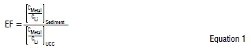
Enrichment factors
To account for variations in sample composition and mineralogy, metal concentrations are expressed as enrichment factors (EF). While the calculation of EF values is subject to several assumptions (see for example Reimann and Caritat18), we apply this normalisation in examining the spatial distribution in metal concentrations within the study area. Enrichment factors were calculated relative to upper continental crust (UCC) values19 using Li as the normalising element (Equation 1). Lithium behaves conservatively in the environment and is not associated with mine waste.
Calculated EF values were assessed and classified into seven categories: (1) <1: no enrichment; (2) 1-3: minor enrichment; (3) 3-5: moderate enrichment; (4) 5-10: moderately severe enrichment; (5) 10-25: severe enrichment; (6) 25-50: very severe enrichment; (7) >50: extremely severe enrichment.20,21 Relationships between metal concentrations were examined using analysis of variance (ANOVA), with significance set at p<0.05.
Results
Surface sediment and water chemistry
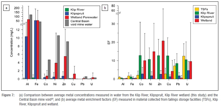
Water samples collected from the upper Klip River catchment and Klipspruit revealed a high degree of chemical variability (Table 1). Highest trace metal concentrations were generally measured in water samples from the Klipspruit, which were typically characterised by high electrical conductivity and elevated levels of Fe and Al. Several other metals were detected in significant concentration in the Klipspruit, notably Co, Ni and Zn. The most contaminated sample was collected in the vicinity of TSFs located in the upper Klipspruit catchment (site KS3) and contained highly elevated concentrations of Fe (330 mg/L), Co (2.1 mg/L), Ni (2.7 mg/L), Zn (2.8 mg/L) and U (0.35 mg/L).
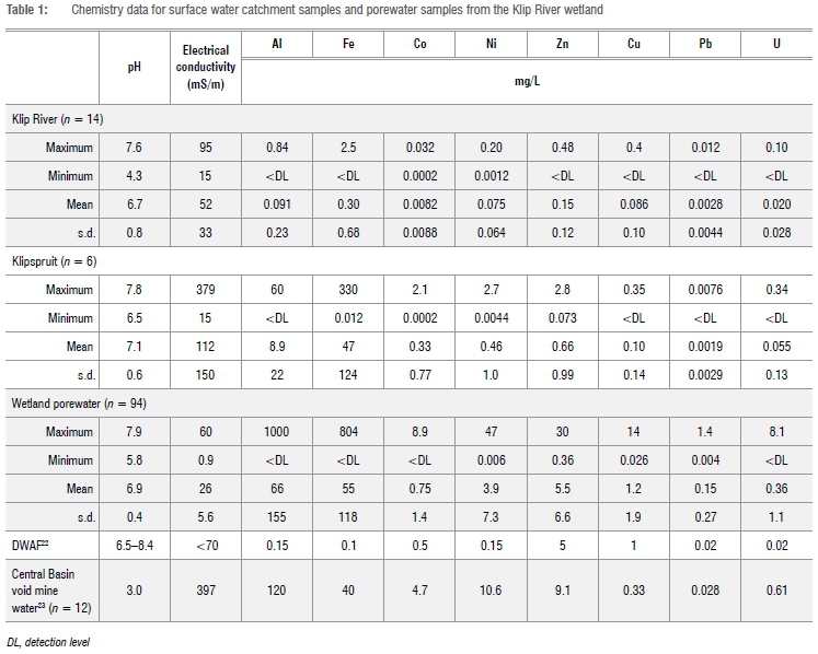
Metal concentrations measured in porewater samples from the Klip River wetland were extremely variable. Average concentrations exceeded those measured in both tributaries, with several porewater samples characterised by exceptionally high levels of Al, Fe, Co, Ni and Zn. Comparatively lower concentrations of Cu, Pb and U were detected. Maximum measured metal porewater concentrations exceeded those typically found in mine void water from the Central Witwatersrand Basin.
Most trace metals were present in highly elevated concentrations in sediments collected from the Klipspruit and upper Klip River catchment (Table 2). Sediments from the Klipspruit were characterised by considerably higher proportions of clay, while those from the Klip River tended to be more organic-rich. Normalised metal concentrations show Klip River sediments to be substantially more enriched than those of the Klipspruit.
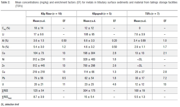
Most metals were present in Klip River sediments at severe enrichment levels, while minor to moderate enrichment characterised sediments from the Klipspruit. Surface material from TSFs comprised predominantly (~95%) SiO2 and Al2O3, but showed enrichment with respect to some trace metals, notably Pb and U. Co and Cu exhibited minor enrichment, while Ni and Zn were not detected in any of the TSF samples analysed.
Core characteristics and major chemical composition
The cores retrieved from the Klip River wetland ranged in length from 140 cm to 440 cm. An underlying clayey sand layer was intercepted at all sites, except site C1, and marked the depth at which point of refusal was reached. The upper sections of all cores were generally composed of organic-rich sediment (peat), with loss on ignition varying between 65% and 85% (Figure 3a). Little variation was observed in pH, both with depth and between individual coring sites.
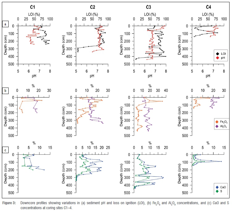
The inorganic fraction of the peat was dominated by fine-grained material composed largely of SiO2 (59±6.9 %) and Al2O3 (16±3.5 %), with cores closer to the edge of the wetland (C1 and C4) characterised by slightly higher SiO2 and Al2O3 contents. Marked variations in Fe2O3 and CaO abundances were observed, both downcore and across the wetland (Figure 3b,c). Fe2O3 was typically enriched in the upper peat layers, with enrichment most prevalent in C2. Peat CaO concentrations ranged between 0.3% and 21%, with cores C2 and C3 characterised by particularly high concentrations. In contrast to Fe2O3, CaO concentrations were typically highest within the middle and lower sections of the peat profiles and were closely matched by variations in total sulfur, which ranged between 0.1% and 11%.
Trace metal profiles
Metal profiles showed substantial downcore variations, although enrichments occurred in different sections of the peat profiles. Co and Ni showed similar downcore trends, with highest enrichment typically found near the base of the peat sequences (Figure 4a,b). Overall, Ni was significantly more enriched than Co, with EF values varying between 0.2-68 and 0.2-87, respectively. However, both metals showed similar lateral trends, with enrichment in the peat generally decreasing from north (C1) to south (C4). Co and Ni concentrations were approximately 15 and 6 times lower in C4 than in C1. Zn was concentrated in the middle and lower sections of the peat profiles, where it was present at highly enriched levels (Figure 4c). Enrichment in Zn tended to increase towards the centre of the wetland, with EF values of up to 300 recorded for C3. Lowest Zn concentrations were measured in C4 (EF<10).
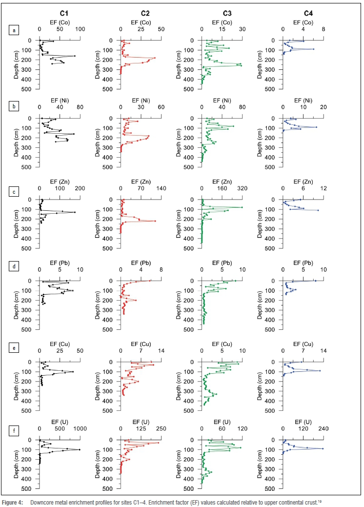
In contrast to the sub-surface enrichments displayed by Co, Ni and Zn, Pb was found at highest concentrations within the upper (<100 cm) sections of the peat sequences (Figure 4d). At the surface, Pb enrichment typically ranged between 6 and 8, showing little lateral variation across the wetland. Cu and U exhibited similar downcore distributions, with highest enrichments typically confined to the upper 100 cm of the peat profiles (Figure 4e,f). Both metals were significantly enriched in C1, with pronounced decreases in concentrations towards the centre of the wetland.
Rare earth element patterns
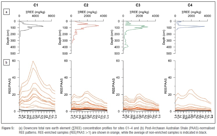
The downcore distributions in ΣREE concentration were remarkably similar across all four profiles (Figure 5a). Highest concentrations were typically confined to a pronounced zone of enrichment between 50 cm and 150 cm. There were modest variations in ΣREE concentration across the wetland, although highest concentrations (~6000 mg/kg) were found in C1. Post-Archaean Australian Shale (PAAS)-normalised patterns indicate that REEs in the upper section of C1 are enriched threefold relative to the other cores (Figure 5b). Enrichment in the middle REEs (MREEs) relative to both the light (LREEs) and heavy REEs (HREEs) is a characteristic across all coring sites.
Discussion
Pollution extent, sources and pathways
The Central Basin extends approximately 55 km, from Durban Roodepoort Deep in the west, where the Main Reef terminates against the Roodepoort Fault, to East Rand Proprietary Mines in the east (Figure 6). Mining operations commenced in 1886, and although the mines started off as separate entities, the underground workings eventually merged over time, forming a continuous mine void extending from the East Rand to the West Rand.7 Large-scale mining began to curtail in the 1950s, with the closure of Durban Roodepoort Deep in 1999 and East Rand Proprietary Mines in 2008 bringing an end to deep-level operations in the basin. A long history of mining operations, together with the progressive closure of mines, has resulted in the wide-scale discharge of contaminants into the streams and watercourses draining the Central Basin.9,10,14
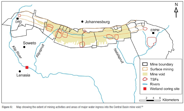
AMD issuing from gold mines on the Witwatersrand is characterised by high concentrations of Ni, Co, Zn and U.23 These metal contaminants enter the river systems through run-off from TSFs as well as through decant of effluent from slimes dams and mine voids. The two streams sampled in this study, the Klip River and Klipspruit, drain the western portion of the Central Basin, where several large mining operations were located, including Durban Roodepoort Deep and Crown Mines (Figure 6). Samples collected from the Klip River and Klipspruit revealed widespread contamination of watercourses in the region. Metal concentrations often exceeded accepted maximum levels, particularly for Al, Fe, Ni and U. Higher concentrations measured in water samples from the Klipspruit compared to the Klip River likely reflect the degree to which the upper reaches of each tributary have been affected by mining. The Klipspruit drains a portion of the Central Basin that has been intensively mined out and which is characterised by the presence of several large TSFs. Interestingly, sediments from the Klip River revealed higher levels of metal enrichment compared to the Klipspruit. To some extent, this appears to reflect differences in the nature of the material analysed, with sediment from the Klip River characterised by substantially lower aluminium concentrations (reflecting a lower clay content) and higher amounts of organic carbon (averaging ~20%) compared to the Klipspruit. Effluent from industrial and residential sources, particularly around Roodepoort and Soweto, may also be a significant contributor to pollutant loads in the Klip River.
Contaminants associated with AMD may also enter the groundwater via seepage through TSFs or directly from flooded mine voids. TSFs on the Witwatersrand are known to be significant contributors to AMD14,24 and often constitute the single largest source of mining-related water pollution24. Tailings material, which is dominated by unconsolidated silicate minerals, is prone to leaching and percolation of rainwater through the dumps, resulting in the formation of polluted groundwater plumes. The geochemical processes characterising Witwatersrand TSFs have been fairly well studied25,26, with the mobility of metals within dumps largely controlled by a combination of pH and redox parameters. Impoundments are generally considered to consist of two key zones -an outer oxidation zone characterised by the presence of sulfate minerals (especially jarosite and gypsum) and secondary oxy-hydroxides, and an inner reduction zone.26
Pyrite on the Witwatersrand is associated with several trace metals found in relatively high concentration, notably Co (1006 mg/kg), Ni (1930 mg/kg) and Zn (90 mg/kg).27 These metals are released during the oxidation process, which also results in the formation of sulfuric acid. Most metals - including Fe, Al, Ni and U - are highly soluble under acidic reducing conditions and are leached from TSFs into the groundwater.
Samples collected from several TSFs located in the Central Basin show that tailings surface material is characterised by several trace metals that are present in elevated concentrations, notably U and Pb (Figure 7). Elevated concentrations of U (up to 5.8%) are a prominent feature of Witwatersrand gold-bearing conglomerates.25 Although originally mined as a by-product of the gold industry, most of the U extracted as part of the gold mining process was dumped in slimes dams on the Witwatersrand.6 Uranium is found in the mineral form uraninite (UO2), which reacts in acidic solutions to produce soluble U4+ ions. Mine dumps thus contain and leach considerable quantities of U, which accumulates in wetlands and river sediments in the region.25,28 Pb is often present in the Witwatersrand conglomerates as galena (PbS), but it also found in association with pyrite.27 Although galena may be oxidised under acidic conditions, Pb is not a notable feature of AMD on the Witwatersrand and has been reported in relatively low concentration (<1 mg/L) within shallow acidic groundwaters.14 This is consistent with Pb enrichments measured in tailings material, suggesting that Pb is present in insoluble oxide and sulfate forms, or absorbed to Fe-(oxy)hydroxides or onto clay minerals, limiting the degree to which it is leached from TSFs. However, several other important metals were either not detected in tailings material (e.g. Ni and Zn) or showed only moderate enrichment (e.g. Al, Fe, Co and Cu). These metals are leached from the tailings under acidic conditions and form the major constituents in seepage from mine dumps on the Witwatersrand.
Acidic seepage from TSFs drains directly into underlying aquifers. Because the Witwatersrand Supergroup lies adjacent to the karstified dolomites of the Malmani Subgroup, seepage from TSFs results in widespread groundwater contamination in the area. Many tailings dumps and slimes dams along the Witwatersrand were purposefully positioned on dolomite to facilitate water drainage, resulting in drier, more stable impoundments.7 Seepage of AMD directly into the karst system below not only results in the contamination of deeper groundwater, but also dissolution of the dolomite.
Neutralisation is likely an important process for metal sequestration and is a common process employed in wetlands constructed for AMD treatment.29,30 The high concentrations of calcium (up to 20%) measured in peat from the Klip River wetland indicate the important role the underlying dolomite substrate likely plays in sequestering metals from groundwater flowing into the wetland. Sulfate salts would be expected to form when sulfuric acid reacts with the alkaline dolomite and the strong relationship between Ca and S abundances suggests the widespread precipitation of gypsum within the wetland. The high metal load carried in the acidic groundwater plumes oxidises and precipitates within the wetland under higher pH (>6) conditions, resulting in substantial peat enrichments, particularly with respect to Ni, Zn, Co and U (Figure 7b).
Variations in pollutant accumulation and sequestration processes
The contamination of both surface water and groundwater discharging from the Central Basin causes pollutants to enter and accumulate in different parts of the Klip River wetland. Contour plots show that metals strongly associated with AMD (Co, Ni and Zn; Figures 8a-c) enter the wetland along the northern edge via groundwater flow and accumulate predominantly within the deeper peat (typically below 1 m). The ingress of these contaminants into the wetland is associated with acidic groundwater plumes, which originate from the numerous TSFs that dominate the Central Rand. Although these contaminants enter the wetland via the same transport processes, their migration and sequestration within the peat is influenced by various physico-chemical factors. Co and Ni show similar distribution patterns (R2=0.73), suggesting that these metals are sequestered via a common mechanism. Humphries et al.9 assessed the partitioning of metals within Klip River sediments and found that Co and Ni were preferentially associated with the reducible (Fe-hydroxides) and oxidisable (organic matter/sulfides) fractions. Zn, which shows no correlation with Co and Ni, is instead predominantly (>50%) associated with Fe-hydroxides9, which precipitate readily under wetland conditions (pH=6-8).
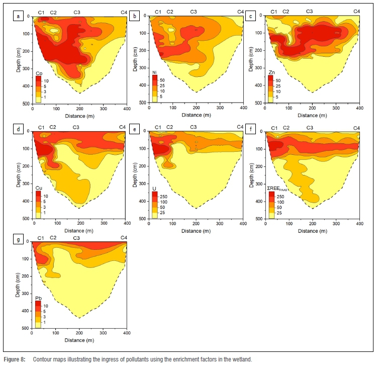
U and Cu exhibit similar distributions (R2=0.76), and although they enter the wetland via the same groundwater process, these metals tend to accumulate predominantly within the upper sediments of the wetland (Figures 8d,f). Cu is primarily associated with the oxidisable fraction9 and it is likely that Cu and U are sequestered as sulfides or bound to organic matter. REEs appear to remain fairly mobile within the peat and migrate laterally across the wetland (Figure 8e). Their sequestration predominantly within the upper 1.5 m is likely associated with Fe-hydroxide adsorption.
Distribution patterns suggest that Pb (Figure 8g) is predominantly unrelated to the ingress of AMD-contaminated groundwater. Instead, localised surface enrichment within the wetland suggests that Pb contamination most likely originates from surface run-off and/or atmospheric fallout. Lead aerosol deposition may be related to historical combustion of Pb-gasoline or dust originating from TSFs31 and other industrial activities.
Summary and conclusions
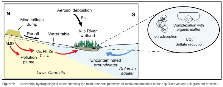
The results of this study reveal the Klip River wetland to be an important sink for pollutants originating from mining activities on the Witwatersrand. Pollutants enter and accumulate within the wetland via different processes, summarised in Figure 9. Most pollutants are likely associated with AMD plumes that emanate from TSFs and enter the wetland via groundwater recharge. This water transports highly elevated concentrations of Co, Ni, Zn and U, which are sequestered within the wetland sediment through a variety of precipitation and adsorption processes. While surface run-off from TSFs severely contaminates watercourses within the upper catchment of the Klip River wetland, surface inputs are considered relatively minor contributors to the overall pollutant load entering the Klip River wetland. Aerosol deposition is, however, likely an important source of Pb.
The extensive accumulation of metals within the Klip River wetland reflects the contaminant legacy associated with gold mining on the Witwatersrand that has spanned over a century. While the efflux of AMD is a particularly difficult and costly problem to control, this study highlights the effectiveness of natural wetlands in trapping vast quantities of toxic pollutants and remediating downstream waters. From this perspective, the Klip River wetlands are undoubtedly some of the most valuable natural assets in Johannesburg. However, wetlands have the potential to release trapped pollutants, particularly if the natural biogeochemical conditions favouring metal sequestration are disrupted. Preventing erosion and further deterioration of the Klip River wetlands is thus critical for the protection of freshwater resources in the region, particularly as the contaminant plumes associated with TSFs will likely persist for decades. Despite 130 years of mining, the Witwatersrand goldfield is still estimated to contain in the order of 30 000 tonnes of gold, representing almost 45% of the world's known gold deposit.32 Although much of this gold is found at depth and in lower-grade narrow reefs, mining and metallurgical advancements could revitalise operations in the future. Under such circumstances, the role of the Klip River wetland in trapping toxic metals emanating from the Central Basin will be critical.
Acknowledgements
The study was supported by research funding awarded to L.P and M.S.H. The South African National Research Foundation provided financial support to S.C. (grant no. 102390). All analyses were conducted at the University of the Witwatersrand, Johannesburg.
Competing interests
We have no competing interests to declare.
Authors' contributions
M.S.H. and L.P. conceptualised the study. S.C. carried out the sample analysis, method validation and data interpretation. All authors were involved in sample collection, data interpretation and writing of the manuscript.
References
1. Tucker RF, Viljoen RR Viljoen MJ. A review of the Witwatersrand Basin -The world's greatest goldfield. Episodes. 2016;39(2):5-33. https://doi.org/10.18814/epiiugs/2016/v39i2/95771 [ Links ]
2. Hobbs PJ, Cobbing JE. Hydrogeological assessment of acid mine drainage impacts in the West Rand Basin, Gauteng Province. Report no. CSIR/NRE/ WR/ER/2007/0097/C. Pretoria: CSIR Natural Resources and the Environment; 2007. [ Links ]
3. McCarthy TS. The decant of acid mine water in the Gauteng city-region -analysis, prognosis and solutions. Provocations Series, Gauteng City-Region Observatory. Johannesburg: University of the Witwatersrand / University of Johannesburg; 2010. [ Links ]
4. McCarthy TS. The impact of acid mine drainage in South Africa. S Afr J Sci. 2011;107(5/6), Art. #712, 7 pages. http://dx.doi.org/10.4102/sajs.v107i5/6.712 [ Links ]
5. Oelofse S. Mine water pollution-acid mine decant, effluent and treatment: A consideration of key emerging issues that may impact the state of the environment. Emerging Issues Paper: Mine Water Pollut. 2008:83-91. [ Links ]
6. Rosner T, Van Schalkwyk A. The environmental impact of gold mine tailings footprints in the Johannesburg region, South Africa. Bull Eng Geol Environ. 2000;59:137-148. http://dx.doi.org/10.1007/s100640000037 [ Links ]
7. Durand JF. The impact of gold mining on the Witwatersrand on the rivers and karst system of Gauteng and North West Province, South Africa. Afr J Earth Sci. 2012;68:24-43. http://dx.doi.org/10.1016/j.jafrearsci.2012.03.013 [ Links ]
8. McCarthy TS, Venter J. Increasing pollution levels on the Witwatersrand recorded in the peat deposits of the Klip River wetland. S Afr J Sci. 2006;10:27-34. [ Links ]
9. Humphries MS, McCarthy TS, Pillay L. Attenuation of pollution arising from acid mine drainage by a natural wetland on the Witwatersrand. S Afr J Sci. 2017;113(1-2):1-9. https://doi.org/10.17159/sajs.2017/20160237 [ Links ]
10. McCarthy TS, Arnold V Venter J, Ellery WN. The collapse of Johannesburg's Klip River wetland. S Afr J Sci. 2007;103(9-10):391-397. [ Links ]
11. Vermaak V. Geomorphological investigation of the Klip River Wetland, South of Johannesburg [MSc dissertation]. Johannesburg: University of the Witwatersrand; 2009. [ Links ]
12. Chinyama A, Ochieng GM, Snyman J, Nhapi I. Occurrence of cyanobacteria genera in the Vaal Dam: Implications for potable water production. Water SA. 2016;42(3):415-420. [ Links ]
13. Abiye TA, Mengistu H, Demlie MB. Groundwater resource in the crystalline rocks of the Johannesburg area, South Africa. J Water Resour Prot. 2011;3(4):199-212. [ Links ]
14. Naicker K, Cukrowska E, McCarthy T. Acid mine drainage arising from gold mine activity in Johannesburg, South Africa and environs. Environ Pollut. 2003;122:29-40. http://dx.doi.org/10.1016/S0269-7491(02)00281-6 [ Links ]
15. Mellor ET. The geological map of the Witwatersrand goldfield (1:60 000). Union of South Africa Department of Mines and Industries geological survey; 1917. [ Links ]
16. Balaram V Rao TG. Rapid determination of REEs and other trace elements in geological samples by microwave acid digestion and ICP-MS. At Spectrosc. 2003;24(6):206-212. [ Links ]
17. Di Bonito M, Breward N, Crout N, Smith B, Young S. Overview of selected soil pore water extraction methods for the determination of potentially toxic elements in contaminated soils: operational and technical aspects. In: De Vivo B, Belkin HE, Lima A, editors. Environmental geochemistry. Amsterdam: Elsevier; 2008. p. 213-249. https://doi.org/10.1016/B978-0-444-53159-9.00010-3 [ Links ]
18. Reimann C, De Caritat P. Distinguishing between natural and anthropogenic sources for elements in the environment: Regional geochemical surveys versus enrichment factors. Sci Total Environ. 2005;337(1-3):91-107. https://doi.org/10.1016/j.scitotenv.2004.06.011 [ Links ]
19. Wedepohl KH. The composition of the continental crust. Geochim Cosmochim Acta. 1995;59(7):1217-1232. https://doi.org/10.1016/0016-7037(95)00038-2 [ Links ]
20. Harikumar PS, Jisha TS. Distribution pattern of trace metal pollutants in the sediments of an urban wetland in the Southwest Coast of India. Int J Eng Sci Technol. 2010;2:840-850. [ Links ]
21. Rudnick RL, Gao S. The crust, composition of the continental crust. In: Holland HD, Turekian KK, editors. Treatise on geochemistry. Oxford: Elsevier; 2003. p.1-64. https://doi.org/10.1016/B0-08-043751-6/03016-4 [ Links ]
22. Holmes S. South African water quality guidelines [document on the Internet]. c1995 [cited 2020 Nov 27]. Available from: https://www.iwa-network.org/filemanager-uploads/WQ_Compendium/Database/Selected_guidelines/041.pdf [ Links ]
23. South African Department of Water Affairs (DWA). Feasibility study for a long-term solution to address the acid mine drainage associated with the East, Central and West Rand underground mining basins. Assessment of the water quantity and quality of the Witwatersrand mine voids. Report no. PRSA000/00/16512/2. Pretoria: DWA; 2012. [ Links ]
24. Tutu H, McCarthy TS, Cukrowska E. The chemical characteristics of acid mine drainage with particular reference to source, distribution and remediation: The Witwatersrand Basin, South Africa as a case study. Appl Geochem. 2008;23(12):3666-3684. http://dx.doi.org/10.1016/j.apgeochem.2008.09.002 [ Links ]
25. Coetzee H, Horstmann U, Ntsume G, Croukamp L. The potential environmental impact of the decant of water from Witwatersrand. Proceedings of the 8th International Congress on Mine Water and the Environment; 2003 Oct 19-22; Johannesburg, South Africa. p. 201-217. [ Links ]
26. Hansen RN. Contaminant leaching from gold mining tailings dams in the Witwatersrand Basin, South Africa: A new geochemical modelling approach. J Appl Geochem. 2015;61:217-223. https://doi.org/10.1016/j.apgeochem.2015.06.001 [ Links ]
27. Barton ES, Hallbauer DK. Trace-element and U-Pb isotope compositions of pyrite types in the Proterozoic Black Reef, Transvaal Sequence, South Africa: Implications on genesis and age. Chem Geol. 1996;133(1-4):173-199. https://doi.org/10.1016/S0009-2541(96)00075-7 [ Links ]
28. Winde F, Sandham LA. Uranium pollution of South African streams - An overview of the situation in gold mining areas of the Witwatersrand. Geo J. 2004;61(2):131-149. https://doi.org/10.1007/s10708-004-2867-4 [ Links ]
29. Skousen J, Zipper CE, Rose A, Ziemkiewicz PF, Nairn R, McDonald LM, Kleinmann RL. Review of passive systems for acid mine drainage treatment. Mine Water Environ. 2017;36:133-153. https://doi.org/10.1007/s10230-016-0417-1 [ Links ]
30. Pat-Espadas AM, Loredo Portales R, Amabilis-Sosa LE, Gómez G, Vidal G. Review of constructed wetlands for acid mine drainage treatment. Water. 2018;10(11), Art. #1685. https://doi.org/10.3390/w10111685 [ Links ]
31. Mathuthu M, Dudu VP Manjoro M. Source apportionment of air particulates in South Africa: A review. Atmos Clim Sci. 2018;9(1):100-113. https://doi.org/10.4236/acs [ Links ]
32. Viljoen M. The life, death and revival of the central Rand Goldfield. Paper presented at: World Gold Conference; 2009 October 26-30; Johannesburg, South Africa. Johannesburg: Southern African Institute of Mining and Metallurgy; 2009. p.131-138. [ Links ]
 Correspondence:
Shaeen Chetty
Email: chettysa18@gmail.com
Received: 20 July 2020
Revised: 27 Nov. 2020
Accepted: 11 Feb. 2021
Published: 29 July 2021
Editor: Yali Woyessa
Funding: South African National Research Foundation (grant no. 102390)
Supplementary Data
The supplementary data is available in pdf: [Supplementary data]

