


Servicios Personalizados
Articulo
 Inglés (pdf)
 Articulo en XML
 Referencias del artículo
Indicadores

Links relacionados
-
 Citado por Google
 -
 Similares en Google
Compartir

 Permalink
South African Journal of Science
versión On-line ISSN 1996-7489
versión impresa ISSN 0038-2353
S. Afr. j. sci. vol.117 no.3-4 Pretoria mar./abr. 2021
http://dx.doi.org/10.17159/sajs.2021/8980
RESEARCH LETTER
New AMS dates for the Middle Iron Age in the Mapungubwe landscape
Thomas N. HuffmanI; Stephan WoodborneI, II
ISchool of Geography, Archaeology and Environmental Studies, University of the Witwatersrand, Johannesburg, South Africa
IIiThemba LABS, Johannesburg, South Africa
ABSTRACT
Research in the Limpopo Valley has documented over 500 Middle Iron Age sites (AD 900-1320) relevant to the origins of Mapungubwe - the capital of the first indigenous state in southern Africa. Fifteen new accelerator mass spectrometry (AMS) dates from 11 of these archaeological sites establish the boundaries of the ceramic facies that form the culture-history framework for such diverse topics as land use, ethnic stratification, population dynamics and rainfall fluctuations. Mapungubwe was abandoned at about AD 1320.
SIGNIFICANCE:
• Because Mapungubwe developed relatively recently (circa AD 1200), it can clarify the origins of older states.
• Environmental factors such as droughts, along with agriculture and trade, played a role in the abandonment of Mapungubwe.
Keywords: abandonment, droughts, ethnic interaction, Mapungubwe landscape, population dynamics
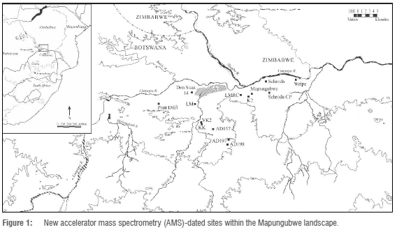
Mapungubwe was the capital of the first indigenous state in southern Africa, laying the foundations for Great Zimbabwe1 (Figure 1). As with states elsewhere, external trade wealth and intensive agriculture were critical agents of change: they helped to transform a ranked-based society with hereditary leadership at the capital K2 into a class-based society with sacred leadership at Mapungubwe.
Archaeologically, Mapungubwe belongs to the Iron Age, a 1500-year long era dominated by Bantu-speaking farmers.2 By convention, archaeologists divide this era into three arbitrary periods: the Early Iron Age (AD 300900), the Middle Iron Age (AD 900-1300) and the Late Iron Age (AD 1300-1840). Characteristic ceramic facies form the basis of the culture-history sequence. Although problematic in terms of real cultural groups, it is another convention to apply the facies name to people who produced the style: thus, Mapungubwe people produced the Mapungubwe style.
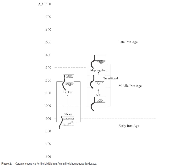
For the origins of Mapungubwe, the most important period is the Middle Iron Age. Stratigraphic relationships for this period have helped to produce a definitive ceramic sequence (Figure 2): it includes the facies known as Zhizo, Leokwe, K2, Transitional K2 (TK2) and Mapungubwe.
Origins of Mapungubwe Project
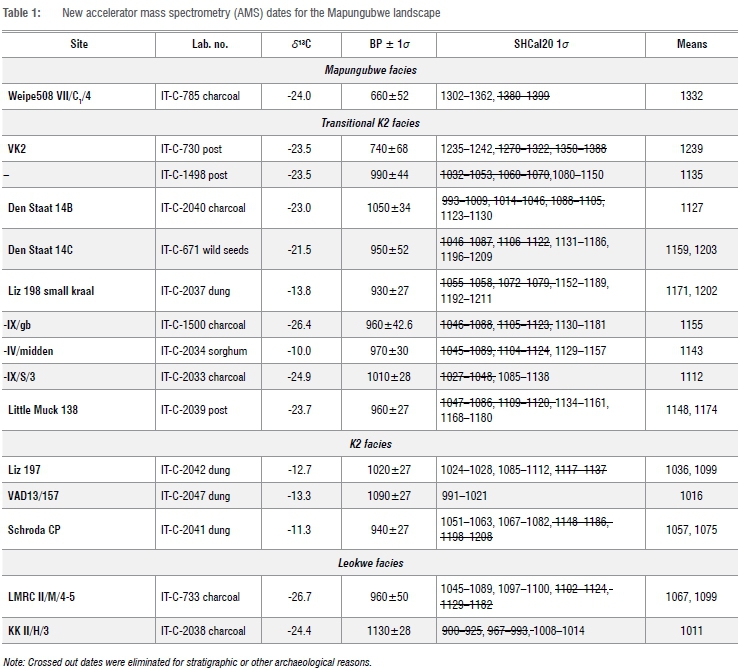
Since 1999, foot surveys in the Mapungubwe National Park and surrounding Buffer Zone have recorded some 1150 Iron Age sites. This large number has helped to clarify different land uses, ethnic stratification, population dynamics and droughts. As part of our project, we have processed 15 new accelerator mass spectrometry (AMS) dates from 11 Middle Iron Age sites and other researchers have produced a few more3-5 (Table 1). We report them here by ceramic facies and research topic.
For Table 1, we first calibrated the BP (Before Present) dates using Calib 8.10 and the Southern Hemisphere data set (SHCal20) using Stuiver and Reimer6 and Hogg et al.7 This calibration programme includes the median age for the radiocarbon date, but this often falls outside the 1-sigma range.
Furthermore, the radiocarbon curve fluctuates markedly during the Middle Iron Age, so that one radiocarbon result may have two or more possible calendar dates. To help choose between different calibration spans, we consider the midpoints of the 1-sigma ranges along with the known stratigraphic sequence and then order the possibilities. Thus, a hypothetical date of BP 1000±1 calibrates to AD 1033-1048 for sites with K2 ceramics but to AD 1120-1137 for the TK2 facies.
The Middle Iron Age
According to isotopic analysis, when Zhizo people moved into the Limpopo Valley from southwest Zimbabwe at about AD 900, the climate was similar to that today.8 This means that Zhizo people would have found farming difficult, and some other reason probably accounts for their presence. Ivory artefacts and imported glass beads at Schroda9,10 and the locations of other Zhizo sites1 indicate that these people may have purposefully moved into the basin to hunt elephants for the ivory trade.
Land use
At about AD 1000, or slightly later, Leopard's Kopje people established their capital at the site K2 near the Shashe-Limpopo confluence in South Africa.11 In contrast to the earlier Zhizo phase, Leopard's Kopje people began to cultivate the margins of the large vlei there (Figure 1).
Models of vlei and riverbed cultivation in Zimbabwe12 suggest that they planted sorghums in the rich loams along the wet edges and millets on the sandy fluvial terraces.13,14 In typical farming homesteads, many grainbin foundations encircle a central cattle kraal (e.g. Liz 197: IT-C-2042; Edmondsberg 157: IT-C-2047). Besides these homesteads, some settlements were cattle posts located on spurs near springs on the escarpment, or otherwise well away from agricultural land (e.g. on Schroda: IT-C-2041). In addition, field camps were located near agricultural land but on small hills and rises in situations unsuitable for settled villages: they have granaries, small stock kraals and middens, but lack permanent housing and cattle kraals. Rainmaking hills are a fourth kind of site.5,15
Ethnic interaction
When K2 people took over the valley, many Zhizo people went west to Botswana to become the Toutswe group.16 Some Zhizo people, however, stayed behind to live within the K2 interaction sphere.17,18 Because their ceramic style has changed somewhat, it is called Leokwe after the hill where it was first recognised. A Leokwe site in the Venetia Reserve, KK110, upstream of the vlei, has been AMS dated (IT-C-2038) to the 10th century, somewhat earlier than most dates. Antonites3 added three new dates for the Leokwe levels at Schroda, one of which is also early.
These dates show that Zhizo ceramics began to change into Leokwe when Leopard's Kopje people first moved into the valley. This contact represents the first 'ethnic stratification'19 during the Iron Age in southern Africa. The new dates and ceramic analyses show that this relative status started at the beginning of contact, contra some interpretations.17
Although under the political authority of K2, Leokwe people maintained their own material-culture signature for several decades. It is common in such situations for earlier people to assume ritual roles: this gives them respect but not political power.20 Among other tasks, Leokwe people probably supervised the initiation school21 at Schroda.
Besides ritual specialists, Leokwe people appear to have herded cattle for K2 elite, as several Leokwe settlements have 'extra' kraals.22 A large Leokwe complex (2229AB223/224) inside the National Park yielded a mid- to late-11th century date from the main midden (IT-C-733), placing it in the mid-K2 phase.
Universally, states tend to subsume ethnic differences in favour of a national identity. In this regard, a few Leokwe vessels occur in K2 and TK2 sites (presumably through marriage alliances), but not in Mapungubwe. A national identity thus appears to have replaced ethnic differences by the early-13th century when large-scale centralised authority was established, but before sacred leadership had fully materialised.
Population dynamics
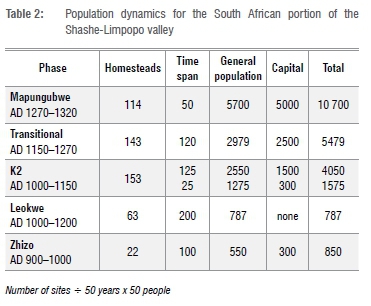
As the state grew, so did populations. For population estimates, we need accurate spans for each facies. Until now, the boundary between K2 and TK2 has been unclear. Carbonised seeds from Den Staat 14C (IT-C-671), along with dates from Liz198 (IT-C-1500, IT-C-2033, IT-C-2034 and IT-C-2037), a burnt hut on Little Muck (IT-C-2039) and a burnt granary at VK2 (IT-C-1498) together show that K2 ceramics transformed into TK2 around AD 1150. TK2 in turn became Mapungubwe about 120 years later, while Mapungubwe pottery lasted for about 50 years.
Using these new time spans, we assign 50 people (half of them adults) to each homestead, based on the Middle Iron Age burials at Kgaswe16 in Botswana. We then assign 50 years duration to each homestead and divide the time span of each facies, and population, by the number of 50-year units. Thus, if 7650 K2 people (153 x 50) lived in the valley, then 2550 people (7650 h 3) lived there at any one time. This formula determines general populations in relative terms rather than as an absolute census. In addition to ordinary people, total populations need to include the capitals (Schroda, K2 and Mapungubwe). It is likely, however, that K2 started as a small capital before reaching its maximum extent. We thus present the first 25 years of its lifespan as one half of a 50-year unit (2550 / 2 = 1275 people) and then calculate the remaining population (7650 - 1275 = 6375 people) and duration minus that amount (150 - 25 = 125 years). Whatever formula is used, the K2 population was larger than Zhizo and over 10 000 people lived in the valley during the Mapungubwe phase (Table 2).
Droughts and abandonment
Rainfall affected political stability as well as agricultural production. We know that some farmers burnt their grainbins as a ritual of cleansing related to severe drought (3-5 years in a row).23 We first used the traditional radiocarbon method to date the burnings and droughts but fluctuations in the calibration curve confounded the results. We later added detailed baobab data (based on the isotopic component of successive growth rings)24,25 that eliminate the multiple choices in the calibration curves. These data reveal a few droughts not previously noted (Table 3). One drought (Group IX) in particular contributed to the abandonment of Mapungubwe. The baobab sequence dates this important episode somewhat later than expected, to about AD 1310±5.
Following the principles of sacred leadership, the leader's right to rule would have been questioned as a result of this drought.12 With Mapungubwe leadership in turmoil, Great Zimbabwe was able to seize control of the gold belt, the most important source of trade wealth, and Great Zimbabwe became the new centre of power. Thus, the 14th-century drought was an indirect cause of Mapungubwe's abandonment.
Dates from Weipe508 (IT-C-785, BP 650±52; and Pta-9549, BP 630±70) show that Mapungubwe people remained in the valley until about AD 1320 - the same date as the drought.
Acknowledgements
We thank John Calabrese, Kerry Fatherley, Myra Mashimbye, McEdward Murimbika, Justine du Piesanie, Alex Schoeman, Jeannette Smith, Peter Venter, Jaco van der Walt and Marilee Wood for their help with the surveys, excavations and specialist studies. The University of the Witwatersrand Honours classes of 2000 to 2009 also participated in the research. Wendy Voorvelt prepared the illustrations and Moshabi Silidi and Stephan Winkler processed the AMS dates. Fieldwork was sponsored by Archaeological Resources Management and the University of the Witwatersrand Research Incentive Scheme (HUFF013) and the South African National Research Foundation (85983).
Competing interests
We have no competing interests to declare.
Authors' contributions
T.N.H. directed the field work and S.W. the AMS dating. Both authors prepared the manuscript.
References
1. Huffman TN. Mapungubwe and the origins of the Zimbabwe culture. In Leslie M, Maggs T, editors. African Naissance: The Limpopo Valley 1 000 years ago. S Afr Archaeol Soc Goodwin Series 8. 2000. p. 14-29. https://doi.org/10.2307/3858043 [ Links ]
2. Huffman TN. Handbook to the Iron Age: The archaeology of pre-colonial farming societies in southern Africa. Pietermaritzburg: University of KwaZulu-Natal Press; 2007. [ Links ]
3. Antonites AR. A revised chronology for the Zhizo and Leokwe horizons at Schroda. South Afr Humanities. 2018;31:223-246. [ Links ]
4. Manyanga M. Resilient landscapes: Socio-environmental dynamics in the Shashi-Limpopo Basin, Southern Zimbabwe c. AD 800 to the present. Studies in Global Archaeology 11. Uppsala: Department of Archaeology and Ancient History; 2007. [ Links ]
5. Schoeman MH. Excavating the 'waterpits in the mountain': The archaeology of Shashe-Limpopo Confluence Area rain-hill rock tanks. South Afr Humanities. 2009;21:275-298. [ Links ]
6. Stuiver M, Reimer PJ. Extended 14C radiocarbon data base and revised CALIB 3.0 14C age calibration program. Radiocarbon. 1993;35(1):215-230. https://doi.org/10.1017/S0033822200013904 [ Links ]
7. Hogg AC, Hua Q, Palmer JG, Turney CSM, Southon J, Bayliss A, et al. SHCal20 Southern hemisphere calibration, 0-55,000 years cal BP. Radiocarbon. 2020;62(4):759-778. https://doi.org/10.1017/RDC.2020.59 [ Links ]
8. Smith J, Lee-Thorp J, Hall S. Climate change and agropastoralist settlement in the Shashe-Limpopo River Basin, southern Africa: AD 880 to 1700. S Afr Archaeol Bull. 2007;62:115-125. [ Links ]
9. Voigt EA. Mapungubwe: An archaeozoological interpretation of an Iron Age community. Museum Monograph 1. Pretoria: Transvaal Museum; 1983. [ Links ]
10. Wood M. A glass bead sequence for southern Africa from the 8th to the 16th century AD. J Afr Archaeol. 2011;9(1):67-84. https://doi.org/10.3213/1612-1651-10184 [ Links ]
11. Meyer A. The archaeological sites of Greefswald: Stratigraphy and chronology of the sites and a history of investigations. Pretoria: University of Pretoria; 1998. [ Links ]
12. Murimbika MT. Sacred powers and rituals of transformation: An ethnoarchaeological study of rainmaking rituals and agricultural productivity during the evolution of the Mapungubwe state, AD 1000 to AD 1300 [dissertation]. Johannesburg: University of the Witwatersrand; 2006. [ Links ]
13. Huffman TN. Test excavations at Liz 197: A K2-period homestead in the Limpopo Valley. South Afr Humanities. 2016;28:135-152. [ Links ]
14. Huffman TN. Origins of Mapungubwe Project: Test excavations at Den Staat 14B and 14C. South Afr Humanities. 2017;30:185-194. [ Links ]
15. Schoeman MH. Imagining rain-places: rain-control and changing ritual landscapes in the Shashe-Limpopo Confluence Area, South Africa. S Afr Archaeol Bull. 2006;61:152-165. https://doi.org/10.2307/20474923 [ Links ]
16. Denbow JR. A new look at the later prehistory of the Kalahari. J Afr Hist. 1986;27:3-29. https://doi.org/10.1017/S0021853700029170 [ Links ]
17. Calabrese JA. The emergence of social and political complexity in the Shashi-Limpopo Valley of southern Africa, AD 900 to 1300: Ethnicity, class, and polity. BAR International Series 1617. Cambridge Monographs in African Archaeology 69. Oxford: Archaeopress; 2007. https://doi.org/10.30861/9781407300290 [ Links ]
18. Huffman TN. Leokwe and K2: Ethnic stratification during the Middle Iron Age in Southern Africa. J Afr Archaeol. 2007;5(2):3-27. https://doi.org/10.3213/1612-1651-10091 [ Links ]
19. Hammond-Tooke WD. Ethnicity and ethnic group in Iron Age southern Africa. S Afr J Sci. 2000;96(8):421-l22. [ Links ]
20. Kopytoff I. The African frontier: The reproduction of traditional African societies. Bloomington, IN: Indiana University Press; 1989. [ Links ]
21. Van Schalkwyk JF, Hanisch EOM, editors. Sculptured in clay: Iron Age figurines from Schroda, Limpopo Province, South Africa. Pretoria: National Culture History Museum; 2002. p. 21-39. [ Links ]
22. Huffman TN. Salvage excavations on Greefswald: Leokwe commoners and K2 cattle. South Afr Humanities. 2014;26:101-128. [ Links ]
23. Huffman TN. A cultural proxy for drought: Ritual burning in the Iron Age of southern Africa. J Archaeol Sci. 2009;36:991-1005. https://doi.org/10.1016/j.jas.2008.11.026 [ Links ]
24. Woodborne S, Hall G, Robertson I, Patrut A, Rouault M, Loader N, et al. 1000-year carbon isotope rainfall proxy record from South Africa baobab trees (Adansonia diagata L). PLoS ONE. 2015;10(5), e0124202. https://doi.org/10.1371/journal.pone.0124202 [ Links ]
25. Huffman TN, Woodborne S. Archaeology, baobabs and drought: Cultural proxies and environmental data from the Mapungubwe landscape. Holocene. 2016;26(3):464-470. https://doi.org/10.1177/0959683615609753 [ Links ]
 Correspondence:
Thomas Huffman
Email: thomas.huffman@wits.ac.za
Received: 07 Oct. 2020
Revised: 09 Nov. 2020
Accepted: 09 Nov. 2020
Published: 29 Mar. 2021
Editors: Margaret Avery
Funding: Archaeological Resources Management, University of the Witwatersrand Research Incentive Scheme (HUFF013), South African National Research Foundation (85983)

