


Services on Demand
Article
 English (pdf)
 Article in xml format
 Article references
Indicators

Related links
-
 Cited by Google
 -
 Similars in Google
Share

 Permalink
South African Journal of Science
On-line version ISSN 1996-7489
Print version ISSN 0038-2353
S. Afr. j. sci. vol.117 n.1-2 Pretoria Jan./Feb. 2021
http://dx.doi.org/10.17159/sajs.2021/8515
COMMENTARY
Engagement for airborne geophysical survey within a transdisciplinary baseline programme in the Eastern Cape Karoo
Barry MorkelI, II; Moctar DoucouréI, III; Martin BentleyI, III; Divan StroebelI, III; Maarten de WitI
IAfrica Earth Observatory Network (AEON)-Earth Stewardship Science Research Institute (ESSRI), Nelson Mandela University, Port Elizabeth, South Africa
IIDepartment of History and Political Studies, Nelson Mandela University, Port Elizabeth, South Africa
IIIDepartment of Geosciences, Nelson Mandela University, Port Elizabeth, South Africa
Keywords: engaged scholarship, airborne geophysical survey, Karoo shale gas, baseline research, social licence
The biggest lesson from the recent shale gas boom in the USA - specifically in relation to monitoring and mitigating contamination of water, and community health impacts reported in receiving communities, such as the Marcellus shale regions of Pennsylvania - is the fundamental need for baseline studies prior to any proposed shale gas development.1(p.547) The USA is the largest (shale) gas producer and exporter to the European Union (EU) but it is generally accepted that, in most of the basins and shale plays in the USA in which unconventional oil and gas development has occurred, baseline studies have not been implemented.2(p.40) This phenomenon, along with its environmental monitoring and regulatory implications, led to the establishment of the Karoo Shale Gas Baseline Programme, undertaken by the Africa Earth Observation Network (AEON) - Earth Stewardship Science Research Institute (ESSRI), hereon refered to as AEON, in partnership with the Eastern Cape Provincial Government. The Programme was the first of its kind in South Africa, and produced a transdisciplinary baseline of the Karoo prior to any shale gas development in the Basin.
A report by AEON summarises 4 years of baseline data collection and analyses, and shows that all aspects of life and natural systems in the Karoo could be affected by shale gas development. To provide this data, AEON research teams from Nelson Mandela University conducted groundwater hydrocensus and sampling for chemical analysis, surface water studies and ecosystems analysis, micro-seismicity measurements, and methane gas analysis, socio-economic research, and citizen science.3
As the great shale gas debate4 affects all inhabitants of the Karoo, including farmers, landowners and residents in Karoo towns, permission to conduct natural baseline research calls for meaningful consultation involving deliberate engagement with affected communities based on information sharing, and responsiveness to the specific issues raised by local stakeholders in the process. This process requires greater transparency and trust building than has been evident in the overall Karoo shale gas development process to date.3-6 Difficulties include the application and utilisation of new and/or relatively unfamiliar data gathering methods and technologies, including fixed-wing airborne and unmanned aerial vehicle (UAV or drone) observations within an environment already experiencing considerable uncertainty and trust deficit amongst many stakeholders.
The focus of this Commentary is stakeholder consultation as well as operational and logistical resilience, both in the field and behind the scenes, that have been necessary to conduct an airborne survey in the Karoo.
Landowner suspicions and trust building
Much of our ground and geophysical baseline data sets cover an area near the Eastern Cape Karoo town of Jansenville, a region of the semi-arid Karoo colloquially referred to as the Noorsveld, located 190 km to the north of Port Elizabeth. This area was prioritised mainly due to groundwater and logistical considerations, as well as previous scientific research undertaken by the group, which included studies of black shales from drillholes, deep conductive layer and velocity anomalies.7-9 This led to the deployment of different geophysical methods aimed at better quantifying the deep subsurface, such as magneto-telluric surveys conducted in partnership with the GFZ-Potsdam3, and the application of a novel passive seismic technique (i.e. no induced energy) which was only available through AEON-ESSRI at the time. Airborne data collection was necessary in order to bridge the gap between surface and deep subsurface geophysics.
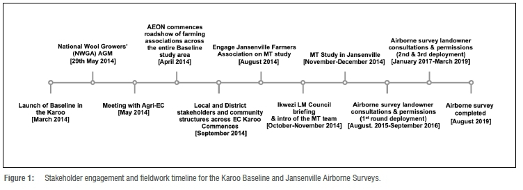
AEON had developed considerable experience in the area through related baseline studies and field work conducted since mid-2014. These studies were dependent on a productive working relationship with stakeholders, including the local municipality, relevant provincial government departments (through their regional offices located either in Jansenville or Graaff-Reinet) as well as the local business and farming community.
Initial consultations in the survey area primarily focused on providing the local stakeholders of the then Ikwezi Local Municipality (an area now located within the larger Dr Beyers Naude Local Municipality) with an introduction to the Karoo Shale Gas Baseline Research Programme, in order to facilitate initial access to various study sites around the Karoo (see timeline in Figure 1). In Jansenville and across the Noorsveld, prior to commencing with airborne geophysics, the group had already conducted numerous baseline studies, with some still ongoing at the time, including a groundwater survey of 52 boreholes3,10, a magneto-telluric ground survey3,8, surface ecosystems monitoring in water bodies and termite mounds3,11-13, micro-earthquake surveys5,9, as well as a household survey13 in and around Jansenville. On implementation of the magneto-telluric survey, a year before commencing preparations for the airborne geophysics, the team convened separate meetings with local farmers' associations, the Ikwezi Municipal Council and senior officials, to inform them in greater detail of the need for the magneto-telluric study and to officially welcome visiting German science collaborators (magneto-telluric survey team) from the GFZ-Potsdam. The team relied heavily on the knowledge and experience of the local farmers' associations (Jansenville, Klipplaat and Waterford) in identifying the many landowners and obtaining their contact details, so as to facilitate direct contact with the individuals involved. Two retired farmworkers, who are familiar with the terrain, assisted the ground team in navigating between the various farms. These contacts proved essential during the roll-out of the magneto-telluric survey in late 2014, because it required extensive interaction with farmers and landowners in gaining access to farms within the study area, and laid a strong foundation for the airborne survey.
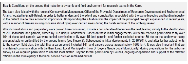
Using the same strategies adopted for the smaller magneto-telluric survey, the ground team conducted a farm-to-farm campaign as best as it could. In instances in which the farmer or landowner did not attend our meetings, which were convened with farm associations in the District, the team visited the farm in person or phoned the owner to let them know of the survey and to obtain permission to fly over their property. Owing to the complex nature of landownership, land tenure, land use patterns and agricultural activities in the district, the team encountered a number of unforeseen challenges, and learned lessons along the way. In addition to these difficulties related to contacting landowners, areas to be avoided had to be identified. These ultimately resulted in exclusions and avoidances on the survey flight plan so as to avoid negative impacts on the ground. We had to avoid pre-identified areas related to livestock farming (mainly linked to lambing season), wildlife and game breeding (including for hunting and eco-tourism), as well as chicken and ostrich farms because these were sensitive for a number of farmers and landowners. While these presented difficulties for the permission process, these challenges were overcome by the team undertaking 'ground-truthing' missions and plotting coordinates at specific camps and sites in collaboration with landowners who had identified areas of sensitivity, which were excluded from the survey flight plan. This collaboration between ground teams and landowners ultimately resulted in the survey being successfully flown over 141 land parcels (refer to Box 1).
Operationalising the airborne survey in the Karoo
Survey flying commenced in October 2016 with the use of a gyrocopter. The team decided that a gyrocopter was the platform of choice because it is less invasive, with little disturbance on the ground, whilst maintaining fuel efficiency. The initial plan was to collect data by flying at an altitude of approximately 40 m, across a grid of N-S flight lines spaced 200 m apart at a speed of 80 km/h. Shortly after commencement, and on review of the initial data collected, flights were suspended owing to strong winds together with the effects of thermal lift during the Karoo's summer months, which had impacted data quality negatively. The survey recommenced in April 2017; this was also cut short after the airborne team experienced a technical malfunction with the aircraft which was left irreparable after an emergency landing.
Given the difficulty in sourcing a replacement gyrocopter, it was then decided to use a fixed-wing Maule Bush aircraft which offered greater stability in the air. However, this new aircraft necessitated further consultation and communication on the ground. An advertisement was published in the local newspaper, the Graaff-Reinet Advertiser, and posters were displayed at high visibility sites in Jansenville (library, police stations, shops, municipal offices and local farmers' cooperative). The decision was also taken to re-schedule flying for cooler winter months, thereby ensuring more favourable wind conditions for better data quality.
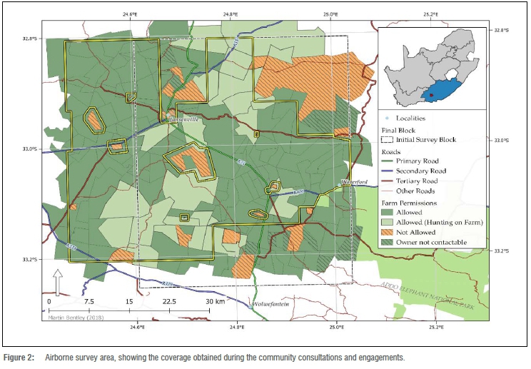
The first deployment of the fixed-wing aircraft was cut short in 2018 by damage to an essential sensor. The team then finally began the survey again in June 2019. To avoid those areas identified as 'Not allowed' and 'Owner not contactable' (Figure 2), the airborne team had to implement necessary technical measures during planning and the flight itself. Similarly, over farms where it was known that hunting occurred (see Box 1), the height above the ground was increased to 80 m because flying continued during the colder hunting season in the Karoo. While the increase in flight height above ground had the effect of lowering the spatial definition of detectable magnetic features, the gaps in the survey coverage mean that some subtle local structures were unavailable to the interpreter of the geophysical image.
Conclusion
The survey, which was eventually concluded in August 2019, has contributed valuable geophysical data to the Karoo baseline study. In addition, the team learnt about negotiating with landowners, farmers and other stakeholders whilst preparing to undertake this airborne survey. In particular, we were aware of the context of distrust that is connected with any research relating to shale gas in the Karoo.
We have shown that permitting for geophysical airborne surveys in the Karoo requires trust building through engagement, and responsiveness to the sensitivities and issues raised by stakeholders in the area. Participatory science, in the form of citizen science, can also prove a significant contribution to trust building. More fundamentally, the operationalisation of airborne surveys in the Karoo as part of the broader natural baseline study has shown that any future exploration for shale gas in the Karoo would require a social licence to operate, which will be reliant on significantly higher levels of consultation and trust building. In the Karoo, where the latter is in short supply, the prevailing trust deficit will only be overcome through honest, open and responsive communication with interested and affected parties moving forward.
During the compilation of this article, one of the authors, AEON Science Director and mentor, Prof. Maarten de Wit, passed away. His passion for science and innovation in fieldwork and data collection through the application of new technologies in the Karoo has been groundbreaking. Similarly, his respect and genuine concern for the people of the Karoo was translated into their inclusion and participation becoming central to the baseline study.
Acknowledgements
This engagement work was made possible by funding from the Eastern Cape Provincial Government, and from the NRF/DSI through Iphakade. The airborne survey was conducted by GyroLAG. This is AEON publication number 198.
Competing interests
We declare that there are no competing interests.
References
1. King R. We need a fracking baseline. La L Rev. 2016;77(2), Art. #12. Available from: https://digitalcommons.law.lsu.edu/lalrev/vol77/iss2/12 [ Links ]
2. US Environmental Protection Agency. Hydraulic fracturing for oil and gas: Impacts from the hydraulic fracturing water cycle on drinking water resources in the United States. Executive summary. EPA/600/R-16/236ES. Washington DC: Office of Research and Development; 2016. Available from: https://www.epa.gov/hfstudy/executive-summary-hydraulic-fracturing-study-final-assessment-2016 [ Links ]
3. AEON-ESSRI Research Group. (T)(C)racking the shale-gas debate: Baseline data and citizen science. Port Elizabeth: Africa Earth Observatory Network (AEON), Nelson Mandela University; 2018. Available from: https://aeon.org.za/wp-content/uploads/2018/12/AEON-Shale-Gas-Report-2018.pdf [ Links ]
4. De Wit MJ. The great shale debate in the Karoo. S Afr J Sci. 2011;107(7-8), Art. #791. https://doi.org/10.4102/sajs.v107i7/8.791 [ Links ]
5. Academy of Science of South Africa (ASSAf). South Africa's technical readiness to support the shale gas industry. Pretoria: ASSAf; 2016. http://dx.doi.org/10.17159/assaf.2016/0003 [ Links ]
6. Morkel B, De Wit MJ. Trying not to repeat history: Are shale gas development and broad-based economic development compatible? In: Gamper-Rabindran S, editor. The shale dilemma: A global perspective on fracking and shale development. Pittsburgh, PA: University of Pittsburgh Press; 2018. p. 342378. [ Links ]
7. Geel C, Schulz HM, Booth P De Wit M, Horsfield B. Palaeo-environment, diagenesis and characteristics of Permian black shales in the Lower Karoo Supergroup flanking the Cape Fold Belt near Jansenville, Eastern Cape, South Africa: Implications for the shale gas potential of the Karoo Basin. S Afr J Geol. 2015;118(3):249-274. https://doi.org/10.2113/gssajg.118.3.249 [ Links ]
8. Weckmann U, Jung A, Branch T, Ritter O. Comparison of electrical conductivity structures and 2D magnetic modelling along two profiles crossing the Beattie Magnetic Anomaly, South Africa. S Afr J Geol. 2007;110(2-3):449-164. https://doi.org/10.2113/gssajg.110.2-3.449 [ Links ]
9. Bezuidenhout L, Mordret A, Doucouré M, Lecocq T, Brenguier F, Wagner V et al. Rayleigh group velocity extraction from ambient seismic noise to map the south Eastern Cape Karoo region. S Afr J Geol. 2017;120:341-350. https://doi.org/10.25131/gssajg.120.3.341 [ Links ]
10. Stroebel DH, Thiart C, De Wit MJ. Towards defining a baseline status of scarce groundwater resources in anticipation of hydraulic fracturing in the Eastern Cape Karoo, South Africa: Salinity, aquifer yields and groundwater levels. In: Ofterdinger U, Macdonald AM, Comte JC, Young ME, editors. Groundwater in fractured bedrock environments. Geological Society, London, Special Publications. 2018;479:129-145. https://doi.org/10.1144/SP479.3 [ Links ]
11. Mabidi A, Bird MS, Perissinotto R. Assessment of the physicochemical characteristics of surface waterbodies in a region earmarked for shale gas exploration (Eastern Cape Karoo, South Africa). Mar Freshwater Res. 2017;68(9):1626-1641. https://doi.org/10.1071/MF16102 [ Links ]
12. Mabidi A, Bird MS, Perissinotto R. Distribution and diversity of aquatic macroinvertebrate assemblages in a semi-arid region earmarked for shale gas exploration (Eastern Cape Karoo, South Africa). PLoS ONE. 2017;12(6), e0178559. https://doi.org/10.1371/journal.pone.0178559 [ Links ]
13. Linol B, Miller W, Rensburg C, Schoeman R, Bezuidenhout L, Genin F, et al. Earth stewardship science - Transdisciplinary contributions to quantifying natural and cultural heritage of southernmost Africa. Remote Sens. 2020;12(3):420. https://doi.org/10.3390/rs12030420 [ Links ]
 Correspondence:
Barry Morkel
Email: barry.morkel@mandela.ac.za
Published: 29 January 2021

