


Services on Demand
Article
 English (pdf)
 Article in xml format
 Article references
Indicators

Related links
-
 Cited by Google
 -
 Similars in Google
Share

 Permalink
South African Journal of Science
On-line version ISSN 1996-7489
Print version ISSN 0038-2353
S. Afr. j. sci. vol.117 n.1-2 Pretoria Jan./Feb. 2021
http://dx.doi.org/10.17159/sajs.2021/8134
COMMENTARY
Snapshot Safari: A large-scale collaborative to monitor Africa's remarkable biodiversity
Lain E. PardoI, VI; Sara BombaciII; Sarah E. HuebnerIII; Michael J. SomersIV, V; Herve FritzI, VI; Colleen DownsVII; Abby GuthmannIII; Robyn S. HetemVIII; Mark KeithIV; Aliza le RouxIX, X; Nokubonga MgqatsaXI; Craig PackerIII; Meredith S. PalmerXII; Daniel M. ParkerIX, XIII; Mike PeelVII, XIV, XV; Rob SlotowVII; W. Maartin StraussI, VI; Lourens SwanepoelXVII, I, VIII; Craig TamblingXIX; Nairobi TsieIV; Mika VermeulenI, VI; Marco WilliXX; David S. JachowskiVII, XXI; Jan A. VenterI, VI
ISchool of Natural Resource Management, Nelson Mandela University, George, South Africa
IIDepartment of Fish, Wildlife, and Conservation Biology, Colorado State University, Fort Collins, Colorado, USA
IIICollege of Biological Sciences, University of Minnesota, St. Paul, Minnesota, USA
IVEugène Marais Chair of Wildlife Management, Mammal Research Institute, Department of Zoology and Entomology, University of Pretoria, Pretoria, South Africa
VCentre for Invasion Biology, University of Pretoria, Pretoria, South Africa
VIREHABS, International Research Laboratory, French National Centre for Scientific Research (CNRS) / University of Lyon 1 / Nelson Mandela University, George, South Africa
VIISchool of Life Sciences, University of KwaZulu-Natal, Durban, South Africa
VIIISchool of Animal, Plant and Environmental Sciences, University of the Witwatersrand, Johannesburg, South Africa
IXDepartment of Zoology and Entomology, University of the Free State, Phuthaditjhaba, South Africa
XAfromontane Research Unit, University of the Free State, Phuthaditjhaba, South Africa
XIWildlife and Reserve Management Research Group, Department of Zoology and Entomology, Rhodes University, Makhanda, South Africa
XIIDepartment of Ecology and Evolutionary Biology, Princeton University, Princeton, New Jersey, USA
XIIISchool of Biology and Environmental Sciences, University of Mpumalanga, Mbombela, South Africa
XIVAgricultural Research Council, Animal Production Institute, Rangeland Ecology, Pretoria, South Africa
XVApplied Behavioural Ecology and Ecosystems Research Unit, University of South Africa, Johannesburg, South Africa
XVIDepartment of Environmental Sciences, University of South Africa, Johannesburg, South Africa
XVIIDepartment of Zoology, University of Venda, Thohoyandou, South Africa
XVIIIAfrican Institute for Conservation Ecology, Makhado, South Africa
XIXDepartment of Zoology and Entomology, University of Fort Hare, Alice, South Africa
XXSchool of Physics and Astronomy University of Minnesota, Minneapolis, Minnesota, USA
XXIDepartment of Forestry and Environmental Conservation, Clemson University, Clemson, South Carolina, USA
Keywords: citizen science, camera trap, conservation, machine learning, mammals
Nature is experiencing degradation and extinction rates never recorded before in the history of Earth.1,2 Consequently, continuous large-scale monitoring programmes are critical, not only to provide insights into population trends but also to aid in understanding factors associated with altering population dynamics at various temporal and spatial scales.3 Continuous monitoring is important not only for tracking rare or threatened species but also to detect the increase of potentially invasive species4, and the trends in the populations of common species, which in some regions are declining even more rapidly than are rare species2.
The combination of citizen science and cutting-edge technologies has improved monitoring programmes.5 In this regard, camera traps have become a popular tool to engage with society while obtaining accurate scientific data.3 The importance of advances in technological monitoring has even been highlighted by the United Nations Environment Programme (UNEP) through the proposed 'Digital Ecosystem framework', a complex distributed network or interconnected socio-technological system.6
Monitoring species and ecosystems is critical to Africa - a highly biodiverse continent with numerous mammal species threatened by human activities such as poaching, overhunting, and climate and land-use change.7 Over half the terrestrial mammals in Africa have experienced range contractions of as much as 80% on average, including predator species such as lions (Panthera leo) and large ungulates.2 In sub-Saharan Africa, human impacts are projected to increase, and trigger an increased extinction risk.7 However, information on the conservation status of many species is limited, and many areas in Africa lack the baseline biodiversity data necessary to assess the outcomes of existing conservation programmes.5 Further, the lack of standardised methods to assess biodiversity patterns limits our ability to detect and respond to changes in mammal populations caused by environmental and anthropogenic factors.8
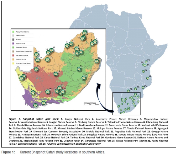
In attempting to address some of the above challenges, we have formed the Snapshot Safari Network (www.snapshotsafari.org) - a large-scale international camera trap network to study and monitor the diversity and ecological dynamics of southern and eastern African mammals. Snapshot Safari (hereafter Snapshot) is one of the largest camera trap networks in the world. It began in 2010 with a single camera trap grid in Serengeti National Park, Tanzania9, and the model and protocols have since been expanded in Tanzania as well as into five other countries: Botswana, Kenya, Mozambique, South Africa, and Zimbabwe (Figure 1). Participating locations represent a wide variety of habitats, wildlife communities, management types and protected area sizes. Here, we introduce this multidisciplinary initiative which combines citizen science and advanced machine learning techniques for the analysis of millions of animal photographs. We also introduce a set of high priority research questions emanating from expert consultation in 2019.
Standardised methods
Our camera trap design consists of regular grids of 5 km2 per location (grid sites). Each grid has 8 to 245 camera traps depending on the objectives and area to cover. Cameras are secured with steel cases and fixed at ~50 cm height to detect medium- to large-bodied mammals. Each camera is programmed to take a series of three images within 1-5 seconds of each other (a 'capture event') when passive infrared sensors are triggered by motion or heat during the day and one image at night.9 Most grids have operated continuously since 2018and are intended to run for a decade or longer. Data collected are forwarded to the University of Minnesota Lion Center for curation and management of the citizen science component. Metadata on camera placements and habitat characteristics are also collected in a standardised manner to facilitate cross-site comparisons.
Camera traps generate large volumes of photographs which makes the classification of species a time-consuming task. To facilitate efficient image processing, we combine citizen science efforts with advanced machine learning techniques.10 Snapshot partners with the citizen science platform www.zooniverse.org, on which volunteers identify species and annotate other information such as the number of individuals or behaviour. They can also interact directly with researchers on the talk boards or via social media. Each of our 24 current projects has its own webpage within the Snapshot organisation. More than 150 000 volunteers worldwide have classified over 9 million photographs since the relaunch of Snapshot as a network in February 2018. These responses exhibit 97% accuracy, confirming the reliability of citizen science in rapidly processing large volumes of data.11
Machine learning
The Snapshot network also incorporates machine learning algorithms prior to uploading data to Zooniverse to decrease the number of citizen scientists required to view each capture event.10 Two image classifiers (convolutional neural networks) are employed; one to identify empty images and one to predict the species, counts, and behaviours in images containing wildlife. The algorithms' predictions and confidence levels are uploaded to Zooniverse with the image manifest and used to dynamically determine the level of agreement and number of volunteers required to confirm the algorithms' label (see Figure 2). The millions of images generated annually by the Serengeti grid have been utilised as training data for many deep learning algorithms developed to identify African mammal species automatically.10,12,13
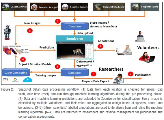
The first stage of classification occurs on the Zooniverse in a binary workflow, in which volunteers evaluate whether animals can be seen in the images. If two people agree with the algorithm that an image is empty, it is removed from the data set. If one person disagrees with the computer, the image remains in circulation to accumulate three more human votes, at which point majority consensus is accepted. Images marked as containing wildlife are moved to the second stage of classification, in which the species, count, and behaviours are annotated. At this stage, dynamic rules within the Zooniverse infrastructure are used to retire captures based on the species, agreement of the volunteers with the computer and one another, and the algorithm's confidence in its own prediction.
As a result of quickly removing blank images and those of humans and common species, citizen scientists are presented with more images of rare and cryptic species, improving the volunteer experience14 and providing valuable data to refine the machine learning algorithm's capabilities. This approach has improved efficiency by 43% thus far on the Serengeti project.10 Citizen science and machine learning stages are applied iteratively to constantly improve performance and efficiency. The labelled images from all projects retrain the existing model to improve the machine's predictive capability in a variety of habitats, and the refined model is run on new data sets as they are collected from the field (Figure 2).
Snapshot also provides useful data for computer scientists who wish to build artificial intelligence algorithms to identify wildlife species automatically without human assistance. Data from six South African sites and the Serengeti are publicly available for download on the Microsoft-hosted site Labelled Image Library of Alexandria - Biology & Conservation (LILA-BC) at www.lila.science.com. More data are added to the labelled image repository as datasets are finalised. In all cases, images of humans and rhinoceros are withheld from the repository for privacy and poaching concerns, respectively. Metadata on habitat and environmental characteristics are available to researchers outside of the network upon request. This ensures that local researchers and reserve management are aware of how the data are being used and can contribute and collaborate.
Outputs and general results
Snapshot is documenting the presence, distribution, diversity, and ecology of at least 85 medium- to large-sized African mammals. The variety of Snapshot locations provides numerous opportunities to answer questions in wildlife ecology and conservation, test ecological hypotheses and analytical methods, and measure the impacts of anthropogenic disturbances across multiple spatiotemporal scales. For example, the data produced by the camera traps running continuously in the Serengeti provided the basis for papers on spatiotemporal partitioning15-17, behavioural interactions18-20, and advancing modelling techniques used with the camera trap data11,19,21.
Scientists visit sites regularly to maintain and manage the camera trap grids and also to improve community participation. For example, in Ruaha National Park (Tanzania), researchers trained community members to deploy and maintain the grid22, thus creating jobs and infrastructure. In South Africa, we are building strong relationships with local communities, such as the Khomani San in the Kalahari and managers of private reserves, who will use the camera trap information to improve their wildlife management practices.
Snapshot Safari - South Africa
Like other African countries, South Africa lacks adequate conservation data for many species, and about 17% of mammal species are threatened with extinction.8 However, South Africa has a long history of conservation intervention and is, therefore, a testing ground for different hypotheses. In South Africa, we have surveyed 31 locations (Figure 1), of which 21 are permanent grids for long-term monitoring purposes. These represent a total of 1 408 cameras deployed for grids on permanent locations and 873 installed in the roaming locations. More than 43 000 volunteers have annotated approximately 18 months of data for 19 of these sites and classified more than 2 million photos to date.
Our grids and collaborative research allow us to combine different questions and leverage the full potential of camera traps. For example, in the Kruger National Park we have set up the cameras along with studies of the phenology of vegetation cover (e.g. tree and herbaceous composition, cover and structure), which has created an opportunity to monitor the vegetation dynamic while accounting for mammal presence. Further, by-catch data (not targeted species), such as birds or human activity, will represent an interesting opportunity to investigate other species in the future. The potential role of this by-catch data of camera trap studies to conservation efforts or ecological studies has recently been highlighted.23
Our grids have documented sightings of some threatened and elusive species outside known distribution ranges as well as unusual behavioural interactions. In 2019, for example, we detected a leopard (Panthers parous) near Karoo National Park. Similarly, we photographed a brown hyaena (Parahyaena brunnea) in Camdeboo National Park. None of these records was expected as no official or anecdotal records have existed since colonial times and therefore these sightings represent significant recent geographic range shifts for these species. In June 2019 in the Karoo National Park, one of the Snapshot cameras took 21 pictures of three to five meerkats (Suricata suricatta) and a yellow mongoose (Cynictis penicillata) foraging together. An analysis of the photographic sequence suggested they were sharing vigilance and staying near each other. These observations constitute new evidence to support the only previous observation of this cooperative behaviour in the Andries Vosloo Kudu Nature Reserve in the Eastern Cape Province.24
We aim to be as collaborative as possible and share data to facilitate other conservation and research projects. For example, we have shared ~5500 records with the MammalMAP initiative, which provides a platform for citizen scientists and researchers to contribute biodiversity information for South Africa (http://vmus.adu.org.za/). We expect to make data available on other platforms such as the Foundational Biodiversity Information Programme in South Africa (http://fbip.co.za/) and the Global Biodiversity Information Facility to help evaluate progress toward governmental agreements such as the UN Sustainable Development Goals. Evaluating trends at the broad geographic scale of the Snapshot network can inform IUCN Red List entries on species for which we currently lack accurate estimates of extant population sizes.
Systematic long-term monitoring is crucial to understand the trends in populations and species through time and to facilitate informed management decisions. However, data collection via camera traps has increased at a much faster rate than have our technical capabilities to analyse such large data sets.25 Another limitation is the access to research groups and computational centres with sufficient processing infrastructure to train and run machine learning algorithms. In our project, for example, the information is analysed by the Lion Center at the University of Minnesota. All data are sent to that lab group for the management of the online classification process and data curation. This can create a bottleneck and slow the data pipeline. One potential solution is to set up multiple hubs within a network, which we plan to enact by copying existing infrastructure onto South Africa's supercomputer at the Centre for High Performance Computing. This continues the trend of distributed management and provides additional opportunities for training and professional development.
Future directions and conclusions
The Snapshot collaborators in South Africa meet annually to review current projects, prioritise future research, and plan funding activities. At the 2019 meeting, we defined five research themes:
• Theme 1: The role of anthropogenic landscapes in shaping biodiversity, distributions, populations, and communities.
• Theme 2: Investigating ecological interactions and food webs through space and time.
• Theme 3: Understanding and predicting the consequences of climate change for mammal behaviour, distribution, adaptation, and community composition.
• Theme 4: Assessment of conservation priorities and protected area effectiveness.
• Theme 5: Merging camera trap data with other data to address more specific questions and improve monitoring.
Snapshot's integration of scientists, citizens, and technology can provide meaningful assessments of the status of southern African mammals at fine or broad scales. Our collaboration also holds the potential to contribute to advancing statistical and technological capacity in South Africa as well as to support environmental education for the general public. With the current advances in data processing, we are hopeful that Snapshot will provide timely recommendations and relevant ecological information to support southern Africa's national and international commitments to conserving one of the most biodiversity rich regions in the world. However, only political will and multi-sectoral commitments will make it possible to leverage the full potential of technology to produce practical effects.
Reserves and researchers who wish to join the Snapshot network should contact Sarah Huebner at huebn090@umn.edu or Jan Venter at Jan.Venter@mandela.ac.za
Acknowledgements
We thank all the Zooniverse volunteers who contribute classifications to Snapshot Safari, and the moderators who donate their time and expertise to our projects. We also thank sponsors of our work, including the South African National Biodiversity Institute (SANBI), Foundational Biodiversity Information Programme (FBIP), South African National Research Foundation (NRF), Fynbos Trust, Nelson Mandela University, Fairfields, Detroit Zoological Society, Zoo Miami, Cincinnati Zoo Angel Fund, Seneca Park Zoo, and The Living Desert. We thank the Minnesota Supercomputing Institute for providing resources for data storage and processing, among others. Finally, we thank all the people and institutions participating in Snapshot South Africa, including the reserve managers and owners for providing access and supporting this programme, National Parks Institutions of every country, students and volunteer groups helping to maintain the grids, and the governmental institutions overseeing these parks and reserves.
References
1. Díaz S, Settele J, Brondízio ES, Ngo HT, Agard J, Arneth A, et al. Pervasive human-driven decline of life on Earth points to the need for transformative change. Science. 2019;366(6471), eaax3100. https://doi.org/10.1126/science.aax3100 [ Links ]
2. Ceballos G, Ehrlich PR, Dirzo R. Biological annihilation via the ongoing sixth mass extinction signaled by vertebrate population losses and declines. Proc Natl Acad Sci USA. 2017;114(30):E6089-E6096. https://doi.org/10.1073/pnas.1704949114 [ Links ]
3. Ahumada JA, Hurtado J, Lizcano D. Monitoring the status and trends of tropical forest terrestrial vertebrate communities from camera trap data: A tool for conservation. PLoS ONE. 2013;8(9), e73707. https://doi.org/10.1371/journal.pone.0073707 [ Links ]
4. Donlan CJ, Tershy BR, Campbell K, Cruz F. Research for requiems: The need for more collaborative action in invasive species management and conservation. Conserv Biol. 2003;17(6):1850-1851. https://doi.org/10.1111/j.1523-1739.2003.00012.x [ Links ]
5. Barnard P Altwegg R, Ebrahim I, Underhill LG. Early warning systems for biodiversity in southern Africa - How much can citizen science mitigate imperfect data? Biol Conserv. 2017;208:183-188. https://doi.org/10.1016/j.biocon.2016.09.011 [ Links ]
6. Jensen D, Campbell J. Discussion paper: The case for a digital ecosystem for the environment: Bringing together data, algorithms and insights for sustainable development. Science Policy Business Forum. Nairobi: UN Environment; 2019. [ Links ]
7. Tilman D, Clark M, Williams DR, Kimmel K, Polasky S, Packer C. Future threats to biodiversity and pathways to their prevention. Nature. 2017;546(7656):73-81. https://doi.org/10.1038/nature22900 [ Links ]
8. Child M, Roxburgh L, Do Linh San E, Raimondo D, Davies-Moster H. The 2016 red list of mammals of South Africa, Swaziland and Lesotho. South Africa: South African National Biodiversity Institute, Endangered Wildlife Trust; 2016. [ Links ]
9. Swanson A, Kosmala M, Lintott C, Simpson R, Smith A, Packer C. Snapshot Serengeti, high-frequency annotated camera trap images of 40 mammalian species in an African savanna. Sci Data. 2015;2(1):150026. https://doi.org/10.1038/sdata.2015.26 [ Links ]
10. Willi M, Pitman RT, Cardoso AW, Locke C, Swanson A, Boyer A, et al. Identifying animal species in camera trap images using deep learning and citizen science. Methods Ecol Evol. 2019;10(1):80-91. https://doi.org/10.1111/2041-210X.13099 [ Links ]
11. Swanson A, Kosmala M, Lintott C, Packer C. A generalized approach for producing, quantifying, and validating citizen science data from wildlife images. Conserv Biol. 2016;30(3):520-531. https://doi.org/https://doi.org/10.1111/cobi.12695 [ Links ]
12. Norouzzadeh MS, Nguyen A, Kosmala M, Swanson A, Palmer MS, Packer C, et al. Automatically identifying, counting, and describing wild animals in camera-trap images with deep learning. Proc Natl Acad Sci USA. 2018;115(25):E5716-E5725. https://doi.org/10.1073/pnas.1719367115 [ Links ]
13. Gomez A, Salazar A, Vargas F. Towards automatic wild animal monitoring: Identification of animal species in camera-trap images using very deep convolutional neural networks. Ecol Inform. 2016;41:24-32. https://doi.org/10.1016/j.ecoinf.2017.07.004 [ Links ]
14. Spiers H, Swanson A, Fortson L, Simmons BD, Trouille L, Blickhan S, et al. Everyone counts? Design considerations in online citizen science. J Sci Commun. 2019;18(1):A04. https://doi.org/10.22323/2.18010204 [ Links ]
15. Anderson TM, White S, Davis B, Erhardt R, Palmer M, Swanson A, et al. The spatial distribution of African savannah herbivores: Species associations and habitat occupancy in a landscape context. Philos Trans R Soc B Biol Sci. 2016;371(1703), 20150314. https://doi.org/10.1098/rstb.2015.0314 [ Links ]
16. Hepler SA, Erhardt R, Anderson TM. Identifying drivers of spatial variation in occupancy with limited replication camera trap data. Ecology. 2018;99(10):2152-2158. https://doi.org/10.1002/ecy.2396 [ Links ]
17. Palmer MS, Fieberg J, Swanson A, Kosmala M, Packer C. A 'dynamic' landscape of fear: Prey responses to spatiotemporal variations in predation risk across the lunar cycle. Ecol Lett. 2017;20(11):1364-1373. https://doi.org/10.1111/ele.12832 [ Links ]
18. Allen ML, Peterson B, Krofel M. No respect for apex carnivores: Distribution and activity patterns of honey badgers in the Serengeti. Mamm Biol. 2018;89:90-94. https://doi.org/10.1016/j.mambio.2018.01.001 [ Links ]
19. Palmer MS, Packer C. Giraffe bed and breakfast: Camera traps reveal Tanzanian yellow-billed oxpeckers roosting on their large mammalian hosts. Afr J Ecol. 2018;56(4):882-884. https://doi.org/10.1111/aje.12505 [ Links ]
20. Swanson A, Arnold T, Kosmala M, Forester J, Packer C. In the absence of a "landscape of fear": How lions, hyenas, and cheetahs coexist. Ecol Evol. 2016;6(23):8534-8545. https://doi.org/10.1002/ece3.2569 [ Links ]
21. Cusack JJ, Swanson A, Coulson T, Packer C, Carbone C, Dickman AJ, et al. Applying a random encounter model to estimate lion density from camera traps in Serengeti National Park, Tanzania. J Wildl Manage. 2015;79(6):1014-1021. https://doi.org/10.1002/jwmg.902 [ Links ]
22. Dickman AJ, Hazzah L, Carbone C, Durant SM. Carnivores, culture and "contagious conflict": Multiple factors influence perceived problems with carnivores in Tanzania's Ruaha landscape. Biol Conserv. 2014;178:19-27. https://doi.org/10.1016/j.biocon.2014.07.011 [ Links ]
23. Hofmeester TR, Young S, Juthberg S, Singh NJ, Widemo F, Andren H, et al. Using by-catch data from wildlife surveys to quantify climatic parameters and the timing of phenology for plants and animals using camera traps. Remote Sens Ecol Conserv. 2019;6(2):129-140. https://doi.org/10.1002/rse2.136 [ Links ]
24. Do Linh S, Somers MJ. Mongooses on the move : An apparent case of interspecific cooperative vigilance between carnivores. South Afr J Wildl Res. 2006;36(2):201-203. [ Links ]
25. Ahumada JA, Fegraus E, Birch T, Flores N, Kays R, O'Brien TG, et al. Wildlife insights: A platform to maximize the potential of camera trap and other passive sensor wildlife data for the planet. Environ Conserv. 2019;47(1):1-6. https://doi.org/10.1017/s0376892919000298 [ Links ]
 Correspondence:
Sarah Huebner
Email: huebn090@umn.edu
Published: 29 January 2021

