


Servicios Personalizados
Articulo
 Inglés (pdf)
 Articulo en XML
 Referencias del artículo
Indicadores

Links relacionados
-
 Citado por Google
 -
 Similares en Google
Compartir

 Permalink
South African Journal of Science
versión On-line ISSN 1996-7489
versión impresa ISSN 0038-2353
S. Afr. j. sci. vol.116 no.9-10 Pretoria sep./oct. 2020
http://dx.doi.org/10.17159/sajs.2020/8156
RESEARCH ARTICLE
Newly identified hominin trackways from the Cape south coast of South Africa
Charles W. HelmI; Martin G. LockleyII; Hayley C. CawthraI, III; Jan C. De VynckI; Mark G. DixonI; Carina J.Z. HelmI; Guy H.H. ThesenI
IAfrican Centre for Coastal Palaeoscience, Nelson Mandela University, Port Elizabeth, South Africa
IIDinosaur Trackers Research Group, University of Colorado, Denver, Colorado, USA
IIIGeophysics and Remote Sensing Unit, Council for Geoscience, Cape Town, South Africa
ABSTRACT
Three new Pleistocene hominin tracksites have been identified on the Cape south coast of South Africa, one in the Garden Route National Park and two in the Goukamma Nature Reserve, probably dating to Marine Isotope Stage 5. As a result, southern Africa now boasts six hominin tracksites, which are collectively the oldest sites in the world that are attributed to Homo sapiens. The tracks were registered on dune surfaces, now preserved in aeolianites. Tracks of varying size were present at two sites, indicating the presence of more than one trackmaker, and raising the possibility of family groups. A total of 18 and 32 tracks were recorded at these two sites, respectively. Ammoglyphs were present at one site. Although track quality was not optimal, and large aeolianite surface exposures are rare in the region, these sites prove the capacity of coastal aeolianites to yield such discoveries, and they contribute to what remains a sparse global hominin track record. It is evident that hominin tracks are more common in southern Africa than was previously supposed.
SIGNIFICANCE:
• Three new Pleistocene hominin trackways have been identified on the Cape south coast, bringing the number of known fossil hominin tracksites in southern Africa to six.
• The tracks were all registered on dune surfaces, now preserved as aeolianites.
• These are the six oldest tracksites in the world that are attributed to Homo sapiens.
• Hominin tracks are more common in southern Africa than was previously supposed.
Keywords: Homo sapiens, fossil tracks, aeolianites, southern Africa, Pleistocene
Introduction
The Cape south coast of South Africa has been shown to be of pivotal importance in the origin of cognitively modern humans in the Middle Stone Age, with sites such as Blombos Cave1, Pinnacle Point2, and Klasies River3 achieving international renown. Examples of the early emergence of modern human behaviour include adornment through the use of ochre1,4, creation of jewellery5, development of microlithic technology6, heat treatment of stone tools7, manufacture of bone tools8, and the creation of abstract symbols, both as petroglyphs9,10 and pictographs11. Marean2, documenting the first known systematic exploitation of seafood by humans, postulated that the Cape south coast formed a refugium that facilitated human survival during the harsh climate of Marine Isotope Stage (MIS) 6.
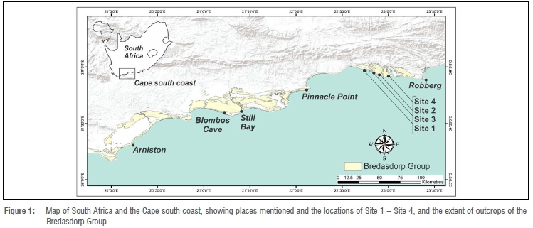
Fortuitously, the surfaces of unconsolidated dunes on which those early humans trod and travelled during the Pleistocene have the capacity to be preserved on the current coastline as aeolianites (cemented dune deposits), and to provide a record of events that transpired on them. Ichnology, the study of tracks and traces, therefore has the potential to complement this corpus of research. Indeed, our Cape south coast ichnology project has documented more than 250 vertebrate tracksites in our study area (Figure 1), which extends for 350 km from the town of Arniston in the west to the Robberg peninsula in the east.12 For example, the presence of giraffe13, crocodiles14, and breeding sea turtles15 was not suspected from the skeletal record, and has only been established through the presence of their tracks.
Ichnological evidence of the human presence on this coast was confirmed through description of a hominin tracksite at Brenton-on-Sea.16 This discovery added to the sparse number of reported Pleistocene southern African hominin tracksites, namely Langebaan on the west coast and Nahoon on the southeast coast.17 While the Langebaan tracks have not been universally accepted as having been made by humans18, for the purposes of this article we follow the consensus that they are of probable hominin origin. As a result, southern Africa currently lays claim to the only hominin tracksites in the world older than 46 ka that have been attributed to Homo sapiens.16,18-21
In our continuing exploration of the Cape south coast we have identified further tracksites, which we are comfortable in ascribing to hominin trackmakers. The purpose of this article is to describe these newly identified ichnosites, to consider criteria for the identification of hominin tracks in this region in softer substrates, and to consider the implications of these discoveries. We confine ourselves here to tracks of unshod humans; the possibility of humans sometimes using footwear in this region during the Middle Stone Age will be discussed elsewhere.
Background
The global hominin track record
Comprehensive reviews of global hominin tracksites and hominin ichnotaxonomy are found in Lockley et al.19,20,22, Kim et al.23, and Bennett and Morse18. Lockley et al.19 listed 63 sites, and Bennett and Morse18 listed 44 sites. Further sites have been reported subsequent to the publication of these reviews.16,24,25 Compared with the three southern African sites thus far reported, there are only six generally accepted older hominin tracksites in the world18-20, and none of these are attributed to Homo sapiens. Thus southern Africa has to date proven to be the region in which to search for Middle Stone Age tracks of our species.
While the southern African sites (including the new sites we describe here) all occur on aeolianite surfaces, this is not a common phenomenon from a global perspective. Solidified volcanic ash deposits or undisturbed cave floor deposits are not only commoner, but also have the capacity to preserve track morphology in greater detail than do the southern African aeolianites. Belvedere and Farlow26 proposed a four-point scale (0-1-2-3) for quantifying the preservation quality of vertebrate tracks. Tracks registered and preserved in dune facies usually will not score more than 2 on this scale. Another feature of the global record is that the majority of hominin tracksites are preserved in epirelief (i.e. as natural impressions on the original surface), while in southern Africa these sites are mostly preserved in hyporelief (i.e. as natural casts on the infill surface).
The southern African hominin track record
The three previously reported southern African sites (Figure 1), in order of their initial description, are:
1. The Nahoon site, situated in South Africa's Eastern Cape province, and comprising three hominin tracks in hyporelief, was identified in 1964.17,27 The tracks occur in the Nahoon Formation of the Algoa Group.28 Soon after its discovery, the in-situ aeolianite slab containing the tracks collapsed. However, the tracks were recovered, and are housed in the East London Museum (South Africa). They have been dated through optical stimulation luminescence (OSL) to ~124 ka.29
2. The Langebaan tracksite, situated on the Cape west coast in South Africa's Western Cape Province, and comprising three probable hominin tracks in epirelief, was identified in 1995.17,30 The tracks occur in the Langebaan Formation of the Sandveld Group.31 The tracks were recovered and are housed in the Iziko South Africa Museum, Cape Town. They have been dated through OSL to -117 ka.17
3. The Brenton-on-Sea site, comprising as many as 40 tracks in hyporelief and cross-section on the ceiling and walls of a small coastal cave, was identified in 2016 and reported on in 2018.16 The tracks occur in aeolianites in the Waenhuiskrans Formation of the Bredasdorp Group.32 The tracks were made by a party of humans moving rapidly down a dune slope.16 Short trackways were evident. An age estimate of 90 ka was obtained using carbonate diagenesis and stratigraphic correlation to nearby dated sites.16 The tracks were not manually recoverable, and a digital record was obtained through photogrammetry. OSL results are awaited.
Tuttle33 developed criteria for hominin track identification:
• The hallux (digit I) is aligned with the four lateral toes (digits II-V), which are short and straight.
• The tip of the hallux is bulbous, not tapered.
• The tips of the hallux and adjacent second and third toes do not project markedly beyond one another.
• A prominent medial longitudinal arch is evident.
Morse et al.34, in reporting on Holocene tracks (including human tracks) from Namibia, examined the influence of different substrates on footprint morphology. Anticipating the possible identification of further southern African sites, and appreciating that Tuttle's criteria33 applied to near-ideal substrates and track preservation, Helm et al.21 reviewed described sites from the region and considered putative sites, developing criteria on which to base the investigation of future discoveries.
In a further development, Helm et al.35 reported on evidence that hominins left more than just tracks on these surfaces, and that patterns indicating a hominin 'signature' could be identified on aeolianite surfaces. These patterns could represent the creation of palaeo-art or abstract motifs, messaging or foraging. The term 'ammoglyph' was coined to describe such findings. One site included possible human knee impressions35, adding to a very sparse global record of such features36,37.
Next described was the first example on the Cape south coast of Middle Stone Age tools embedded in a Pleistocene track-bearing palaeo-surface, containing tracks of crocodiles, birds and mammals.14 The tracksites we describe here therefore need to be considered in the broader context of features related to human activity on Pleistocene aeolianite surfaces on the Cape south coast, including ammoglyphs and Middle Stone Age tools, and the possibility of shod human tracks.
Geological context
Pleistocene sediments on the Cape south coast form part of the Bredasdorp Group. Within this Group, Pleistocene aeolianites, cemented palaeodunes and interdune areas of calcarenite38, form part of the Waenhuiskrans Formation32. We are confident that the tracksites described here occur in situ in aeolianites, and not in marine deposits of the Klein Brak Formation.39 These Pleistocene deposits have been dated to between 400 ka and 36 ka through OSL40-45, with dated results indicating several MIS 5 deposits.
Aeolianites extend intermittently along much of South Africa's present-day coastline, and are well exposed in embayments on or near the shoreline.46 They are composed of medium- to fine-grained sand with a high carbonate content derived from marine shell fragments. They lithify as a result of the downward percolation of rainwater in the meteoric diagenetic zone; the carbonate shell component is mobilised and re-deposited as interstitial cement within the sandstone matrix.47
The sites described here occur within or close to the Wilderness Embayment.44,48,49 Here the Pleistocene stratigraphy consists mostly of MIS 6 and MIS 5 deposits, draped by an unconsolidated unit of modern dunes.44 OSL dates from this region range from 148 ka ± 10 ka to 79 ka ± 9 ka.44
The distance of the tracks from the coastline at the time they were registered is related to Pleistocene sea-level oscillations and the periodic exposure of the Palaeo-Agulhas Plain, as a result of global temperature changes. For example, around 91 ka, during MIS 5c, sea levels were as much as 45 m lower than at present, and the coastline in this area was up to 60 km seaward of the present-day coast.5052 In contrast, around 126 ka, at the time of the peak MIS 5e high-stand53, sea levels were 6-8 m higher than present41,54. Because Quaternary tectonic activity is considered minimal along the Cape south coast55, in-situ strata lie at or close to their original angles of deposition, often at the angle of repose of wind-blown sand.
Less than a quarter of the Cape south coast comprises Pleistocene exposures. The remainder consists of Palaeozoic quartzite, sandstone and shale exposures of the Cape Supergroup, Precambrian granite exposures of the Cape Granite Suite, and expanses of beach and unconsolidated Holocene beach and dune sediments.56
Tracksites, once exposed, are subjected to erosive forces of water and wind, including wave action. Consequently, there is often a relatively short window in which to document such sites before their quality deteriorates or they are destroyed entirely.
Methods
Global Positioning System readings were taken using a handheld device. Locality data were reposited with the African Centre for Coastal Palaeoscience at Nelson Mandela University, South Africa, to be made available to bona fide researchers upon request. Tracksites were interpreted in the field through correlation to dated deposits, and samples were taken for OSL dating.
Where appropriate, track length, track width, track depth, pace length, stride length, and thickness of foresets were measured.57 Results were recorded in centimetres. Dip and strike measurements were recorded. Where feasible, a 50 cm x 50 cm grid system was employed to create a sketch map of the track-bearing surfaces, along with a numbering system for the tracks. Trackway maps were developed using Adobe Illustrator (version 23.0.3) and Microsoft PowerPoint (version 1908).
Photographs were taken, including images for photogrammetry.58 Photogrammetry 3D models were generated with Agisoft MetaShape Professional (v. 1.0.4) using an Olympus TG-5 camera (focal length 4.5 mm; resolution 4000 x 3000; pixel size 1.56 x 1.56 um). The final images were rendered using CloudCompare (v2.6.3.beta); details are provided in the relevant figure captions.
Results
Site 1: Garden Route National Park
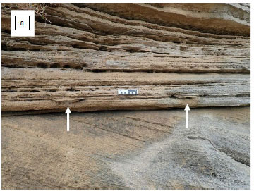
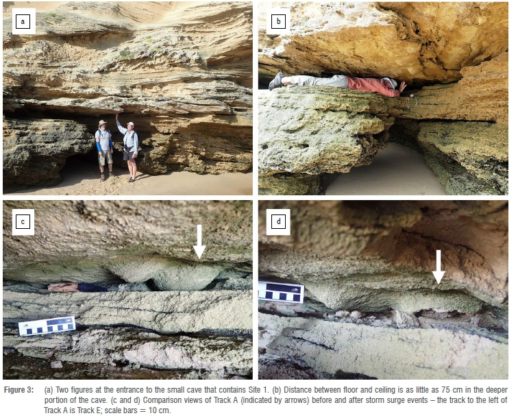
Site 1 lies within the coastal section of the Garden Route National Park, between the towns of Wilderness and Sedgefield. The tracks occur on the ceiling of a cave at the foot of aeolianite cliffs. We generated a trackway map of this surface (Figure 2). The strike of this surface is 100°, with a gentle dip of 4°. This cave is situated near the high water mark (Figure 3a). Its interior and ceiling are buffeted by waves during high tides and storm surges.

As many as 18 tracks occur as natural casts (i.e. in hyporelief) on this ceiling, although some of these have indistinct margins or are not accessible for analysis. For this reason, we have only assigned identifier labels to seven of the tracks (Track A - Track G). The tracks have a compound aspect, i.e. the stratigraphically lower expressions are rounded oval 'casts' (convex hyporeliefs) resembling a boat hull, and interpreted as transmitted tracks impacting layers a few laminae below where the trackmakers made direct 'true track' contact with the substrate.59 Where these transmitted track surfaces have been eroded into, it is possible to observe the cross-sections of the nested, convex-down laminae, just above the more widely exposed surface revealing the transmitted track casts in hyporelief. Thus the generic term 'track' can refer to the stacked sequence in which the 'true track' is nested in, and expressed by, its underlying transmitted track features.
The cave has a sandy floor; the vertical distance from floor to ceiling is 190 cm at the dripline at the seaward end. From here it extends into the cliffs in a northerly direction, and the vertical distance between floor and ceiling decreases to a minimum of 75 cm (Figure 3b). From this point it continues as a tunnel in a more northwesterly direction to a northwestern entrance, with a vertical distance between floor and ceiling of 150 cm at this entrance. The total length of this cave/tunnel is 8 m. All the tracks occur in the seaward (southern) portion.
Two further track-bearing surfaces are preserved in epirelief below the main layer. One surface lies 43 cm below the main layer, and contains ~24 small, unidentifiable tracks on a rippled surface. The second lies a further 8 cm lower in the section, and contains 16 small- and medium-sized bovid tracks. Still lower in the section are heavily bioturbated layers. The tracks of the main track-bearing surface in the deeper portion of the cave can only be accessed with some difficulty via a 30 cm gap between bedding planes.
The site was initially identified in 2013, but only analysed in detail in 2019. While photographs confirm that there was minimal degradation of the tracks between 2013 and 2019, a significant interval change occurred over a 6-week period in 2019 following storm surges, resulting in the partial loss of one of the better-preserved tracks (Track A). Further subsequent degradation of the surface has occurred (Figure 3c, 3d).
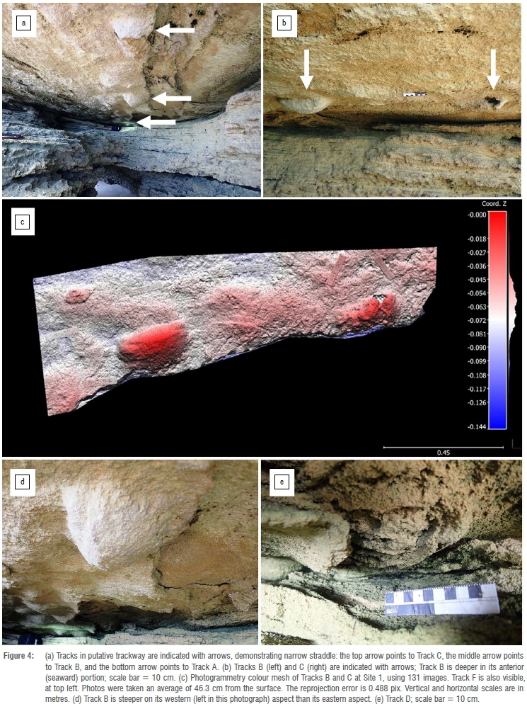
With one exception (described below) the tracks have a similar south-southwest orientation of ~222°. The main trackway appears very straight, with a narrow straddle (Figure 4a). While some of these tracks have indistinct margins, the three best-preserved tracks exhibit the following dimensions:
• Track A: 24 cm long, 11 cm wide, maximum depth 6.5 cm
• Track B: 26 cm long, 12 cm wide, maximum depth of 7.5 cm
• Track C: 24 cm long, 11 cm wide, depth not measurable
When viewed in sagittal section, the deepest points of these tracks are in their anterior (seaward) portions (Figure 4b). Photogrammetry was applied to the portion of the surface containing Track B and Track C (Figure 4c).
Although it is partly eroded, Track C appears to exhibit evidence of a medial longitudinal arch on its western aspect, and relative widening of its seaward (southern) portion along with vague evidence of a hallux orientated in the longitudinal access of the track. Consequently, it appears to be a natural cast of a left foot impression. We infer that the trackmaker was heading in an approximately southerly direction down a gently inclined surface.
This inference is borne out by the appearance of Track B in coronal section, which, although it shows little other morphological detail, is steeper on its western aspect than its eastern aspect, suggesting that it is a natural cast of a right foot impression (Figure 4d). The pace length between Track B and Track C is 82 cm.
A similar coronal section profile is evident in Track A, suggesting that it too is a natural cast of a right foot impression. If this is the case, and Tracks A and B form part of the same trackway, then the stride length between them is 165 cm.
If this analysis is accurate, then unfortunately the area where a left track would have occurred between tracks A and B has been eroded away. However, the remnants of a number of other tracks are evident on the ceiling in this eroded area, and layers in the side wall of the cave in this area show significant deformation, indicating that a substantial number of tracks must once have been present (Figure 4e).
An alternative interpretation is that one of these large eroded tracks, e.g. Track D, formed part of the trackway that includes Track B and Track C (Track D appears to be of approximately similar size to Tracks A, B and C, but is too eroded to permit detailed measurement). In this case, stride length would be -145 cm.
More tracks are evident in hyporelief in the deeper, less accessible section of the cave, in the same axis as the putative trackway. However, these tracks do not appear to be well defined, and do not exhibit detailed morphology.
Of the tracks that are amenable to measurement, some appear to be significantly smaller than others, although Tracks A, B and C are similar in size, with characteristic hominin dimensions. For example, just west of Track A, and with similar orientation, is a probable track with a length of 13 cm (Track E). Close to the eroded area described above, one very eroded track (not shown in Figure 2) measures 15 cm in length and 8 cm in width, with a distinct vestigial outline and evidence of a medial longitudinal arch. The smallest natural cast feature, 9.5 cm in length and 5.5 cm in width, lies west of Track B. Because it contained no further distinguishing features, and although we assigned it a label (Track F), we could not be certain that it represented a hominin track.
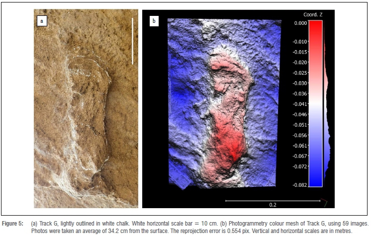
In a seaward direction from Track C, and -90 cm from it, another track is evident in hyporelief (Track G). Its orientation is almost perpendicular to that of the other tracks, with a bearing of 131o. It measures 24 cm in length and 10 cm in width (again consistent with the approximate dimensions of Tracks A, B and C), with a maximum depth of 5 cm and a minimum depth of 2.5 cm (Figure 5a). A heel-drag impression of 6 cm is apparent. As in the case of Track C, it appears broader in its anterior (distal) portion. Anterior to this, a vague hallux outline is evident in the longitudinal axis of the track, and a small ridge is evident posterior to the digit line. In this sense the track is better preserved than those with transmitted track features. For example, this track cast has rather steep walls, and so differs from the more rounded shapes of the transmitted tracks which therefore by definition show extra-morphological characteristics, and which we infer may have existed below Track G as transmitted features before they were eroded away. Additional tracks are evident, mostly in cross-section, at the junction of the ceiling with the eastern side wall of the cave, but these are not amenable to further interpretation. Photogrammetry was applied to Track G (Figure 5b).
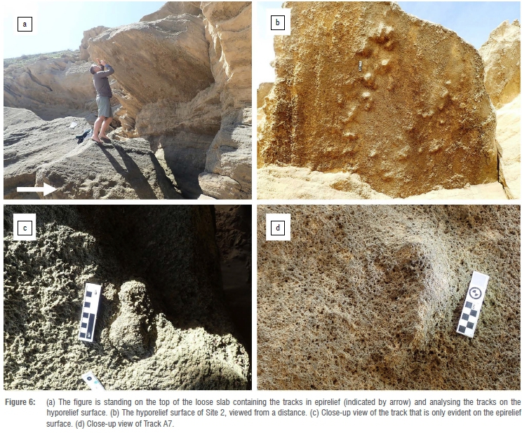
Site 2: Goukamma Nature Reserve
Site 2 lies on the coastline of the Goukamma Nature Reserve, between the towns of Sedgefield and Buffels Bay. It was initially identified in 2012, but not analysed in detail until 2019. No significant deterioration appears to have taken place during this time interval. The track-bearing surface is evident in situ as hyporelief casts in cliffs that rise above the upper end of a beach, and as corresponding epirelief impressions on the upper surface of a fallen block at the foot of these cliffs (Figure 6a, 6b). The in-situ hyporelief surface has a strike measurement of 71o, with a dip measurement of 35o. The surface represents the infill layer of a Pleistocene dune, at the angle of repose of windborne sand. It measures 320 cm in width (east-west) and 260 cm from north to south. Its lowest point (at the northern end) is 270 cm above the basal sand level. Its highest point (at the southern end) is 418 cm above this sand level.
In contrast to Site 1, through the existence of both natural impressions (on the fallen block) and corresponding natural casts (on the in-situ overhang), we are encouraged to infer that the separation layer was probably the original track-bearing surface, and thus a temporarily exposed palaeosurface. Moreover, the separation resulted from the falling of the lower block, and perhaps a weakness at the palaeosurface, and not directly as the result of layers below the casts being actively eroded and dissolved away by forceful and direct marine erosion. This distinction is important, as it suggests the quality of preservation, although affected by some post-separation exposure, likely reflects the original quality of preservation on the track-bearing surface, and characteristics that the palaeosurface developed when exposed. These characteristics may have included subtle weathering of the tracks before burial.
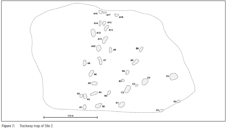
The surface can be informally divided into four track-bearing areas. We created a trackway map of the hyporelief surface, which indicates these areas (Figure 7). To the west are 18 tracks which we interpret as having been registered in a north-to-south (upslope) direction. We label this Section A, and number these tracks from A1 to A18. It is evident that there are too many tracks in this section to have been formed by one trackmaker. Beginning near the northern (lower) area of these tracks, two approximately parallel trackways, containing six and five tracks, extend diagonally upslope in a southeasterly direction. The more southerly (more upslope) trackway contains six tracks. We label this Section B, and number these tracks from B1 to B6. The more northerly (more downslope) trackway contains five tracks. We label this Section C, and number these tracks from C1 to C5. Two further tracks, which we label D1 and D2, are evident further to the east in cross-section, where the track-bearing surface meets the cliff.
At a sectional distance of 80 cm below the main track-bearing surface there is another track-bearing layer, with unidentifiable tracks evident in cross-section and in hyporelief. A further probable track-bearing layer is evident in cross-section 70 cm below this layer.
The epirelief surface on the fallen block measures 270 cm from east to west and 280 cm from north to south. It is sometimes covered by sand. Not as many tracks are registered in epirelief, and their state of preservation is generally of inferior quality to those seen in hyporelief. However, this surface enables easier appreciation of numerous downslope displacement rims, which correspond to depressions on the hyporelief surface. It contains one track that is not apparent on the hyporelief surface, as the infill of this track must have broken off from the hyporelief surface when the block broke off. It is sharply outlined, and fills the depression on the epirelief surface (Figure 6c). Its anterior portion is wider than the posterior portion. In total there are therefore 32 tracks.
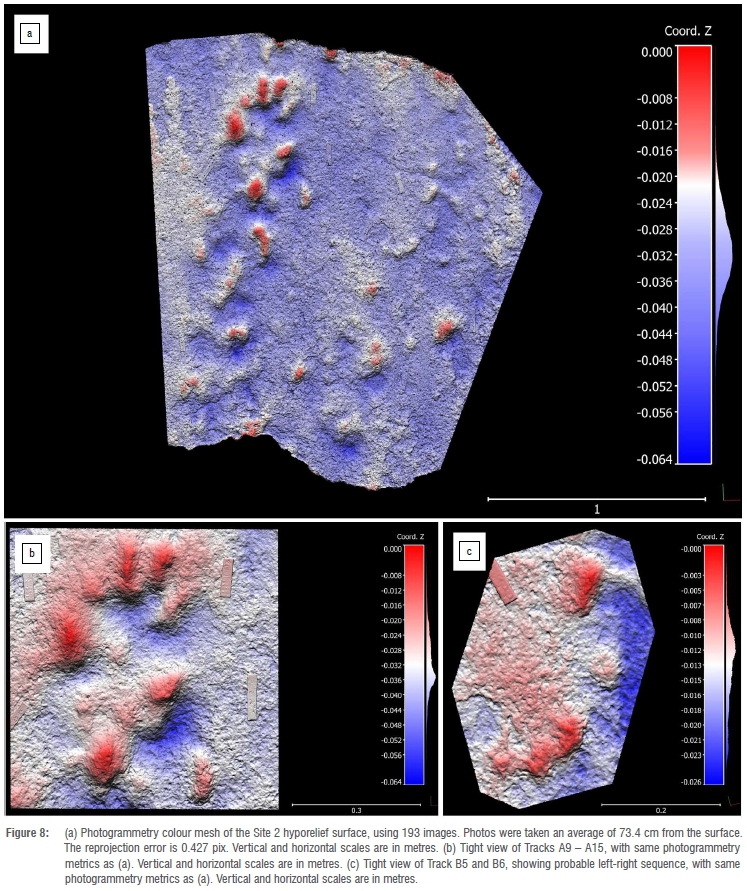
While some tracks in Section A are substantially longer than they are wide, and there is a size difference between some of the better-preserved tracks (suggesting the presence of more than one trackmaker), the outlines of others are poorly preserved or are truncated by the edge of the surface. Therefore, not all of these tracks were amenable to measurement. In some cases, where a probable medial longitudinal arch was present, left or right tracks could be identified (Figure 6d). Better preserved track morphology (including overall track dimensions and the presence of a medial longitudinal arch in some tracks) was noted in Trackway B. Measured dimensions, along with comments, are provided in Supplementary table 1. We applied photogrammetry to the hyporelief surface (Figure 8a) along with detailed views (Figure 8b, 8c), and the epirelief surface (Supplementary figure 1).
Sections A and B each provided evidence of a trackway. In the case of Section A, where many tracks were noted, with a similar longitudinal axis, but of varying size, a number of plausible trackways were identified, but none were unequivocal. Intertrack distances (plausible putative pace lengths) are presented in Supplementary table 2.
Site 3: Goukamma Nature Reserve
Site 3 lies on a southeast-facing truncation surface, with a dip of 25°, on the coastline of the Goukamma Nature Reserve, between the towns of Sedgefield and Buffels Bay. It was one of the sites described by Helm et al.35, because of the presence of a number of sub-parallel grooves (one of which showed possible evidence of deliberate lengthening) as well as a number of smaller circular depressions, all clustered around an impression of what resembled the anterior portion of a left human foot (Figure 9a). It was postulated that this was an ammoglyph, possibly indicating messaging or foraging behaviour. The putative partial foot impression showed evidence of a hallux (aligned in the longitudinal axis) and two adjacent rows of digit impressions, explained by a slight pivot to the left (Figure 9b). Because only a single possible footprint was apparent, Helm et al.35 were cautious not to propose any firm conclusion as to its origin.
Subsequently, further observations have been made at this site, following substantial scouring by wave action that led to the removal of a large amount of sand, which exposed underlying strata (Figure 9c). Two more partial impressions with patterns consistent with those of the anterior portions of human feet, including hallux and digits, have been identified. Unfortunately, both are truncated by surface margins. A 'stride length' of ~83 cm was measured between the newly identified (left) track at the bottom end of the main surface and the initially identified left partial foot impression. This left track was 9 cm wide, and was truncated 6 cm behind the front of the hallux, which measured ~2 cm in width. A ridge was present between the impressions of the hallux and putative digit II (Figure 9d).
A further putative partial hominin track was noted at the edge of a bedding plane surface a few centimetres lower than the main surface. It exhibited five impressions in epirelief (consistent with digit impressions of a right foot), separated by ridges, with a total width of 10 cm, suggesting that the trackmaker was heading upslope and slightly to the left of the fall line. The track was truncated 8 cm behind the front of the hallux.
Furthermore, grooves similar to those on the main surface were noted on these underlying surfaces. Two grooves, each ~12 cm long, and 10 cm apart at their upper ends and 7 cm apart at their lower ends, were noted on a surface situated 30 cm below the main surface. Maximum width of the left groove was 2 cm, and maximum width of the right groove was 3 cm. Faint rims were present beside these grooves. An infilled probable elephant pes impression, 37 cm long and 26 cm wide, was noted on this surface, at a distance of 200 cm from the grooves.
A further single deep groove was noted 220 cm to the right of these two grooves, on the same bedding plane surface. It was 10 cm in length, but truncated at its lower end. Maximum width was 2 cm, and a faint rim was present.
Site 4: Brenton-on-Sea
Site 4 is situated on the coast below the town of Brenton-on-Sea. A possible hominin tracksite is situated 330 m east of the previously documented hominin tracksite.16 Tracks occur in a cliff-parallel, shore-parallel orientation, and are preserved in a cliff exposure, in hyporelief and cross-section, on a truncation surface that dips gently to the west. They exhibit more relief in their downslope (western) portions. Of the seven tracks that are evident, the western tracks occur in low relief (Figure 10a), the eastern tracks are deeper (Figure 10b), and the dimensions of others are not measurable. Considerable deformation of underlying layers is evident in cross-section below the eastern tracks.

An apparent narrow straddle was observed. Protrusions of the cliffs obscure the probable locations of some tracks. Distances measured between tracks might therefore represent stride lengths or multiples of pace lengths. We measured these, from east to west, as 191 cm, 66 cm, 110 cm, 73 cm, 63 cm and 70 cm. In only three cases could reliable track dimensions be obtained, and in only one case could track width be determined. From west to east:
• Length 23 cm, maximum depth 6 cm
• Length 21 cm, width 11-12 cm, maximum depth 6 cm
• Length 18 cm, maximum depth 5 cm
Discussion
Tracksite interpretation
Sites 1 and 2 are similar in some respects to the previously described Brenton-on-Sea site.16 In each case, multiple tracks (respectively 18, 32, and 40) are present, preserved in hyporelief. However, details of foot morphology, in particular with respect to digit morphology, are not well preserved at Sites 1 and 2. In all three cases, footprints of various sizes are present, indicating the presence of more than one trackmaker, and raising the possibility of family groups, as has been inferred at other hominin tracksites.37,60,61 However, size variability is by no means random. On the contrary, at Site 1, Site 2 and the previously described Brenton-on-Sea site16, there is considerable consistency in the size and shape of the larger tracks, which are characteristic of adult unshod humans. The smaller tracks indicate active juveniles (not infants) whose stature can be estimated, as discussed below. Putative pace lengths are greater at Site 1 than at Site 2. While this may in part be related to trackmaker size, it is probably also a reflection of downslope travel (Site 1) compared to upslope travel (Site 2).
Site 1 is also similar to the Brenton-on-Sea site16 in that the track-bearing surface is susceptible to erosion through spring high tides and storm surges. In both cases, the 3D photogrammetric studies that have been performed have created a digital preservation archive, as these sites are not amenable to physical recovery, and replication through traditional means runs the risk of damaging the tracks.
Site 3 is in a different category: whereas only two or three footprint impressions are preserved (in epirelief), this is an advance over the single possible human forefoot impression reported at this site by Helm et al.35 The presence of hallux and digit impressions consistent with a human trackmaker is significant, even though no complete track impressions are evident. Furthermore, the unexpected finding of grooves on multiple surfaces buttresses the contention that Site 3 is an ammoglyph site, suggesting an area that was repeatedly used by humans over an interval of time.
Site 4 has potential as a possible hominin tracksite, but nothing more conclusive can be stated until further features are exposed, through either an excavation or natural forces of erosion. It illustrates the challenges associated with aeolianite sites: cross-sectional exposures may indicate the presence of tracks, and may suggest a hominin trackmaker, but provide only limited information in the absence of larger surface exposures. In fact, all four sites described here are potentially amenable to further investigation through excavation, and the advantages and disadvantages (including the risk to personal safety in the case of caves and overhangs) of such an approach, compared with monitoring of the effects of erosive processes, need to be weighed up.
Samples have been taken for OSL dating from Site 1, Site 2 and Site 3, as well as from the previously described Brenton-on-Sea site.16 Based upon results of previous dating studies from the Wilderness Embayment, we anticipate that the results obtained from these samples will likely be from sub-stages of MIS 5.
The role of substrate
Tuttle's criteria33 apply, in our view, to near-ideal substrates and track preservation. While meeting them might be a laudable goal, strict adherence to them will lead to under-identification of hominin tracksites. Site 1 and Site 2 illustrate the challenges of identifying hominin tracks that were registered in unconsolidated surfaces of sand.
In the case of unconsolidated sand substrates, there is an ideal for track preservation between the extremes of too firm and too soft, and too wet and too dry. Moist dune sand more readily preserves identifiable footprints.62,63 Slope steepness plays an additional role in footprint morphology and in the presence, position and appearance of displacement rims.16 Bennett and Morse18 summarised the role of substrate differences with respect to hominin track morphology.
Essentially, if moisture content is too high or too low, or if substrates are too firm or too soft, track morphology will be sub-optimally preserved.
The relative lack of track detail evident at Sites 1 and 2 is most likely a reflection of the tracks (some of which we interpret as transmitted tracks) having been made in fairly soft dune surfaces, compounded by some degree of post-exhumation weathering and erosion. The substantial downslope displacement rims at Site 2 are consistent with the steepness of the dune slope. These sites may be compared with the example of the Happisburgh tracksite in the United Kingdom64, where 50 tracks with a hominin outline were described, but only two exhibited evidence of digit traces.
Distinguishing features
At Site 1 and Site 2 we used a combination of the following features in our identification, in addition to searching for standard features such as medial longitudinal arch, and hallux and other digits:
• straight trackway
• narrow straddle
• long pace length
• tracks are much longer than they are wide
• tracks are broader anteriorly (forefoot) than posteriorly (hindfoot)
• coronal section profile is steeper laterally than medially.
While each of these in isolation may not be diagnostic, in combination we contend that they may allow the identification of hominin tracks, even in softer sub-optimal substrates.
Knowledge of other candidate Pleistocene trackmakers from the region, that could conceivably create tracks with these features, is imperative. In this regard, other hominins, such as Homo naledi or Homo helmei, cannot be excluded, but are unlikely, and there are no comparisons to refer to between putative tracks of these species and H. sapiens.16,21 The track dimensions are much too large to have been made by other extant primates in the region - Papio ursinus (chacma baboons) or Chlorocebus pygerythrus (vervet monkeys) - which are in any event quadrupedal.65
Overstepping by large vertebrate trackmakers may lead to compound manus-pes track sets that are significantly longer than they are wide. Equids employ such a gait pattern more frequently than bovids.65 In this gait pattern, the hind feet, rather than being placed in the impressions made by the front feet (direct register), are placed just ahead of them; thus the pes 'oversteps' the manus. However, tracks of the hind feet of equids and large bovids are typically slightly narrower than the tracks of their front feet. In order for the anterior portion of such a compound track to appear slightly wider than the posterior portion (and thus resemble a human footprint), the pes would need to be placed behind the manus track (understepping), a phenomenon associated with a much slower gait speed.65 Such a gait would be associated with a much shorter pace length. Knowledge of typical gait patterns of equids (e.g. trot and gallop patterns) is also useful: where such patterns are evident, a hominin trackmaker can be excluded. We applied these concepts at Site 1 and Site 2, and did not find evidence to support equids or bovids as trackmakers.
The larger the surface exposure, and the greater the number of tracks and trackways, the less likelihood there is of identification error. Duveau et al.25 analysed a tracksite containing 257 footprints in France, attributed to Homo neanderthalensis. Enough morphological detail was present to permit morphometric analysis, and to lead to the conclusion that the tracks represented a single brief occupation event and were made by a small group, with a majority of children. Thus far, a site with such a large number of tracks and such a level of morphological detail has not been encountered on the Cape south coast. The most likely sites for substantial bedding plane exposures that might provide this number of tracks and this level of detail may be on cave ceilings, as described from Robberg.66
Of the four sites described here, one occurs in epirelief, two occur predominantly in hyporelief, and one occurs in both epirelief and hyporelief. The previously noted trend for the southern African sites to be predominantly preserved in hyporelief thus continues. Site 2, where tracks in epirelief occur on the upper surface of a large fallen slab, and the infill of the original surface is preserved above, in situ, in hyporelief, is an unusual and possibly globally unique phenomenon for hominin tracksites.
Trackmaker stature
Bennett and Morse18 described the challenges and pitfalls inherent in estimating stature, velocity and mass from hominin trackway parameters, and the potential that results for over-interpretation. Nonetheless, stature estimates have been provided for the previously described southern African hominin tracksites: Roberts17 used a formula derived from global mean data used by Mietto et al.67, whereby trackmaker height = footprint length x 6.67. This led to height estimates of 128.06 cm for the Nahoon trackmaker and 152.07 cm for the Langebaan trackmaker.17 This formula, applied to the hominin tracks at the Brenton-on-Sea site, yielded height estimates of 153.4 cm for the largest tracks and -116 cm for the smaller tracks.
Applying this formula to the larger tracks at Site 1, using a track length of 24 cm, a height estimate of -160 cm is obtained. For Site 2, the longest tracks (20 cm) yield a height estimate of -133 cm, and the shorter tracks (13 cm) yield an estimate of -87 cm. We acknowledge that the lack of fine preservation of the tracks contributes to the level of uncertainty associated with such estimates.
Romano et al.37, in describing very well preserved hominin tracks in an Italian cave, used a foot length/stature ratio of 0.1541, calculated from a sample of Upper Palaeolithic adults. Using this ratio, estimated height = footprint length x 6.49, the above estimates need to be reduced by between 2% and 3%. For example, the height estimate for the trackmaker that created the larger tracks at Site 1 is -156 cm rather than 160 cm, a difference of only 2.5%.
Evidence of social behaviour
At Site 1, Site 2 and the Brenton-on-Sea site16, there is evidence of social behaviour; i.e. none of the sites represents the tracks of lone individuals. Also, given the relatively small size of the palaeosurfaces, the number of individuals represented is likely a minimum number, and there is evidence at these sites of several individuals moving in the same direction. Furthermore, there is no sedimentological evidence against the different trackways having been registered at the same time, i.e. the tracks appear similar in depth and quality of preservation. Together, these sites "fill out" the palaeo-geographical distribution range of hominin activity in the region, complementing the archaeological record of occupation sites along this coast.
Conclusion
If the Langebaan site is included, southern Africa now boasts six hominin footprint sites representing the tracks of unshod hominins inferred to represent Homo sapiens. These are the six oldest hominin footprint sites thus far reported that are attributed to our own species. They form an important part of what remains a sparse global hominin track record. Although track quality may not be optimal, these sites prove the capacity of coastal aeolianites to reliably preserve such features, and to complement the Middle Stone Age hominin record obtained from other avenues of study. When we survey the rich ichnological record of this region, the conclusion is inescapable: hominin tracks are more common than previously supposed.
Acknowledgements
We appreciate the support of Jack Carrigan, Linda Helm, Nigel Mathews, the staff of Garden Route National Park, and the staff of Goukamma Nature Reserve.
Competing interests
We declare that there are no competing interests.
Authors' contributions
C.W.H.: Lead author, corresponding author, conceptualisation, data collection, data analysis, project leadership, track analysis, photogrammetry. M.G.L.: Second author, site analysis, conceptualisation, data analysis, track analysis, review of drafts and revisions. H.C.C.: Conceptualisation, sample analysis, site analysis, data analysis, contribution on geological context, field stratigraphy, review of drafts and revisions. J.C.D.V.: Site visit, data analysis, track analysis, review of drafts and revisions. M.G.D.: Site analysis, track analysis, photogrammetry, review of drafts and revisions. C.J.Z.H.: Site analysis, data analysis, photogrammetry, review of drafts and revisions. G.H.H.T.: Site analysis, track analysis, site mapping, review of drafts and revisions.
Data availability
The data supporting the results of this study are available upon request to the corresponding author.
Supplementary Data
The supplementary data is available in pdf:[Supplementary Data]
References
1. Henshilwood CS, d'Errico F, Van Niekerk KL, Coquinot Y Jacobs Z, Lauritzen S-E, et al. A 100,000-year-old ochre-processing workshop at Blombos Cave, South Africa. Science. 2011;334:219-222. https://.org/10.1126/science.1211535 [ Links ]
2. Marean CW. Pinnacle Point Cave 13B (Western Cape Province, South Africa) in context: The Cape Floral Kingdom, shellfish, and modern human origins. J Hum Evol. 2010;59:425-443. https://.org/10.1016/j.jhevol.2010.07.011 [ Links ]
3. Wurz S. Modern behaviour at Klasies River. South African Archaeological Society Goodwin Series. 2008;10:150-156. [ Links ]
4. Marean CW, Bar-Matthews M, Bernatchez J, Fisher E, Goldberg P Herries AIR, et al. Early human use of marine resources and pigment in South Africa during the Middle Pleistocene. Nature. 2007;449:905-908. https://doi.org/10.1038/nature06204 [ Links ]
5. d'Errico F, Henshilwood C, Vanhaeren M, Van Niekerk, K. Nassarius kraussianus shell beads from Blombos Cave: Evidence for symbolic behaviour in the Middle Stone Age. J Hum Evol. 2005;48:3-24. https://doi.org/10.1016/j.jhevol.2004.09.002 [ Links ]
6. Brown KS, Marean CW, Jacobs Z, Schoville BJ, Oestmo S, Fisher EC, et al. An early and enduring advanced technology originating 71 000 years ago in South Africa. Nature. 2012;491:590-593. https://doi.org/10.1038/nature11660 [ Links ]
7. Brown KS, Marean CW, Herries AIR, Jacobs Z, Tribolo C, Braun D, et al. Fire as an engineering tool of early modern humans. Science. 2009;325:859-862. http://dx.doi.org/10.1126/science.1175028 [ Links ]
8. Henshilwood C, d'Errico F, Marean C, Milo R, Yates R. An early bone tool industry from the Middle Stone Age at Blombos Cave, South Africa: Implications for the origins of modern human behaviour, symbolism and language. J Hum Evol. 2001;41:632-678. https://doi.org/10.1006/jhev.2001.0515 [ Links ]
9. Henshilwood CS, d'Errico F, Yates R, Jacobs Z, Tribolo C, Duller GAT, et al. Emergence of modern human behavior: Middle Stone Age engravings from South Africa. Science. 2002;295:1278-1280. https://doi.org/10.1126/science.1067575 [ Links ]
10. Watts I. The pigments from Pinnacle Point Cave 13B, Western Cape, South Africa. J Hum Evol. 2010;59(3-4):392-411. https://doi.org/10.1016/j.jhevol.2010.07.006 [ Links ]
11. Henshilwood CS, d'Errico F, Van Niekerk KL, Dayet L, Queffelec A, Pollarolo L. An abstract drawing from the 73,000-year-old levels at Blombos Cave, South Africa. Nature. 2018;562:115-118. https://doi.org/10.1038/s41586-018-0514-3 [ Links ]
12. Helm CW, Cawthra HC, Cowling RM, De Vynck JC, Lockley MG, Marean CW, et al. Pleistocene vertebrate tracksites on the Cape south coast of South Africa and their potential palaeoecological implications. Quat Sci Rev. 2019;235:105857. https://doi.org/10.1016/j.quascirev.2019.07.039 [ Links ]
13. Helm CW, Cawthra HC, Cowling RM, De Vynck JC, Marean CW, McCrea RT, et al. Palaeoecology of giraffe tracks in Late Pleistocene aeolianites on the Cape south coast. S Afr J Sci. 2018;114(1/2), Art. #2017-0266, 8 pages. http://dx.doi.org/10.17159/sajs.2018/20170266 [ Links ]
14. Helm CW, Cawthra HC, Combrink X, Helm CJZ, Rust R, Steer W, et al. Pleistocene large reptile tracks and probable swim traces on South Africa's Cape south coast. S Afr J Sci. 2020;116(3/4), Art. #6542, 8 pages. https://doi.org/10.17159/sajs.2020/6542 [ Links ]
15. Lockley MG, Cawthra HC, De Vynck JC, Helm CW, McCrea RT, Nel R. New fossil sea turtle trackway morphotypes from the Pleistocene of South Africa highlight role of ichnology in turtle palaeobiology. Quat Res. 2019;92(3):626-640. https://doi.org/10.1017/qua.2019.40 [ Links ]
16. Helm CW, McCrea RT, Cawthra HC, Cowling RM, Lockley MG, Marean CW, et al. A new Pleistocene hominin tracksite from the Cape south coast, South Africa. Sci Rep. 2018;8, Art. #3772, 13 pages. http://dx.doi.org/10.1038/s41598-018-22059-5 [ Links ]
17. Roberts DL. Last Interglacial hominid and associated vertebrate fossil trackways in coastal eolianites, South Africa. Ichnos. 2008;15(3):190-207. http://dx.doi.org/10.1080/10420940802470482 [ Links ]
18. Bennett MR, Morse SA. Human footprints: Fossilised locomotion? Springer; 2014. https://doi.org/10.1007/978-3-319-08572-2 [ Links ]
19. Lockley M, Roberts G, Kim JY In the footprints of our ancestors: An overview of the hominid track record. Ichnos. 2008;15(3-4):106-125. http://dx.doi.org/10.1080/10420940802467835 [ Links ]
20. Lockley M, Meldrum J, Kim JY Major events in hominin evolution. In: Mángano MG, Buatois LA, editors. The trace-fossil record of major evolutionary events. Volume 2" Mesozoic and Cenozoic. Topics in Geobiology 40. Dordrecht: Springer; 2016. p. 411-418. [ Links ]
21. Helm CW, Lockley MG, Cole K, Noakes TD, McCrea RT. Hominin tracks in southern Africa: A review and an approach to identification. Palaeont Afr. 2019;53:81-96. [ Links ]
22. Lockley MG, Kim JY Roberts G. The Ichnos project: A re-evaluation of the hominid track record. In: Lucas SG, Spielmann JA, Lockley MG, editors. Cenozoic vertebrate tracks and traces. New Mexico Museum of Natural History & Sciences Bulletin. 2007;42:79-90. [ Links ]
23. Kim JY, Kim KS, Lockley MG, Matthews N. Hominid ichnotaxonomy: An exploration of a neglected discipline. Ichnos 2008;15:126-139. https://doi.org/10.1080/10420940802467868 [ Links ]
24. Gierlinski GD, Niedzwiedzki G, Lockley MG, Athanassiou A, Fassoulas C, Dubicka Z, et al. Possible hominin footprints from the late Miocene (c. 5.7 Ma) of Crete? Proc Geol Assoc. 2017;128(5-6):697-710. https://doi.org/10.1016/j.pgeola.2017.07.006 [ Links ]
25. Duveau J, Berillon G, Verna C, Laisné G, Cliquet D. The composition of a Neandertal social group revealed by the hominin footprints at Le Rozel (Normandy, France). Proc Natl Acad Sci USA. 2019;116(39):19409-19414. https://doi.org/10.1073/pnas.1901789116 [ Links ]
26. Belvedere M, Farlow JO. A numerical scale for quantifying the quality of preservation of vertebrate tracks. In: Falkingham PL, Marty D, Richter A, editors. Dinosaur tracks: The next steps. Bloomington and Indianapolis, IN: Indiana University Press; 2016. p. 92-99. [ Links ]
27. Mountain ED. Footprints in calcareous sandstone of Nahoon Point. S Afr J Sci. 1966;62:103-111. [ Links ]
28. Le Roux FG. Lithostratigraphy of the Nahoon Formation (Algoa Group). South African Committee for Stratigraphy Lithostratigraphic Series 9. Pretoria: Department of Mineral and Energy Affairs; 1989. [ Links ]
29. Jacobs Z, Roberts DL. Last interglacial age for aeolian and marine deposits and the Nahoon fossil human footprints, southeast coast of South Africa. Quat Geochron. 2009;4:160-169. https://doi.org/10.1016/j.quageo.2008.09.002 [ Links ]
30. Roberts D, Berger LR. Last Interglacial (c. 117 kyr) human footprints from South Africa. S Afr J Sci. 1997;93(8):349-350. [ Links ]
31. Roberts DL, Botha GA, Maud RR, Pether J. Coastal Cenozoic deposits. In: Johnson MR, Annhauser CR, Thomas RJ, editors. The geology of South Africa. Johannesburg: Geological Society of South Africa/Council for Geoscience; 2006. p. 605-628. [ Links ]
32. Malan JA. Lithostratigraphy of the Waenhuiskrans Formation (Bredasdorp Group). South African Committee for Stratigraphy Lithostratigraphic Series 8. Pretoria: Department of Mineral and Energy Affairs; 1989. [ Links ]
33. Tuttle RH. Footprint clues in hominid evolution and forensics: Lessons and limitations. Ichnos. 2008;15:158-165. [ Links ]
34. Morse SA, Bennett MR, Liutkus-Pierce C, Thackeray F, McClymont J, Savage R, et al. Holocene footprints in Namibia: The influence of substrate on footprint variability. Am J Phys Anthropol. 2013;151:265-279. https://doi.org/10.1002/ajpa.22276 [ Links ]
35. Helm CW, Cawthra HC, De Vynck JC, Helm CJZ, Rust R, Stear W. Patterns in the sand: A Pleistocene hominin signature along the South African coastline? Proc Geol Assoc. 2019;130(6):719-740. https://doi.org/10.1016/j.pgeola.2019.08.004 [ Links ]
36. Pastoors A, Lenssen-Erz T, Ciqae T, Kxunta U, Thao T, Bégouën R, et al. Tracking in caves: Experience based reading of Pleistocene human footprints in French caves. Camb Archaeol J. 2015;25:551-564. https://doi.org/10.1017/S0959774315000050 [ Links ]
37. Romano M, Citton P Salvador I, Arobba D, Rellini I, Firpo M, et al. A multidisciplinary approach to a unique Palaeolithic human ichnological record from Italy (Bàsura Cave). eLife. 2019;8, e45204. https://doi.org/10.7554/eLife.45204 [ Links ]
38. Fairbridge RW, Johnson DL. Eolianite. In: Fairbridge RW, Bourgeois J, editors. The encyclopedia of sedimentology. Stroudsburg: Dowden, Hutchinson and Ross; 1978. [ Links ]
39. Malan JA. Lithostratigraphy of the Klein Brak Formation (Bredasdorp Group). South African Committee for Stratigraphy Lithostratigraphic Series 13. Pretoria: Department of Mineral and Energy Affairs; 1991. [ Links ]
40. Roberts DL, Bateman MD, Murray-Wallace CV, Carr AS, Holmes PJ. Last interglacial fossil elephant trackways dated by OSL/AAR in coastal aeolianites, Still Bay, South Africa. Palaeogeogr Palaeoclimatol Palaeoecol. 2008;257(3):261-279. http://dx.doi.org/10.1016/j.palaeo.2007.08.005 [ Links ]
41. Roberts DL, Karkanas P Jacobs Z, Marean CW, Roberts RG. Melting ice sheets 400,000 yr ago raised sea level by 13 m: past analogue for future trends. Earth Planet Sci Lett. 2012;357-358:226-237. https://doi.org/10.1016/j.epsl.2012.09.006 [ Links ]
42. Carr AS, Bateman MD, Roberts DL, Murray-Wallace CV, Jacobs Z, Holmes PJ. The last interglacial sea-level high stand on the southern Cape coastline of South Africa. Quat. Res. 2010;73:351-363. https://doi.org/10.1016/j.yqres.2009.08.006 [ Links ]
43. Carr AS, Bateman MD, Cawthra HC, Sealy J. First evidence for onshore Marine Isotope Stage 3 aeolianite formation on the southern Cape coastline of South Africa. Mar Geol. 2019;407:1-15. https://doi.org/10.1016/j.margeo.2018.10.003 [ Links ]
44. Bateman MD, Carr AS, Dunajko AC, Holmes PJ, Roberts DL, Mclaren SJ, et al. The evolution of coastal barrier systems: A case study of the Middle-Late Pleistocene Wilderness barriers, South Africa. Quat Sci Rev. 2011;30:63-81. https://doi.org/10.1016/j.quascirev.2010.10.003 [ Links ]
45. Cawthra HC, Jacobs Z, Compton JS, Fisher EC, Karkanas P, Marean CW. Depositional and sea-level history from MIS 6 (Termination II) to MIS 3 on the southern continental shelf of South Africa. Quat Sci Rev. 2018;181:156-172. https://doi.org/10.1016/j.quascirev.2017.12.002 [ Links ]
46. Roberts DL, Cawthra HC, Musekiwa C. Dynamics of late Cenozoic aeolian deposition along the South African coast: A record of evolving climate and ecosystems. In: Martini IP Wanless HR, editors. Sedimentary coastal zones from high to low latitudes: Similarities and differences. Special Publication of the Geological Society of London 388. London: Geological Society of London; 2013. p. 353-387 http://dx.doi.org/10.1144/SP388.11 [ Links ]
47. Flügel E. Microfacies of carbonate rocks: analysis, interpretation and application. Berlin, Heidelberg, New York: Springer-Verlag; 2004. [ Links ]
48. Illenberger WK. The geomorphic evolution of the Wilderness dune cordons, South Africa. Quat Int. 1996;33:11-20. https://doi.org/10.1016/1040-6182(95)00099-2 [ Links ]
49. Bateman MD, Holmes PJ, Carr AS, Horton BP Jaiswal MK. Aeolianite and barrier dune construction spanning the last two glacial-interglacial cycles from the southern Cape coast, South Africa. Quat Sci Rev. 2004;23:1681-1698. https://doi.org/10.1016/j.quascirev.2004.02.001 [ Links ]
50. Fisher EC, Bar-Matthews M, Jerardino A, Marean CW. Middle and Late Pleistocene paleoscape modeling along the southern coast of South Africa. Quat Sci Rev. 2010;29:1382-1398. http://dx.doi.org/10.1016/jquascirev.2010.01.015 [ Links ]
51. Cawthra HC, Bateman MD, Carr AS, Compton JS, Holmes PJ. Understanding Late Quaternary change at the land-ocean interface: A synthesis of the evolution of the Wilderness coastline, South Africa. Quat Sci. Rev. 2014;99(1):210-223. https://doi.org/10.1016/j.quascirev.2014.06.029 [ Links ]
52. Marean CW, Cawthra HC, Cowling RM, Esler KJ, Fisher E, Milewski A, et al. Stone Age people in a changing South African Greater Cape Floristic Region. In: Allsopp N, Colville jF, Verboom GA, editors. Fynbos: Ecology, evolution, and conservation of a megadiverse region. Oxford: Oxford University Press; 2014. p. 164-199. http://dx.doi.org/10.1093/acprof:oso/9780199679584.001.0001 [ Links ]
53. Waelbroeck C, Frank N, Jouzel J, Parrenin F, Masson-Delmotte V Genty D. Transferring radiometric dating of the last interglacial sea level highstand to marine and ice core records. Earth Planet Sci Lett. 2008;265:183-194. https://doi.org/10.1016/j.epsl.2007.10.006 [ Links ]
54. Carr AS, Bateman MD, Holmes PJ. Developing a 150ka luminescence chronology for the barrier dunes of the southern Cape, South Africa. Quat Geochron. 2007;2(1):110-116. https://doi.org/10.1016/j.quageo.2006.09.002 [ Links ]
55. Fleming K, Johnston P Zwartz D, Yokoyama Y Lambeck K, Chappel J. Refining the eustatic sea-level curve since the Last Glacial Maximum using far- and intermediate-field sites. Earth Planet Sci Lett. 1998;163(1):327-342. https://doi.org/10.1016/S0012-821X(98)00198-8 [ Links ]
56. Newton AR, Shone RW, Booth PWK. The Cape Fold Belt. In: Johnson MR, Annhauser CR, Thomas RJ, editors. The geology of South Africa. Johannesburg: Geological Society of South Africa/Council for Geoscience; 2006. p. 521-531. [ Links ]
57. Leonardi G. Glossary and manual of tetrapod footprint paleoichnology. Brasilia: Ministry of Mines and Energy, Department of Mineral Production; 2017. [ Links ]
58. Falkingham PL, Bates KT, Avanzini M, Bennett M, Bordy EM, Breithaupt BH, et al. A standard protocol for documenting modern and fossil ichnological data. Palaeontology. 2018;61(4):469-480. https://doi.org/10.1111/pala.12373 [ Links ]
59. Falkingham PL, Marty D, Richter A, editors. Dinosaur tracks: The next steps. Bloomington and Indianapolis, IN: Indiana University Press; 2016. [ Links ]
60. Citton P Romano M, Salvador I, Avanzini M. Reviewing the upper Pleistocene human footprints from the 'Sala dei Misteri' in the Grotta della Bàsura (Toirano, northern Italy) cave: An integrated morphometric and morpho-classificatory approach. Quat Sci Rev. 2017;169:50-64. https://doi.org/10.1016/j.quascirev.2017.05.016 [ Links ]
61. Pastoors A, Lenssen-Erz T, Ciqae T, Kxunta U, Thao T, BégouënR, et al. Tracking in caves: Experience based reading of Pleistocene human footprints in French caves. Camb Archaeol J. 2015;25:551-564. https://doi.org/10.1017/S0959774315000050 [ Links ]
62. McKee ED. Tracks that go uphill. Plateau. 1944;16:61-72. [ Links ]
63. Lewis DW, Titheridge DG. Small scale sedimentary structures resulting from foot impressions in dune sand. J Sediment Petrol. 1978;48:835-838. [ Links ]
64. Ashton N, Lewis SG, De Groote I, Duffy SM, Bates M, Bates R, et al. Hominin footprints from Early Pleistocene deposits at Happisburgh, UK. PLoS ONE. 2014;9(2), e88329. https://doi.org/10.1371/journal.pone.0088329 [ Links ]
65. Van den Heever A, Mhlongo R, Benadie K. Tracker manual - a practical guide to animal tracking in southern Africa. Cape Town: Struik Nature; 2017. [ Links ]
66. Helm CW, Cawthra HC, Hattingh R, Hattingh S, McCrea RT, Thesen GHH. Pleistocene trace fossils of Robberg Nature Reserve. Palaeont Afr. 2019;54:36-47. http://wiredspace.wits.ac.za/handle/10539/28633 [ Links ]
67. Mietto P Avanzini M, Rolandi G. Palaeontology: Human footprints in Pleistocene volcanic ash. Nature. 2003;422:133. https://doi.org/10.1038/422133a [ Links ]
 Correspondence:
Charles Helm
Email: helm.c.w@gmail.com
Received: 12 Apr. 2020
Revised: 31 May 2020
Accepted: 17 June 2020
Published: 29 Sep. 2020
Editor: Margaret Avery
Funding: None

