


Serviços Personalizados
Artigo
 Inglês (pdf)
 Artigo em XML
 Referências do artigo
Indicadores

Links relacionados
-
 Citado por Google
 -
 Similares em Google
Compartilhar

 Permalink
South African Journal of Science
versão On-line ISSN 1996-7489
versão impressa ISSN 0038-2353
S. Afr. j. sci. vol.115 no.7-8 Pretoria Jul./Ago. 2019
http://dx.doi.org/10.17159/sajs.2019/5911
RESEARCH ARTICLES
Aerial map demonstrates erosional patterns and changing topography at Isimila, Tanzania
Kersten BergstromI; Austin B. LawrenceII; Alex J. PelisseroIII; Lauren J. HammondI; Eliwasa MaroIV; Henry T. BunnV; Charles M. MusibaIII
IDepartment of Anthropology, Texas A&M University, College Station, Texas, USA
IIDepartment of Pathology and Anatomical Sciences, University of Missouri, Columbia, Missouri, USA
IIIDepartment of Anthropology, University of Colorado Denver, Denver, Colorado, USA
IVDepartment of Antiquities, Ministry of Natural Resources and Tourism, Dodoma, Tanzania
VDepartment of Anthropology, University of Wisconsin-Madison, Madison, Wisconsin, USA
ABSTRACT
Isimila is a Middle Pleistocene archaeological site located in southern Tanzania. The site is known for large surface assemblages of later Acheulean lithics such as hand axes, cleavers, scrapers and cores. While hominin remains have yet to be discovered at the site, Isimila offers a unique window into Middle Pleistocene Homo behaviour. Although Isimila has been studied extensively, the last published map of the site and surrounding area was made available in the 1970s. Here, we present an updated high-resolution map of Isimila. Data for the map were collected during aerial survey with an uncrewed(unmanned) aerial vehicle. With this map, we identified new archaeological localities, erosional patterns, newly exposed geological features and changes in site topography. The map demonstrates patterns of stone tool and raw material distribution that may support previous hypotheses of short-distance raw material transport into the area by hominins. This open-access map establishes a baseline for tracking changes to site topography in the future and serves as a unique tool to enable collaboration between researchers, museum personnel and local populations to better conserve Isimila.
SIGNIFICANCE:
•New potential archaeological localities and significant changes to erosional patterns at Isimila were identified.
•The open access map and associated raw data provided enable researchers to track seasonal and erosional changes and anthropogenic effects, and to develop protocols for conservation of this unique site.
Keywords: Middle Pleistocene; East Africa; Acheulean/Acheulian; site topography; uncrewed/unmanned aerial vehicle; drone map
Introduction
Isimila is located in the central highlands of southern Tanzania on the Iringa Plateau (Figures 1 and 2) and is preliminarily dated to 330-220 kya.1 The site was first recognised for its archaeological potential by D.A. Maclennan in 1951.2,3 Excavation and survey at Isimila have uncovered large quantities of later Acheulean lithics, including large surface assemblages and in-situ occupation areas.3-5 The first surface collection from Isimila comprised 26 stone tools, including hand axes, cleavers, a backed blade and a Levallois core.2 In 1954, F. Clark Howell conducted a survey of the Isimila Basin and collected at least 90 hand axes and 50 cleavers, which were described as fresh and unrolled, suggesting they had only recently eroded out of their primary context.3 Howell3 noted substantial variation in the 'workmanship', technique, and raw materials in the lithic assemblages, which were proposed to represent both living areas and factory sites of the Late Acheulean.
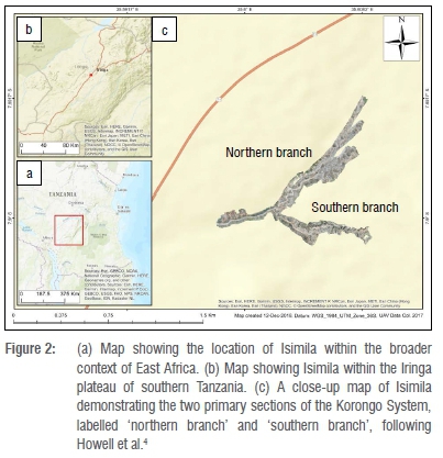
The Isimila Korongo System consists of northern and southern branches, with a stream running from north to south through the valley. Isimila preserves five layers of consolidated sands numbered from the top (Sands 1) to base layer (Sands 5) overlying an early Pleistocene claycrete. The lower beds (Sands 3-5) are thick and largely continuous throughout the northern branch of the Korongo, while the upper beds (Sands 1 and 2) are thinner and present in only the northernmost parts of the northern branch.4 The sediments of Isimila are thought to have been deposited during a period of drying during the Middle Pleistocene.4 The deposition of sandy layers followed by silty clay in the Isimila Formation has been attributed to a cyclic depositional environment by various authors. However, the reconstructions of this environment have differed. The palaeoenvironment of Isimila has been described as lacustrine6, a shallow pond with some drainage out the northern end of the korongo4, and riverine7. Howell et al.4 also argued that the clay capping the upper layers of the Isimila Formation may represent an mbuga environment (a seasonal swamp or marsh).
Excavations in Sands 1 uncovered rich concentrations of stone tools throughout, suggesting a dense and largely continuous occupation by Middle Pleistocene Homo.4 'Crudely finished' tools were interspersed with finely finished hand axes in Sands 1; this combination has been hypothesised to reflect behavioural flexibility in hominins in response to differing environmental conditions.8(p.351) Two occupation areas (H20 and J12 trenches) were identified in Sands 2 and had a lower density of artefacts than Sand 1 or 3, suggesting sparse occupation by hominins.4 Excavations in Sands 3 uncovered a generalised dense occupation, including three occupation areas (trenches H15, K18 and K19).4 Excavations in Sands 4 and 5 uncovered a number of small implements and fauna.4,5,9
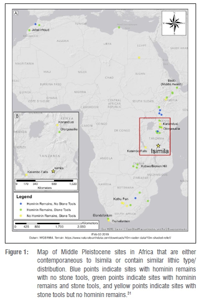
Isimila has been compared to Olorgesailie and Kariandusi in Kenya, as well as to Kalambo Falls in Zambia, based on similarities in their chronologies and lithic typologies (Figure 1).4,5,8,10 Recent discoveries at Olorgesailie yielded some of the earliest known Middle Stone Age (MSA) artefacts in East Africa.11-13 Moreover, optically stimulated luminescence dating of deposits at Kalambo Falls suggests multiple, temporally distinct occupations beginning as early as 500 kya.14 Isimila may provide a unique temporal and geographic window into the Acheulean at the Acheulean-MSA transition in East Africa, although new dates are necessary to better contextualise the site. Within Tanzania, the lower beds of Isimila (Sands 3-5) are broadly contemporaneous with the Ngaloba Beds at Laetoli15, which yielded Laetoli Hominid 18 (LH 18), a partial Homo cranium16,17. While no hominin remains have been found at Isimila, the region preserves an extensive archaeological sequence ranging from the Middle Pleistocene to the Iron Age.18 As such, Isimila and the broader region provide a unique window into hominin behaviour, ecology and palaeoenvironments at a critical time period in human evolution and more recent human history.
Methods
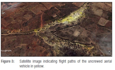
A DJI Phantom 4 Pro+ quadcopter (DJI, Shenzen, China) equipped with an onboard high-definition camera optimised for aerial image capture (i.e. a wide-angle, non-fisheye lens; Supplementary table 1) was used for the aerial survey and data capture in July 2017. Previously published maps and a preliminary pedestrian survey were used to plan flight paths (Figure 3). Start and end points were recorded on the ground using a handheld GPS unit. The end point of each flight was used as the starting point for each subsequent flight. In total, 12 survey sessions were conducted at two different altitudes: 6 sessions at 40 m and 6 sessions at altitudes ranging from 10 m to 20 m.
The uncrewed/unmanned aerial vehicle (UAV) was piloted manually using its native software (DJI GO 4v. 4.1.18, DJI, 2017) to set the altitude, velocity, camera positioning and capture parameters, and to monitor the flight path during data capture. Live video tracking was used to capture images during flight. The video footage from the UAV was reviewed in the field and used to identify geological features, sedimentary changes and potential areas of interest for pedestrian survey.
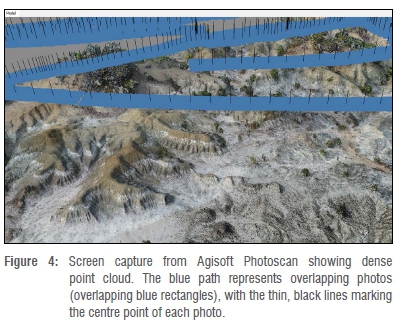
Still photos were extracted from video obtained during flight sessions. GPS coordinates and altitude data tracked by the UAV were embedded in metadata for each still image. Blurry or out of focus images were manually removed. Photos were then imported into Agisoft Photoscan Pro (v 1.4.1, Agisoft, 2018); for processing parameters and workflow see Supplementary table 1. Initially, photos were aligned to create a sparse point cloud of tie points. A dense point cloud was then created to reconstruct the three-dimensional parameters of the coverage area (Figure 4).
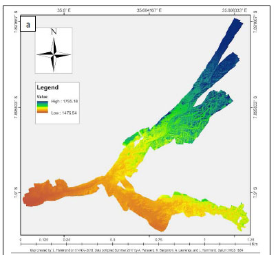
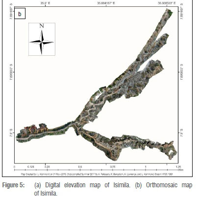
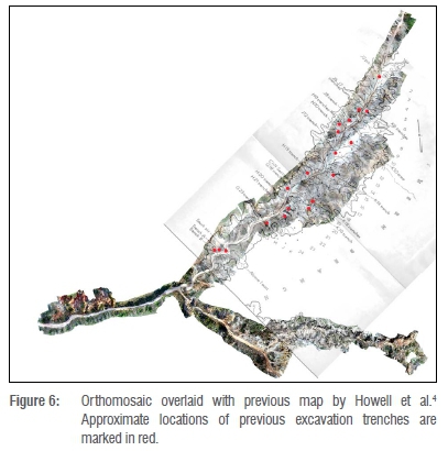
The dense point cloud (Supplementary table 1) was manually edited to remove errant points, areas of heavy noise and unnecessary coverage outside of the basin. A digital elevation model - that is, a three-dimensional representation of the elevation and terrain of the surface (Figure 5a) - was created from the dense point cloud and used to generate the top-down orthomosaic, a series of overlapping georeferenced images used to build a scaled map (Figure 5b, Supplementary table 1), both of which were then imported into ArcMap (v. 10.5, ESRI, 2016), where they were cleaned and legends were added. A hill shade of z-value 1 was added to enhance relief appearance in the Korongo System. An overlay map was created to compare site topography in 19624 and that in 2017 (Figure 6). The orthomosaic was digitally aligned to the map from Howell et al.4 using GNU Image Manipulation Program (v. 2.10.4, GIMP, 2018). Trenches and pits were cross-referenced and plotted using approximate locations.
Results
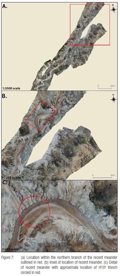
The overlaid excavation map (Figure 6) demonstrates shifts in the course of the Isimila stream. A horseshoe-shaped meander in the northern branch which appeared on the original map has been largely eroded away. The previous course of the stream now appears as a large sandy bank on the western side of the northern branch. A new meander is present to the north, cutting directly into exposed tool-bearing beds. Based on comparisons with the original excavation maps, the new meander may be washing over the location of the 1959 H10 trench (Figure 7).4
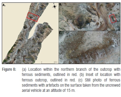
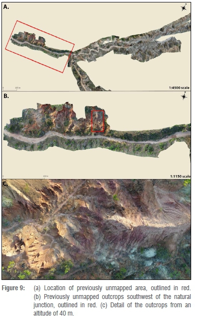
The aerial survey showed undocumented sediment exposures and geological differences within the basin. In the northern branch, an unexcavated area of dark, ferrous sediments was found to have substantial lithic deposits (Figure 8). Additionally, a new region of lithic-bearing red sediments, dissimilar to those in the central part of the Korongo, was identified approximately 200 m south of the southernmost extent of the previous maps (Figure 9).
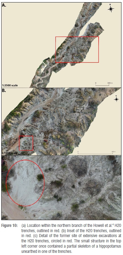
The majority of stone tool surface assemblages are located in the central northern branch of the Korongo (Supplementary figure 1). The large concentrations of lithics and debris in this area may be a result of significant erosion from the Isimila stream. While surface assemblages are present outside of this potential floodplain, they cover smaller surface areas. Most previous excavation trenches are located in areas where there are dense accumulations on the surface today. However, the areas of trenches H20 and K14 have fewer lithics on the modern surface, which may be a result of artefacts from these areas being collected during previous excavations (Figure 10).
Discussion
Uncrewed aerial vehicles provide a higher-resolution alternative to satellite imagery and are more versatile than traditional aerial photogrammetry or mapping.19 As demonstrated by recent work using UAVs at Olduvai Gorge in Tanzania20 and in the Turkana Basin, Kenya21, aerial survey and mapping enhances research by recording new sites and areas of geological and archaeological interest. The high-resolution UAV map of Isimila presented here enables collaborative efforts between research teams to help answer future questions about the site, including aspects of hominin behaviour and its interaction with a shifting palaeoenvironment. Using UAV data, we identified significant changes to surface topography at Isimila over the last half century, including shifts in the course of the Isimila stream and new perspective on the distribution of stone tools and raw materials.
Howell et al.4 proposed that the close association of stone tools to surrounding debris represented short-distance raw material transport. The orthomosaic presented here shows dense clusters of raw material and artefacts, possibly supporting the hypothesis of Howell et al.4 However, the association of artefacts and raw material in clustered surface assemblages in the heavily eroded central portion of the northern branch may be the result of erosional processes. Additionally, new lithic-bearing deposits were identified in previously unmapped southern exposures. If the centre of Isimila, located in the northern branch, was primarily a manufacturing area next to a reliable water source, inhabited sites may be located on the periphery, possibly in the new southern exposures identified here.
Seasonal erosion and changes in the course of the Isimila stream over the last 50 years may have washed away unexcavated lithic deposits. This possibility highlights the need for long-term repeated aerial survey and mapping. Future UAV mapping has the potential to further examine the effects of seasonal erosion and the resulting changes to site topography. Moreover, understanding the effects of natural and anthropogenic change is essential for site conservation. While Tanzania has a lengthy history of issues surrounding archaeological conservation and management,22-25 UAV mapping has yet to be used as part of a management plan. Although Isimila is a managed archaeological site, conservation risks from human activity, erosion and archaeological excavation persist.26,27 Annual UAV mapping and collaborative efforts with researchers and the local communities would advance research and conservation efforts in that any changes within the Isimila Korongo System, particularly in terms of sediment starving or erosions, could easily be detected and mitigated.
Conclusions
Isimila is the subject of renewed research, including excavation and extensive survey, by multiple independent research teams.28-31 The open-access orthomosaic map presented here represents a unique tool for coordinating research between teams working in different parts of the site. The open-access data set presented includes a digital elevation model, orthomosaic, previous excavation overlay map and supplementary material.32 This work provides a baseline for future work and conservation efforts at Isimila. Additionally, we identify major changes to site topography, erosional effects and new archaeological deposits. In a collaborative effort, we ask fellow researchers to submit GPS data of excavation, surface collection and areas of geological interest to a separate open-access orthomosaic.33 This map33 will be updated with new data submissions and will serve as an open-access research tool.
Acknowledgements
We thank the University of Colorado Denver (Office of Research Services and CLAS CRISP 2016/2017 Grants) which made this study possible, Ms Digna Tillya (Director of Antiquities) and Mr Anthony Tibaijuka (Assistant Director, Research) for their support in permitting and providing knowledge of the area, the Antiquities Division of the Ministry of Natural Resources and Tourism for issuing us the Antiquities Excavation Licence, the Commission for Science and Technology (permit no. 2017-234-NA-2016-115), and all the staff at Isimila Stone Age Site. We thank Jonathan Kent, Neffra Matthews, Bonny Ford and Rachael Bible for their valuable comments on earlier drafts. We also thank the students and staff of the 2017 University of Colorado Denver-Tanzanian Field School. Special thanks go to Masoud Kafene, Richard Nzemya, Tony Emmanuel and the insurmountable Faru and Bighorn for always getting us to where we needed to go. We are especially indebted to Dennis Van Gerven and Claudia Blood Van Gerven for their continued support and help on this project. Lastly, we thank the late Simon Mataro for his contributions over the years.
Authors' contributions
K.B.: Conceptualisation, methodology, data collection, data curation, writing - the initial draft, writing - revisions, student supervision, project leadership, project management; A.B.L.: Conceptualisation, data collection, writing - the initial draft, writing - revisions; A.J.P.: Conceptualisation, methodology, data collection, data analysis, data curation, writing - the initial draft, writing - revisions, student supervision, project management; L.J.H.: Methodology, data collection, data analysis, writing - the initial draft, writing - revisions; E.M.: Student supervision, project leadership, funding acquisition; H.T.B.: Writing - revisions, student supervision, funding acquisition; C.M.M.: Conceptualisation, data curation, writing - revisions, student supervision, project leadership, funding acquisition.
References
1.Howell FC, Cole GH, Kleindienst MR, Szabo BJ, Oakley KP. Uranium-series dating of bone from the Isimila Prehistoric Site, Tanzania. Nature. 1972;237(5349):51. https://doi.org/10.1038/237051a0 [ Links ]
2.Van Riet Lowe C. A new African Acheul Stage IV site in Tanganyika. S Afr Archaeol Bull. 1951;6(24):94-98. https://doi.org/10.2307/3886803 [ Links ]
3.Howell FC. A preliminary note on a prehistoric donga (Maclennan's Donga) in central Tanganyika. S Afr Archaeol Bull. 1955;10(38):43-52. https://doi.org/10.2307/3887057 [ Links ]
4.Howell FC, Cole GH, Kleindienst MR. Isimila: An Acheulian occupation site in the Iringa Highlands, Southern Highlands Province, Tanganyika. Actes du IVe Congrès panafricain de préhistoire et de l'étude du quaternaire. 1962:43-80. [ Links ]
5.Cole GH, Kleindienst MR. Further reflections on the Isimila Acheulian. Quat Res. 1974;4(3):346-355. https://doi.org/10.1016/0033-5894(74)90021-0 [ Links ]
6.Bishop WW. The Later Tertiary and Pleistocene in Eastern Equatorial Africa. In: Howell FC, Bourliére F, editors. African ecology and human evolution. Chicago, IL: Aldine Publishing Company; 1963. p. 246-275. [ Links ]
7.Hansen CL, Keller CM. Environment and activity patterning at Isimila Korongo, Iringa District, Tanzania: A preliminary report. Am Anthropol. 1971;73(5):1201-1211. https://doi.org/10.1525/aa.1971.73.5.02a00190 [ Links ]
8.Kleindienst MR. Variability within the Late Acheulian Assemblage in Eastern Africa. S Afr Archaeol Bull. 1961;16(62):35-52. https://doi.org/10.2307/3886868 [ Links ]
9.Coryndon SC, Gentry AW, Harris JM, Hooijer DA, Maglio VJ, Howell FC. Mammalian remains from the Isimila Prehistoric Site, Tanzania. Nature. 1972;237(5353):292. https://doi.org/10.1038/237292a0 [ Links ]
10.Howell FC, Clark JD. Acheulian hunter-gatherers of sub-Saharan Africa. In: Howell FC, Bourliére F, editors. African ecology and human evolution. Chicago, IL: Aldine Publishing Company; 1963. p. 458-533. [ Links ]
11.Potts R, Behrensmeyer AK, Faith JT, Tryon CA, Brooks AS, Yellen JE, et al. Environmental dynamics during the onset of the Middle Stone Age in eastern Africa. Science. 2018;360(6384):86-90. https://doi.org/10.1126/science.aao2200 [ Links ]
12.Deino AL, Behrensmeyer AK, Brooks AS, Yellen JE, Sharp WD, Potts R. Chronology of the Acheulean to Middle Stone Age transition in eastern Africa. Science. 2018;360(6384):95-98. https://doi.org/10.1126/science.aao2216 [ Links ]
13.Brooks AS, Yellen JE, Potts R, Behrensmeyer AK, Deino AL, Leslie DE, et al. Long-distance stone transport and pigment use in the earliest Middle Stone Age. Science. 2018;360(6384):90-94. https://doi.org/10.1126/science.aao26461. [ Links ]
14.Duller GAT, Tooth S, Barham L, Tsukamoto S. New investigations at Kalambo Falls, Zambia: Luminescence chronology, site formation, and archaeological significance. J Hum Evol. 2015;85:111-125. https://doi.org/10.1016/j.jhevol.2015.05.003 [ Links ]
15.Manega PC. Geochronology, geochemistry and isotopic study of the Plio-Pleistocene hominid sites and the Ngorongoro Volcanic Highland in northern Tanzania [PhD dissertation]. Boulder, CO: University of Colorado at Boulder; 1993. [ Links ]
16.Magori CC, Day MH. Laetoli Hominid 18: An early Homo sapiens skull. J Hum Evol. 1983;12(8):747-753. https://doi.org/10.1016/S0047-2484(83)80130-4 [ Links ]
17.Day MH, Leakey MD, Magori C. A new hominid fossil skull (L.H. 18) from the Ngaloba Beds, Laetoli, northern Tanzania. Nature. 1980;284(5751):55-56. https://doi.org/10.1038/284055a0 [ Links ]
18.Biittner KM, Sawchuk EA, Miller JM, Werner JJ, Bushozi PM, Willoughby PR. Excavations at Mlambalasi Rockshelter: A terminal Pleistocene to recent Iron Age record in southern Tanzania. Afr Archaeol Rev. 2017;34(2):275-295. https://doi.org/10.1007/s10437-017-9253-3 [ Links ]
19.Nikolakopoulos KG, Soura K, Koukouvelas IK, Argyropoulos NG. UAV vs classical aerial photogrammetry for archaeological studies. J Archaeol Sci Rep. 2017;14:758-773. https://doi.org/10.1016/j.jasrep.2016.09.004 [ Links ]
20.Jorayev G, Wehr K, Benito-Calvo A, Njau J, De la Torre I. Imaging and photogrammetry models of Olduvai Gorge (Tanzania) by unmanned aerial vehicles: A high-resolution digital database for research and conservation of Early Stone Age sites. J Archaeol Sci. 2016;75:40-56. https://doi.org/10.1016/j.jas.2016.08.002 [ Links ]
21.Evans A, Sparrow T, Leakey L, Wilson A, Donahue R. Transforming the search for human origins using new digital technologies, low altitude imaging, and citizen science. In: Jennings B, Gaffney C, Sparrow T, Gaffney S, editors. Proceedings of the 12th International Conference of Archaeological Prospection. Bradford, UK: Archaeopress Archaeology; 2017. p. 66-69. [ Links ]
22.Demas M, Agnew N. Decision making for conservation of archaeological sites: The example of the Laetoli hominid trackway, Tanzania. In: Agnew N, Bridgland J, editors. Of the past, for the future: Integrating archaeology and conservation. Proceedings of the Conservation Theme at the 5th World Archaeological Congress; 2003 June 22-26; Washington DC, USA. Los Angeles, CA: The Getty Conservation Institute; 2006. p. 64-72. [ Links ]
23.Libsekal Y. Multiplying and sharing heritage values: Planning conservation and site management at the Acheulean sites of Buya, Eritrea. Conserv Manage Archaeol Sites. 2008;10(3):251-263. https://doi.org/10.1179/175355209X452796 [ Links ]
24.Musiba CM, Mabula A, Selvaggio M, Magori CC. Pliocene animal trackways at Laetoli: Research and conservation potential. Ichnos. 2008;15(3-4):166-178. https://doi.org/10.1080/10420940802470383 [ Links ]
25.Biittner KM, Willoughby PR. Working with local communities and managing cultural heritage in Iringa Region, Tanzania. S Afr Archaeol Rec. 2012;36:36-39. [ Links ]
26.Bushozi PM. Towards sustainable cultural heritage management in Tanzania: A case study of Kalenga and Mlambalasi Sites in Iringa, Southern Tanzania. S Afr Archaeol Bull. 2014;69(200):136-141. Available from: http://www.jstor.org/stable/43868708 [ Links ]
27.Tillya D. Preservation of the Stone Age site of Isimila, Tanzania. Conserv Manage Archaeol Sites. 1996;1(4):243-246. https://doi.org/10.1179/135050396793139015 [ Links ]
28.Bushozi PGM. The Acheulean of Isimila, Iringa (South Tanzania). In: The Cradle of Humankind. Madrid: Instituto de Evolución en Africa, IDEA; 2014. [ Links ]
29.Cole J, Bushozi PM, Bite M, McNabb J, Kwekason A. Contextualizing the Stone Age Site of Isimila. Dodoma: Ministry of Natural Resources and Tourism, Tanzania; 2015. [ Links ]
30.Curran SC, Patton PE, Mtelea C. Renewed explorations of the Mid-Pleistocene Site, Isimila, Tanzania. In: Abstracts of the 2018 Paleoanthropology Society Meeting; 2018 April 10-11; Austin, Texas, USA. p. A9. [ Links ]
31.Pelissero AJ, Bergstrom K, Hammond LJ, Lawrence AB, Bunn HT, Musiba CM. Drone mapping of Isimila, Tanzania: The implications for future research into Mid-Pleistocene Homo behavior. In: Abstracts of the 2018 Paleoanthropology Society Meeting; 2018 April 10-11; Austin, Texas, USA. p. A26.ss 1. [ Links ]
32.Bergstrom K, Lawrence AB, Pelissero AJ, Hammond L, Maro E, Bunn HT, et al. UAV Map of Isimila, Tanzania [data set]. Zenodo. Version 1. https://doi.org/10.5281/zenodo.1470770 [ Links ]
33.Bergstrom K, Lawrence AB, Pelissero AJ, Hammond L, Maro E, Bunn HT, et al. Collaborative UAV-based orthomosaic of Isimila, Tanzania [data set]. Zenodo. Version 1. https://doi.org/10.5281/zenodo.1470781 [ Links ]
 Correspondence:
Kersten Bergstrom
Email: kersten.bergstrom@tamu.edu
Received: 04 Jan. 2019
Revised: 22 Feb. 2019
Accepted: 11 Mar. 2019
Published: 30 July 2019
EDITOR: Maryna Steyn
FUNDING: University of Colorado Denver Office of Research Services and CLAS CRISP 2016/2017 Grants
Supplementary Material
The supplementary file is available in pdf: [Supplementary file]
The open data set is available here: [Open data set]

