


Servicios Personalizados
Articulo
 Inglés (pdf)
 Articulo en XML
 Referencias del artículo
Indicadores

Links relacionados
-
 Citado por Google
 -
 Similares en Google
Compartir

 Permalink
South African Journal of Science
versión On-line ISSN 1996-7489
versión impresa ISSN 0038-2353
S. Afr. j. sci. vol.115 no.5-6 Pretoria may./jun. 2019
http://dx.doi.org/10.17159/sajs.2019/6170
NEWS AND VIEWS
A new era for marine forecasting in South Africa
Tamaryn MorrisI; Christo RautenbachI, II
IMarine Unit, South African Weather Service, Cape Town, South Africa
IIDepartment of Oceanography and Marine Research Institute, University of Cape Town, Cape Town, South Africa
The International Convention for the Safety of Life at Sea (SOLAS) was established in 1914 as a consequence of the sinking of the RMS Titanic in 1912, one of the deadliest peacetime marine disasters and which resulted in the loss of more than 1500 lives. However, the International Meteorological Organisation, born as a direct result of an international maritime conference in 1853, had already initiated weather information for shipping safety, but this was information that the RMS Titanic did not believe it needed to heed. In 1950, the World Meteorological Organization (WMO) took on the role of the International Meteorological Organisation, enhancing SOLAS, and establishing METAREAs (geographical oceanic regions in which meteorological information is transmitted to ships) with global responsibilities.
South Africa is responsible for providing marine weather-related information and warnings for the world's second largest METAREA (METAREA VII), which extends from 6°S to the Antarctic continent and from 20°W to 80°E (note from 55°E to 80°E, only south of 30°S falls within the South African METAREA). SOLAS products related to extreme and potentially life-threatening events are disseminated through the Global Marine Distress and Safety Service (GMDSS) and this dissemination is a key objective of the South African Weather Service (SAWS).
Moreover, the SAWS helps neighbouring coastal African countries to assist the ever-growing number of non-SOLAS vessels (i.e. vessels that do not typically undertake international voyages, but must adhere to safety standards according to their size, type and operations). The rapidly increasing coastal populations around the world that are at risk from marine hazards are also an emerging priority. An example is the recent, and devastating, Cyclone Idai, which tore through the port city of Beira in Mozambique. But are we at SAWS doing the very best we can? We believe that the Marine Unit and our novel forecasting system is innovative and extremely helpful.
The oceans are extensively used for commerce and recreation. Shipping is by far the dominant method for global trade and trillions of US dollars pass through the world's harbours annually. The oceans also provide mineral resources such as gas and oil, while precious minerals such as diamonds are mined on the seafloor. Through recreational activities (e.g. ocean liners and sailing yachts, surfers, kite-surfers and beach-goers), the coasts of many countries receive millions of visitors every year - an industry which supports local communities and economies. And, it should be noted, in most countries that have a coastline, much of the population typically lives on the coast.
To manage these issues of safety, an efficient and dynamic marine service is needed - one that can provide essential information that ranges from daily forecasts of passing weather systems and that might impact on safe shipping, to the more extreme and potentially life-threatening events. The latter might include storm surge and destructive wave activity along the coast, hazardous seas in the METAREA, or Marginal Ice Zone navigation and warnings in the Antarctic region.
Marine services not only contribute to shipping information and safety, but also provide information to coastal engineers and environmental managers about best practices of ensuring coastal longevity. Population trends and changing climate conditions have increased the vulnerability of coastal populations and infrastructure, and these are amplified by the effects of weather and conditions in the ocean. Technology has also changed rapidly in the last decade, vastly improving the services historically provided. In addition, effective access, dissemination and alerting systems are critically important for a national meteorological service. For no matter how accurate products are, they must be used wisely in decision-making processes. The ability to facilitate reliable, timely access to information is critical to ensuring that products and services are relevant.
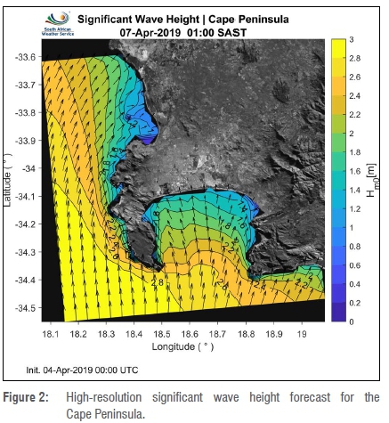
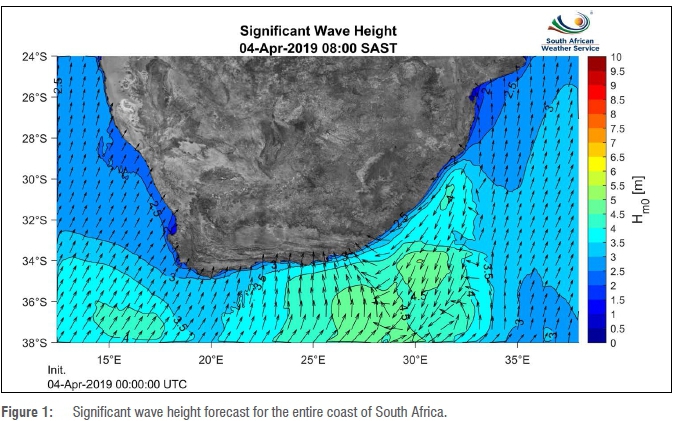
The Marine Unit of the SAWS has developed a dynamic marine forecasting website for all coastal and marine users. The website is primarily used to disseminate operational high-resolution wave, storm surge and tidal forecasts (72 hours), and additional products are planned as the Unit and its website develop. Figure 1 illustrates the regional wave forecast with a high-resolution snapshot of the Cape Peninsula (Figure 2). This forecast allows coastal and offshore ocean users, disaster management structures and municipal authorities to prepare for potentially damaging situations in real-time. Our forecasts will also assist small-scale commercial fishermen and recreational ocean users, such as surfers, kayakers and long-distance swimmers, to plan their marine activities in the short term. In addition, the website showcases the research that underpins the Marine Unit's products and services. Projects range from those related to infrastructure and observations (such as ocean surface drifters, Argo floats and sea-ice drifters and observations) to the high-resolution numerical prediction of water levels and waves.
The Marine Unit is a young and energetic team, comprising an applied mathematician, physical oceanographers and marine meteorologists, with technical support. The Marine Master Plan that explains the Unit's objectives and deliverables is new, having been approved by the Executive Board of SAWS little more than a year ago. Yet already the Unit has doubled in capacity and has exceeded expectations within the first year. In addition, the Unit, working under the technical guidance of the WMO and the International Oceanographic Commission, has been requested to develop a marine services implementation plan that is coherent with the implementation plan of the WMO Strategy for Service Delivery and considers practices from the Global Data Processing and Forecasting System.
Users are finding ways to gather and display information in a manner that meets their own needs, regardless of the SAWS's original intention. The way in which products and services are delivered has to change to accommodate risk-based products that are linked to the capacity of users to interpret information. To improve service delivery to users, marine meteorological and climate observations and research must precede the rollout of any new or improved operational products. Rigorous testing of predictive models must occur prior to the use of the product in an operational setting, once their configurations have been improved. Thus, ongoing research should be seen as integral to the service delivery process.
Strong operational and academic collaborations underpin the Marine Unit's success and range from universities and research councils and academic institutions, to environmental consultancy groups, local and national government departments, and coastal engineering companies. The Unit is keen for all users of met-ocean information to peruse the website at www.weathersa.co.za/marine/. A formal survey of different user communities will be initiated shortly to determine the usability and general perception of the portal. Through the survey we hope to make improvements as needed, and our ideal is to service as large a met-ocean community as possible. Informally, marine users have already commented favourably on having 'old-school' synoptic charts and SOLAS communications available under the 'Observations' tab because many seafarers still rely on these systems for their work, particularly further out from the coastline. Other users have been pleased with the coastal automatic weather station map available under the 'Products and Services' tab (observational data), which assists students, engineering teams and coastal users. Through the development of a map and with relevant feedback from stakeholders, the Marine Unit is also able to motivate for additional automatic weather stations in key areas, such as False Bay, where currently only one station, at Strand, is available. The Unit has also begun work on sea-ice observations and, in July 2019, will be deploying sea-ice drifters to understand how sea-ice drifts in the Antarctic region directly south of South Africa may help us to forecast sea-ice movement in the future. Finally, the Unit aims eventually, through the portal, to make available for all users daily, a Forecaster's Synopsis which will summarise what is forecast through the wave, storm surge and tidal forecasts, coupled with information from coastal observations and meteorological forecasts. During extreme events such as storm surges during which flooding of terrestrial regions, potential loss of life and damage to infrastructure may become a possibility, these forecasts will be updated more regularly to assist in informing disaster management and similar organisations.
Should you be keen to participate in our surveys, or would just like to provide feedback, please contact the Marine Coordinator, Tamaryn Morris at tamaryn.morris@weathersa.co.za. We look forward to continued and enhanced engagements with our coastal and ocean user communities.
 Correspondence:
Tamaryn Morris
Email: tamaryn.morris@weathersa.co.za
PUBLISHED: 29 May 2019

