


Services on Demand
Article
 English (pdf)
 Article in xml format
 Article references
Indicators

Related links
-
 Cited by Google
 -
 Similars in Google
Share

 Permalink
South African Journal of Science
On-line version ISSN 1996-7489
Print version ISSN 0038-2353
S. Afr. j. sci. vol.114 n.3-4 Pretoria Mar./Apr. 2018
http://dx.doi.org/10.17159/sajs.2018/a0247
COMMENTARY
Working together for our oceans: A marine spatial plan for Algoa Bay, South Africa
Rosemary A. DorringtonI, II; Amanda T. LombardIII; Thomas G. BornmanIV, V; Janine B. AdamsV; Hayley C. CawthraVI, VII; Shaun H.P DeyzelIV, VIII; Wayne S. GoschenIV; Kenneth LiuIX; Jacques Mahler-CoetzeeX; Gwynneth F. MatcherII, XI; Christopher McQuaidXII; Shirley Parker-NanceIV, XI; Angus PatersonII; Renzo PerissinottoXIII; Francesca PorriII, XIV; Michael RobertsXV; Bernadette SnowXVI; Patrick VranckenXVII
IDST/NRF SARChI Chair in Marine Natural Products, Department of Biochemistry, Microbiology and Biotechnology, Rhodes University, Grahamstown, South Africa
IISouth African Institute for Aquatic Biodiversity (SAIAB), Grahamstown, South Africa
IIIDST/NRF SARChI Chair in Marine Spatial Planning, Institute for Coastal and Marine Research, Nelson Mandela University, Port Elizabeth, South Africa
IVSouth African Environmental Observation Network, Elwandle Coastal Node, Port Elizabeth, South Africa
VDepartment of Botany, Institute for Coastal and Marine Research, Nelson Mandela University, Port Elizabeth, South Africa
VIMarine Geoscience Unit, Council for Geoscience, Bellville, South Africa
VIICentre for Coastal Palaeoscience, Nelson Mandela University, Port Elizabeth, South Africa
VIIIDepartment of Zoology, Institute for Coastal and Marine Research, Nelson Mandela University, Port Elizabeth, South Africa
IXDepartment of Geology, University of Fort Hare, Alice, South Africa
XNelson Mandela School of Law, University of Fort Hare, East London, South Africa
XIDepartment of Biochemistry and Microbiology, Rhodes University, Grahamstown, South Africa
XIIDST/NRF SARChI Chair in Marine Ecosystem Research, Department of Zoology and Entomology, Rhodes University, Grahamstown, South Africa
XIIIDST/NRF SARChI Chair in Shallow Water Ecosystems, Institute for Coastal and Marine Research, Nelson Mandela University, Port Elizabeth, South Africa
XIVDepartment of Zoology and Entomology, Rhodes University, Grahamstown, South Africa
XVDepartment of Oceanography, Institute for Coastal and Marine Research, Nelson Mandela University, Port Elizabeth, South Africa
XVIDepartment of Development Studies, Institute for Coastal and Marine Research, Nelson Mandela University, Port Elizabeth, South Africa
XVIIDST/NRF SARChI Chair in the Law of the Sea and Development in Africa, Institute for Coastal and Marine Research, Nelson Mandela University, Port Elizabeth, South Africa
Keywords: community of practice; systematic biodiversity plan; oceanography; social-ecological system; system dynamics; marine law; ocean governance
Southern Africa occupies a critical position within the southern hemisphere for the study of broadscale global change and the three oceans around South Africa (the Atlantic, Indian and Southern Oceans) play a vital role in determining local and regional climate and weather patterns. Oceans and coasts also provide various resources and services (e.g. food and carbon sequestration), but these services are threatened by human activities. Uncertainty of the impact and consequences of these anthropogenic activities makes it problematic to manage marine resources. Given the recent global emphasis on the development of 'ocean economies', the exploitation of living (fisheries, aquaculture and tourism) and non-living (oil and gas, minerals, energy) marine resources should be on a scale that is socially and economically justifiable and ecologically sustainable.
In 2014, 'Operation Phakisa' was launched in South Africa as an initiative to accelerate execution of the National Development Plan.1 The primary focus of Phakisa is to unlock the economic potential of South Africa's oceans.2 This will be achieved through the 'implementation of an overarching, integrated ocean governance framework for sustainable growth of the ocean economy that will maximise socio-economic benefits while ensuring adequate ocean environmental protection' by 2019. Marine spatial planning (MSP) is a key component of this integrated governance framework, and the development of MSP legislation during 2016 was prioritised as 'critical' to achieving the Operation Phakisa objectives. Accordingly, the Department of Environmental Affairs (DEA) published the Marine Spatial Planning Bill (2017)3 'to provide a framework for marine spatial planning in South Africa's waters; to provide for the development of the marine spatial plan; to provide for institutional arrangements for the implementation of the marine spatial plan and governance of the use of the ocean by multiple sectors; and to provide for matters connected therewith'.
A Marine Spatial Plan for the South African maritime domain
The MSP Bill provides for a multi-stage approach to develop a Marine Spatial Plan for the South African maritime domain, which may be divided into four bio-geographic marine areas: the East Coast, the South-East Coast, the West Coast and the Prince Edward Islands. According to the MSP Framework,4 South Africa's marine area plans will be prepared sequentially. This framework will allow effort to be focused on one marine area at a time and the consequent experience gained from preparing each plan will be used to refine and improve the preparation (or review) of other plans. To determine the order in which the plans will be prepared, an initial assessment of the priorities for each marine area is required, taking into account the cross-sectoral state of knowledge of system processes and functioning, environmental pressures, human uses and development opportunities. A critical component of the MSP process will be a national data- and information-gathering exercise, in which existing knowledge on social-ecological systems and their interactions will be consolidated. Given that this will be South Africa's first experience of conducting MSP the first plan will allow the MSP process to be fine-tuned for application in subsequent plans.
Algoa Bay as a case study for the first South African Marine Area Plan
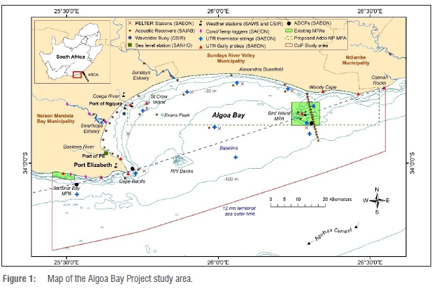
Algoa Bay (Figure 1) is an ideal planning region for a case study, given the substantial body of biophysical data that exists for the area. Research on the physical oceanography began in the 1980s with short-term, fine-scale projects, which led to an increase in knowledge of the Bay system.5-9 The establishment of the South African Environmental Observation Network (SAEON) Algoa Bay Sentinel Site for Long-Term Ecological Research in 2007 has led to the collection of a wealth of data10-12 that has resulted in Algoa Bay being considered the best-monitored coastal area in Africa and in the southern hemisphere. The diversity of habitats, oceanographic processes and the socio-economic reliance on the marine environment in Algoa Bay has provided dynamic natural laboratories for conducting multidisciplinary, multi-institutional field-based research that can be applied to other regions.13 Building on this solid biophysical base, we intend to generate new knowledge on the social-ecological systems in the Bay. Although our planning products will be focused on Algoa Bay, social-ecological systems extend well beyond the Bay (e.g. larval transport, sea-level rise, fisheries benefits).
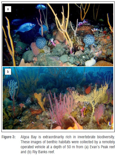
The distribution and ecology of the large fauna of Algoa Bay have been extensively studied since the first description of bird species around the Bird Island complex in 1946 by Courtenay-Latimer and Gibson-Hill14. The focus of research has been mostly on top predators15-21, pelagic fish species22-28, squid29, and the impact of global change on the local fisheries30. Knowledge of the diversity of subtidal benthic macrofauna is less extensive and focused research is more sporadic and mostly limited to observational data obtained by SCUBA at depths of less than 30 m during collection of invertebrate specimens (sponges, tunicates, soft corals) for marine natural product chemistry.31-34 Recent data collected by a remotely operated vehicle through the African Coelacanth Ecosystem Programme suggest that the Bay may support extraordinary invertebrate diversity including numerous novel, undescribed taxa (Parker-Nance and Dorrington, unpublished data).
Information on the biology and ecological dynamics within the shallow subtidal and intertidal zones has two focus areas: sandy beach35-36 and rocky shore ecosystems. Research in both systems has targeted resources used for human consumption and, in the case of rocky shores, also biological invasions.37 These studies mostly have provided information on the genetic and spatial structure of marine assemblages,38,39 and on the early life stage dynamics that characterise the Bay in comparison to the adjacent stretch of open coast. The structure and function of marine species in the Bay differ from those in the adjacent open coast40 such that the dynamics of stock replenishment differ between the two41. Recent developments also suggest the importance of the Bay as an area of larval retention, although behavioural and oceanographic features can further shape population connectivity within this complex system.42,43
Other studies have focused on the diversity of the phytoplankton microbial communities in the Algoa Bay system including diatoms and bacterial communities34,44-46, but knowledge of the true extent of microbial diversity in the Bay and elsewhere along the South African coast is very limited47,48. There have been a number of studies on the Sundays and Swartkops (the two largest estuaries that enter the Bay), including a recent investigation of estuarine microbial communities.49 A preliminary study was undertaken on the sedimentary deposits of the Algoa Bay seafloor in the 1970s.50
The legal regime in the Bay is dominated by the Maritime Zones Act, 1994 (Act 15 of 1994). The Bay has the status of internal waters and because the waters are part of the territory of South Africa, all domestic legislation must be assumed to apply including, for instance, the Marine Traffic Act, 1981 (Act 2 of 1981), the National Ports Act, 2005 (Act 12 of2005), the Marine Living Resources Act, 1998 (Act 18 of 1998), the National Environmental Management Act (NEMA), 1998 (Act 107 of 1998) and the significant amount of environmental legislation that stems from the NEMA, for example, the Integrated Coastal Management Act, 2008 (Act 24 of 2008). The development of the Marine Spatial Plan also needs to take place in accordance with any future MSP legislation (The MSP Bill, 20173). Adding to the legal complexity is the need to take into account the scope of the powers and duties of the provincial legislative and executive bodies and the adjacent coastal municipalities e.g. the Nelson Mandela Bay Metropolitan Municipality. Also relevant is legislation impacting on relevant coastal activities on land including, for instance, the Spatial Planning and Land Use Management Act, 2013 (Act 16 of 2013), as well as maritime safety and security legislation, and their application along the adjacent stretch of coast. The maritime and coastal surface space also articulates with both that which is below the water and that which is above it. Consequently, legislative provisions governing air space (such as the Civil Aviation Act 13 of 2009), as well as defined aspects of the coastal and sub-aqua space (such as underwater cultural heritage under the National Heritage Resources Act 25 of 1999), must be considered and integrated into marine governance frameworks including MSP. We propose here that Algoa Bay should be used as a case study to develop appropriate methods and products to inform the first regional marine area plans. The Bay is an appropriate pilot site because it includes complex scales of governance, human use and biophysical environments, and MSP for this area will likely be scalable to broader areas.
The 'Algoa Bay Project'
In September 2017, we established a South African Research Chair Initiative (SARChI)-led community of practice, including 6 SARChI Professors and 12 senior researchers representing three universities (Rhodes University, Nelson Mandela University and the University of Fort Hare) and three national research institutions - SAEON, the South African Institute for Aquatic Biodiversity (SAIAB), both located within the Eastern Cape, and the Council for Geoscience Marine Geoscience Unit. All members of the new community of practice are actively involved in research in the broad field of marine science, with many studies focusing on the Algoa Bay system. These researchers, together with their research groups and collaborators, provide the transdisciplinary consortium with the critical mass required for the Algoa Bay Project (Figure 2).
MSP is dependent on understanding and managing the complexity of legal and socio-economic requirements on the one hand and environmental considerations (including physical, chemical and biological factors) on the other. Broadly, the Algoa Bay Project is based on three fundamental pillars: (1) a bioregional plan that includes a detailed biophysical map of the region together with data on biodiversity patterns and processes of the system; (2) a governance framework that integrates the complex legal regimes that govern activities in the region, including local, provincial, national and international legal instruments, and (3) a socio-economic plan that addresses stakeholder needs, human use, impacts on ocean and human health, economic value of ocean resources and activities, the valuation of ecosystem services, and the mapping of ecological infrastructure (Figure 2).
In the first phase of the Algoa Bay Project, we will focus on the development of a bioregional plan (using systematic biodiversity planning methods51-53) and a governance framework, while the second phase will be the development of a socio-economic plan, with the ultimate goal being an integrated marine spatial plan.
To embrace novelty, creativity and meaningful transdisciplinarity in this study, we plan to address a major knowledge gap - the development of a system dynamics modelling approach to MSP - within the Algoa Bay social-ecological system. The biophysical, socio-economic and legal systems within the Bay are complex,54 and our approach will be to understand subsystems, and then link them to one another in an integrated system dynamics model. Such a (causal-loop) model will define the relationships between factors in both the coastal and ocean domains across the traditional shoreline boundary, and will allow scenario planning to evaluate the outcomes of different management and global change scenarios. All three pillars of the project (bioregional, governance and socio-economic) will be combined in the final MSP model allowing users (stakeholders) to understand the causal relationships between factors, and to model the impacts of changes in any factor on the system. For example, one could model the impacts of introducing a new ocean zoning system on the total catch of the small pelagic fishery; or the impact of an increase in fishing effort on the prey base of penguins.
A fine-scale bioregional plan and spatial data for Algoa Bay
A critical component of a bioregional plan is the fundamental knowledge of the extent and distribution of biodiversity, the ecosystem processes that sustain this biodiversity, and the anthropogenic factors that use and threaten it. While South African marine biota comprises more than 13 000 species, the majority of which are large bodied, knowledge of microbial (viruses, archaea, bacteria, fungi) and protozoan diversity is considered to be poor to non-existent. 'Moderate knowledge' of benthic macrofauna diversity is confined mainly to species collected from the intertidal and shallow coastal waters.35,55 This knowledge gap will be addressed for the Algoa Bay system by providing high-resolution information on the diversity of microbial communities (archaea, bacteria and phytoplankton) and macrofauna (e.g. sponges, tunicates and bryozoans) as well as invertebrate and fish larvae in habitats extending
from the intertidal to shallow coastal waters and the continental shelf. The result will be a fine-scale biodiversity map of the Algoa Bay system (Figure 1) that will be used to assess the effectiveness of existing and proposed Marine Protected Areas, and to recommend how knowledge gaps can be addressed. The study will also investigate the extent and intensity of anthropogenic impacts (e.g. aquaculture, shipping and used-water inputs) in the Bay, and produce a human-use map for the bioregional planning and systems modelling exercises. This work will build on the broadscale marine protected area planning already undertaken by the South African National Biodiversity Institute (SANBI)56 and South African National Parks (SANParks) in the design of the proposed Addo Elephant National Park Marine Protected Area.
Current knowledge of the oceanography of Algoa Bay is insufficient to fully understand this complex system, and many questions still need to be answered. The multidisciplinary Algoa Bay Project seeks to provide a broad overview of the system by integrating existing data on the oceanography, bathymetry, coastal and marine geology and geomorphology. Knowledge gaps will be filled by targeted studies making use of research platforms available through SAIAB and SAEON. Areas of special interest include upwelling, Agulhas Current influences, swell, long-period waves and internal waves, storm surges, current dynamics of open bays and around capes, thermohaline structures and dynamics, physical and biological properties of fronts, rips, palaeo sea-level calculations and projected future and mega rips, sea-level rise, wind and weather patterns, bathymetric and marine geophysical seafloor mapping, and sediment dynamics and transport.
Also important to the development of a marine bioregional plan is the fundamental understanding of biodiversity movement patterns and ecosystem functioning. Algoa Bay is uniquely influenced by oceanographic features including warm tropical waters from the Agulhas Current and upwelling of cool, nutrient rich bottom waters. In addition, fresh water is fed into the Bay by rivers (largely the Swartkops and Sundays) as well as being fringed by the Alexandria Dunefield (Figure 1). These features, together with the physical geography, combine to provide habitats for a diversity of benthic invertebrate species (Figure 3). Ecosystems of special interest in the region include permanently and temporarily open/closed estuaries, rocky shores, islands, sandy beaches and coastal dunefields, coastal wetlands, peritidal tufa stromatolites as well as the pelagic and benthic ecosystem of the Bay and continental shelf.
The aims of the project are: (1) to map patterns of biodiversity distribution, abundance and composition of Algoa Bay; (2) to identify drivers of habitat segregation, species dispersal and connectivity and (3) to model interactions between indigenous and alien species. Research will focus on the dynamics of changing community structures and ecosystem processes in response to climate change and human-induced factors, such as alien species introductions, land-use change, residential/industrial development and associated pollution. The expected outcomes should include an updated, state-of-the-art assessment of each ecosystem, with high-resolution data across multiple scales of taxa.
The process of developing a marine bioregional plan will proceed in parallel, integrating existing and new knowledge as it becomes available from the biophysical mapping studies. We will apply best-practice systematic planning approaches using available data on biophysical patterns and processes. Data will be sourced from sub-projects 1-3 (Figure 2), spanning all habitats (intertidal to coastal to pelagic) and all levels of biodiversity (genes to ecosystems). Products will include a bioregional plan, but the collation of all spatial information in one format will provide added value. Once spatially explicit socio-economic data become available (Phase 2), the bioregional plan can be iteratively rerun, allowing the quantitative evaluation of trade-offs between human and environmental needs should they conflict, and to develop a transparent and sustainable marine zoning for the Bay. Novel approaches will include cross-realm planning (land to sea), the incorporation of tracking (animal movement), connectivity (e.g. larval transport) and risk (e.g. sea level rise, anthropogenic pollution) data into the plan, and scenario planning within a system dynamics modelling framework.
Legal landscape and development of legislative framework for Algoa Bay
The development of a Marine Spatial Plan for Algoa Bay must take place against the background of the complex legal regime governing activities in Algoa Bay (The Maritime Zones Act, 1994 [Act 15 of 1994]) with respect to internal waters and the territorial sea. Because the waters are part of the territory of South Africa, all domestic legislation applies. The National Environmental Management: Integrated Coastal Management Act, 2008 (Act 24 of 2008) requires that Algoa Bay be managed in an integrated manner. Research will focus on a systematic evaluation of the consequences of the enactment of this Act on legislation and related activities in a specific geographic area. The development of the Marine Spatial Plan will need to take into account the legislative developments regarding the MSP Bill.3 Because the new Act will be the first of its kind in South Africa, a crucial component of this sub-project is to critically discuss the provisions of the Bill, both within the whole internal economy of the Bill and with regard to its relationship with other pieces of legislation, including the Constitution (especially Chapters 2 and 3), as well as with their implementing subordinate legislation.
The development of the Marine Spatial Plan also needs to take into account the scope of the legislative and executive jurisdictions of the Eastern Cape Province and the adjacent coastal municipalities as well as the extent to which they have made use of those jurisdictions. That is in addition to pieces of legislation impacting on relevant coastal activities on land. This research will constitute the first attempt at assessing to what extent both sets of legislation are synchronised and if the steps taken to enforce them are compatible. Finally, research will focus on the legal regime governing coastal and marine tourism and recreation in Algoa Bay (including related underwater and over water space as these spaces articulate with the maritime domain57), as well as the extent to which the Marine Spatial Plan ought to take into account the range of relevant factors affecting good governance of tourism activities on both sides of the low-water mark.
Conclusions
The Algoa Bay Project will develop the first Marine Spatial Plan in South Africa, and feed directly into the process for developing a national Marine Spatial Plan as set out by the MSP Bill (2017).3 The primary recipients of project outputs will be the National MSP Working Group, which has been tasked with producing the Marine Area Plans as set out in the MSP Framework.4 The project will also serve to support refinement and improvement of the process of developing these area plans. In Phase 1, the Algoa Bay Project aims to inform the biophysical and governance components of the overall system dynamics model, while Phase 2 will focus on the socio-economic component. All three components will then be combined in the overarching system dynamics model that can be used as a decision-support tool to design efficient strategies for the sustainable use of the Bay.
National stakeholders involved in Operation Phakisa that will benefit from this project include the Departments of Science and Technology (Marine and Antarctic Research Strategy), Environmental Affairs (the MSP process; Marine Protected Areas), Agriculture, Forestry and Fisheries (sustainable use of ocean resources); Mineral Resources; and Energy (mining, oil and gas exploration). Other important stakeholders include SANBI (Marine Programme), SANParks and the Transnet National Ports Authority which manage the Port Elizabeth and Ngqura harbours. Locally, the main beneficiaries of the project will be the adjacent municipalities (for example, the Nelson Mandela Bay Metropolitan Municipality) as well as civil society58 (which includes the private sector such as fisheries and tourism).
Finally, an important objective of the Algoa Bay Project is to raise the profile of marine science and the potential benefits of the 'Blue Economy' in the Eastern Cape, which is not traditionally known as a centre for marine research and development. This in turn should make the region more attractive for young scientists and entrepreneurs who in turn will help to develop the economic potential of the oceans and coasts of the Eastern Cape in a sustainable manner, to the benefit of all who live there.
References
1. National Planning Commission. National Development Plan 2030: Our future - make it work. Pretoria: National Planning Commission; 2012. Available from: https://www.gov.za/sites/www.gov.za/files/Executive%20Summary-NDP%202030%20-%20Our%20future%20-%20make%20it%20work.pdf [ Links ]
2. Zuma J. Address by President Zuma at the Operation Phakisa: Unlocking the economic potential of the ocean economy open day; 2014 October 15; International Convention Centre, Durban, South Africa. Available from: http://www.operationphakisa.gov.za/cc/Documents/Open%20Day%20Operation%2 0Phakisa%20President%20Speech.pdf. [ Links ]
3. Marine Spatial Planning Bill [B 9-2017]. Department of Environmental Affairs. Government Gazette no. 40726 of 28 March 2017. [ Links ]
4. Draft Marine Spatial Planning Framework. Department of Environmental Affairs. Government Gazette no. 40219 of 19 August 2016. [ Links ]
5. Schumann EH, Ross GJ, Goschen WS. Cold water events in Algoa Bay and along the Cape south coast, South Africa, in March/April 1987. S Afr J Sci. 1988;84:579-583. [ Links ]
6. Goschen WS, Schumann EH. Ocean current and temperature structures in Algoa Bay and beyond in November 1986. Afr J Marine Sci. 1988;7(1):101-116. https://doi.org/10.2989/025776188784379198 [ Links ]
7. Roberts MJ. Dispersion of a buoyant effluent discharged into the nearshore waters of Algoa Bay [MSc thesis]. Port Elizabeth: University of Port Elizabeth; 1990. [ Links ]
8. Goschen WS, Schumann EH. An Agulhas Current intrusion into Algoa Bay during August 1988. Afr J Marine Sci. 1994;14(1):47-57. https://doi.org/10.2989/025776194784286914 [ Links ]
9. Lutjeharms JR, Cooper J, Roberts M. Upwelling at the inshore edge of the Agulhas Current. Cont Shelf Res. 2000;20(7):737-761. https://doi.org/10.1016/S0278-4343(99)00092-8 [ Links ]
10. Roberts MJ. Coastal currents and temperatures along the eastern region of Algoa Bay, South Africa, with implications for transport and shelf-bay water exchange. Afr J Mar Sci. 2010;32(1):145-161. https://doi.org/10.2989/1814232X.2010.481153 [ Links ]
11. Goschen WS, Schumann EH. The physical oceanographic processes of Algoa Bay, with emphasis on the western coastal region. IMT document number: PO106-10000-730002. Pretoria/Cape Town: South African Environmental Observation Network (SAEON)/ the Institute of Maritime Technology (IMT); 2011. [ Links ]
12. Goschen WS, Schumann EH, Bernard KS, Bailey SE, Deyzel SH. Upwelling and ocean structures off Algoa Bay and the south-east coast of South Africa. Afr J Mar Sci. 2012;34(4):525-536. https://doi.org/10.2989/1814232X.2012.749810 [ Links ]
13. Goschen WS, Bornman TG, Deyzel SH, Schumann EH. Coastal upwelling on the far eastern Agulhas Bank associated with large meanders in the Agulhas Current. Cont Shelf Res. 2015;101:34-46. https://doi.org/10.1016/j.csr.2015.04.004 [ Links ]
14. Courtenay-Latimer M, Gibson-Hill CA. A preliminary note on the Bird Island group in Algoa Bay. Ostrich. 1946;17(2):75-86. https://doi.org/10.1080/00306525.1946.9638902 [ Links ]
15. Randall EW. Species diversity and size ranges of cephalopods in the diet of jackass penguins from Algoa Bay, South Africa. Afr Zool. 1981;16(3):163-166. https://doi.org/10.1080/02541858.1981.11447752 [ Links ]
16. Batchelor AL, Ross GJ. The diet and implications of dietary change of Cape gannets on Bird Island, Algoa Bay. Ostrich. 1984;55(2):45-63. https://doi.org/10.1080/00306525.1984.9634757 [ Links ]
17. Karczmarski L. Group dynamics of humpback dolphins (Sousa chinensis) in the Algoa Bay region, South Africa. J Zool. 1999;249(3):283-293. https://doi.org/10.1111/j.1469-7998.1999.tb00765.x [ Links ]
18. Karczmarski L, Cockcroft VG, Mclachlan A. Habitat use and preferences of Indo-Pacific humpback dolphins Sousa chinensis in Algoa Bay, South Africa. Mar Mammal Sci. 2000;16(1):65-79. https://doi.org/10.1111/j.1748-7692.2000.tb00904.x [ Links ]
19. Dicken ML, Booth AJ. Surveys of white sharks (Carcharodon carcharias) off bathing beaches in Algoa Bay, South Africa. Mar Freshwater Res. 2013;64(6):530-539. https://doi.org/10.1071/MF12336 [ Links ]
20. Koper RP Karczmarski L, Preez D, Plön S. Sixteen years later: Occurrence, group size, and habitat use of humpback dolphins (Sousaplúmbea) in Algoa Bay, South Africa. Mar Mammal Sci. 2016;32(2):490-507. https://doi.org/10.1111/mms.12279 [ Links ]
21. Melly BL, McGregor G, Hofmeyr GJ, Plön S. Spatio-temporal distribution and habitat preferences of cetaceans in Algoa Bay, South Africa. J Mar Biol Assoc UK. 2017;May:1-5. https://doi.org/10.1017/S0025315417000340 [ Links ]
22. Lasiak TA. Structural aspects of the surf-zone fish assemblage at King's Beach, Algoa Bay, South Africa: Long-term fluctuations. Estuar Coast Shelf Sci. 1984;18(4):459-483. https://doi.org/10.1016/0272-7714(84)90084-2 [ Links ]
23. Beckley LE. The ichthyoplankton assemblage of the Algoa Bay nearshore region in relation to coastal zone utilization by juvenile fish. Afr Zool. 1986;21(3):244-252. https://doi.org/10.1080/02541858.1986.11447990 [ Links ]
24. Beckley L, Buxton C. Underwater observations of reef fish in and around Algoa Bay, South Africa. Trans R Soc S Afr. 1989;47(1):29-38. https://doi.org/10.1080/00359198909520148 [ Links ]
25. Pattrick P Strydom NA, Goschen WS. Shallow-water, nearshore current dynamics in Algoa bay, South Africa, with notes on the implications for larval fish dispersal. Afr J Mar Sci. 2013;35(2):269-282. https://doi.org/10.2989/1814232X.2013.798593 [ Links ]
26. Pattrick P Strydom NA. Larval fish variability in response to oceanographic features in a nearshore nursery area. J Fish Biol. 2014;85(3):857-881. https://doi.org/10.1111/jfb.12477 [ Links ]
27. Strydom NA, Coetzer CJ, Pattrick P. The complex early life history of a marine estuarine-opportunist fish species, Solea turbynei (Soleidae) from temperate South Africa. Sci Mar. 2015;79(2):169-178. https://doi.org/10.3989/scimar.04193.18A [ Links ]
28. McInnes AM, Ryan PG, Lacerda M, Deshayes J, Goschen WS, Pichegru L. Small pelagic fish responses to fine-scale oceanographic conditions: Implications for the endangered African penguin. Mar Ecol Prog Ser. 2017;569:187-203. https://doi.org/10.3354/meps12089 [ Links ]
29. Lipiftski MR, Van der Vyver JS, Shaw P Sauer WH. Life cycle of chokka-squid Loligo reynaudii in South African waters. Afr J Mar Sci. 2016;38(4):589-593. https://doi.org/10.2989/1814232X.2016.1230074 [ Links ]
30. Chalmers R, Oosthuizen A, Götz A, Paterson A, Sauer WH. Assessing the suitability of commercial fisheries data for local-scale marine spatial planning in South Africa. Afr J Mar Sci. 2014;36(4):467-480. https://doi.org/10.2989/1814232X.2014.979228 [ Links ]
31. Samaai T, Govender V Kelly M. Cyclacanthia n.g. (Demospongiae: Poecilosclerida: Latrunculiidae incertae sedis), a new genus of marine sponges from South African waters, and description of two new species. Zootaxa. 2004;725(1):1-8. [ Links ]
32. Antunes EM, Copp BR, Davies-Coleman MT, Samaai T. Pyrroloiminoquinone and related metabolites from marine sponges. Nat Prod Rep. 2005;22(1):62-72. https://doi.org/10.1039/b407299p [ Links ]
33. Davies-Coleman MT, Veale CG. Recent advances in drug discovery from South African marine invertebrates. Mar Drugs. 2015;13(10):6366-6383. https://doi.org/10.3390/md13106366 [ Links ]
34. Matcher GF, Waterworth SC, Walmsley TA, Matsatsa T, Parker-Nance S, Davies-Coleman MT, et al. Keeping it in the family: Coevolution of latrunculid sponges and their dominant bacterial symbionts. MicrobiologyOpen. 2017;6(2), e00417, 13 pages. https://doi.org/10.1002/mbo3.417 [ Links ]
35. McLachlan A, Jaramillo E, Donn TE, Wessels F. Sandy beach macrofauna communities and their control by the physical environment: A geographical comparison. J Coast Res. 1993:27-38. [ Links ]
36. Brown AC, McLachlan A. The ecology of sandy shores. Cambridge, MA: Academic Press; 2010. [ Links ]
37. Robinson TB, Griffiths CL, McQuaid CD, Rius M. Marine alien species of South Africa - status and impacts. Afr J Mar Sci. 2005;27(1):297-306. https://doi.org/10.2989/18142320509504088 [ Links ]
38. Nicastro KR, Zardi GI, McQuaid CD, Teske PR, Barker NP Coastal topography drives genetic structure in marine mussels. Mar Ecol Prog Ser. 2008;368:189-195. https://doi.org/10.3354/meps07607 [ Links ]
39. Von der Meden CE, Porri F, Erlandsson J, McQuaid CD. Coastline topography affects the distribution of indigenous and invasive mussels. Mar Ecol Prog Ser. 2008;372:135-145. https://doi.org/10.3354/meps07731 [ Links ]
40. Von Der Meden CE. Intertidal patterns and processes: Tracking the effects of coastline topography and settlement choice across life stages of the mussels Perna perna and Mytilus galloprovincialis [doctoral dissertation]. Grahamstown: Rhodes University; 2009. [ Links ]
41. Porri F, Jackson JM, Von der Meden CE, Weidberg N, McQuaid CD. The effect of mesoscale oceanographic features on the distribution of mussel larvae along the south coast of South Africa. J Mar Systems. 2014;132:162-173. https://doi.org/10.1016/j.jmarsys.2014.02.001 [ Links ]
42. Weidberg N, Porri F, Von der Meden CE, Jackson JM, Goschen W, McQuaid CD. Mechanisms of nearshore retention and offshore export of mussel larvae over the Agulhas Bank. J Mar Systems. 2015;144:70-80. https://doi.org/10.1016/j.jmarsys.2014.11.012 [ Links ]
43. Jackson JM, Rainville L, Roberts MJ, McQuaid CD, Lutjeharms JR. Mesoscale bio-physical interactions between the Agulhas Current and the Agulhas Bank, South Africa. Cont Shelf Res. 2012;49:10-24. https://doi.org/10.1016/j.csr.2012.09.005 [ Links ]
44. Mbambo SW. Scales of variability of phytoplankton composition and biomass in Algoa Bay, South Africa [dissertation]. Cape Town: University of Cape Town; 2014. [ Links ]
45. Pitcher GC, Cembella AD, Krock B, Macey BM, Mansfield L, Probyn TA. Identification of the marine diatom Pseudo-nitzschia multiseries (Bacillariophyceae) as a source of the toxin domoic acid in Algoa Bay, South Africa. Afr J Mar Sci. 2014;36(4):523-528. https://doi.org/10.2989/1814232X.2014.983971 [ Links ]
46. Waterworth SC, Jiwaji M, Kalinski JC, Parker-Nance S, Dorrington RA. A place to call home: An analysis of the bacterial communities in two Tethya rubra Samaai and gibbons 2005 populations in Algoa Bay, South Africa. Mar Drugs. 2017;15(4):95. https://doi.org/10.3390/md15040095 [ Links ]
47. Pfaff MC, Flaviani F, Du Plessis G, Rybicki EP Schroeder DC. The overlooked foundation: Marine microbes in the oceans surrounding South Africa. Mar Maritime Sect. 2014:100. [ Links ]
48. Griffiths CL, Robinson TB, Lange L, Mead A. Marine biodiversity in South Africa: An evaluation of current states of knowledge. PLoS ONE. 2010;5(8), e12008, 13 pages. https://doi.org/10.1371/journal.pone.0012008 [ Links ]
49. Matcher, GF, Froneman PW, Meiklejohn I, Dorrington RA. Distinct responses of bacterial communities to agricultural and urban impacts in temperate southern African estuaries. Estuar Coast Shelf Sci. 2018;200:224-233. http://dx.doi.org/10.1016/j.ecss.2017.11.015 [ Links ]
50. Bremner JM. Surficial sediments in Algoa Bay. Marine Geoscience Group Technical Report 10. Cape Town: University of Cape Town; 1979. p. 66-74. [ Links ]
51. Lombard AT, Reyers B, Schonegevel LY Cooper J, Smith-Adao LB, Nel DC, et al. Conserving pattern and process in the Southern Ocean: Designing a Marine Protected Area for the Prince Edward Islands. Antarct Sci. 2007;19(1):39-54. https://doi.org/10.1017/S0954102007000077 [ Links ]
52. Grantham HS, Game ET, Lombard AT, Hobday AJ, Richardson AJ, Beckley LE, et al. Accommodating dynamic oceanographic processes and pelagic biodiversity in marine conservation planning. PLoS ONE. 2011;6(2), e16552, 16 pages. https://doi.org/10.1371/journal.pone.0016552 [ Links ]
53. Haupt PW, Lombard AT, Goodman PS, Harris J.M. Accounting for spatiotemporal dynamics in conservation planning for coastal fish in KwaZulu-Natal, South Africa. Biol Conserv. 2017;209:289-303. https://doi.org/10.1016/j.biocon.2017.02.009 [ Links ]
54. Bowd R, Quinn NW, Kotze DC. Towards an analytical framework for understanding complex social-ecological systems when conducting environmental impact assessments in South Africa. Ecol Soc. 2015;20(1):41. https://doi.org/10.5751/ES-07057-200141 [ Links ]
55. Schoeman DS, Wheeler M, Wait M. The relative accuracy of standard estimators for macrofaunal abundance and species richness derived from selected intertidal transect designs used to sample exposed sandy beaches. Estuar Coast Shelf Sci. 2003;58:5-16. https://doi.org/10.1016/S0272-7714(03)00038-6 [ Links ]
56. Sink KJ, Attwood CG, Lombard AT, Grantham H, Leslie R, Samaai T, et al. Spatial planning to identify focus areas for offshore biodiversity protection in South Africa. Final report for the Offshore Marine Protected Area Project. Cape Town: South African National Biodiversity Institute; 2011. [ Links ]
57. Vrancken P. Introductory perspectives on marine tourism in South African law. Obiter. 2011;32:613-633. [ Links ]
58. Reed J, Lombard AT. The role of civil society in supporting marine spatial planning. Maritime Review Africa. 2017 May/June; 20-24. Available from: http://www.maritimesa.co.za/BackIssues/2017/MayJune2017/tabid/172/Default.aspx [ Links ]
 Correspondence:
Rosemary Dorrington
Email: r.dorrington@ru.ac.za
PUBLISHED: 27 Mar. 2018

