


Services on Demand
Article
 English (pdf)
 Article in xml format
 Article references
Indicators

Related links
-
 Cited by Google
 -
 Similars in Google
Share

 Permalink
South African Journal of Science
On-line version ISSN 1996-7489
Print version ISSN 0038-2353
S. Afr. j. sci. vol.113 n.7-8 Pretoria Jul./Aug. 2017
http://dx.doi.org/10.17159/sajs.2017/20160330
REVIEW ARTICLE
The importance of monitoring the Greater Agulhas Current and its inter-ocean exchanges using large mooring arrays
Tamaryn MorrisI; Juliet HermesI; Lisa BealII; Marcel du PlessisIII; Christopher Duncombe RaeIV; Mthuthuzeli GulekanaIV; Tarron LamontIII; Sabrina SpeichV; Michael RobertsVI; Isabelle J. AnsorgeIII
ISouth African Environmental Observation Network - Egagasini Node, Cape Town, South Africa
IIRosenstiel School of Marine and Atmospheric Sciences, University of Miami, Miami, Florida, USA
IIIDepartment of Oceanography, University of Cape Town, Cape Town, South Africa
IVOceans and Coastal Research, Department of Environmental Affairs, Cape Town, South Africa
VDynamic Meteorology Laboratory (LMD), Department of Geosciences, École Normale Supérieure, Paris, France
VIOcean Science & Marine Food Security, Nelson Mandela University, Port Elizabeth, South Africa
ABSTRACT
The 2013 Intergovernmental Panel on Climate Change report, using CMIP5 and EMIC model outputs suggests that the Atlantic Meridional Overturning Circulation (MOC) is very likely to weaken by 11-34% over the next century, with consequences for global rainfall and temperature patterns. However, these coupled, global climate models cannot resolve important oceanic features such as the Agulhas Current and its leakage around South Africa, which a number of studies have suggested may act to balance MOC weakening in the future. To properly understand oceanic changes and feedbacks on anthropogenic climate change we need to substantially improve global ocean observations, particularly within boundary current regions such as the Agulhas Current, which represent the fastest warming regions across the world's oceans. The South African science community, in collaboration with governing bodies and international partners, has recently established one of the world's most comprehensive observational networks of a western boundary current system, measuring the Greater Agulhas Current System and its inter-ocean exchanges south of Africa. This observational network, through its design for long-term monitoring, collaborative coordination of resources and skills sharing, represents a model for the international community. We highlight progress of the new Agulhas System Climate Array, as well as the South African Meridional Overturning Circulation programme, which includes the Crossroads and GoodHope hydrographic transects, and the South Atlantic MOC Basin-wide Array. We also highlight some of the ongoing challenges that the programmes still face.
SIGNIFICANCE:
•Large mooring arrays have been successfully deployed to monitor the Greater Agulhas Current system.
•Capacity development is ongoing, although established, in marine science around South Africa.
•Challenges exist with regard to retention of skilled staff, resources and funding.
Keywords: ASCA; SAMBA; GoodHope; Crossroads; long-term monitoring
Introduction
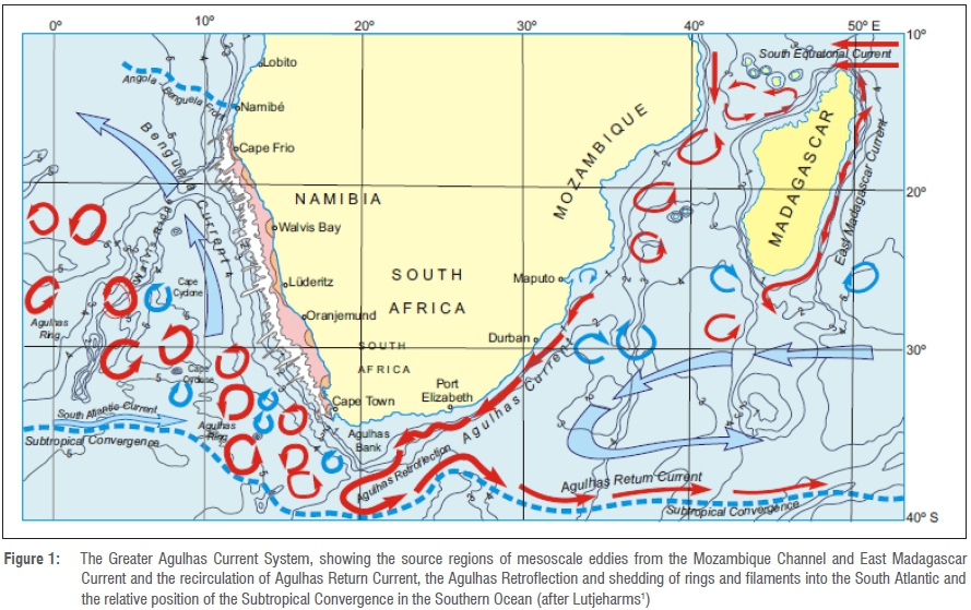
A bird's eye view of the ocean environment surrounding South Africa presents, to any oceanographer, a highly enviable snapshot of one of the most energetic ocean current systems in the world - the Greater Agulhas Current System (Figure 1).1 Lying as close as 20 km to the South African east coast, the Greater Agulhas Current System consists of three main components: the Agulhas Current, the Agulhas Return Current, and the Agulhas Leakage that forms a conduit for inter-ocean exchanges of heat and fresh water between the Indian, Atlantic and Southern Oceans. Recently, this region has become the focus of a number of international research programmes.2,3
The Agulhas Current is a well-defined western boundary current, tightly coupled to the continental slope4 with a volume transport over 75 Sv (1 Sv = 106 m3/s) and speeds exceeding 2 m/s. It originates near 26°S as a confluence of eddying flows from the Mozambique Channel and East Madagascar Current, as well as inflow from the subtropical Indian Ocean gyre.1 Beyond the southern tip of the Agulhas Bank, the Agulhas Current retroflects5-7 with most of its waters feeding back into the south Indian subtropical gyre as the Agulhas Return Current, and 10-20% leaking westward into the adjacent South Atlantic2. This leakage occurs through the generation of large warm Agulhas Rings, filaments, and sub-mesoscale processes and by a background flux component at the Agulhas Retroflection.8,9 The Agulhas Return Current extends from the Agulhas Retroflection (~20°E) as far as 75°E,10 approximately 3300 nautical miles. Its passage east remains largely zonal with meridional excursions related to meanders, some driven by bottom topography, especially in the vicinity of the Agulhas Plateau and South-West Indian Ridge.10
Surface-tracked satellite drifters, Argo floats, autonomous ocean gliders, and satellite remote sensing continue to revolutionise our ability to measure oceanic change. However, the features of the Greater Agulhas Current System are extremely energetic, narrow and deep. Satellite altimeter data are poor close to the coast, alias sub-seasonal signals,11 and cannot resolve high-velocity shears. Drifters and Argo floats are quickly flushed out of the system into more quiescent waters, and gliders are challenging to control in currents that are ten times faster than their gliding speed. Hence, there is a critical need for long-term sustained measurements from moored instrumental arrays and repeat-hydrographic observations from ships to be able to study the Greater Agulhas Current System to its full depth and resolve subsequent changes over time.
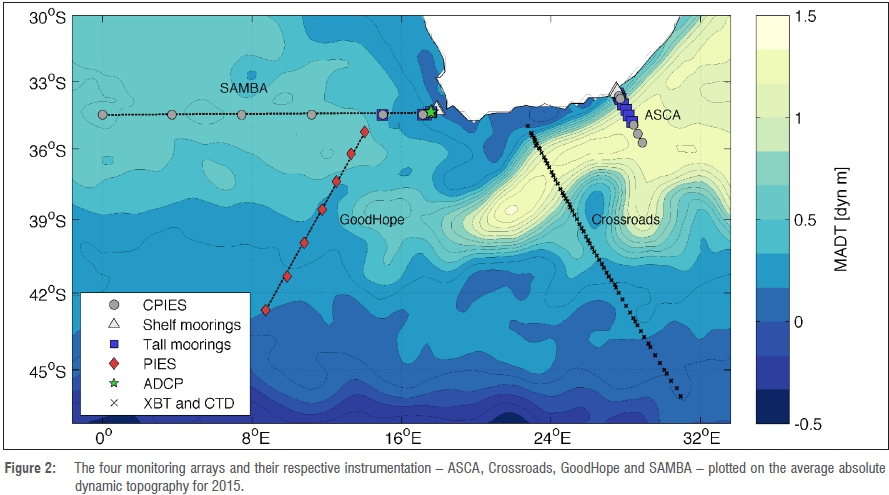
Through the South African Meridional Overturning Circulation (SAMOC-SA) and Agulhas System Climate Array (ASCA) programmes, the South African oceanographic community is taking a global leadership role in such observations, improving our understanding of the oceans around South Africa and their role in future climate change (Figure 2). These programmes are supported locally by the Department of Science and Technology (DST), the Department of Environmental Affairs (DEA), the South African Environmental Observation Network (SAEON), the South African National Antarctic Programme (SANAP), the National Research Foundation and higher education institutions including the University of Cape Town, with international partners in France (the Laboratoire d'Océanographie Physique et Spatiale (in collaboration with UBO and Ifremer, the French Agence Nationale de la Recherche, and the Ecole Normale Supérieure of Paris), the United States of America (University of Miami's Rosenstiel School of Marine and Atmospheric Sciences and the National Science Foundation) and the Netherlands (Netherlands Institute for Sea Research). Only when these arrays are fully in place and, more importantly, sustained over years to decades, can the scientific community begin to understand and predict changes in the Greater Agulhas Current System and its feedbacks on regional and global climate change, thus providing societal and economic benefits to the general public.
Opportunities
ASCA: Volume, heat and salt transports of the Agulhas Current
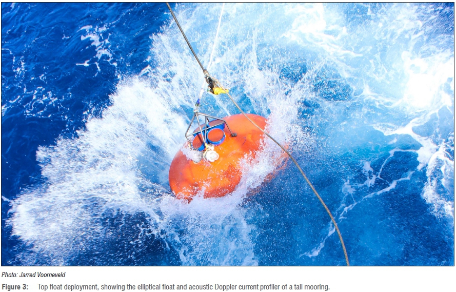
The Agulhas System Climate Array (ASCA) is a multi-institutional collaboration designed to provide the first long-term observations of Agulhas Current volume, heat and salt transport and its variability from seasonal to interannual timescales. These measurements will contribute to understanding the response of the Agulhas Current to climate change, as well as its impacts on regional and global climate variability. ASCA consists of nine full-depth moorings equipped with acoustic Doppler current profilers (ADCPs) (Figure 3), single-point current meters and microcats measuring velocity, temperature and salinity, as well as five bottom-mounted current and pressure-sensor equipped inverted echo-sounders (CPIES), measuring sound speed, pressure and bottom current velocity. Pairs of CPIES are able to estimate temperature, salinity and geostrophic velocity profiles when combined with regional Argo profiles. CPIES offshore of the tall moorings capture the Agulhas Current during offshore meanders, while those below tall moorings enhance water mass measurements over the upper water column where blowdown of the tall moorings is intense.
ASCA extends 300 km offshore along descending TOPEX/Jason satellite ground track #96 and across the core of the Agulhas Current. Six current meter moorings were initially deployed in April 2015 with a small inventory of microcats. In April 2016, these moorings were retrieved and the entire array - including an additional 52 microcats, three additional tall moorings and all five CPIES - was deployed. This work was complemented by 20 full-depth conductivity, temperature and depth casts along the ASCA line in July 2016 during a dedicated SEAmester/ASCA cruise. Other measurements collected during these cruises include vertical and oblique bongo tows, shipborne ADCP transects, surface-tracked satellite drifters, Argo float deployments and glider measurements.
A 34-month time series of moored velocity data, complemented by synoptic hydrographic and shipborne ADCP surveys, was collected along the same transect from April 2010 to February 2013 under the auspices of the US Agulhas Current Time Series Experiment (ACT),12-14 and forms the scientific basis of the ASCA project. ASCA, however, reflects an advancement over ACT, with the addition of two coastal moorings to capture shelf-slope exchanges, and microcat sensors to measure temperature and salt transport.
Results from the ACT project show the mean Eulerian current to be 219 km wide, 3000 m deep, with peak surface speeds of 1.8 m/s and a weak equatorward undercurrent at 1200 m along the continental slope.13 Using a streamwise frame of reference for their calculation, Beal et al.13 find a mean volume transport of 84±2 Sv (1 Sv = 106 m3/s), and suggest that the Agulhas Current appears stronger in the austral summer months (December-February). A sustained ASCA array over a period greater than 5 years is needed to provide a robust seasonal cycle, with interannual variability needing a data set greater than 10 years, and decadal variability and climate trends needing 20+ years.
Meander events are found to impact the Agulhas Current less than previously understood12,14,15 with events occurring less often and having only a small impact on transport. Mesoscale meanders propagate downstream and are robustly linked to eddies from the Mozambique Channel and East Madagascar Current, which impact on the Agulhas Current in its northern reaches.14 Meanders can cause the core of the Agulhas Current to weaken by ~70 cm/s and widen by ~40 km, with these two effects offsetting one another so that the southwestward volume transport of the Agulhas Current remains largely unchanged.12 At the same time, the net Eulerian transport weakens by about 20 Sv as a result of a strong inshore countercurrent during meander events.12 During meanders, coupling between the Agulhas Current and the atmosphere, together with strong upwelling, acts to cool coastal waters by over 4 °C at the surface.16 On average, only 1.6 mesoscale meanders propagate through 34°S per year,15 with two per year measured at 32°S, showing a 20% dissipation of meanders prior to reaching the Agulhas Retroflection.14,15,17 Approximately 80% of meanders are temporally consistent (within 3-6 months) with ring-shedding events into the South Atlantic Ocean, but cannot be reliably correlated because of the high eddy kinetic energies throughout the retroflection region.14 With six ring-shedding events per year and only 1.6 meanders, other influences on ring shedding must be considered.
Combining measurements from the ASCA moorings with those from the Crossroads, GoodHope and South Atlantic MOC Basin-wide Array (SAMBA) lines (discussed further below) will shed light on the links between the dynamics of the Agulhas Current and Return Current, and Agulhas Ring shedding and Leakage. Furthermore, the interplay between the Greater Agulhas Current System, regional winds, ocean sea surface temperatures, and coastal upwelling can be explored to advance understanding of their influence on South African rainfall and climate. Preliminary results suggest that ASCA captured a large meander event in 2015, which merged with the Agulhas Return Current, resulting in a suspected early retroflection of the Agulhas Current. Model studies have suggested that such an event will reduce sea surface temperatures south and west of Africa, which could, in turn, increase rainfall over the continent.
Crossroads: The Agulhas Current and its return path
Current understanding of the co-variability of the southwestward flowing Agulhas Current and the eastward Agulhas Return Current, particularly the difference in fluxes between them, remains incomplete, with knowledge largely based on remote sensing or model outputs.18 A dedicated monitoring line, critical to studying the long-term trend in the Agulhas Return Current, the nature of its warming, and its impact on local climate south of Africa, began in 2013. This transect, comprising full-depth conductivity, temperature and depth and expendable bathythermograph casts, follows directly under the altimetry track N198 and is currently in its fifth year of data acquisition.
The transect was first initiated as a seismic oceanography study in 2012, north of the Agulhas Plateau, where the Agulhas Return Current meanders around a large anticyclonic eddy. The objective of the work was to establish the origins and pathways of cold water intrusions within strong frontal regions, with results showing the interleaving of warmer, saltier south Indian subtropical waters with colder subpolar waters subducted underneath.19
An analysis of the carbonate system of the Agulhas and Agulhas Return Currents20 shows that the solubility and biological pumps play a minimal role in the drawdown of carbon from the subtropical zone (i.e. Agulhas Current); however, the solubility pump functions for CO2 drawdown within the sub-Antarctic zone. The most effective CO2 sink, using both the solubility and biological pumps, occurred within the Agulhas Plateau eddy during an initial CO2 study in 2013,20 thus providing a baseline for subsequent long-term measurements.
Given the relatively short data set (2013 to present), the Crossroads transect has already yielded interesting and useful results. The value, however, will lie in determining changes to the established baseline data, and investigating anomalies recorded. One limitation to the long-term study of fluxes and anomalies across this transect is that Crossroads is occupied once yearly on the return passage of the Marion Island Relief Voyage, thus providing only year-on-year changes and no seasonal data. Nevertheless, results from the GoodHope transect, discussed next, have shown the value of data acquired annually in helping to separate natural decadal variability from anthropogenic-induced changes in the region south of Africa.21
GoodHope: Agulhas Leakage and its influence on the region south of Africa
The GoodHope transect is an intensive oceanographic monitoring line extending from South Africa to Antarctica, initiated in 2004 and entering its 14th year in 2017. GoodHope was established to study the importance of this region as a conduit for subtropical water masses, which exchange heat and salt between the Indian, Atlantic and Southern Oceans, particularly associated with Agulhas Rings entering the sub-Antarctic zone.22 The strengths of the GoodHope line are threefold. Firstly, it follows the TOPEX/Jason altimeter track, providing ground-truth measurements for altimetry-derived sea height anomaly data. Secondly, the southern part of this line (south of 50°S) is monitored by a mooring array to investigate the formation of deep and bottom water in the Weddell Sea.23 Thirdly, the northern section of the GoodHope line is positioned to the west of the Agulhas Retroflection where it is able to capture rings and leakage transport between the Indian and Atlantic basins.24,25
Since the inception of the GoodHope project, over 25 high-resolution repeat expendable bathythermograph transects (two per year), seven full-depth hydrographic transects (five Russian, one French-International Polar Year Bonus GoodHope, and one South African in winter) have been undertaken.24 Approximately 200 Argo and Bio-Argo floats have been deployed along the GoodHope transect over these last 14 years, that together with satellite data, contribute to the understanding of basin-wide dynamics in the South Atlantic, South Indian and Southern Oceans. These data are improving our knowledge of regional mesoscale dynamics, the ventilation of intermediate water masses, and heat and saltwater exchange south of Africa.26-28 In addition, the pathways of Indian Ocean waters, advected within Agulhas Rings into the South Atlantic, have been redefined.25,27-35 These pathways are influenced by topographical features, dividing Agulhas Leakage into northern, central and southern routes. Dencausse et al.25 show that approximately 23% of Agulhas Rings advect along the southern corridor, across the subtropical front and into the sub-Antarctic zone, undergoing substantial hydrological modifications through increased mixing and high air-sea fluxes as a consequence of the cooler and fresher surroundings.25,36,37
An array of ADCPs, PIES and CPIES was deployed along the northern section of the GoodHope transect in December 2014 (Figure 2) to link the GoodHope measurements to the SAMBA (discussed further below). With SAMBA and GoodHope, Agulhas Leakage into the Atlantic Ocean via all three pathways can be monitored.
SAMBA: Investigating Agulhas Leakage and its influence on the MOC
The large meridional gap separating the southern tip of the African continent and the Agulhas Return Current, flowing along the subtropical front, is a crossroads for water mass exchange between the subtropical Indian and South Atlantic gyres. Variations in this exchange, Agulhas Leakage, have been linked to the strength and position of the westerly winds.38,39 Modelling and palaeoceaonographic studies2 suggest that the Agulhas Leakage is of critical influence on the upper limb of the MOC, with increased leakage bringing more heat and salt into the Atlantic. Observations of rising sea surface temperatures and intensifying westerly winds, together with 20th-century simulations, point to an ongoing increase in Agulhas Leakage in response to anthropogenic forcing.40,41 This increase may be strengthening the MOC42 and Atlantic Ocean heat content43, at a time when Northern Hemisphere ice melt is predicted to weaken it.2
Observing arrays are needed to monitor changes in the Atlantic MOC and improve our understanding of the influence of Agulhas Leakage on climate and climate change. The Atlantic MOC observing system consists of three arrays - two in the North Atlantic monitoring the subpolar and subtropical gyres, and one in the South Atlantic subtropical gyre between Brazil and South Africa.44 This last array, the South Atlantic MOC Basin-wide Array (SAMBA), is a collaborative initiative between South African, Brazilian, French and US oceanographers.
In September 2013, a network of eight CPIES was deployed in the ocean off Cape Town, initiating the French-South African component of SAMBA. A further eight moorings - two bottom-mounted ADCPs on the shelf edge, two more on the continental slope and four 'tall' current meter moorings extending over the deeper continental slope - were deployed in September 2014. The array currently extends from South Africa across the deep abyssal plain to 0°E.3 Additional 'tall' moorings are envisaged at the mid-Atlantic Ridge, contingent upon funding. In the meantime, repeat oceanographic surveys are planned between the African continental shelf and the Greenwich Meridian during each DST/DEA SANAP logistic voyage to Gough Island and annual or semi-annual surveys are planned for the eastern end of the SAMBA line when possible. These observing components complete the basin-wide SAMOC and will provide observations with high temporal sampling to enable estimates of Agulhas Leakage and its long-term contribution to the MOC.3
Additionally, the shelf edge and continental slope moorings will contribute knowledge to the limited understanding of the Benguela Jet, critical to fish egg and larval transport between the Agulhas Bank and west coast of South Africa.
Dynamics of the Greater Agulhas System through numerical modelling
Numerical models are a key tool for understanding in-situ observations in a broader dynamical context and there have been many studies attempting to understand the physical controls on the Agulhas Current, its leakage, and its impact on the Atlantic MOC.9,38,39,45-50
Studies linking the southern hemisphere westerlies with Agulhas Leakage demonstrate the complexities of the system, with several studies suggesting that a southward shift of the westerlies, and hence the subtropical front, results in an increase in leakage2,40,41, whereas more recent studies suggest that intensifying westerlies relate to an increase in leakage38,51. It has been further suggested that the leakage is both inversely proportional to Agulhas Current transport52 and proportional to Agulhas Current transport41 and that it is decoupled from its transport39. Only observations such as ASCA and SAMBA can determine in what dynamical regime the Agulhas system currently resides.
More recently, climate models and ocean reanalysis products have been used to show that subtropical western boundary currents, including the Agulhas Current, may be intensifying and shifting polewards as a result of the long-term effects of global warming. However, these currents are not yet resolved in state-of-the-art climate models, such as those used by the Intergovernmental Panel on Climate Change. Low resolution, lack of ocean measurements, and uncertainties in wind products make these results irresolute.53 Again, in-situ observations of the real ocean are vital to constrain models and to give a true understanding of oceanic change around South Africa, bringing us full circle to the importance of the SAMOC-SA and ASCA programmes.
Within the South African marine science community, proficiency has been developed with numerical model based coastal and regional oceanographic studies. Coupled with this is the growth of skilled users of satellite-derived marine data and products and algorithm development. It is essential that the standards of physical observational science are maintained at the same skilled level, to enhance our understanding of the Greater Agulhas Current System using all the tools available to us.
A call for sustained observations
South Africa is uniquely positioned globally, between three diverse oceans linked together by the Greater Agulhas Current System and its leakage. Despite the significance of the Agulhas Current regionally and globally, the state of observations and modelling of the oceans south of Africa is not as developed as that of other regions, such as the North Atlantic (Gulf Stream) and North Pacific (Kuroshio Current) western boundary current systems. This underdevelopment can be linked to limited ship availability and on-board equipment, insufficient resources, scarcity of qualified and employed seagoing technical and scientific personnel, and lack of technological innovation for buoys and sensor prototypes suitable for the uniquely energetic conditions of the Agulhas.
Large, natural variability within dynamic western boundary currents, such as the Greater Agulhas Current, obscure longer-term signals such as climate change. Only through sustained in-situ measurements can these signals be untangled. Currently, we have an incomplete picture of the mean state and variability of our sector and surrounds, of its coupling with the atmosphere, and of the exchange between the zonal and meridional fluxes across neighbouring basins. Our observations are limited in space and time and our models do not confidently simulate the complex processes within the Greater Agulhas Current System. For instance, recent observations have shown that the annual cycle of the Agulhas Current is not captured realistically by simulations.54
The SAMOC-SA and ASCA projects have begun to fill in these gaps and have the potential to place South Africa as a leader in the international oceanographic research. However, these observations will need to be sustained over decades to fulfil their true potential as 'fingers on the pulse' of South Africa's oceans and their influence on regional and global climates. These observing systems are the key to quantification, physical understanding and long-term monitoring of the Greater Agulhas Current System as the connection between the Indian, Atlantic and Southern Oceans, and to understanding the importance of our oceans as a potential driver of climate change. Furthermore, SAMOC-SA and ASCA are providing a platform for international collaborations and capacity building which, if sustained, will help train the next generation of South African oceanographers and technicians. For example, in a recent initiative, the SEAmester Floating University programme partnered with ASCA to train students aboard the MV SA Agulhas II.55 Most importantly, these arrays place South Africa at the heart of the international community's Global Ocean Observing System (GOOS), to become a major contributor to future understanding and predictions of climate change.
One of the greatest challenges for researchers in South Africa is the need for strategic organisational integration and cooperation across relevant governmental departments, so that the ambitions of these large mooring arrays can be realised. Both the ASCA and SAMOC-SA programmes are funded in South Africa primarily through DST, with reliance on DEA for ship time, equipment and technical support. The successful operation of these programmes would additionally benefit from efficient consultation, communication and collaboration at the management levels of these government departments. Researchers struggle to understand the complexities of management level procedures needed to raise funds and would benefit from support in this regard. Although it is recognised that there are many unique South African socio-economic challenges (health, poverty, safety, etc.) that compete towards the shrinking fiscus, it is important to recognise that the results emanating from this research provide science-based management advice including information products towards mitigating against natural seaborne disasters. A great effort is thus required to demonstrate the importance and benefits of these observation arrays to the general public in a bid to get full support of management from the government departments currently involved, and where possible, obtain the endorsement from government departments which could benefit from the work, such as the Departments of Agriculture, Forestry and Fisheries, of Energy and of Mineral Resources. Different funding streams must be sought and matched with priority areas to achieve the basic scientific operations on which currently funded research relies, thus demonstrating the usefulness of the results achieved thus far. What is needed are clear and well-structured agreements (MoAs, MoUs and contracts) between the departments and various agencies, characterising the respective commitments and responsibilities to these large programmes as regards personnel, instrumentation, ship time, data processing and management, and the costs thereof.
There are other significant challenges in sustaining these important observational systems for South Africa and for GOOS. Obtaining commitments to the necessary long-term funding is problematic, given the constraint of three-year government funding cycles. The scientific equipment aboard South African research vessels must be more regularly calibrated and better configured in order to attain international standards. To be a partner in GOOS, and to detect the small yet important signals of oceanic variability and change, precision and accuracy are paramount. Finally, technical and scientific staff need to be given long-term roles, responsibilities and dedicated time in these programmes so that they can leverage available international training and collaboration towards building future autonomous capacity for South Africa, thus benefiting South Africa's societal needs. Overcommitment of current technical staff and lack of career opportunities within marine research leads to lack of retention of knowledge and skills for the relevant institutions and organisations and jeopardises the future of these ambitious programmes.
The DST has identified the understanding of ocean dynamics as a key research theme in its 10-year Global Change Research Plan for South Africa. Furthermore, the South African government's National Development Plan and the objectives behind Operation Phakisa (Oceans Economy) identify these very real issues at the heart of South Africa's success in achieving its long-term development goals in the marine sciences and its sustained growth within South Africa and beyond. There is no lack of acknowledgement of the importance and priority at a high level, so the challenge lies in realising this into substantial commitments in terms of funding and institutional cooperation.
The various programmes highlighted in this article have already demonstrated great success in their contributions towards putting in place infrastructure, and more importantly towards training and developing skills and capacity. These programmes have established scientific baselines as well as some initial understanding of the dynamics of the oceans around South Africa. The next level of engagement and commitment, which has been inadequate in previous programmes, is to convert the data and information emanating from such initiatives into knowledge products that are readily available to the general public of South Africa, and the region, thus giving the programmes even more prominence and in turn attracting new and continued funding from private and public entities. With formal integration and cooperation of all partners involved, the work can be amplified significantly and make South African marine science a force to be reckoned with.
Acknowledgements
We acknowledge the continued support of the Department of Science and Technology and the National Research Foundation of South Africa through its South African National Antarctic Programme and South African Environmental Observation Network (SAEON), and the Department of Environmental Affairs (DEA, Branch: Oceans and Coasts). Furthermore, we acknowledge the support of international partners to the SAMOC-SA project: the French institutions Ifremer, Agence Nationale de la Recherche (ANR; project ANR-11-IS56-0004), the European University Institute for the Sea (IUEM), the Coriolis and Euro-Argo data centers and the European AtlantOS H2020 Project with the European Union's Horizon 2020 research and innovation programme under grant agreement no. 633211 (AtlantOS), in particular to the GoodHope and SAMBA arrays, and to the ASCA project: The Royal Netherlands Institute of Sea Research (NIOZ) and University of Miami (RSMAS). ASCA is supported by a National Science Foundation grant #OCE-0850891. We thank the invaluable technical and support teams from DEA, SAEON, University of Cape Town, Ifremer, École Normalae Supérieure, NIOZ and RSMAS that have made all the respective cruises successful. We also thank Beate Holscher for valuable contributions to the manuscript and the anonymous reviewers for their helpful comments during the review process. Finally, we thank the Captains, officers and crew of the RV Algoa and the MV SA Agulhas II for their outstanding support.
Authors' contributions
Funding for mooring/monitoring arrays was sourced by J.H., L.B., S.S., I.J.A. and M.R.; the manuscript was written by T. M., J.H., L.B. and I.J.A. and edited by M.d.P., C.D.R., M.G., T.L., M.R. and S.S.; Figure 2 was constructed by M.d.P.
References
1. Lutjeharms JRE. The Agulhas Current. In: Steele J, Thorpe S, Turekian K, editors. Encyclopedia of ocean science. London: Academic Press, 2001; p. 104-113. https://doi.org/10.1016/B978-012374473-9.00365-9 [ Links ]
2. Beal LM, De Ruijter WPM, Biastoch A, Zahn R, SCOR/WCRP/IAPSO Working group 136. On the role of the Agulhas system in ocean circulation and climate. Nature. 2011;472:429-436. https://doi.org/10.1038/nature09983 [ Links ]
3. Ansorge IJ, Baringer M, Campos EJD, Dong S, Fine RA, Garzoli SL, et al. Basin-wide oceanographic array bridges the South Atlantic. Eos Trans AGU. 2014;95(6):53-54. https://doi.org/10.1002/2014EO060001 [ Links ]
4. De Ruijter WPM, Van Leeuwen PJ, Lutjeharms JRE. Generation and evolution of Natal Pulses: Solitary meanders in the Agulhas Current. J Phys Oceanogr. 1999;29(12):3043-3055. https://doi.org/10.1175/1520-0485(1999)029<3043:GAEONP>2.0.CO;2 [ Links ]
5. Gordon AL. Indian-Atlantic transfer of thermocline water at the Agulhas retroflection. Science. 1985;227(4690):1030-1033. https://doi.org/10.1126/science.227.4690.1030 [ Links ]
6. Gordon AL, Lutjeharms JRE, Gründlingh ML. Stratification and circulation at the Agulhas Retroflection. Deep-Sea Res. 1987;34(4):565-599. https://doi.org/10.1016/0198-0149(87)90006-9 [ Links ]
7. Lutjeharms JRE, Van Ballegooyen RC. The retroflection of the Agulhas Current. J Phys Oceanogr. 1988;18(11):1570-1583. [ Links ]
8. Van Ballegooyen RC, Gründlingh ML, Lutjeharms JRE. Eddy fluxes of heat and salt from the southwest Indian Ocean into the southeast Atlantic Ocean: A case study. J Geophys Res. 1994;99(C7):14053-14070. https://doi.org/10.1029/94JC00383 [ Links ]
9. Holton L, Deshayes J, Backeberg BC, Loveday BR, Hermes JC, Reason CJC. Spatio-temporal characteristics of Agulhas Leakage: A model inter-comparison study. Clim Dyn. 2017;48(7-8):2107-2121 https://doi.org/10.1007/s00382-016-3193-5 [ Links ]
10. Lutjeharms JRE, Ansorge I. The Agulhas Return Current. J Marine Syst. 2001;30(1/2):115-138. https://doi.org/10.1016/S0924-7963(01)00041-0 [ Links ]
11. Byrne DA, McClean JL. Sea level anomaly signals in the Agulhas Current region. Geophys Res Lett. 2008;35, L13601, 5 pages. https://doi.org/10.1029/2008GL034087 [ Links ]
12. Leber GM, Beal LM. Evidence that Agulhas Current transport is maintained during a meander. J Geophys Res. 2014;119:3806-3817. https://doi.org/10.1002/2014JC009802 [ Links ]
13. Beal LM, Elipot S, Houk A, Leber GM. Capturing the transport variability of a western boundary jet: Results from the Agulhas Current Time-Series Experiment (ACT). J Phys Oceanogr. 2015;45:1302-1324. https://doi.org/10.1175/JPO-D-14-0119.1 [ Links ]
14. Elipot S, Beal LM. Characteristics, energetics, and origins of Agulhas Current meanders and their limited influence on ring shedding. J Phys Oceanogr. 2015;45:2294-2314. http://dx.doi.org/10.1175/JPO-D-14-0254.1 [ Links ]
15. Rouault MJ, Penven P. New perspectives on Natal Pulses from satellite observations. J Geophys Res. 2011;116, C07013, 14 pages. https://doi.org/10.1029/2010JC006866 [ Links ]
16. Leber GM, Beal LM, Elipot S. Wind and current forcing combine to drive strong upwelling in the Agulhas Current. J Phys Oceanogr. 2017;47:123-134. https://doi.org/10.1175/JPO-D-16-0079.1 [ Links ]
17. Krug M, Tournadre J. Satellite observations of an annual cycle in the Agulhas Current. Geophys Res Lett. 2012;39, L15607, 6 pages. http://dx.doi.org/10.1029/2012GL052335 [ Links ]
18. Rouault MJ, Mouche A, Collard F, Johannessen JA, Chapron B. Mapping the Agulhas Current from space: An assessment of ASAR surface current velocities. J Geophys Res-Oceans. 2010;115(C10), C10026, 14 pages. https://doi.org/10.1029/2009JC006050 [ Links ]
19. Book JW, Wood WT, Rice AE, Carniel S, Hobbs RW, Ansorge I, et al. Seismic oceanography imaging of thermal intrusions in strong frontal regions. Proc Mtgs Acoust. 2013;19, 005010, 5 pages. https://doi.org/10.1121/1.4799118 [ Links ]
20. Melato LI. Characterization of the carbonate system across the Agulhas and Agulhas Return Currents [MSc thesis]. Cape Town: University of Cape Town; 2014. [ Links ]
21. Swart S, Speich S, Ansorge IJ, Goni GJ, Gladyshev S, Lutjeharms JRE. Transport and variability of the Antarctic Circumpolar Current south of Africa. J Geophys Res. 2008;113, C09014, 24 pages. https://doi.org/10.1029/2007JC004223 [ Links ]
22. Ansorge I, Lutjeharms JRE. Direct observations of eddy turbulence at a ridge in the Southern Ocean. Geophys Res Lett. 2005;32, L14603, 4 pages. https://doi.org/10.1029/2005GL022588 [ Links ]
23. Gordon AL, Huber B, McKee D, Visbeck M. A seasonal cycle in the export of bottom water from the Weddell Sea. Nature Geosci. 2010;3:551-556. https://doi.org/10.1038/ngeo916 [ Links ]
24. Speich S, Arhan M, Rusciano E, Faure V, Ollitrault M, Prigent A. Use of ARGO floats to study the ocean dynamics south of Africa: What we have learned from the GoodHope project and what we plan within the SAMOC International Programme. Mercator Ocean-Coriolis Quarterly Newsletter #45. 2012 April; pages 21-27. Available from: http://archimer.ifremer.fr/doc/00114/22553/20241.pdf [ Links ]
25. Dencausse G, Arhan M, Speich S. Routes of Agulhas Rings in the southeastern Cape Basin. Deep-Sea Res Pt I. 2010;57(11):1406-1421. https://doi.org/10.1016/j.dsr.2010.07.008 [ Links ]
26. Swart S, Speich S. An altimetry-based gravest empirical mode south of Africa: 2. Dynamic nature of the Antarctic Circumpolar Current fronts. J Geophys Res-Oceans. 2010;115, C03003, 22 pages. https://doi.org/10.1029/2009JC005300 [ Links ]
27. Legeais JF, Speich S, Arhan M, Ansorge I, Fahrbach E, Garzoli S, et al. The baroclinic transport of the Antarctic Circumpolar Current south of Africa. Geophys Res Lett. 2005;32, L24602, 5 pages. https://doi.org/10.1029/2005GL023271 [ Links ]
28. Swart S, Speich S, Ansorge IJ, Lutjeharms JRE. An altimetry-based gravest empirical mode south of Africa: 1. Development and validation. J Geophys Res-Oceans. 2010;115, C03002, 19 pages. https://doi.org/10.1029/2009JC005299 [ Links ]
29. Speich S, Lutjeharms JRE, Penven P, Blanke B. Role of bathymetry in Agulhas Current configuration and behaviour. Geophys Res Lett. 2006;33, L23611, 5 pages. https://doi.org/10.1029/2006GL027157 [ Links ]
30. Speich S, Blanke B, Cai W. Atlantic meridional overturning circulation and the Southern Hemisphere supergyre. Geophys Res Lett. 2007;34, L23614, 5 pages. https://doi.org/10.1029/2007GL031583 [ Links ]
31. Speich S, Arhan M. ARGO floats sample vertically homogeneized water in Agulhas Rings. Coriolis Newsletter. 2007 volume 4; pages 15-16. [ Links ]
32. Doglioli AM, Veneziani M, Blanke B, Speich S, Griffa A. A Lagrangian analysis of the Indian-Atlantic interocean exchange in a regional model. Geophys Res Lett. 2006;33(14):48-52. https://doi.org/10.1029/2006GL026498 [ Links ]
33. Doglioli AM, Blanke B, Speich S, Lapeyre G. Tracking coherent structures in a regional ocean model with wavelet analysis: Application to Cape Basin eddies. J Geophys Res. 2007;112, C05043, 12 pages. https://doi.org/10.1029/2006JC003952 [ Links ]
34. Dencausse G, Arhan M, Speich S. Spatio-temporal characteristics of the Agulhas Current retroflection. Deep-Sea Res Pt I. 2010;57(11):1392-1405. https://doi.org/10.1016/j.dsr.2010.07.004 [ Links ]
35. Dencausse G, Arhan M, Speich S. Is there a continuous Subtropical Front south of Africa? J Geophys Res-Oceans. 2011;116, C02027, 14 pages. https://doi.org/10.1029/2010JC006587 [ Links ]
36. Backeberg BC, Penven P, Rouault M. Impact of intensified Indian Ocean winds on mesoscale variability in the Agulhas system. Nat Clim Change. 2012;2:608-612. https://doi.org/10.1038/nclimate1587 [ Links ]
37. Gladyshev S, Arhan M, Sokov A, Speich S. A hydrographic section from South Africa to the southern limit of the Antarctic Circumpolar Current at the Greenwich meridian. Deep-Sea Res Pt I. 2008;55(10):1284-1303. https://doi.org/10.1016/j.dsr.2008.05.009 [ Links ]
38. Durgadoo JV, Loveday BR, Reason CJC, Penven P, Biastoch A. Agulhas Leakage predominantly responds to the Southern Hemisphere westerlies. J Phys Oceanogr. 2013;43:2113-2131. https://doi.org/10.1175/JPO-D-13-047.1 [ Links ]
39. Loveday BR, Durgadoo JV, Reason CJC, Biastoch A, Penven P. Decoupling of the Agulhas Leakage from the Agulhas Current. J Phys Oceanogr. 2014;44:1776-1797. http://dx.doi.org/10.1175/JPO-D-13-093.1 [ Links ]
40. Biastoch A, Böning CW, Schwarzkopf FU, Lutjeharms JRE. Increase in Agulhas Leakage due to poleward shift of Southern Hemisphere westerlies. Nature. 2009;462:495-498. http://dx.doi.org/10.1038/nature08519. [ Links ]
41. Rouault M, Penven P, Pohl B. Warming of the Agulhas Current since the 1980s. Geophys Res Lett. 2009;36, L12602, 5 pages. https://doi.org/10.1029/2009GL037987 [ Links ]
42. Biastoch A, Böning CW. Anthropogenic impact on Agulhas Leakage. Geophys Res Lett. 2013;40:1138-1143. https://doi.org/10.1002/grl.50243 [ Links ]
43. Lee SK, Park W, Van Sebille E, Baringer MO, Wang C, Enfield DB, et al. What caused the significant increase in Atlantic Ocean heat content since the mid-20th century? Geophys Res Lett. 2011;38, L17607, 10 pages. https://doi.org/10.1029/2011GL048856 [ Links ]
44. Schiermeier Q. Oceans under surveillance. Nature. 2013;497:167-168. https://doi.org/10.1038/497167a [ Links ]
45. Veitch J, Penven P, Shillington FA. Modeling equilibrium dynamics of the Benguela Current System. J Phys Oceanogr. 2010;40:1942-1964. https://doi.org/10.1175/2010JPO4382.1 [ Links ]
46. Veitch J, Penven P, Shillington FA. The Benguela: A laboratory for comparative modeling studies. Progr Oceanogr. 2009;83,1-4:206-302. https://doi.org/10.1016/j.pocean.2009.07.008 [ Links ]
47. Biastoch A, Krauss W. The role of mesoscale eddies in the source regions of the Agulhas Current. J Phys Oceanogr. 1999;29:2303-2317. http://dx.doi.org/10.1175/1520-0485(1999)029<2303:TROMEI>2.0.CO;2 [ Links ]
48. Blanke B, Penven P, Roy C, Chang N, Kokoszka F. Ocean variability over the Agulhas Bank and its dynamical connection with the southern Benguela Upwelling System. J Geophys Res Oceans. 2009;114, C12028, 15 pages. https://doi.org/10.1029/2009JC005358 [ Links ]
49. Backeberg BC, Bertino L, Johannessen JA. Evaluating two numerical advection schemes in HYCOM for eddy-resolving modelling of the Agulhas Current. Ocean Sci. 2009;5:173-190. https://doi.org/10.5194/os-5-173-2009 [ Links ]
50. Penven P, Lutjeharms JRE, Florenchie P. Madagascar: A pacemaker for the Agulhas Current System? Geophys Res Lett. 2006;33, L17609, 5 pages. https://doi.org/10.1029/2006GL026854 [ Links ]
51. Le Bars D, De Ruijter WPM, Dijkstra HA. A new regime of the Agulhas Retroflection: Turbulent choking of Indian-Atlantic leakage. J Phys Oceanogr. 2012;42:1158-1172. https://doi.org/10.1175/JPO-D-11-0119.1 [ Links ]
52. Van Sebille E, Biastoch A, Van Leeuwen PJ, De Ruijter WPM. A weaker Agulhas Current leads to more Agulhas Leakage. Geophys Res Lett. 2009;36, L03601, 4 pages. https://doi.org/10.1029/2008GL036614 [ Links ]
53. Yang H, Lohmann G, Wei W, Dima M, Ionita M, Liu J. Intensification and poleward shift of subtropical western boundary currents in a warming climate. J Geophys Res Oceans. 2016;121:4928-4945. https://doi.org/10.1002/2015JC011513 [ Links ]
54. Beal LM, Elipot S. Broadening not strengthening of the Agulhas Current since the early 1990s. Nature. 2016;540:570-573. https://doi.org/10.1038/nature19853 [ Links ]
55. Ansorge IJ, Brundrit G, Brundrit J, Dorrington R, Fawcett S, Gammon D, et al. SEAmester - South Africa's first class afloat. S Afr J Sci. 2016;112(9-10), Art. #a0171, 4 pages. https://doi.org/10.17159/sajs.2016/a0171. [ Links ]
 Correspondence:
Tamaryn Morris
Email: tammy@saeon.ac.za
Received: 31 Oct. 2016
Revised: 07 Feb. 2017
Accepted: 07 Apr. 2017
FUNDING: South African Department of Environmental Affairs; South African Department of Science and Technology; National Research Foundation (South Africa); Laboratoire d'Océanographie Physique et Spatiale (France); the French Agence Nationale de la Recherche; the Ecole Normale Supérieure of Paris; the University of Miami's Rosenstiel School of Marine and Atmospheric Sciences; National Science Foundation (USA); Netherlands Institute for Sea Research (NIOZ)

