


Serviços Personalizados
Artigo
 Inglês (pdf)
 Artigo em XML
 Referências do artigo
Indicadores

Links relacionados
-
 Citado por Google
 -
 Similares em Google
Compartilhar

 Permalink
South African Journal of Science
versão On-line ISSN 1996-7489
versão impressa ISSN 0038-2353
S. Afr. j. sci. vol.112 no.1-2 Pretoria Jan./Fev. 2016
http://dx.doi.org/10.17159/sajs.2016/20150025
RESEARCH ARTICLE
Evidence for aeolian origins of heuweltjies from buried gravel layers
Michael D. CramerI; Johanna von HoldtII; Lesego KhomoI; Jeremy J. MidgleyI
IDepartment of Biological Sciences, University of Cape Town, Cape Town, South Africa
IIDepartment of Environmental and Geographical Science, University of Cape Town, Cape Town, South Africa
ABSTRACT
Although heuweltjies (19-32 m diameter) dominate the surface of much of the southwestern Cape of South Africa, their origins, distribution and age remain controversial. Current hypotheses are that the heuweltjies are (1) constructed by the excavation and mounding habits of burrowing animals; (2) the result of erosion by water of areas between patches protected from fluvial action by denser vegetation or (3) the product of localised aeolian sediment accumulation beneath denser vegetation associated with termitaria. At a site where quartz-containing gravels occur on the soil surface in areas between heuweltjies, these gravels were found to extend as a relatively intact layer of uniform concentration from the inter-mound area into the mound at the same plane as the surrounding soil surface. This buried layer suggests that heuweltjies were either built-up by deposition on a previous soil surface layer or eroded from sediment accumulated above the buried gravel layer. Mounds contain a relatively large proportion of silt consistent with sediment deposition. Mound sediment elemental composition was strongly correlated with that of local shale, indicating a local source of sediment. Pedogenesis was considerably more advanced off- than on-mound. There was no evidence of extensive regional aeolian sediment mantling over the vast area in which the heuweltjies occur. These findings and observations support the aeolian deposition hypothesis of heuweltjie origins combined with a degree of erosion, rather than a termite bioturbation hypothesis or a predominantly erosion-based hypothesis.
Keywords: mima-mounds; termite; erosion; vegetation pattern; calcrete
Introduction
To date three classes of hypotheses have been invoked to explain the regular (i.e. over-dispersed) patterning and the raised circular forms of heuweltjies, mounds of about 20 m in diameter that occupy 1.2% of the southwestern Cape landscape.1 The bioturbation hypothesis suggested that they were constructed by earth-moving activities of fossorial mammals and/or termites,2-4 although the role of mammals has largely been considered to be secondary to termites.4 Inter-mound distances are considered to be within a range that competing aggressive termites may realistically space themselves.4 Cramer et al.5 argued that mounds are far too large to have been made by any known termite. Instead of heuweltjies being constructional features, they argued that erosion by water of areas not protected by regularly spaced vegetation clumps is the mechanism responsible for the mounds and their spacing, similar to mounds in Brazil.6 McAuliffe et al.7 rejected this erosion hypothesis and suggested an aeolian accretion hypothesis in which aeolian sediment has accumulated around regularly spaced loci, similar to the formation of coppice dunes (also known as nebkhas or nabkhas).8 McAuliffe et al.7 argued that harvester termite mounds initiated the regular vegetation patterning by providing nutrient-rich soil loci for plants. Termites are also thought to have provided a local accumulation of calcium oxalate-rich plant biomass, which has facilitated the development of the calcified layer characteristic of many heuweltjies.2,4,7-11
McAuliffe et al.7 studied heuweltjies on the low-relief plain near the west coast of South Africa with widespread aeolian sand deposits. This voluminous sand supply was implicated as the sediment source for the rather large (about 30 m diameter, 2 m height) heuweltjies that commonly occur in that area. These authors used the greater degree of pedological development of off-mound soils to argue for aeolian deposition of sediments on mounds than intervening areas. Despite some differences in on- and off-mound sediment particle sizes, 7the particle size distributions are broadly similar,3 suggesting that the sediments on- and off-mounds were originally derived from the same source.
In addition to textural differences between on- and off-mound soils, there are also chemical differences that relate to the process that lead to mound formation. It has been commonly observed that heuweltjies have petrocalcic (i.e. calcrete) horizons that are absent in the off-mound areas.11 McAuliffe et al.7 concluded that the variability in the development of petrocalcic horizons may be associated with the age of the mounds, with older heuweltjies forming more extensive petrocalcic horizons. Heuweltjie calcretes are ancient11 and the source of their Ca is contentious. McAuliffe et al.7 and others have suggested that source of the Ca was the termites Microhodotermes viator, that have been proposed to partially forage off-mound and deposit Ca-rich frass on-mound.7,11,12 Heuweltjie soils also contain higher concentrations of N, P K, B, Cu, Fe, Mn and Zn,13,14 and bioaccumulation by termites has also been invoked to explain the accumulation of these other nutrients.7 Based on 87Sr/86Sr ratios of calcrete that are distinct from underlying rocks, it has, however, been suggested that the source is of marine origin delivered via atmospheric transport.12 Finally, Ca accumulation on-mound was also suggested to be the consequence of plant nutrient mass-flow concentrating nutrients around plant roots,5 analogous to the formation of caliche associated with 'islands of fertility'.15,16 Clearly, the formation of heuweltjies and associated calcrete and nutrient-rich soils continues to be contentious.
Identifying previous soil surface levels would provide a test of all three hypotheses above. The aeolian deposition hypothesis would predict that surface gravels, indicative of the level of a previous soil surface within a mound, should largely be on the same level as those off-mound. This would indicate that the mound has been constructed on top of a previous soil surface. In contrast, the bioturbation hypothesis suggests that termites capable of moving particles less than 1 mm in diameter17 would cause coarse surface gravels in mounds to sink below those in the off-mound soil.1 This would occur as termites gradually excavate their subterranean tunnels and storage sites and as they carry finer soil particles upwards to construct their indurate mounds. Some of these gravels may later be returned to the surface through mammalian bioturbation, for instance by moles, porcupines and aardvarks. If prior to mound formation the land surface contained distributed gravel, the erosion hypothesis would predict that surface gravel off-mound would be lower than that within the mound, as off-mound erosion would cause them to sink relative to those protected from erosion within the mound.
We selected a study site in the southwestern Cape in South Africa at which a continuous gravel layer exists in the off-mound surface layer. Relative to the age of heuweltjies, this layer may be ancient, as evidenced by associated endemic dwarf succulent plant species and specific plant communities.18 Also, this layer was found within heuweltjies indicating it predates the formation of heuweltjies (This gravel layer will be discussed later in the article). We used this gravel layer to test the above three hypotheses, and also used particle size and elemental analysis to provide additional information to substantiate our conclusion that vegetation accelerated aeolian deposition likely accounts for mound formation.
Methods and Materials
Study site
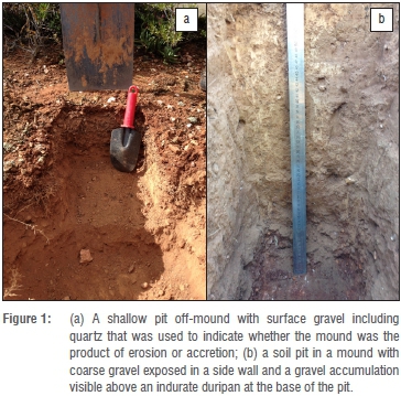
We sampled mounds near Worcester (33° 37.416S, 19° 32.226E) in vegetation identified as Robertson Karoo. This site is underlain by Bokkeveld Group metasediments, including shale and quartz veins. The heuweltjies that were sampled are situated on the concave lower slopes of a hill (240 m above study site). The site has a mean annual temperature of 16.7 °C and 455 mm annual precipitation, 205 mm of which falls in the coldest quarter and 43 mm in the warmest quarter (http://www.worldclim.org/bioclim). The vegetation of the region is low stature (<2 m) and shrubby with many succulents occurring on the mounds. The mound boundaries were readily identifiable by the change in vegetation, with important on-mound genera being Aloe, Euphorbia, Cotyledon, Tylecodon, Searsia and Euclea. The study site was selected because it has gravel on the inter-mound surface (Figure 1a). This gravel layer consists predominantly of quartz, but shale fragments are also present. Quartz veins are evident in the landscape immediately upslope of the heuweltjies. Although some heuweltjies at the locale contain well-developed layers of calcrete within them, several of the mounds examined in this investigation lacked such layers (Figure 1b).
Mound survey
Seven mounds were selected on terrain with a moderate slope (<10%). For each mound, the perimeter of the mound was defined on the basis of the change in elevation and vegetation characteristics. The down-slope
and across-slope directions were determined and then a Leica NA720 Automatic Level (Leica Geosystems, Johannesburg, South Africa) was used to measure the elevation of the mounds at about 1 m intervals starting from 2 m into the off-mound area downslope and continuing across the mound to 2 m off-mound upslope. The measurements were used to calculate the maximum height of the mound above a linear interpolation between the off-mound points in two orthogonal directions, and these heights were averaged. This allowed estimation of the depth the gravel layer would be expected within the mound. The mound diameter was used to estimate the mound area for the approximately circular mounds. The mound volume was estimated from the area and the average heights of the mounds in the two measured orthogonal directions.
Gravel, soil and rock sampling
Sampling was carried out from the surface off- and on-mound to the depth of a hard, gravelly duripan. In the case of the biggest mound, this duripan coincided with a strongly cemented petrocalcic horizon. Initial sampling (n=7) of mounds was conducted using a 0.07 m diameter auger allowing sampling in 0.22 m increments and ready identification of the location of the gravel layer. Considering the difficulty of getting the auger through the duripan horizons below the gravel layer, we also excavated pits in a subset of mounds (n=5). In addition to these mounds, one of the largest mounds in the area was also excavated. For pits, the soil area was marked out in a 0.2 m x 0.2 m area and excavated in 0.2 m intervals. Off-mound sampling was restricted to a single 0-0.2 m depth, but on-mound sampling was to a maximum depth of 0.8 m, apart from the large mound that was sampled to a depth of 1.8 m. The soil excavated by auger or from each 0.2 m x 0.2 m x 0.2 m volume was sieved through a 0.005 m mesh sieve. Care was taken to break up peds so that only coarse gravel remained on the sieve. The coarse gravel and sieved soil were transported to the laboratory and the stones were weighed. The sieved stones were subject to size fractionation using a test sieve shaker (Endecott Ltd, London, UK) and then each fraction was weighed. We were able to get a larger and more representative sample from the pits than from using the auger, so we based measures of gravel concentration, particle size and pH on samples from the pits. The 5 mm sieved soil was air-dried for 48 h and then 1 mm sieved samples were split by repeatedly quartering the soil and taking opposite quarters for each successive sub-sample to provide samples of appropriate volume19 for particle size analysis and elemental analysis. Samples of shale and quartz from rock outcrops were collected, the surface cleaned with a steel brush followed by washing with a domestic power washer before being crushed.
Soil particle size analysis
Soil particle size distributions were analysed using a Malvern Mastersizer 2000 (Malvern Instruments Ltd, Malvern, UK) on sieved soils smaller than 1 mm suspended in water and ultrasonically dispersed, stirred and introduced to the laser diffractometer with a Malvern Hydro 2000G wet dispersion unit. The organic material that floated to the surface was removed by hand. Each sample was subjected to 180 s ultrasonic dispersal to ensure complete disaggregation of particles. The proportion of the soil particles in each size class were recorded and plotted. These size classes were then summed into categories representing clay, silt and sand, according to the Wentworth grain size chart.20
Soil and rock elemental and pH analysis
Sieved (<1 mm) soil and crushed rock samples were milled to a fine powder with a mortar and pestle. The powder was placed in sample cups with a polypropylene bottom and analysed in a Spectroscout energy-dispersive X-ray Fluorescence (XRF) analyser (SPECTRO Analytical Instruments, Kleve, Germany). The duration of sampling for each filter was set to 100 s for each of the Pd, Mo and Ta filters and 100 s without a filter. The instrument was calibrated by using a certified standard GBW07312 (National Research Center for CRMs, Beijing, China), for which elemental concentrations were obtained from NOAA Technical memorandum NOS ORCA 68 (1992). The elements measured (all above detection limit in all samples) were Na, Mg, Al, P K, Ca, Ti, V, Cr, Mn, Fe, Ni, Cu, Zn, Ga, As, Se, Br, Rb, Sr, Y, Zr, Ba, W, Hg, Tl, Pb, Bi and Th. Soil pH was measured by suspending about 20 g sieved air-dried soil in 50 mL 1 M KCl, stirring with a glass rod, allowing to settle for 1 h and then immersing a pH electrode in the supernatant.
Mound profile descriptions
Profile descriptions were made in two on- and one off-mound position. Major horizons were identified, measured and sampled (multiple samples were taken in thick horizons). The profiles were excavated to the depth of the impenetrable duripan for one mound and the nearby off-mound sites. For one larger mound, sampling was carried out to a depth of 1.8 m, where a nodular calcrete layer prevented further excavation. Sampling to this depth was only possible because of prior excavation by an aardvark, which had dug through an indurated layer, which appeared to be a combination of duripan and calcrete. These samples were analysed for particle size and XRF elemental analysis was conducted as described above. The presence of carbonates was also confirmed by testing the effervescence with the addition of a 10% (v/v) HCl solution. Soil horizon characteristics were described following guidelines for soil description (FAO).21
Statistical analyses
Soil gravel concentration, soil pH and elemental concentrations were analysed using ANOVA with post-hoc Tukey tests and general linear models in R22 to determine whether there were significant (p<0.05) differences between the values. Linear regression and confidence intervals were calculated using ggplot2 in R.
Results
Mound morphology and profiles
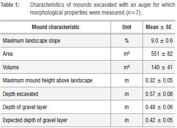
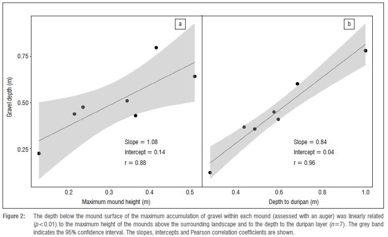
The surveyed mounds had small volumes relative to other mounds in the region (c.f. Cramer et al.5) and an average height of only 0.32 m above the landscape surface (Table 1), apart from the one larger mound sampled, which had a height of 1.1 m. Nevertheless, the mounds were clearly demarcated by changes in vegetation and elevation23 and characterised by a dramatic decrease in the amount of gravel on the soil surface. Excavation by auger revealed that there was a concentration of gravel at 0.48 m below the mound surface on average (Table 1), but considering the difficulty penetrating below this gravel layer with an auger, we also opened soil pits. In the subset of mounds (n=5) in which pits were excavated, the depth at which the maximum concentration of gravel was found with the auger (0.54±0.06 m) was slightly shallower than from pits (0.61±0.07 m), but this difference was not significant (Student's paired sample t-test, p=0.121). The difference between the depth at which the gravel layer was found and the expected depth of this layer, based on the maximum mound heights, was not significant (Student's t-test, p=0.076). Mound heights and the depth to the duripan layer were also significantly correlated with the depth at which the gravel layer was found (Figure 2).
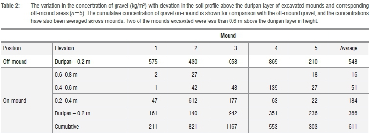
In the inter-mound area, the surface gravel was relatively uniformly exposed, or buried below small accumulations of sediment around vegetation (Figure 1a). The off-mound gravel proportions per size class were 0%>31.5 mm, 23%>16 mm, 61%>8 mm and 15%>5 mm, and the on-mound gravel (averaged over all depths) comprised 9%>31.5 mm, 21%>16 mm, 54%>8 mm, 16%>5 mm. The gravel was mainly quartz with some shale fragments. In contrast, the density of gravels on the mound surfaces was much lower, although some gravel was still present throughout the profile. At the depth of the maximum accumulation of gravel within the mound, the average gravel concentration was similar on average to that off-mound, although the variance was high between mounds (Table 2).
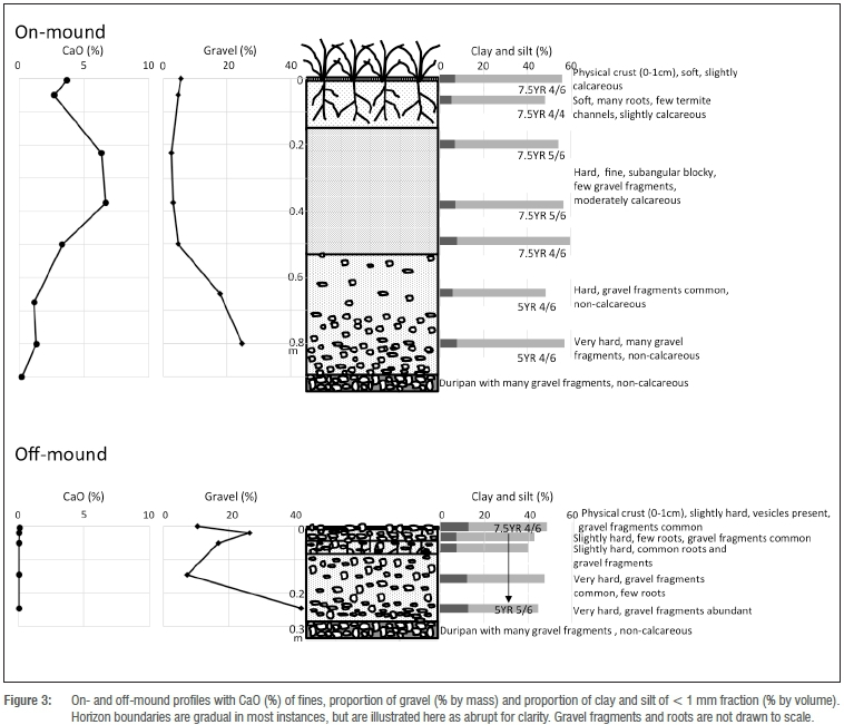
The soil profile (Figure 3) confirmed the presence of a concentrated gravel layer situated on top of an impenetrable duripan layer both on- and off-mound. From a sample taken using a hammer and chisel, this gravel continued into the duripan layer. The profile for this mound showed a significant reduction in gravel in the horizons above this concentrated gravel layer. This mound profile has a horizon that is only moderately calcareous, with no petrocalcic horizons present in the profile. The off-mound profile also has an increased concentration of gravel above an impenetrable duripan layer. Upwards, this gravel concentration first decreases and then increases again towards the surface.
In the large mound for which a profile was described (Figure 4), gravel-sized fragments within a matrix of fines did not occur throughout the profile, although fragments of carbonate nodules did. The diagenetic carbonate accumulations and well-developed petrocalcic horizon occurred at 0.95 m depth and was associated with a duripan layer. This petrocalcic horizon varied from solid calcrete to accumulations of duripan containing no carbonate but also quartz gravel fragments. Below this calcrete is a layer of sub-rounded and angular carbonate nodules ranging in size from pebbles to larger cobbles20 in a matrix of fines. This nodular carbonate accumulation becomes very dense and excavations were stopped at 1.8 m where it became difficult to penetrate any deeper.
Soil particle size
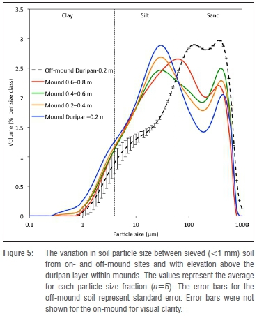
Both on- and off-mound soils can be classified as poorly sorted, fine sandy loam at all sampled depths.24 The lack of sorting is also evident is surprising, but may indicate some marine influence.28,29 Strontium isotopes and 513C values in heuweltjie calcrete at Clanwilliam were not similar to that in surrounding geology, leading to the suggestion that they may be of marine origin.12 Interception of atmospheric nutrients by vegetation is not unusual30 and thus, in addition to vegetation trapping aeolian sediment to form the mound and concentrating nutrients, plants may additionally intercept nutrient particulates and aerosols, consequently enriching the soil over prolonged periods.
The off-mound profile particle size shows a variation from higher clay content on the surface, decreasing below this and then increasing again towards the duripan (Figure 3). The increased clay content on the surface is because of the vesicular, physical crusting present in the first 0-0.01 m as a result of fluvial deposition of fine material. The average off-mound particle size distribution (Figure 5) shows a large variation in values for the silt and clay particle range.
Soil and rock chemistry
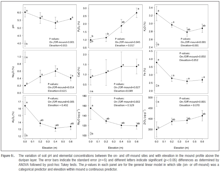
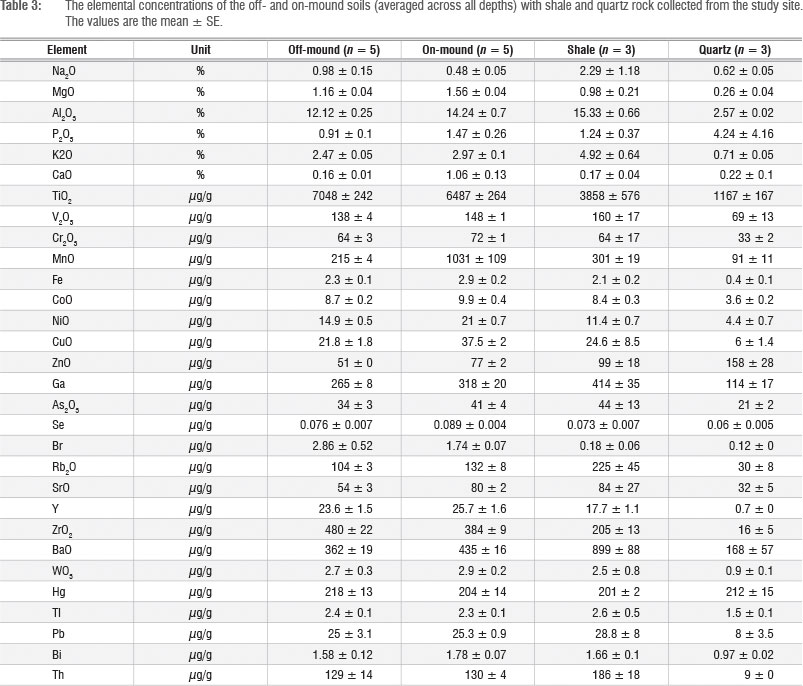
Soil pH was lower off-mound than on-mound and a linear model for pH with depth revealed a significant (p=0.015) increase in pH with elevation above the duripan layer on-mound (Figure 6, Table 3). Concentrations of P K, Ca, Fe, Al and Rb were significantly higher and Na and Zr lower on-mound than off-mound (Figure 6). There were significant increases in P and Ca and decreases in K with elevation above the duripan layer on-mound. Off-mound soil elemental composition was strongly correlated with shale composition (Figure 7), but less strongly related to quartz (i.e. slope=0.89, intercept=0.53, r=0.87). Concentrations of Br, Zr and Ti were higher and Na and K lower than the 95% confidence interval on the regression of off-mound soil relative to shale. The elemental composition of on-mound soil (averaged across all depths) was less strongly correlated with shale composition than for off-mound soils (Figure 7). Concentrations of Ca, Br, Zr, Mn and Ti were higher and Na and K lower than the 95% confidence interval in the regression of on-mound soil relative to shale.
Discussion
We found that all mounds comprised largely fine soils and little gravel with the gravel layer at the same plane as that off-mound. The degree of pedogenesis was greater off- than on-mound, consistent with McAuliffe's7 findings. Together these observations support the hypothesis that the mound sediments are of aeolian origin, deposited over an existing gravel layer, rather than eroded from a former gravel-containing land-surface. Although traces of termites were found in the mounds, if they had played an important role in heuweltjie formation, we would have expected within mound gravels to be substantially lower in elevation than those off-mound.2 The relative absence of gravel in the upper layers of the mound sediments is also unlikely to be the result of extensive termite bioturbational lowering of gravels, because the gravel layer lower down the soil profile is largely intact and at the elevation of the off-mound soil surface. This is substantiated by the fact that the depth of the gravel layer in the mound is correlated with the height of the mound above the surrounding landscape. The sizes of the gravel were also comparable between the on- and the off-mound sites. The proportion of gravel in the smaller mound profile above the concentrated gravel layer was less than 5% of the total amount of gravel in the profile (Figure 3). Thus, although there was some gravel in the mound above the gravel layer, this was a small proportion of the total amount. There was evidence at the study site of significant fossorial activity (rodent, porcupine and aardvark) on the mounds, making it likely that fauna redistributed some of the gravel upwards within the profile of the mounds.
A previous analysis by Cox et al.2 of the small-sized stone content of heuweltjies supported the role of termites and fossorial animals. Because fewer stones were observed on- than off-mound, this led to the erroneous conclusion that bioturbation had led to the sinking of stones through the soil profile. However, these authors noted the limitation of their study and study site; the study mainly focused on surface layers (0-0.15 m depth), it took place in some heuweltjies where the concretionary calcrete layer prevented excavation beyond 0.3-0.4 m and these authors did not separate concretionary calcrete rocks from non-concretionary rocks. Furthermore, these authors did not consider that the lack of stones in surface layers may also be the result of aeolian deposition, rather than only being because of bioturbation. Our study site had the advantage of the continuous ancient gravel layer over a duripan, providing an indication of the previous soil surface.
Similar to previous reports,7,13 there were differences between particles sizes on- and off-mounds. Movement of sediments by wind depends on the sizes of the sediment particles and the power of the wind.25 Based on a compilation of studies of dust, Lawrence et al.26 concluded that local dust deposition consists predominantly of coarse silts and/or fine sands, with 10-60% (by mass) of the particles being smaller than 20 μm. Local dust generally also contains large fractions of fine silt (25-60%) and clay (10-40%). Regional dust, on the other hand, consists of less coarse silt and fine sands and a larger proportion of fine silt, but it has a clay content similar to local (within the same geological context) deposition. The particle size analysis reported here with greater concentrations of fine particles on-mound is thus consistent with a local source of sediment, as detailed by Lawrence et al.26 In contrast, McAuliffe et al.7 speculated that sediment at their site was derived from the coast and/or nearby dune fields. The local origin of sediments at our site is substantiated by elemental analysis, which showed that both on- and off-mound soils were strongly correlated with the elemental composition of shale rock sampled upslope from the mounds. McAuliffe et al.7 concluded that sediments at their sites were well sorted. In contrast, the sediment sampled in this study was classified as poorly sorted. This could be the result of the better resolution provided by the laser diffraction particle size analysis compared to the hydrometer method. The occurrence of greater amounts of silt on- than off-mound is consistent with preferential aeolian deposition to the mounds, but accompanied by preferential loss of silt from the off-mound area and formation of a physical crust with vesicular porosity in places because of the wetting and drying cycles of fluvial action.27
Strong differences in elemental concentrations between on- and off-mound soils have been noted previously13,14 and are generally regarded as the consequence of biotically (i.e. termite) induced accumulation of elements on-mound. It is possible, however, that off-mound elemental concentrations may be lower than those on-mound because of greater leaching of off-mound soils as a result of greater drainage through these lower elevation areas. The fact that concentrations of the relatively immobile elements Zr and Ti in off-mound soils are above the 95% confidence band of the correlation between off-mound soil and shale and that the slope of the line is less than 1 indicates that leaching of other more mobile elements has indeed occurred. Despite this general trend, some elements (notably Ca and Mn) have accumulated relative to other elements in mound soils, as the concentrations lie above the 95% confidence band for the correlation between on-mound soils and shale. The fact that Br is high in both on- and off-mound soils relative to shale
This site appears to have much in common with the inland mounds studied by McAuliffe et al.7 Similar to their Soebatsfontein mounds, the mounds in this study showed great diversity in the development of calcic horizons. The biggest mound surveyed had a well-developed calcrete layer (0.95 m) in combination with a reddened (5YR) argillic duripan layer. This calcrete layer appears to have formed in gravelly materials.31 The smaller mound profiled (Figure 3) was only moderately calcareous at a depth of between 0.2 m and 0.4 m (7.5YR 5/6), but no distinct structural or textural differentiation at this level, and no significant petrocalcic horizons were present in the mound. McAuliffe et al7 highlight the fact that the presence or absence of calcic horizons could be the result of significant age or developmental differences between the mounds because of the time-dependence of the formation of such horizons. The two mounds profiled here are in very different positions in the landscape, which could also contribute to significant developmental differences in the mounds. Furthermore, the horizons above the calcrete on the larger mound were softer, less-cohesive and easier to sample than those of the smaller mound, contrary to what one might expect based on the presence of the well-developed calcic horizon. This could imply younger sediments accumulated on an older, previously existing surface. In addition, McAuliffe et al.7 also identified a 'strongly indurated, silica-cemented duripan' in the off-mound areas at 0.3 m depth. A similar reddened, cemented duripan was present on-and off-mound in the present study area, in conjunction with and just below a concentrated gravel layer. The horizons above this layer on-mound contain similar fine-textured sediments throughout the mound with limited pedogenic alteration, which combined with the lack of gravel supports the role of aeolian deposition.
Of the elements analysed (Figure 7), only Na and Zr were at significantly higher concentrations off- than on-mound (Figure 6). While Na is relatively mobile in soils and could be readily leached from the lower elevation off-mound soils, Zr is considered relatively immobile34 and is likely to be higher in the off-mound soils because of loss of other elements associated with finer soil fractions. The on-mound accumulation P, K, Ca, Fe, Al and Rb and higher pH relative to off-mound sites may also be associated with the greater silt content of the mound soils, because like these finer particle sizes, these elements increased in concentration with depth through the mound profile. This indicates that there is a degree of pedogenic development within the mounds, substantiating the antiquity of the mounds. The significant increase in P concentration with elevation above the duripan may indicate plant depletion of this regionally scarce resource,35 particularly from deeper and older horizons within the mound.
The results presented are consistent with aeolian deposition occurring preferentially on mounds as a result of increased surface roughness and sediment trapping provided by vegetation clumps. Alternatively, regional aeolian sediments deposited over a gravel plain might subsequently have been eroded, leaving mounds associated with vegetation clumps that reduce erosion. McAuliffe et al.7 argued that the absence of pedogenically advanced layers on-mound ruled out the erosion hypothesis, because, if these sediments were part of a much older surface, the on-mound horizons should have undergone substantially more pedogenesis than is evident. Furthermore, for most sites where heuweltjies occur there is no evidence of extensive mantling by aeolian sediment, apart from that associated with the mounds. The mounds thus differ from the surroundings by having less pedogenically developed soil and distinct vegetation. Based on texture and elemental analysis, the sediment at our study site and that at the site studied by McAuliffe et al7 is of local origin, making it unlikely that it was part of a regional mantling by aeolian sediment.
Although a predominantly erosional hypothesis seems unlikely, fluvial erosion of sediments and channelling of water between mounds is potentially an important process maintaining the sediment and profile differences between on- and off-mound areas. McAuliffe et al.7 previously noted differences in pedogenic development between surface layers on-and off-mounds and suggested that this reflected the longer period that off-mound soils have had to develop. Our analysis suggests that the buried surface within mounds and associated duripan development does not differ strongly with that off-mound. The existence of physical crust with vesicular porosity and drainage lines at our study site, however, indicates the important contribution of fluvial processes to mound formation, and particularly the off-mound soils. Comparing the heuweltjie landscape morphology to analogous modern landforms and processes, like drainage patterns and nebkhas, provides clues to the processes that shaped them. Seifert et al.8 concluded that the mounds they studied in Arkansas are relict nebkha dunes even though the centimetre-resolution profile of one of the mounds revealed only a slight asymmetry. The absence of features associated exclusively with water erosion, such as distinct terrace structures, potentially precludes an exclusively water erosion hypothesis, especially taking into consideration the moderate slope at the current site. Unlike for mima-mounds in North America,32 there has never been a suggestion that heuweltjies from different parts of South Africa33 are polygenetic in origin. It is possible, however, that contributory deposition and erosion processes act to different degrees and have site-specific outcomes for pedogenesis. For example, it has been suggested that nebkhas are strongly influenced by local factors such as sediment supply, local climatic conditions, plant density and growth rates and the interaction between these various factors.36
Conclusion
We concur with McAuliffe et al.7 that heuweltjies are predominantly the consequence of aeolian deposition, probably around vegetation clumps. We question the role of termites in the formation of the mounds or their chemical composition. The physical and chemical properties of mounds are consistent with locally derived aeolian sediment deposition, but with some exotic sources of elements such as possibly marine derived Ca and Br delivered via atmospheric transport. We agree that globally, the origins of large earthen mounds are probably polygenetic32, and that in other areas, such as the campos de murundus of Brazil6 and the mima mounds of Washington State37, these may well be primarily formed by erosion, rather than deposition.
Acknowledgements
We are grateful to Edward Chirwa and Kirsten Packer for assisting with field and laboratory work and are very grateful to the reviewers for their useful comments. Funding for this project was received from the University of Cape Town (URC awards).
Authors' contributions
All authors participated in conceptualisation and field sampling. M.D.C. and J.v.H. analysed data and wrote the manuscript. J.J.M. and L.K. edited the manuscript.
References
1. Cramer MD, Midgley JJ. The distribution and spatial patterning of mimalike mounds in South Africa suggests genesis through vegetation induced aeolian sediment deposition. J Arid Environ. 2015;119:16-26 http://dx.doi.org/10.1016/j.jaridenv.2015.03.011 [ Links ]
2. Cox GW, Lovegrove BG, Siegfried WR. The small stone content of Mima-like mounds in the South African cape region: Implications for mound origin. Catena 1987;14:165-176. http://dx.doi.org/10.1016/S0341-8162(87)80015-2 [ Links ]
3. Lovegrove BG. Mima-like mounds (hueweltjies) of South Africa: The topographical, ecological and economic impact of burrowing animals. Symp Zool Soc Lond. 1991;63:183-198. [ Links ]
4. Moore JM, Picker MD. Heuweltjies (earth mounds) in the Clanwilliam District, Cape Province, South Africa: 4000-year-old termite nests. Oecologia. 1990;86:424-432. http://dx.doi.org/10.1007/BF00317612 [ Links ]
5. Cramer MD, Innes SN, Midgley JJ. Hard evidence that heuweltjie earth mounds are relictual features produced by differential erosion. Palaeogeogr Palaeoclimatol Palaeoecol. 2012;350-352:189-197. http://dx.doi.org/10.1016/j.palaeo.2012.06.030 [ Links ]
6. Silva LCR, Vail GD, Haidar RF, Sternberg LdaSL. Deciphering earth mound origins in central Brazil. Plant Soil. 2010;336:3-14. http://dx.doi.org/10.1007/s11104-010-0329-y [ Links ]
7. McAuliffe JR, Hoffman MT, McFadden LD, King MP Role of aeolian sediment accretion in the formation of heuweltjie earth mounds, western South Africa. Earth Surf Process Landforms. 2014;39(14):1900-1912. Available from: http://dx.doi.org/10.1002/esp.3583 [ Links ]
8. Seifert CL, Cox RT, Forman SL, Foti TL, Wasklewicz TA, McColgan AT. Relict nebkhas (pimple mounds) record prolonged late Holocene drought in the forested region of south-central USA. Quat Res. 2009;71:329-339. http://dx.doi.org/10.1016/j.yqres.2009.01.006 [ Links ]
9. Midgley JJ, Harris C, Hesse H, Swift A. Heuweltjies; age, origins and vegetation change based on 13C and 14C analyses. S Afr J Science. 2002;98:202-204. [ Links ]
10. Francis ML, Ellis F, Lambrechts JJN, Poch RM. A micromorphological view through a Namaqualand termitaria (Heuweltjie, a Mima-like mound). Catena. 2013;100:57-73. http://dx.doi.org/10.1016/j.catena.2012.08.004 [ Links ]
11. Potts AJ, Midgley JJ, Harris C. Stable isotope and 14C study of biogenic calcrete in a termite mound, Western Cape, South Africa, and its palaeoenvironmental significance. Quat Res. 2009;72:258-264. http://dx.doi.org/10.1016/j.yqres.2009.04.008 [ Links ]
12. Midgley JJ, Harris C, Harington A, Potts AJ. A geochemical perspective on the origins and consequences of heuweltjie formation in the southwestern Cape, South Africa. S Afr J Geology. 2012;115(4):577-586. http://dx.doi.org/10.2113/gssajg.115.4.577 [ Links ]
13. Midgley GF, Musil CF. Substrate effects of zoogenic soil mounds on vegetation composition in the Worcester-Robertson valley, Cape Province. S Afr J Bot. 1990;56:158-166. [ Links ]
14. Kunz NS, Hoffman MT, Weber B. Effects of heuweltjies and utilization on vegetation patterns in the Succulent Karoo, South Africa. J Arid Environ. 2012;87:198-205. http://dx.doi.org/10.1016/j.jaridenv.2012.05.007 [ Links ]
15. Shreve E, Mallery TD. The relation of caliche to desert plants. Soil Sci. 1933;35:99-112. http://dx.doi.org/10.1097/00010694-193302000-00002 [ Links ]
16. Schlesinger WH, Pilmanis AM. Plant-soil interactions in deserts. Biogeo-chemistry. 1998;42:169-187. http://dx.doi.org/10.1023/A:1005939924434 [ Links ]
17. Fall S, Brauman A, Chotte J-L. Comparative distribution of organic matter in particle and aggregate size fractions in the mounds of termites with different feeding habits in Senegal: Cubitermes niokoloensis and Macrotermes bellicosus. Appl Soil Ecol. 2001;17:131-140. http://dx.doi.org/10.1016/S0929-1393(01)00125-1 [ Links ]
18. Schmiedel U, Mucina L. Vegetation of quartz fields in the Little Karoo, Tanqua Karoo and eastern Overberg (Western Cape Province, South Africa). Phytocoenologia. 2006;36:1-44. http://dx.doi.org/10.1127/0340-269X/2006/0036-0001 [ Links ]
19. Gerlach RW, Dobb DE, Raab GA, Nocerino JM. Gy sampling theory in environmental studies. 1. Assessing soil splitting protocols. J Chemometrics. 2002;16:321-328. http://dx.doi.org/10.1002/cem.705 [ Links ]
20. Williams SJ, Arsenault MA, Buczkowski BJ, Reid JA, Flocks JG, Kulp MA, et al. Surficial sediment character of the Louisiana offshore continental shelf region: A GIS compilation. U.S. Geological Survey (USGS) Open-File Report 2006;1195. Reston, VA: USGS; 2007. Available from: http://pubs.usgs.gov/of/2006/1195/index.htm [ Links ]
21. Food and Agriculture Organization of the United Nations (FAO). Guidelines for soil description. 4th ed. revised. Rome. FAO; 2006. [ Links ]
22. R Development Core Team. R: A language and environment for statistical computing. Vienna: Foundation for Statistical Computing; 2014. [ Links ]
23. Midgley GF, Musil CF. Substrate effects of zoogenic mounds on vegetation composition in the Worcester-Roberston valley, Cape Province. S Afr J Bot. 1990;56:158-166. [ Links ]
24. Blott SJ, Pye K. Gradistat: A grain size distribution and statistics package for the analysis of unconsolidated sediments. Earth Surf Process Landforms. 2001;26:1237-1248. http://dx.doi.org/10.1002/esp.261 [ Links ]
25. Pye K. Aeolian dust and dust deposits. London: Academic Press; 1987. http://dx.doi.org/10.1016/B978-0-12-568690-7.50010-7 [ Links ]
26. Lawrence CR, Neff JC. The contemporary physical and chemical flux of aeolian dust: A synthesis of direct measurements of dust deposition. Chem Geol. 2009;267:46-63. http://dx.doi.org/10.1016/j.chemgeo.2009.02.005 [ Links ]
27. Figueira H, Stoops G. Application of micromorphometric techniques to the experimental study of vesicular layer formation. Pedologie. 1983;33:77-89. [ Links ]
28. Moyers JL, Duce RA. Gaseous and particulate bromine in the marine atmosphere. J Geophys Res. 1972;77:5330. http://dx.doi.org/10.1029/JC077i027p05330 [ Links ]
29. Saiz-Lopez A, Plane JMC. Bromine oxide in the mid-latitude marine boundary layer. Geophys Res Lett. 2004;31:4-7. http://dx.doi.org/10.1029/2003GL018956 [ Links ]
30. Martorell C, Ezcurra E. The narrow-leaf syndrome: A functional and evolutionary approach to the form of fog-harvesting rosette plants. Oecologia 2007;151:561-573. http://dx.doi.org/10.1007/s00442-006-0614-x [ Links ]
31. Gile LH, Peterson FF, Grossman RB. Morphological and genetic sequences of carbonate accumulation in desert soils. Soil Sci. 1966;101:347-360. http://dx.doi.org/10.1097/00010694-196605000-00001 [ Links ]
32. Johnson DL, Horwath-Burnham J. Introduction: Overview of concepts, definitions, and principles of soil mound studies. Geol Soc Am. Special Paper. 2012;490:1-9. http://dx.doi.org/10.1130/2012.2490(00) [ Links ]
33. Cramer MD, Midgley JJ. The distribution and spatial patterning of mima-like mounds in South Africa suggests genesis through vegetation induced aeolian sediment deposition. J Arid Environ. 2015;119:16-26. http://dx.doi.org/10.1016/j.jaridenv.2015.03.011 [ Links ]
34. Kurtz AC, Derry LA, Chadwick OA, Alfano MJ. Refractory element mobility in volcanic soils. Geology. 2000;28:683-686. http://dx.doi.org/10.1130/0091-7613(2000)28<683:REMIVS>2.0.CO;2 [ Links ]
35. Cramer MD, West AG, Power SC, Skelton S, Stock WD. Plant ecophysiological diversity. In: Allsopp N, Colville JF, Verboom GA, Cowling RM, editors. Fynbos: Ecology, evolution, and conservation of a megadiverse region. Oxford: Oxford University Press; 2014; p. 248-272. http://dx.doi.org/10.1093/acprof:oso/9780199679584.003.0011 [ Links ]
36. Tengberg A, Deliang C. A comparative analysis of nebkhas in central Tunisia and northern Burkina Faso. Geomorphology. 1998;22:181-192. http://dx.doi.org/10.1016/S0169-555X(97)00068-8 [ Links ]
37. Cramer MD, Barger NN. Are mima-like mounds the consequence of long-term stability of vegetation spatial patterning? Palaeogeogr Palaeoclimatol Palaeoecol. 2014;409:72-83. http://dx.doi.org/10.1016/j.palaeo.2014.04.026 [ Links ]
 Correspondence:
Michael Cramer
Department of Biological Sciences
University of Cape Town
Private Bag X3, Rondebosch 7701
South Africa
michael.cramer@uct.ac.za
Received: 22 Jan. 2015
Revised: 24 June 2015
Accepted: 01 Aug. 2015

