


Services on Demand
Article
 English (pdf)
 Article in xml format
 Article references
Indicators

Related links
-
 Cited by Google
 -
 Similars in Google
Share

 Permalink
South African Journal of Science
On-line version ISSN 1996-7489
Print version ISSN 0038-2353
S. Afr. j. sci. vol.108 n.1-2 Pretoria Jan. 2012
REVIEW ARTICLE
The first stratigraphic column in South Africa, from Hondius (1652), and its modern correlatives
Sharad Master
Economic Geology Research Institute, School of Geosciences, University of the Witwatersrand, Johannesburg, South Africa
ABSTRACT
In 1647 the Dutch ship Haarlem, en route from Batavia to the Netherlands Republic, was wrecked in Table Bay. The survivors were encamped over the next year before they were rescued in a fort they constructed called Sandenburgh. Their successful sojourn in the Cape led directly to the establishment of the Dutch colony there in 1652. They survived by living on hunted cormorants and penguins, bartered cattle and sheep, and by drinking fresh water obtained from a well which they sank to a depth of 20 m. The sequence of sediments encountered in the well was recorded by Jodocus Hondius III, grandson of the famous mapmaker, in a book published in 1652, based on accounts given to him by the sailors from the Haarlem. A comparison of the stratigraphy recorded in the well (five sedimentary units) with the Pleistocene and Holocene stratigraphy known from modern studies of these coastal sediments, shows a very good correspondence in terms of lithologies and thicknesses, and attests to the veracity of the sources that provided Hondius with his information. This singular case of a detailed stratigraphic column is interesting in the light it throws on the rudimentary understanding of rock types, stratigraphy and hydrology by Dutch sailors in the mid-17th century, at the beginnings of South African colonial history, more than a decade before the study of stratigraphy was initiated by the work of Steno. The measurements recorded in the description of the well are some of the earliest quantitative data recorded in the history of South African science.
Introduction
The beginnings of stratigraphic investigations in South Africa are generally attributed to the activities of the road engineer Andrew Geddes Bain in the early to mid-19th century.1,2,3,4,5 Sporadic accounts and descriptions of aspects of South African geology are known from earlier times,3,6 but stratigraphic information is generally lacking in the earlier reports, with the notable exception of the account by Barrow7 (1801) of the boreholes drilled at Wynberg and at the foot of Tygerberg near Cape Town in the search for coal in 1797.8
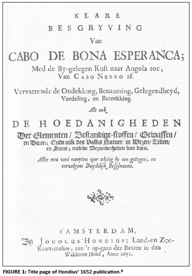
The earliest account of South African stratigraphy is to be found in a book published in 1652 by Jodocus Hondius III9 (1622-1655), grandson of the famous Dutch mapmaker and engraver Jodocus Hondius (1563-1612) and son of Jodocus Hondius Jr (1595-1629), and was based on information supplied by survivors of the wrecked ship Haarlem. An original copy of this very rare book (Figure 1) is in the Fairbridge Collection of the National Library of South Africa in Cape Town. The book was translated into English for the first time and published in 1952 during the celebrations marking the tercentenary of the establishment of the Dutch Colony at the Cape.10
Wreck of the Haarlem in Table Bay in 1647
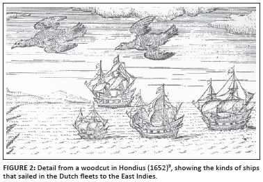
Following on the discovery of the sea route to the Far East by the Portuguese in the late 15th and the 16th centuries, the Dutch had firmly established their trading empire in the East Indies in the 17th century through the activities of the Vereenigde Oost-Indische Companij (VOC), the Dutch East India Company.11,12 The Dutch had their East Indian headquarters in Batavia (now Djakarta), on the island of Java (in present-day Indonesia), and a continuous stream of merchant ships (Figure 2) sailed between the Staten van Holland (that made up the 'Republiek der Verenigde Provincien', hereinafter referred to as the Netherlands Republic) and Batavia by the mid-17th century.
On 16 January 1647, a fleet of three ships, the 500 tonne Haarlem, the 1000 tonne Witte Olifant and the 800 tonne Schiedam, under the command of Vice-Commander Reinier van 't Zuim (aboard the Witte Olifant) left Batavia, for the return journey to the Netherlands Republic.13 On 25 March 1647, the ships called and anchored at Table Bay, between Robben Island and the mainland, when a strong south-easterly gale sprang up and the Haarlem, with 120 people aboard, was driven ashore and stranded near the present Milnerton Beach.13,14 Note that the name of this ship is given as Haerlem in Van Riebeeck's journal15 and in van Oordt's English translation of Hondius,10 and as Nieuw Haarlem by Turner14, but, according to the records of the shipping registers in Batavia, it is Haarlem,13 and the same name is also given in Hondius' Dutch original in 1652.9 Bokhorst16 lists the ship under the name Haarlem, but says that more precisely it should be Nieuwe Haerlem. Gribble and Athiros17 called it the Nieuw Haerlem.
The captain of the Haarlem, Pieter Pieterszoon, continued the journey in another vessel, but a party under the leadership of Leendert Janssen (Janszoon) was ordered to remain behind. The other two ships of the return fleet survived the storm, and continued their homeward journey via St Helena, with the Witte Olifant arriving in Texel on 09 August 1647, and the Schiedam arriving in Goeree on the next day.13 The return fleet brought with it a letter by Leendert Janssen, dated 6 April 1647, addressed to the Lords XVII (the directors of the VOC), in which he makes mention of a well that was dug by the shipwrecked crew of the Haarlem.18
The Haarlem was laden with a valuable cargo which consisted of pepper, cinnamon, candy sugar, gold cloth, Chinese porcelain and indigo.12,14 The stranded crew of the Haarlem were tasked with trying to salvage the cargo. They built a 450 foot square temporary fort, called Zandenburch17 or Sandenburgh,19 for protection from the indigenous Khoekhoe, used water from the well, obtained salt from the nearby salt marshes along the Diep River, and lived off penguins, penguin eggs and cormorants caught or collected during foraging parties on nearby Robben Island.20,21 They also traded copper and tobacco for cattle and sheep with men from Saldanha (a Khoekhoe tribe known as the Goringhaiquas).15 The crew lived at the site for about a year before they were eventually rescued on 03 April 1648 by another fleet, under the command of Admiral Wollebrant Geleijnszoon de Jongh, amongst whose number was a young man named Jan van Riebeeck.16 When the crew were finally repatriated to Holland, they reported favourably on the Cape, and, in a famous letter to the VOC - the 'Remonstrantie', Janssen and Proot22 argued the case for making the Cape a stopping point for ships journeying to and from the Far East. Van Riebeeck23 then sent a detailed memorandum to the directors of the VOC, in which he discussed at length the views of Janssen and Proot.15 The VOC consequently decided to establish a refreshment station at the Cape in 1652, under the command of Van Riebeeck.
As a prelude to the Dutch occupation of the Cape peninsula, there was a demand for information about the Cape. This demand was duly satisfied by Jodocus Hondius III, who had never been to the Cape. Hondius compiled a description of everything that was known about the Cape from previously published writings by travellers over the past century and a half, as well as by descriptions furnished by the first Dutch expedition of 1595, and by the crew of the wrecked ship Haarlem.10 Another view24,25 is that the work is an anonymous compilation, and was only published by Hondius.
Hondius' descriptions of the Cape in 1652
Hondius (1652)9 gives the following description of the fate of the ship Haarlem, and its crew (Figure 3; Passage A in the online supplementary material) (translated by L.C. van Oordt,10 together with a footnote by Professor P. Serton):
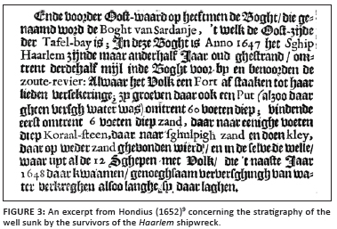
On the eastern side of Table Bay is the Bight of Sardanje, where the Haerlem came to grief in 1647 about two and a half miles along the Bight, north of the Salt Rivera. The ship had been built merely one and a half years previously. The shipwrecked crew marked out a fort for their protection, and as there was no water, they dug a well about sixty feet deep. They first found a layer of sand six feet deep and then coral limestone a few feet thick; then there was shelly sand followed by clay. Below that, more sand was found, and from this came the well. The twelve ships that came there the next year, 1648, obtained sufficient water from it for their crews while they remained there.
Note that in the quoted passage, the 'Bight of Sardanje' refers to the area immediately adjacent to the modern Table Bay, as is clear from the map accompanying Hondius' description (Figure 4). The bay was originally called the Agoada da Saldanha (the 'Watering Place of Saldanha'), after Antonio de Saldanha who visited it in 1503, and this name persisted for over a century, until Joris van Spilbergen erroneously thought he had discovered a new bay, which he called 'Tafel Baay' (after Table Mountain), and the name has remained to this day.26 Table Bay is too cold for coral, and the original term 'Koraal-steen'9 should have been translated as 'limestone'. Hondius9,10 gives the following descriptions (translated by L.C. van Oordt with corrections)10 of the landscape, soils and hydrology of the area and its mineral resources (the footnotes are given in the original text, which is Passage B in the online supplementary material9)b:
A short distance beyond the tail of the Lion Mountain is the little Fresh River which is a stream rising in the foothills of Table Mountain, or in its higher slopes. The river usually flows quite strongly, but in most parts the water does not reach above the knees. In the year 1644 the crew of the wrecked ship Mauritius marked out a fort with 4 bastions across this Fresh River in order to protect the fresh water, but no building took place until this present year, 1652, when a fortress was begun on the eastern side of the same streamlet.
Approximately half a mile eastward in Table Bay is a river extending inland, named the Jacqueline by George Spilbergen. In my opinion this is the river which is about half a mile to the east of the Fresh River and called the Salt River, a stone's throw in width.
About a third or quarter of a mile to the right there is a small branch stream welling up like a little fountain and joining this one. Three or four miles up this Salt River there is a large patch of sand on which, in hot, dry weather sometimes so much pure white salt crystallizes (a hand's breadth deep), that it would be possible to take away a shipload of it.
....
In this region the earth is here and there very good for sowing, and is fit and suitable for living and for the cultivation of all kinds of fruit. The soil is very full of stones, shells and in some places, alternating with patches of clay and fertile soil. There are soft, white sandstones, limestones, and shelly sand, and crystallizations of pure white salt are also found.
Minerals
There is ample soft white sandstone, limestonei and shells; pearlsk and natural deposits of fine white salt are also availablel.
Note that among the sources listed for his information, Hondius9 gives the Survivors of the Shipwreck of the Haarlem, and the First Dutch Voyage of 1595, being the first voyage to the East Indies, under the command of Cornelis de Houtman.27 Among the minerals there is mention of pearls, with the source of the information being Houtman's voyage. There are no pearls in the Western Cape, so the informants were mistaken - they may have been referring to nacre, or mother-of-pearl (e.g. in abalone shells, known in the Cape today as 'perlemoen'). The rivers and streams mentioned by Hondius9,10 have their modern equivalents as follows: the Fresh River ('zoete Rivierjen'9) is the modern Platteklip stream; the river called by Spilbergen the 'Jacqueline', and by Hondius the 'Salt', is the modern Diep River. Such abundance of salt as mentioned by Hondius9,10 is rare today on the Cape Peninsula; now the harvesting of salt occurs further to the north at Yzerfontein and Velddrif, which may be because of changes in the climate or hydrology of the Diep River system.
Location of the Sandenburgh site
Concerning the location of the site of the wreck of the Haarlem, and of the fort Sandenburgh, erected by its shipwrecked crew, Raven-Hart28 had this to say:
Hondius locates the wreck as in 'Sardaigne Bay' (a curioussurvival of the old name, now for a bight) at'milesc from' the Table Bay roads, and his map agrees, suggesting therefore a spot slightly south of Bloubergstrand. A letter from Van Riebeeck to Batavia dated May 25, 1652, however, gives 'fully 3 miles' from where he was building his fort, which better fits Skulpbaai.
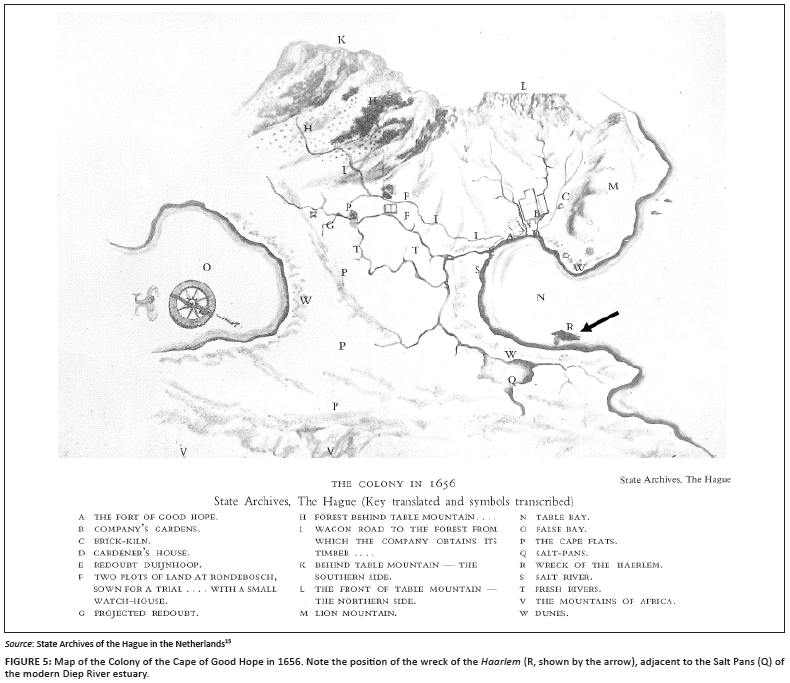
Knox-Johnston12 took Raven-Hart's calculation at face value, and repeated the assertion that the position of the wreck was at Skulpbaai. A Dutch mile is actually 4.611 statute English miles, or about 7.4 km,29 which places the wreck at about 22.2 km northwards along the coast from Van Riebeeck's fort (the 'Castle' in Cape Town), corresponding to a position about 3 km north of Bloubergstrand. However, an entry for 20 May 1652, in Van Riebeeck's journal mentions that he paid a visit to the wreck of the Haarlem which was still buried in the sand, and that in that vicinity there were salt deposits in fair abundance.15 A further entry for 29 January 1659 in the same journal, mentions that an expedition was made to look for salt along the river which Van Riebeeck called 'Hollants Rietbeecq', now known as the Diep River, close to where the Haarlem had been stranded.15 The Diep River, and the Rietvlei estuary into which it enters, dry up during the summer months, with the estuarine lagoon becoming hypersaline and depositing salt in salt marshes30,31,32 - the salt that the expedition mentioned by Van Riebeeck had been after and the locality of the deposits of 'sghoon wit Zout' or 'pure white salt' mentioned by Hondius9,10. So, from the description of its location in Van Riebeeck's journal,15 as well as that by Hondius9,10, there can be no doubt about the position of the wreck and of Sandenburgh, which is unequivocally placed near the estuary of the Diep River, that is, close to the present Milnerton Beach. This position is in accordance with the calculation made by Serton.10 The position of the wreck of the Haarlem is also given on a map of the Cape Colony in 1656, which is stored in the State Archives in the Hague and was reproduced by Thom15 (Figure 5) and in a chart of Table Bay from 1664 (in the Leupe Collection, also in the Hague archives).17 Werz33 published a later but more accurate map, drawn in 1786, from the VOC Archives in the Hague, which depicts the location of the Haarlem campsite amongst the dunes due west of Rietvlei, east of Whale Rock, south of Table View, and well north of the Diep River estuary and the modern Milnerton lighthouse, probably just north of the modern Sunset Beach. Shards of Chinese porcelain, supposedly from the wreck of the Haarlem, have been found on the beach a little north of the Milnerton lighthouse, near the presumed position of the shipwreck.14 However, the finds of porcelain by themselves are not conclusive because 40 years after the wreck of the Haarlem, another homeward-bound Dutch ship, the Oosterland, was wrecked on 24 May 1697, in the same area, south of the estuary of the Diep River.13,14,33,34,35
Stratigraphy of the Sandenburgh site and its modern correlatives
The coastal region of the Western Cape Province, stretching northwards from Cape Town towards Saldanha Bay is dominated by Cenozoic sedimentary rocks ranging in age from Miocene to Recent, overlying a basement consisting of the Neoproterozoic Malmesbury siltstones and Cape granites.36,37,38,39,40,41,42,43 Rogers38 divided the Cenozoic rocks of this coastal stretch into the Elandsfontyn (Late Miocene), Varswater (Early Pliocene) and Bredasdorp (Pleistocene to Holocene) Formations.
The Diep River estuary was studied in great detail, utilising borehole cores, by Schalke36. This area of the coast is characterised by aeolian transport of siliciclastic sand, brought to the coast by rivers draining the inland mountains.41,44 Farther north there is an increase in the proportion of carbonate sand, made up mainly of fragments of the molluscs Choromytilus meridionalis, Donax serra and Patella spp.44 On the seaward side of the Diep River estuary, near the site of the wreck of the Haarlem and of the fort Sandenburgh, exposures of shelly deposits on raised beaches were uncovered by storms in 1974 and 1983, and were described by Kensley45,46. Kensley45 gives the following description of the strata near Milnerton:
In June 1974, during the heavy winter weather experienced in Table Bay, a NW storm coincided with a spring tide. The resultant exceptionally high and powerful wave action scoured away a section of the beach and fringing sand dunes just below the Milnerton lighthouse, and exposed a deposit of shells, containing abundant remains of the common black mussel Choromytilus meridionalis, as well as those of species which do not now occur in Table Bay or the West Coast, thus indicating a Pleistocene age. The deposits are located about 100 m N of the Milnerton lighthouse on the shores of Table Bay. The molluscan shells were dated by Teledyne, New Jersey, USA, using the radiocarbon technique, and yielded an (uncalibrated) age of 33750 ± 1780 years BP, placing the deposit in the middle of the Würm period. The base of the shelly deposit lay on a bed of ferricrete, having a characteristic nodular and cellular structure. Above the ferricrete, there are lenses of black peat-like material, overlain by the shelly bed, which is about 1 m thick. The cementing sediment of the shelly deposit consists of coarse sand grains and shell debris, with occasional scattered rounded pebbles, and a few scattered pieces of limestone rock. There is a crude stratification marked by the alignment of bivalve shells oriented horizontally. At the top of the shelly bed there are gullies filled with black non-fossiliferous sand. Both the shelly bed and the black sand are overlain by a layer of white dune sand.
The shelly sand layer described by Kensley45 corresponds with the shelly sand layer described by Hondius9,10, and it is correlated with the Velddrift Shelly Sand Member of the Bredasdorp Formation.39 The limestone overlying the shelly sand corresponds with the Langebaan Limestone Member, whereas the overlying white dune sand corresponds to the Holocene Witzand Member, both of the Bredasdorp Formation.39 The radiocarbon date quoted by Kensley45 is a minimum age and is unreliable. Luminescence dating of human footprint-bearing sandstone above the same formations on the western shore of the Langebaan Lagoon has yielded ages of 117 kyr, dating from the last interglacial.47 The surface of the late interglacial Velddrift Member is capped by subaerial soil calcrete.39 The ferricrete underlying the shelly layer was regarded by Kensley46 as being homologous to the 'iron-stained gravelly sands' described by Tankard48 from the Ysterplaat area 4 km to the south-east. This layer is equivalent to the Diep River Gravel Bed of Schalke36, and corresponds with the aquifer intersected at 20 m in the well described by Hondius9,10. The clay intersected in the well corresponds in position to some of the peaty material overlying the ferricrete at Milnerton,45,46 and to the Killarney Clay Bed from the Diep River.39 The stratigraphy intersected in the well dug by the Haarlem crew, as described by Hondius9,10, is compared with the modern stratigraphic equivalents in Table 1.
In his description of the salt deposits along the Salt River, Hondius9,10 inadvertently provides the very first estimate of resources and grade for a mineral deposit in South Africa: the salt is 'pure and white' (a qualitative indication of its desirable qualities - a lack of contamination and a high grade) and covers a 'large patch of sand' to a 'hand's depth', capable of providing a 'ship's load' (an indication of tonnage).
Hondius' description10 of 'coral limestone' and 'shelly sand' is the first account of South African fossils (which we now know as being of Pleistocene age45,46) and precedes, by more than a century, the second description - that of fossil shells, from raised beach deposits near Port Nolloth, by William Paterson in 1779.49,50,51
Discussion and conclusions
The stratigraphy of the well dug near Sandenburgh, on the shoreline opposite the site of the wreck of the Haarlem, as described by Hondius9 is comparable to the stratigraphy of the Pleistocene and Holocene formations of the Cape coastal belt, known from modern studies.36,37,38,39,40,41,42,43,44,45,46,47,48 The good correspondence between Hondius' stratigraphic units and the modern data, in terms of lithologies and thicknesses, attests to the veracity of the sources that provided Hondius with his information, namely the survivors of the wreck of the Haarlem.9 The wholly empirical description of strata found in the well predated, by more than a decade, the publication of the two most influential 17th-century works on geology - the Mundus Subterraneus52 of Athanasius Kircher (1665) and the Prodromus53 of Nicolaus Steno (1669), which provided theoretical foundations for hydrology and stratigraphy. In the mid-17th century, the works of Georg Bauer (better known as Georgius Agricola), such as De Natura Fossilium54 (1546) and De Re Metallica55 (1556) were well established in Europe (including in the Netherlands Republic, e.g. at the University of Leiden) as standard texts on mineralogy, mining and metallurgy (in German and in Latin). However, none of Agricola's works, or those of his contemporaries, dealt with stratigraphy, or with the layering of strata.55 It was only in the early 18th century, following the influence of Steno53, that detailed accounts of stratigraphic successions in wells, unconsolidated sediments and in coal mines began to appear in the Philosophical Transactions of the Royal Society in London.56,57,58,59,60
This singular case of a detailed stratigraphic column predates by more than a century the next published accounts of South African stratigraphy, those by Carl Peter Thunberg61 (who gave a very basic stratigraphy of Table Mountain in 1778)62 and John Barrow (1801),7 who gave a description of boreholes near Wynberg. It therefore played no part in the development of geological stratigraphy as a science in South Africa, but is nevertheless interesting in the light it throws on the rudimentary understanding of rock types, stratigraphy and hydrology by Dutch sailors in the mid-17th century, at the beginnings of South African colonial history. Together with the measurements of latitude in early 16th century Portuguese roteiros,63,64 and records of magnetic declination dating from 1595 onwards,65 the observations of the thicknesses of the strata in the well near Sandenburgh are amongst the first quantitative measurements taken in the history of South African science. The application of quantitative and semi-quantitative measurements in the description of the water well and salt resources near the Haarlem wreck site is a harbinger to a whole new way of approaching the natural world, and the exploitation of its resources, which was to change forever the future history of South Africa.
Acknowledgements
I am grateful to Bruce Cairncross, Nic Beukes and two anonymous referees for their comprehensive and diligent reviews, which helped to improve this paper. I acknowledge help from librarians at the William Cullen, Wartenweiler, Geo-Maths and Life Sciences libraries at the University of the Witwatersrand, and at the Jagger Library of the University of Cape Town.
Competing interests
I declare that I have no financial or personal relationships which may have inappropriately influenced me in writing this article.
References
1. Bain AG. On the geology of South Africa. Trans Geol Soc Lond Sec Ser. 1856;7:175-192. [ Links ]
2. Hatch FH, Costorphine GS. The geology of South Africa. London: Macmillan; 1905. [ Links ]
3. Rogers AW. The pioneers of South African geology and their work. Trans Geol Soc S Afr. 1937:29;1-39. [ Links ]
4. Lister MH. Journals of Andrew Geddes Bain: Trader, explorer, soldier, road engineer and geologist. Cape Town: Van Riebeeck Society; 1949. [ Links ]
5. Haughton SH. The father of South African geology. Africana Notes and News. 1964;16;99-108. [ Links ]
6. Rogers AW. An old report on the copper field of Namaqualand. S Afr J Sci. 1917;14:146-152. [ Links ]
7. Barrow J. An account of travels into the interior of Southern Africa in the years 1797 and 1798. London: T. Cadell and W. Davies; 1801. [ Links ]
8. Burman J. The Cape of good intent. Cape Town and Pretoria: Human & Rousseau; 1969. [ Links ]
9. Hondius J. Klare besgryving van Cabo de Bona Esperanca [A clear description of the Cape of Good Hope]. Amsterdam: Jodocus Hondius; 1652. Dutch. [ Links ]
10. Hondius J. A clear description of the Cape of Good Hope. Facsimile of the text compiled by Jodocus Hondius and published by him at Amsterdam in 1652. Cape Town: Book Exhibition Committee, Van Riebeeck Festival; 1952. [ Links ]
11. Boxer CR. From Lisbon to Goa, 1500-1750: Studies in Portuguese maritime enterprise. London: Variorum Reprints; 1984. [ Links ]
12. Knox-Johnston R. The Cape of Good Hope: A maritime history. London: Hodder & Stoughton; 1989. [ Links ]
13. Bruin JR, Gaastra FS, Schöffer I. Dutch-Asiatic shipping in the 17th and 18th centuries. Part III: Homeward-bound voyages from Asia and the Cape to the Netherlands, 1597-1795. The Hague: Rijks Geschiedkundige Publicatien; 1987. [ Links ]
14. Turner M. Shipwrecks and salvage in South Africa - 1505 to the present. Cape Town: Struik; 1988. [ Links ]
15. Thom HB, editor. Journal of Jan van Riebeeck, 3 volumes. Cape Town and Amsterdam: Balkema; 1952. [ Links ]
16. Bokhorst M. Haarlem (Haerlem). In: Potgieter DJ, Du Plessis PC, Hiemstra LW, Van Zyl JL, editors. Standard encyclopedia of Southern Africa, Vol. 5. Cape Town: Nasou; 1972. [ Links ]
17. Gribble J, Athiros G, editors. A fort in the dunes. In: Tales of Shipwrecks at the Cape of Storms. Cape Town: Historical Media, 2008; p. 18-23. [ Links ]
18. Janssen L. Letter to the Lords XVII of the Vereenigde Oost-Indische Companij (VOC), dated 6 April, 1647, sent with the ships Eliphant and Schiedam. The Hague Archives: Codex 1067 bis (OD 1648 II); 1647. [ Links ]
19. Seeman UA. Fortifications of the Cape Peninsula, 1647-1829. Cape Town: The Castle Military Museum; 1997. [ Links ]
20. Janssen L. The Diary of Leendert Janssen. The Hague Archives: Codex 1067 bis (OD 1648 II), 1647; p. 166-170. [ Links ]
21. Penn N. Robben Island 1488-1805. In: Deacon H, editor. The Island: A history of Robben Island 1488-1990. Mayibuye History and Literature Series No. 60. Cape Town and Johannesburg: David Philip, 1996; p. 9-32. [ Links ]
22. Janssen L, Proot N (or M). The Remonstrantie; 1649. In: Raven-Hart R. Before Van Riebeeck. Callers at South Africa from 1488 to 1652. Cape Town: Struik, 1967; p. 177-178. [ Links ]
23. Van Riebeeck J. Letter to Directors of the VOC. Cape Archives. Letters received, 1649-1660, 1649; p. 17. [ Links ]
24. Barend van Haeften M, Paasman B, editors. De Kaap: Goede Hoop halverweg Indië [The Cape: Good Hope halfway to India]. Hilversum: Verloren, 2003; p. 35ff. Dutch. [ Links ]
25. Ohlhoff H. Seventeenth century Dutch travelers in South Africa. South Afr J Medieval Renaiss Stud. 2008;18:147-172. [ Links ]
26. Burman J, Levin S. The Saldanha Bay story. Cape Town: Human & Rousseau; 1974. [ Links ]
27. De Jong C. The first Dutch voyage to the East Indies, 1595-97: The dawn of a new colonial era. Quart Bull S Afr Libr. 1994;49:176-183. [ Links ]
28. Raven-Hart R. Before Van Riebeeck. Callers at South Africa from 1488 to 1652. Cape Town: Struik; 1967. [ Links ]
29. Gehring CT. Council minutes, 1655-1656. New Netherland Documents Series. Syracuse, NY: Syracuse University Press; 1995. [ Links ]
30. Millard NAH, Scott KMF. The ecology of South African estuaries. Part VI: Milnerton estuary and the Diep River, Cape. Trans Roy Soc S Afr. 1954;34:279-324. http://dx.doi.org/10.1080/00359195409518989 [ Links ]
31. Grindley JR, Rogers J, Pether J, et al. Holocene evolution of Rietvlei near Cape Town, deduced from the palaeoecology of some mid-Holocene estuarine Mollusca. Palaeoecol Afr. 1989;19:347-353. [ Links ]
32. Grindley JR, Dudley S. Estuaries of the Cape, Part II. Synopses of available information on the individual systems: Rietvlei (CW24) and Diep estuary (CW25). Report 25. Cape Town: CSIR Research Report. 1988;427:1-90. [ Links ]
33. Werz B. Diving up the human past: Perspectives of maritime archaeology, with specific reference to developments in South Africa until 1996. PhD thesis, Groningen, the Netherlands, Rijksuniversiteit Groningen, 1997. [ Links ]
34. McLachlan AJ. Seasonal beach morphology variation and sediment transport around the wreck of the Oosterland in Table Bay between the estuaries of the Diep and Salt Rivers. BSc Honours report, Cape Town, University of Cape Town, 1991. [ Links ]
35. Werz B. The excavation of the Oosterland in Table Bay: The first systematic exercise in maritime archaeology in southern Africa. S Afr J Sci. 1992;88(2):85-90. [ Links ]
36. Schalke HJWG. The upper Quaternary of the Cape Flats area (Cape Province, South Africa). Scripta Geologica. 1973;15:1-57. [ Links ]
37. Rogers J. The sedimentary succession at the Koeberg nuclear power station, Melkbosstrand (Abstract). 18th Congr Geol Soc S Afr. 1979:310-322. [ Links ]
38. Rogers J. First report on the Cenozoic sediments between Cape Town and Eland's Bay. Open-File Report. Pretoria: Geological Survey of South Africa, 1980; p. 1-136. [ Links ]
39. Rogers J. Lithostratigraphy of Cenozoic sediments between Cape Town and Eland's Bay. Palaeoecol Afr. 1982;15:121-137. [ Links ]
40. Theron JN. The geology of Cape Town and environs. Explanation of Sheets 3318 CD and DC, and 3418 AB, AD and BA. Pretoria: Geological Survey of South Africa; 1984. [ Links ]
41. Theron JN, Gresse PG, Siegfried HP, Rogers J. The geology of the Cape Town area. Explanation of sheet 3318, Scale 1:250,000. Pretoria: South African Department of Mineral and Energy Affairs, Geological Survey; 1992. [ Links ]
42. Rogers J. Sedimentology of Late Cenozoic sediments, including the Pliocene Dynefontyn Member of the Varswater Formation, Koeberg Nuclear Power Station, Melkbosstrand, Cape Town. Afr Nat Hist. 2006;2:194-196. [ Links ]
43. Rowe CD, Backeberg NR, Van Rensburg T, et al. Structural geology of Robben Island: Implications for the tectonic environment of Saldanian deformation. S Afr J Geol. 2010;113:57-72. http://dx.doi.org/10.2113/gssajg.113.1-57 [ Links ]
44. Franceschini G, Compton JS, Wigley RA. Sand transport along the Western Cape coast: Gone with the wind? S Afr J Sci. 2003;99:317-318. [ Links ]
45. Kensley B. A Late Pleistocene raised beach from Milnerton, Cape. Proceedings of the 3rd Conference on Recent Progress in Later Cenozoic Studies in Southern Africa; 1975 May 31 - Jun 3; Cape Town, South Africa. Cape Town: South African Society for Quaternary Research, 1975; p. 8. [ Links ]
46. Kensley B. The faunal deposits of a Late Pleistocene raised beach at Milnerton, Cape Province. Ann S Afr Mus. 1985;95:111-122. [ Links ]
47. Roberts D, Berger LR. Last interglacial (c. 117 kyr) human footprints from South Africa. S Afr J Sci. 1997;93(8):349-350. [ Links ]
48. Tankard AJ. The marine Neogene Saldanha Formation. Trans Geol Soc Afr. 1975;78:257-264. [ Links ]
49. Paterson W. A narrative of four journeys into the country of the Hottentots and Caffraria, in the years one thousand seven hundred and seventy-seven, eight, and nine. London: Printed for J. Johnson; 1779. [ Links ]
50. Forbes VS. Pioneer travellers in South Africa. Cape Town: AA Balkema; 1965. [ Links ]
51. MacRae CS. Life etched in stone: Fossils of South Africa. Johannesburg: Geological Society of South Africa; 1999. [ Links ]
52. Kircher A. Mundus Subterraneus [The Subterranean World]. Amsterdam: Joannes Janssonius à Waesberge & Filios; 1665. Latin. [ Links ]
53. Steno N. De solido intra solidum naturaliter contento dissertiationis prodromus [Forerunner to a dissertation on solids naturally contained within solids]. Florence: Ex typografia sub Signo Stellae; 1669. Latin. [ Links ]
54. Bandy MC, Bandy JA. Textbook of mineralogy. Translation of: Agricola G, De natura fossilium, 1546. Mineola, NY: Dover; 2004. [ Links ]
55. Hoover HC, Hoover LH. De re metallica [On the nature of metals]. Translation of: Agricola G, De re metallica, 1556. New York: Dover; 1950. [ Links ]
56. Bellers F, Hauksbee F. A description of the several strata of earth, stone, coal, etc. found in a coal pit at the West End of Dudley in Staffordshire, to which is added a table of the specific gravity of each stratum. Phil Trans Roy Soc. Lond. 1710;27:541-544. http://dx.doi.org/10.1098/rstl.1710.0072 [ Links ]
57. Strachey J. A curious description of the strata observ'd in the coal-mines of Mendip in Somersetshire. Phil Trans. 1717;30:968-973. http://dx.doi.org/10.1098/rstl.1717.0054 [ Links ]
58. Strachey J. An account of the strata in coal-mines, & c. Phil Trans Roy Soc Lond. 1725;33:395-398. http://dx.doi.org/10.1098/rstl.1724.0073 [ Links ]
59. Kelly J. An account of the strata met with in digging for marle, and of horns found under ground in Ireland. Phil Trans Roy Soc Lond. 1726;35:122-123. http://dx.doi.org/10.1098/rstl.1726.0019 [ Links ]
60. Lewis J. Of the several strata of earths and fossils, found in sinking the mineral wells at Holt, in Wiltshire. Phil Trans Roy Soc Lond. 1728;35:489-491. http://dx.doi.org/10.1098/rstl.1727.0046 [ Links ]
61. Forbes VS, editor. Carl Peter Thunberg: Travels at the Cape of Good Hope 1772-1775. Cape Town: Van Riebeeck Society; 1986. [ Links ]
62. Master S. Plutonism versus Neptunism at the southern tip of Africa: The debate on the origin of granites at the Cape, 1776-1844. Earth Environ Sci Trans Roy Soc Edinburgh. 2009;100(1-2):1-13. [ Links ]
63. De Albuquerque L, De Sacro Bosco J, editors. Os Guias Náuticos de Munique e Évora, 1509 e 1516 [The nautical guides of Munich and Evora, 1509 and 1516]. Lisbon: Junta da Investigações do Ultramar, 1965; p. 196-197. Portuguese. [ Links ]
64. De Mesquita Perestrelo M. In: Fontoura da Costa A, editor. Roteiro da Africa do Sul e Sueste desde o Cabo de Boa Esperança até ao das Correntes (1576) [Rutter of South and Southeast Africa from the Cape of Good Hope to Cape Correntes]. Lisbon: Agência Geral das Colónias; 1939. Portuguese. [ Links ]
65. Beattie JC. Report of a magnetic survey of South Africa. London: The Royal Society; 1909. [ Links ]
 Correspondence to:
Sharad Master
Postal address: Private Bag 3, Wits 2050
Johannesburg, South Africa
Email: Sharad.master@wits.ac.za
Received: 01 Dec. 2010
Accepted: 18 July 2011
Published: 10 Jan. 2012
© 2012. The Authors. Licensee: AOSIS OpenJournals. This work is licensed under the Creative Commons Attribution License.
a.This distance of 2.5 Dutch miles north of Salt River, when measured by sea, brings us beyond Bloubergstrand. If we measure along some country track, or even the beach, and reckon with a certain over-estimate of distances in heavy sand, the Bight of Sardanje may mean the curving shore between Milnerton and Blouberg.
b .The translated footnotes to the original text are:
| i Information from the Haerlem. | |
| k First Dutch Voyage, 1595. | |
| l Information from the Haerlem. |
c. Footnote by Raven-Hart: A Dutch mile is ~3 English miles.

