Services on Demand
Article
 English (pdf)
 Article in xml format
 Article references
Indicators

Related links
-
 Cited by Google
 -
 Similars in Google
Share

 Permalink
South African Journal of Science
On-line version ISSN 1996-7489
Print version ISSN 0038-2353
S. Afr. j. sci. vol.105 n.3-4 Pretoria Mar./Apr. 2009
RESEARCH LETTERS
Potential sites for suitable coelacanth habitat using bathymetric data from the western Indian Ocean
A. GreenI, *; R. UkenI; P. RamsayII; R. LeuciIII; S. PerrittIV
IJoint Council for Geoscience–University of KwaZulu-Natal, Marine Geoscience Unit, School of Geological Sciences, University of KwaZulu-Natal, Private Bag X54001, Westville 3630, South Africa
IIMarine GeoSolutions, 105 Clark Road, Glenwood, Durban 4001, South Africa
IIIEnvironmental Mapping and Surveying, P.O. Box 201155, Durban North 4016, South Africa
IVDe Beers Group Exploration, Johannesburg, South Africa
ABSTRACT
Bathymetry as a discriminatory tool for targeting suitable coelacanth habitats is explored. A regional bathymetry, garnered from pre-existing data sets, and geo-referenced bathymetric charts for the western Indian Ocean is collated and incorporated into a geographical information system (GIS). This allows the suitability of coelacanth habitation, based on criteria concerning depth and shelf morphology from known coelacanth habitats, to be interrogated. A best guess for further detailed exploration is provided, targeting northern Mozambique, between Olumbe and Port Amelia, and the Port St Johns–Port Shepstone stretch of coastline in South Africa. Sparse data prevent the identification of Tanzanian and Madagascan target sites, though these should not be ignored. Ultimately, the GIS is envisioned as a flexible tool within which other spatial data collected in these areas concerning coelacanths may be incorporated.
Key words: coelacanth, bathymetry, western Indian Ocean, GIS
Introduction
Geographical information systems (GIS), as an interrogative tool for the analysis of spatially-related variables, are not a new application to the natural sciences. GIS has formed the basis for many studies in the fields of biogeography, ecology and applied geo-sciences. Recent studies in the marine and coastal environment have begun using GIS modelling to understand and explain physical factors that shape and influence these habitats.
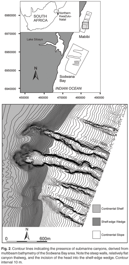
It has long been noted that coelacanth habitats are dependent on both the habitat morphology and the depth of habitation.1–5 This dependence is due to a) the coelacanths' requirement for shelter from predators, b) water temperature-depth constraints which allow for cooler waters required by the coelacanth and c) shelter from direct sunlight. Submarine canyons that indent the continental shelf break and satisfy the morphological and bathymetric constraints on coelacanth habitation are particularly promising habitats for coelacanth exploration. We thus discuss the bathymetric constraints on coelacanth habitation in light of known habitats from the Sodwana Bay submarine canyons, namely caves, overhangs and notches in water depths of ~100 m to 130 m, most often exclusive to heavily-incised canyons that extend beyond the 100-m isobath. Though the Comoros is home to a considerable coelacanth population, coelacanths found in this area do not inhabit submarine canyons, but rather caves formed in the irregular basaltic morphology of the islands.1,3 The east coast of southern Africa provides an alternative habitat in the form of caves and overhangs within the submarine canyons. The relationship between habitat and specific morphological and bathymetric (spatial) criteria thus embraces the use of a geophysical-based GIS for the targeting of new coelacanth habitats along the east coast of South Africa, Mozambique, Tanzania, Kenya, Madagascar and the Comoros. In addition, this GIS would form a framework within which other spatially-dependent data acquired by the African Coelacanth Exploration Programme (ACEP) (i.e. oceanographic and ecological data) could be investigated.
Previous bathymetric studies
Few, if any, geophysical surveys have been conducted along the passive continental margins of the east coast of southern Africa. The majority of offshore geophysical work is limited to South Africa and southern Mozambique.6–8 Mozambique's geophysical data set has been collected primarily for hydrocarbon exploration purposes and has traditionally targeted depths beyond the continental shelf and slope. As such, little geophysical data concerning the shelf and continental slope exist. With respect to Tanzania and Madagascar, there is a complete lack of accessible bathymetric data. In these areas, admiralty charts used for navigation provide the most reliable and comprehensive bathymetric data set.
Methods
The extent of the coelacanth distribution in the western Indian Ocean covers a considerable area, making the search for further elusive coelacanth populations a daunting task. The area of interest extends northwards along the eastern coast of South Africa from East London to Mozambique and Tanzania—as far north as the Tanzanian–Kenyan border, and the entire coastline of Madagascar (Fig. 1).
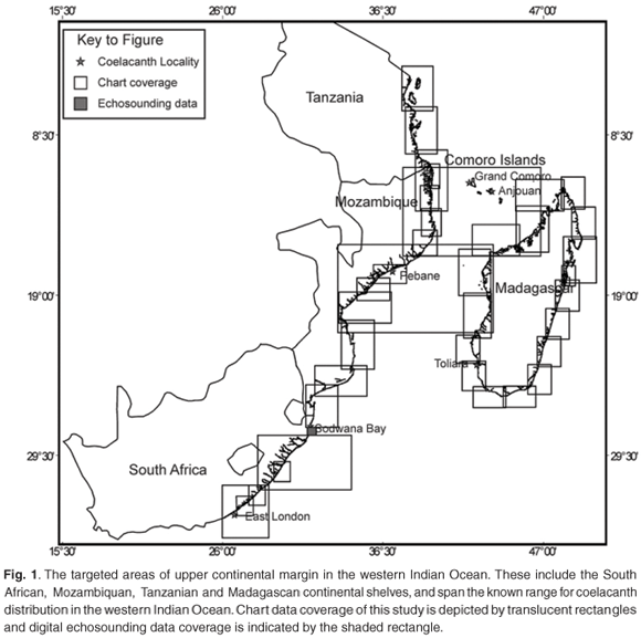
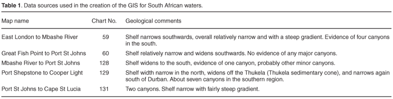
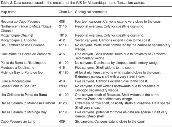
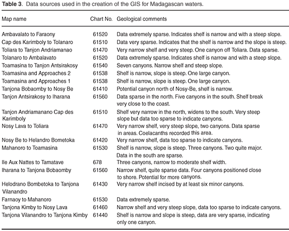
Initially, the collation of all existing hydrographic data for the study area was undertaken. This included archived bathymetric data acquired by the Marine Geoscience Unit of the Council for Geoscience (formerly the South African Geological Survey) as part of a statutory mapping programme of the continental shelf. These data are limited to the shallow continental margin (Fig. 1), and comprise single frequency data acquired by either an Odom Echotrac Model 3100 echosounder operating at 200 kHz frequency, or a Reson Navisound 2111 echosounder with an operating frequency of 210 kHz. In addition to digital bathymetry, five hydrographic charts were used for the South African east coast to supplement the areas not covered by pre-existing digital data. To complete the data set, a further 30 charts for Mozambique, two charts for Tanzania and 21 charts for Madagascar were used (Fig. 1). These data sources are listed in the online supplement to this article (Supplementary Tables 1–3). Problems arose in that older charts had inherent positioning inaccuracies, and many were projected from obsolete or mismatching spheroids, making mosaics of the bathymetric data difficult. To counter this, all paper charts were scanned on an A0 scanner and the digital images polynomially rectified and re-projected to decimal degrees on the WGS 84 Spheroid using ER Mapper 6.3. This allowed the chart contours to be digitised as vector data and incorporated into the GIS, together with coastline data and geological information. The final digitised products were exported as ESRI shapefiles and finalised as a keyable GIS project in ArcView 3.2. Areas of particular interest were identified:
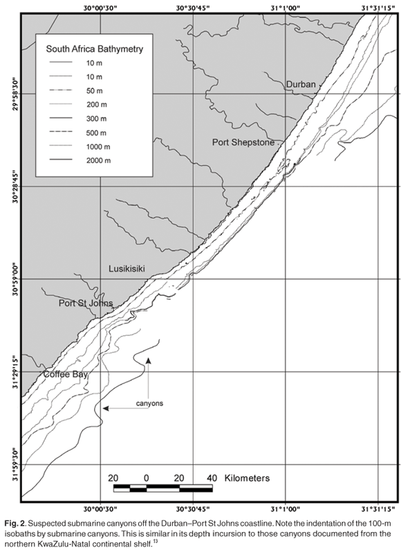
1)Contour lines were arranged in such a way as to either indicate the presence of a submarine canyon (Fig. 2), or steep shelf break and slope relief, analogous to the physical habitat of the Grand Comoros coelacanth.3
2)The canyon heads indent the shelf break (~100 m) and in so doing satisfy the known depth criteria for canyon-specific coelacanths, such as those of Sodwana Bay (Fig. 2).9
Owing to the issue of chart scale and resolution, a certain amount of bias is directed towards canyons that are large enough to be identified from the chart data. Based on previous work,10–12 smaller slope-confined canyons coexist with these larger features, the smaller canyons acting as localised conduits for sediment gravity flows that are actively eroding and thus evolving into larger shelf-indenting features. This study does not preclude smaller canyons as target sites, but rather targets broad areas associated with large canyon systems (and most likely including slope-confined canyons undetectable due to the data resolution) that may prove fruitful for further detailed investigation as outlined by others.13 It is still most likely that large canyons, where the canyon heads extend beyond the 100-m isobath, would possess cave features suitable for habitation, as these caves are considered to have formed during the Last Glacial Maximum (18 000 BP) when sea levels were at 125 m.14
Results
Image geo-referencing accuracy of within a 100-m root mean square error was achieved using the above methods. The resolution of the South African and Mozambiquan data sets were found to be sufficiently dense to identify some of the major canyons similar, and in many instances, greater in size to the Sodwana canyons that most recently yielded coelacanth discoveries. The Tanzanian and Madagascan data are, however, sparser and canyons of similar size to the Sodwana canyons are only identifiable in isolated areas of better data coverage.
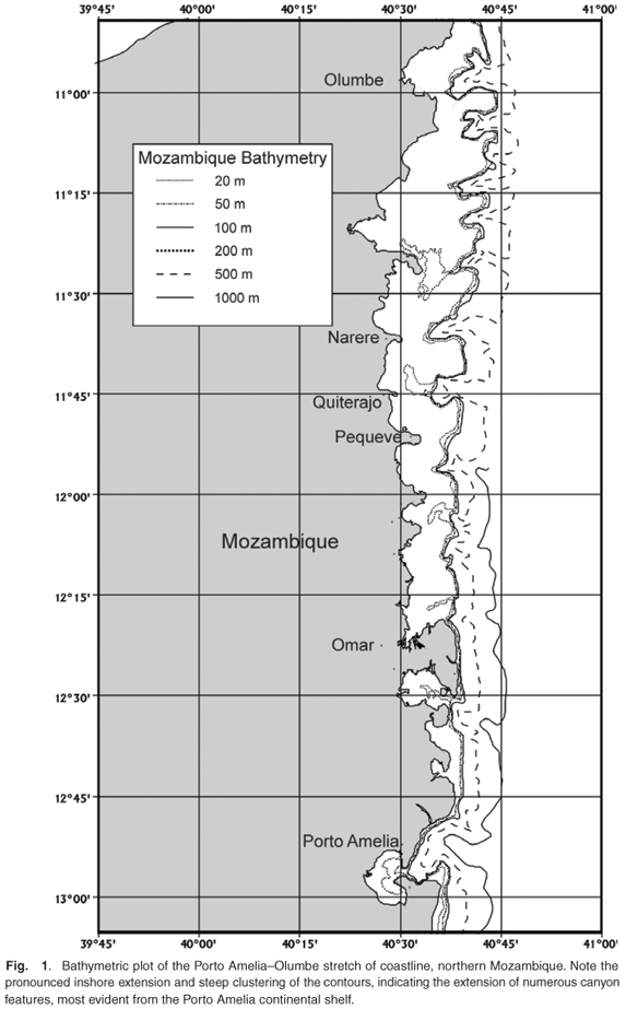
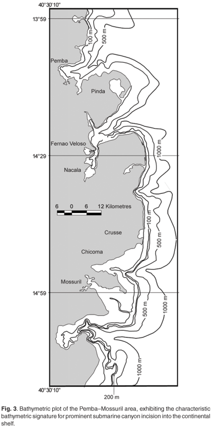
An analysis of the southeast African continental shelf and slope shows great variation in the presence and abundance of submarine canyons. The highest density of submarine canyons occurs between Olumbe and Porto Amelia in northern Mozambique, a distance of 222 km (Supplementary Fig. 1). Other localised areas in Mozambique, which have good submarine canyon development, include Pemba, Nacala, Mossuril and Vilanculos (Fig. 3). Additional well-developed canyons on the South African east coast shelf, between Port Shepstone and Port St Johns, are indicated in the bathymetric data set (Supplementary Fig. 2). These canyons indent the shelf to the 100-m isobath and good cave development in the canyon head is expected, based on the regional geological setting. Sea-level notching during lowstand episodes and the susceptibility of carbonate-rich sand stones to cave development during these periods would provide environmental conditions similar to those found in Jesser Canyon,14 where the most abundant South African coelacanth populations have been documented.
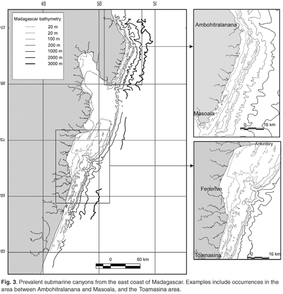
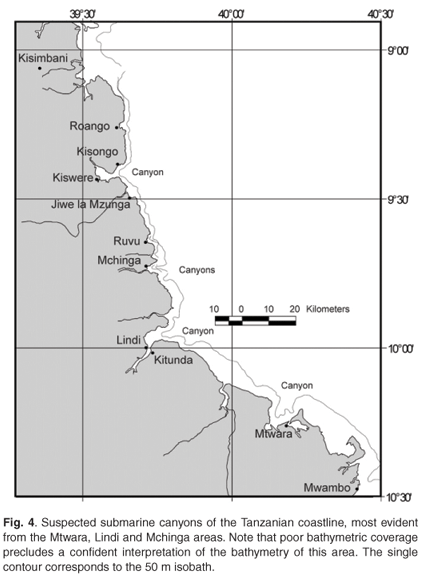
The poor quality of available bathymetric data for Tanzania and Madagascar make defining areas of submarine canyon prevalence quite difficult. Submarine canyons seem to be less well developed in Tanzania, compared to Mozambique, with the best Tanzanian examples occurring offshore of Mtwara, Lindi and Mchinga (Fig. 4). On the west coast shelf of Madagascar, submarine canyons occur at Toliara (where a coelacanth was found) and to the north of Morondava (Fig. 5). Submarine canyons are more prevalent on the Madagascan east coast with examples occurring at Antsiranana and Ankerika, between Ambohitralanana and Masoala and between Fenerive and Ankirihiry (north of Toamasina) (Supplementary Fig. 3).

Discussion
The highest density of submarine canyons and most likely habitat area is the outer shelf area between Olumbe and Porto Amelia in northern Mozambique, only 280 km west of Grand Comoros, which supports the only known substantial coelacanth population.3 Submarine canyons between Port Shepstone and Port St Johns are also considered to be likely target sites, as the oceanographic conditions of the areas appear suitable for habitation (M. Roberts, pers. comm.).
This data set provides a useful 'best guess' approach to identifying and then investigating potential coelacanth habitats based purely on the bathymetric constraints of habitat, as encountered in Sodwana Bay and the Grand Comoros.1 As such it is a useful guide to establishing areas where coelacanth habitation occurs, but other parameters, such as temperature and dissolved oxygen content, must also be considered. Furthermore this study has significant value in providing a basal layer for any other GIS projects that are to be developed by ACEP. Where areas of submarine canyon formation have been coarsely targeted by this project, higher resolution geophysical data acquired by multibeam echosounding should then be undertaken and this information reinvested into the GIS, thus constantly updating the system. Thus GIS has the potential to be constantly updated and supplied with new scientific knowledge, broadening not only knowledge concerning potential coelacanth habitats, but also other knowledge of those areas based on biological and oceanographic data.
Conclusion
Specific target sites for coelacanth habitation using geophysical data have been identified for the continental shelf off the Port Shepstone–Port St Johns stretch of coastline. Northern Mozambique, between Olumbe and Port Amelia, is considered another potential target site, based on the similarity of the submarine canyons to those of Sodwana Bay. Canyon size, depth of incision and the position of the canyon heads, relative to the shelf break, mirror those of the Sodwana Bay canyons. As this is a preliminary study it is recommended that higher resolution multibeam echosounding be undertaken in these areas in order to more accurately identify the features considered most likely to support a coelacanth population. These would be based on the presence of caves, overhangs and notches that coelacanths are known to inhabit. It must also be emphasised that despite poor coverage of areas such as Tanzania and Madagascar, these should not be excluded as potential sites for further, more detailed exploration.
1. Fricke H. and Plante R. (1988). Habitat requirements of the living coelacanth Latimeria chalumnae at Grande Comore, Indian Ocean. Naturwissenschaften 15, 149–151. [ Links ]
2. Bruton M.N. and Stobbs R.E. (1991). The ecology and conservation of the coelacanth Latimeria chalumnae. Environ. Biol. Fishes 32, 313–339. [ Links ]
3. Fricke H., Hissmann K., Schauer J., Reinicke O., Kasang L. and Plante R. (1991). Habitat and population size of the coelacanth Latimeria chalumnae at Grande Comoro. Environ. Biol. Fishes 32, 287–300. [ Links ]
4. Fricke H. and Hissmann K. (1994). Home range and migrations of the living coelacanth Latimeria chlaumnae. Mar. Biol. 120, 171–180. [ Links ]
5. Fricke H., Hissmann K., Schauer J., Erdmann M., Moosa M.K. and Plante R. (2000). Biogeography of the Indonesian coelacanths. Nature 403, 38. [ Links ]
6. Kolla V., Eittreim S., Sullivan L., Kostecki J.A. and Burckle L.H. (1980). Current-controlled microtopography and sedimentation in Mozambique basin, Southwest Indian Ocean. Mar. Geol. 34, 171–206. [ Links ]
7. Martin A.K. (1984). Plate tectonic status and sedimentary basin infill of the Natal Valley (SW Indian Ocean). Bulletin Joint Geological Survey/University of Cape Town Marine Geoscience Unit 14, 208. [ Links ]
8. Salman G. and Abdulla I. (1996). Development of the Mozambique and Ruvuma sedimentary basins, offshore Mozambique. Sed. Geol. 96, 7–41. [ Links ]
9. Hissmann K., Fricke H., Schauer J., Ribbink A.J., Roberts M., Sink K. and Heemstra P. (2006). The South African coelacanths – an account of what is known after three submersible expeditions. S. Afr. J. Sci. 102, 491–501. [ Links ]
10. Farre J.A., McGregor B.A., Ryan W.B.F. and Robb J.M. (1983). Breaching the shelfbreak; passage from youthful to mature phase in submarine canyon evolution. In The Shelfbreak: Critical Interface on Continental Margins, vol. 33, eds D.J Stanley and G.T. Moore, pp. 25–39. Society of Economic Palaeontologists and Mineralogists, Tulsa. [ Links ]
11. Pratson L.F. and Coakley B.J. (1996). A model for the headward erosion of submarine canyons induced by downslope-eroding sediment flows. Geol. Soc. Am. Bull. 108, 225–234. [ Links ]
12. Green A.N., Goff J.A. and Uken R. (2007). Geomorphological evidence for upslope canyon-forming processes on the northern KwaZulu-Natal shelf, South Africa. GeoMar. Lett. 27, 399–409. [ Links ]
13. Ramsay P.J. and Miller W.R. (2006). Marine geophysical technology used to define coelacanth habitats. S. Afr. J. Sci. 102, 427–435. [ Links ]
14. Green A.N. and Uken R. (2005). First observations of sea-level indicators related to glacial maxima at Sodwana Bay, northern KwaZulu-Natal. S. Afr. J. Sci. 101, 236–238. [ Links ]
Received 24 January 2008. Accepted 29 April 2009.
This article is accompanied by supplementary material online at www.sajs.co.za
* Author for correspondence E-mail: greena1@ukzn.ac.za
Green A., Uken R., Ramsay P., Leuci R. and Perritt S. (2009). Potential sites for suitable coelacanth habitat using bathymetric data from the western Indian Ocean. S. Afr. J. Sci. 105, 151–154.