


Services on Demand
Article
 English (pdf)
 Article in xml format
 Article references
Indicators

Related links
-
 Cited by Google
 -
 Similars in Google
Share

 Permalink
South African Journal of Science
On-line version ISSN 1996-7489
Print version ISSN 0038-2353
S. Afr. j. sci. vol.105 n.1-2 Pretoria Jan./Feb. 2009
REVIEW ARTICLES
Water resources in the Klein Karoo: the challenge of sustainable development in a water-scarce area
David Le Maitre*; Christine Colvin; Ashton Maherry
CSIR Natural Resources and the Environment, P.O. Box 320, Stellenbosch 7600, South Africa
ABSTRACT
The Klein Karoo is situated in the Western Cape, South Africa, and is characterised by low rainfall (100–450 mm yr–1). The Klein Karoo is situated in the primary catchment of the Gouritz River. The mean annual runoff (MAR) for the three major tributaries of the Gouritz River arising in or feeding the Klein Karoo (Touws, Gamka, Olifants) is 540 Mm3 yr–1. Groundwater recharge in the three Klein Karoo catchments is ±257 Mm3 yr–1, but only a portion of this reaches the rivers. The very variable flows result in low 1:50 year yield of 161 Mm3 (30% of MAR). The current demand for water in these catchments is 182 Mm3 yr–1, which exceeds the yield, and demand is projected to increase between 23% and 150% by 2025. Changes in the approach to water management are required, including improving the efficiency of irrigation and land restoration to improve water infiltration and reduce soil erosion. We believe that it is time to change to a water management approach that is designed to anticipate and manage the inherent variability in water resources in the Klein Karoo, thereby placing the region on a path to sustainable development.
Key words: water resource management, surface water, ground-water, variability, water demand, land management, sustainable development
Introduction
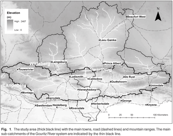
The Klein Karoo is an ecologically and economically diverse region of South Africa situated in a broad east–west oriented valley between the relatively well-watered Langeberg-Outeniqua Mountains in the south and the Witteberg-Swartberg Mountains in the north (Fig. 1). It lies within the Gouritz River system whose tributaries extend through the Swartberg Mountains into the Great Karoo. Three biomes meet in the Klein Karoo:1,2 Fynbos, Succulent Karoo and Thicket. Both Fynbos and Succulent Karoo are recognised as global biodiversity hotspots3 with a variety of plant species. The perennial reaches of the Gouritz River system are also important for the conservation of aquatic biodiversity, including a number of threatened fish species.3,4 A history of poor management has left much of the Klein Karoo degraded by over-grazing and poor cultivation practices.5 The riverine areas are the worst affected, with only 11% in a near natural state, almost all of which is in source areas which are too steep to cultivate and provide poor forage.5 Extensive land degradation has already altered the hydrology and geohydrology of the Klein Karoo and its aquatic and groundwater-dependent ecosystems.6,7 Vegetation loss and trampling by livestock have altered key processes such as water infiltration, increasing soil erosion and changing river flow regimes.
The Klein Karoo is a semi-arid to arid area and fresh water is a critical constraint to future economic development. Although water is widely recognised as a critical constraint, there is a dearth of information on the state of the water resources in the Klein Karoo. This paper reviews information on the water resources of the Klein Karoo, covering both groundwater and surface water, and highlights some of the key issues, knowledge gaps and future options. Recent overviews include the Water Situation Assessment8 and internal strategic perspective prepared for the Gouritz Water Management Area (WMA),9 which includes the catchments of some of the adjacent coastal river systems.
Study area
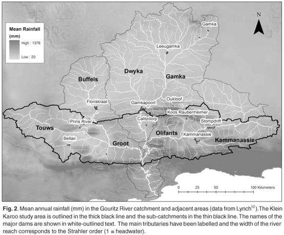
There are different definitions of the extent of the Klein Karoo, depending largely on whether the boundaries are defined geographically, biogeographically or hydrologically. This study uses hydrological boundaries based on the boundary of the catchment of the Gouritz River system,10 which falls within or overlaps the geographical boundaries of the Klein Karoo used by Vlok et al.1 Much of the water used in the Klein Karoo is sourced from catchments which are situated to the north of the Witteberg-Swartberg Mountain Ranges, including their northern slopes, so these catchments are included as well (Fig. 1). The exceptions are the catchments of the Kingna River (Montagu area) and the Tradouw River (Barrydale area), which are tributaries of the Breede River system. Detailed data on water use and demand for these specific systems are lacking so they are not dealt with in this paper. The focus of this study is on the major sub-catchments of the Gouritz River system within or supplying the Klein Karoo (Fig. 2): the Touws, Buffels and Groot Rivers (secondary J1); Dwyka and Gamka (J2) and the Olifants and Kammanassie Rivers (J3). The final sub-catchment is the Gouritz River itself, which is the secondary catchment J4, called the lower Gouritz in this analysis to distinguish it from the whole Gouritz River system (J). The WMA also includes the catchments of the Duiwenhoks River (H8), Goukou (H9) and the coastal catchments from the Klein and Groot Brak Rivers (K1) to the Keurbooms River (K6).
Data sources and methods
The primary sources of climatic data were the climate atlas11 and mean annual rainfall from Lynch.12 Additional climatic data for specific localities were obtained from the South African Weather Bureau13 and Wentzel.14 Hydrological data for surface water per quaternary (4th order) catchment and naturalised flows at dams and weirs were taken from Midgley et al.10 Data on river baseflows were taken from statistics calculated using the SPATSIM modelling framework software.15
Information on water use and demand was obtained from the South African Department of Water Affairs and Forestry overviews,8,9 supplemented with information from the Water Authorisation Registration and Management System (WARMS) database. A total of 8 325 registered water use points were obtained8,9 for the Klein Karoo, of which 93% fell within the study area and were used. The data have been provisionally reviewed, but because the information must still be verified, only comparative analyses are presented.
Data on groundwater recharge and contribution to baseflows were obtained from the Groundwater Resource Assessment (GRA).16 Groundwater quality data for boreholes in the study area were extracted from the WARMS database. The database contains a number of zero values in the case where only minor ions were analysed. In order to compensate for this, the zero values were deleted prior to calculating any statistics. This resulted in a total of 3 141 data entries. Where there was a time-series for the borehole, the values were treated as individual data entries. The WARMS database provides latitude and longitude data for borehole localities, which were used to allocate them to quaternary catchments and to principal aquifer types based on a 1:1 million scale geological map.17,18
Groundwater recharge was calculated using the GRA16 values of recharge per quaternary catchment and was spatially joined with the aquifer types to calculate the volume per polygon. The layer was then cropped to the Klein Karoo study area boundary, and the area values recalculated. A Microsoft® Excel 2003 pivot table was used to summarise the data. Average recharge (mm) per aquifer type was calculated by dividing the volume by the area of the aquifer.
Biophysical environment: climate and water resources
Climate
Rainfall
The Klein Karoo is characterised by marked orographic rainfall gradients and rain shadow effects. The upper slopes of the Langeberg-Outeniqua Mountain Ranges receive up to 1 650 mm and the Witteberg-Swartberg more than 1 000 mm but most of the low-lying central valley receives 100–300 mm per year (Fig. 2). The driest areas are in the west where some parts get only 50–100 mm. The seasonal distribution of the rainfall varies from winter-dominant in the far west (Montagu, Fig. 3), to bimodal (Ladismith), to summer in the east (Willowmore). The winter rains are brought by cold fronts associated with low-pressure systems and westerly winds.19,20 Summer rainfall is dominated by moisture from the east and convective systems which are less affected by orographic gradients. The rainfall regime is also characterised by extremely high rainfall events, associated with cut-off low pressure systems,20 which can result in major floods: e.g. Laingsburg to Montagu in January 1981, Montagu in March 2003 and Zoar in 2004.
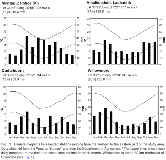
The variability in the rainfall increases as the rainfall decreases. In areas with <300 mm per year, the coefficient of variation is 36–40% compared with 15–20% in the high rainfall areas.20 Areas receiving winter rainfall have more reliable rainfall than those receiving summer rainfall, and the difference increases as the mean annual rainfall increases.20,21 The Klein Karoo has a quasi 10–12 year cycle: roughly five years with more and five years with less rainfall and a range of 10–30% either side of the long-term mean.19,22
Temperature and evaporation
The mean daily temperature in February is >30°C in the lowlands and in the upper 20s in the mountain areas and the coastal side of the Klein Karoo11. In August the corresponding temperatures are 20–22°C and 12–14°C. The corresponding mean daily minima for January are 14–16°C and 10–12°C and for August 4–8°C and –2–2°C.
The area receives more than 80% of the potential solar radiation throughout the year,23 resulting in high evaporation rates. The potential evaporation (PEt, A-pan equivalents11) is more than 2 000 mm per year and exceeds 2 250 mm per year (>10 times the rainfall) in the dry central region. There is an east–west gradient in the seasonal distribution where the ratio of the January to June PEt ranges from more than five in the west to three in the east, emphasising the greater seasonality in the west.
Surface water resources
Mean annual runoff
The Gouritz River system (catchment J) was estimated to have a mean annual runoff (MAR) of about 674 Mm3 (ref 10) although the most recent study9 gives 562 Mm3. Most of the surface runoff statistics were obtained from Midgley et al.10 so we have used the data from their study unless otherwise indicated. The MAR is equivalent to 12.5 mm or about 5.7% of the mean annual rainfall, substantially lower than the mean for South Africa of about 9.0%,10 but similar to arid parts of Australia.24,25
Spatial variation in surface runoff
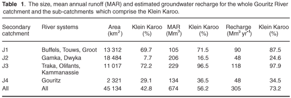
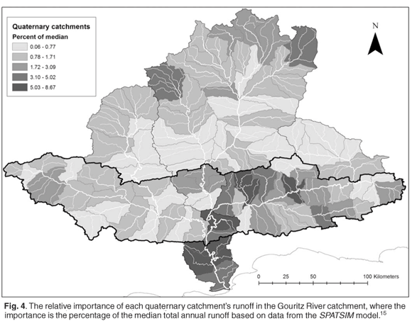
The Gouritz River system has been divided into four main sub-catchments (Table 1). More than 90% of the Olifants and Kammanassie sub-catchment (J3, Fig. 2) lies to the north of the Swartberg, within the Great Karoo, but the flows supply the Gamkapoort Dam which supports irrigation in the Klein Karoo. The sub-catchments of the Dwyka and Gamka (J2) and the Olifants (J3) fall mainly within the Karoo, but sub-catchment J4 (lower Gouritz) is situated mainly south of the Outeniqua Mountains (Fig. 2). Although catchments in the Klein Karoo comprise only 43% of the Gouritz River system, they produce most (56%) of the runoff (Fig. 4) and capture more than 70% of the estimated recharge (Table 1) because they include a large proportion of the TMG aquifer.
Surface water flow variability
The volumes of runoff are not only low, they are also very variable, with the coefficient of variation (CV) for streamflow being 2–5 times the CV of rainfall, as found in other arid areas.24,25 Analyses of the naturalised runoff records in Midgley et al.10 show that the quaternary MAR varies between 1.1 and 2.8 times the median annual runoff.7 The CV ranges from 0.7–1.7 times the MAR and decreases as the amount of runoff increases. The drier catchments have a high percentage of zero flow months, some more than 25%. The high runoff in wet years or during floods is reflected in the maximum annual runoff being 2–12 times the MAR and the minimum 0–0.3 times.7
Multi-year trends in mean annual runoff
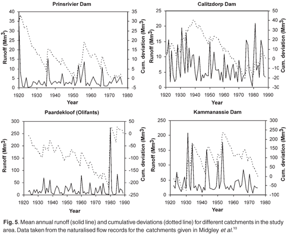
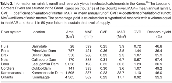
Analysis of the naturalised runoff and cumulative deviations from the mean volumes of naturalised runoff, measured at dams and weirs, highlight the spatial variability of the flows.7 Each of the records that was analysed had unique features (Fig. 5). Most of the flows have extended periods of below-average runoff, e.g. the Prins River from 1922–1936 and Calitzdorp Dam from 1940–1974. The high runoff measured in the Prins River in 1920 plays a dominant role in the pattern of deviations, as does the massive volume of runoff at Paardekloof (Olifants River) in 1980. If these exceptional values are replaced with the mean for those series, the cumulative deviations are negative for the Prins River until 1956; Paardekloof has a negative cumulative deviation until 1938 and then is positive until 1978, reasonably similar to the Kammanassie Dam.7 The high variability of the flows and the long-term deviations result in low reservoir yields (based on a 1 in 50-year failure probability), even from a reservoir with a capacity equal to the MAR (Table 2).25,26
Surface water quality
Much of the groundwater in the Klein Karoo is saline because the geological formations which form most of the aquifers give rise to naturally saline groundwater (e.g. the Enon conglomerate near Oudtshoorn)8 combined with high evaporation rates. This makes the water naturally poor quality for agricultural purposes. Natural salinity also affects the river systems draining the Great Karoo and has been increased by the return flows from the irrigated lands in the Touws, Buffels and Groot River catchments. The water quality is generally acceptable in the upper catchments, except for the Buffels River upstream of the Floriskraal Dam, and declines downstream–becoming unacceptable in the Groot River (J13).8 The water quality is unacceptable in the lower reaches of the Olifants River, largely due to the return flows from irrigated areas. No data are available for the main stem of the lower Gouritz River (J4) but the quality reaching the estuary is likely to be poor despite dilution by the better-quality water from the sub-catchments on the southern slopes of the Outeniqua Mountains.
Groundwater resources
Aquifer types
Groundwater in the Klein Karoo is stored in three types of aquifers. Primary aquifers are formed from unconsolidated sediments which have been deposited primarily as alluvium in the floodplains of the major river systems; these aquifers typically occur in low-rainfall areas and are mainly recharged during high flows and floods during the wet season. Secondary karstic aquifers are very limited in extent as they are only found in the carbonates of the Kango formation; dissolution fissures can store large volumes of water which flows relatively rapidly through them and results in springs and boreholes with high yields. Secondary fractured aquifers are the most widespread and extensive type in the Klein Karoo, including the Table Mountain Group (TMG) quartzites, Witteberg sandstones and the Bokkeveld shales. The water is stored in and flows through the fractures and fault systems; open fractures can store relatively large volumes of water but they represent only a small fraction of the total rock volume.
Recharge
The quartzitic sandstones of the TMG and, to a lesser extent, Witteberg, form the bulk of the mountains and the relatively high rainfall they receive results in high recharge: about 10% or >50 mm per year. The estimated recharge derived for the GRA study16 is 305 Mm3 yr–1 for the whole Gouritz River system and 257 Mm3 yr–1 for the three main tributaries. This is equivalent to about 48% of the MAR for the latter catchments and is highest for the Groot River system (J1). A large but unknown proportion of the recharge is lost through transpiration by vegetation in the discharge areas, particularly riparian zones and floodplains which may explain why the base-flow in these catchments is only 95 Mm3 yr–1.
The TMG receives more than 70% of the total groundwater recharge for the entire Klein Karoo. The extensive faulting and fracturing of the TMG results in relatively high deep-groundwater storage in discrete fault zones, and discharge from the TMG aquifers maintains the perennial flows in the main river systems. The groundwater flowpaths may extend for tens of kilometers and reach up to 3 km in depth as shown by the temperatures of the hot springs in the area, for example 50°C at the Calitzdorp hot spring.27
Groundwater yields
The Bokkeveld shales comprise much of the central area of the Klein Karoo and have low recharge (<6 mm per year). Boreholes typically have low yields (<1 l s–1) although the Ceres sub-group has three formations with greater permeability and higher yields (>5 l s–1).27 Yields from boreholes sited on water-bearing structures in the TMG may be higher. The TMG formations continue beneath the Bokkeveld in the synclinal structure known as the Outeniqua basin in the Oudtshoorn area. Estimates of the volumes of groundwater that could be abstracted from this basin, which is at least 1 000 mm thick, range from 58 to 320 Mm3.(ref 28) Ongoing exploration drilling should provide a better estimate of the sustainable yield of the deep aquifer.
Groundwater quality
Only the TMG yields high-quality groundwater for human consumption, with its median total dissolved solids of <260 mg l–1.(ref 29) The groundwater from the Witteberg, Bokkeveld, and the Uitenhage Group, which includes the Kango formation and is found in the Oudtshoorn area, range from 261–600 mg l–1 (good) to 601–1 800 (marginal) to >1 800 (poor to unacceptable) depending on the inherent salinity of the rock formations. In the case of the Kango formation the poor quality is due to high concentrations of carbonates rather than sodium. The groundwater quality is marginal over at least 60% of the study area. The limited data that are available indicate that most of the alluvial aquifers also contain marginal quality groundwater.
Water availability and requirements
Availability
The most comprehensive summary of the current availability and use of water resources is the data compiled for the Water Resource Overview8 and Internal Strategic Perspective.9 Unfortunately these sources use a grouping of sub-catchments where the lower Gouritz sub-catchment (J4) is combined with the coastal catchments.
The 2000 assessment of water availability highlights the limited amounts of water available. The low volumes, combined with the highly variable flows, account for the 1:50 year yields of only 161 Mm3 for the three main tributaries (Groot, Gamka, Olifants) (Table 3), which is only about 29.8% of the mean annual runoff. The impact of the environmental allocation (Ecological Reserve, National Water Act No. 36, 1998) on the availability of water is not seen as being a major issue except for the coastal catchments, where river and estuary requirements have been set at very high levels (Table 3). However, it is important to emphasise that full determinations of the ecological reserve are needed so that the required amounts can be determined with a reasonable degree of confidence.

Current water requirements
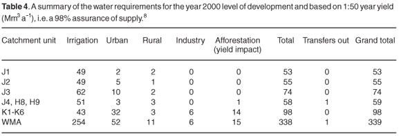
The best available information on the current demand is the recent overview8 (Table 4). The current total requirement for the WMA is 339 Mm3 yr–1, about 30% of which is in the coastal catchments where there is high usage by the irrigation, urban and forestry sectors. The demand in the sub-catchments of the three main tributaries (Groot, Gamka, Olifants) was 182 Mm3 in 2000 at a 98% assurance, with 160 Mm3 for irrigation.8 The majority (73%) of registered water use is for river abstractions, 15% from schemes (including groundwater schemes such as the Klein Karoo Rural Water Supply Scheme), 8% from boreholes, 3% from springs and only 0.6% from dams. The currently available water resources, based on the estimates for 1:50 year yields (Table 3), are not sufficient to meet the requirements (Table 4). The result is that there is a net deficit of 64 Mm3 yr–1 for the WMA, two-thirds of which is in the coastal catchments and the balance in the three main tributaries (Table 5). This means there is already a water deficit, at least in terms of the estimated demand and desired assurance of supply. This is particularly acute in the Touws-Buffels-Groot catchment and can be expected to result in a decrease in the sustainable yield, or a reduction in the assurance of supply that needs to be addressed.

Irrigation
Irrigation currently accounts for 75% of all the water used in the Gouritz WMA and 84–92% of the water used in the three main tributaries. Although these figures must be interpreted with caution because the farmers generally operate with a low assurance of supply (because of the long periods in which there is below-average inflow into the dams), the pressure to retain all flood water in the dams does place a severe stress on the river systems and results in heavily modified flow regimes. In many cases the allocations exceed the available yields. For example, over-allocation within the Olifants River Government Water Scheme has resulted in the combined allocation from the Stompdrift and Kammanassie Dams being 87.7 Mm3 yr–1, which is 266% of their combined 1:50 year yield.8 The high levels of existing demand and use are important because of the drive to establish new irrigation schemes for formerly disadvantaged farmers and develop the resource base of rural communities. Irrigated farming is seen as the only form of agriculture that is currently economically viable and could be used for this purpose.9
Urban
Urban water use for municipalities and industries is generally low in the Klein Karoo catchments, except where there are reasonably large towns such as Calitzdorp (Gamka) and Ladismith (Touws-Groot).8 Oudtshoorn accounts for almost all the 10 Mm3 yr–1 taken from the Olifants River sub-catchment (J3) for urban use. Very limited population growth, or even a decline, is predicted for the Gamka and Touws-Groot catchments, but the population is expected to grow in the Olifants catchment.8 The available data show somewhat different trends; the population of Kannaland (Ladismith) in the Touws catchment increased from 21 105 in 1996 to 23 971 in 2001 (14%) while Oudtshoorn grew from 78 846 to 84 692 (7%).30 Migration of the rural populations to the local urban centres is expected to continue. Population densities are low, with 80% or more of the population residing in the towns.
Groundwater
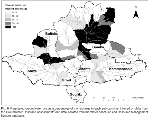
The DWAF studies8,9 used crude estimates of the amount of groundwater available. Since then, the GRA16 study has provided estimates of the available resource based on recharge storage, but more detailed studies are required to determine sustainable yields. Data used in this study indicate that many of the Great Karoo sub-catchments and some of the sub-catchments close to Oudtshoorn are stressed, with more than 50% of recharge being registered for abstraction by users (Fig. 6). There is likely to be an overlap in total available water resources, where groundwater recharge contributes to surface water baseflow. This issue needs to be understood better to avoid over-allocation of groundwater resources in the future, and minimise the potential for significant adverse environmental impacts and clashes of interest between surface and groundwater users.
Impacts of invasive alien plants
The total flow reduction due to invasive alien plants is estimated at 121 Mm3 yr–1 (ref 8) based on the data used for the Water Situation Assessment Model (which originally came from the study by Versfeld et al.31). The impacts on the 1:50 yields from the different sub-catchments are substantial (Table 3), especially in catchments which include the coastal mountain ranges where there are extensive invasions by Hakea species and by various Acacia species along the river systems.31 Clearing of the invaders in the different catchments could help by substantially reducing the existing deficits in the Olifants River system and in the coastal catchments. The impact of alien invasive plants on the 1:50 year yield in the three main tributaries is estimated at 15 Mm3.(ref 9) Large areas of the river bed and floodplain of the Olifants River, and to some extent the other rivers, have also been invaded by Arundo donax (Spaansriet), a species which probably has very high levels of water-use, but its impacts have not been quantified yet.
Impacts of climate change
The lack of information on the implications of climate change for the water resource situation in the Gouritz WMA was identified as an important issue.8,9 Assessments of the implications of climate change for South Africa have been done at a national scale32–34 but none have focused specifically on the Klein Karoo. A recent assessment for the Western Cape Province predicts the following general trends:35 a reduction in winter rainfall; an increase in summer rainfall and rainfall intensity in the east; a monthly rainfall change of 10 mm or more; and an increase in air temperature, particularly the minimum temperature, by up to 2–3°C.
The decrease in winter rainfall will affect the western regions, the southern mountains and the Swartberg. The projected weakening of the cold fronts could be significant if this decreases the probability of them bringing substantial amounts of rain to the inland mountain ranges, which are important for surface water resources in the Klein Karoo (Fig. 2). The increase in air temperatures will substantially increase the evaporative demand, partially or potentially completely offsetting increases in summer rainfall and aggravating decreases in winter rainfall. The volumes of recharge to groundwater and runoff in catchments of the Klein Karoo are likely to decrease substantially, but montane areas may be less affected. The variability of river flows might increase with a tendency to more erratic flows and more frequent floods.
Water requirements in 2025
The projected water balance in 2025 was estimated using two different scenarios, one with limited increase in use and one with a high level of increase9 (Table 5). Both show clearly that the projected trends will lead to increasing deficits. The baseline scenario results in a 23% increase and the high-level scenario nearly 150%. Protection of the ecological integrity of the system (termed the ecological reserve), could be met by the approximately 120 Mm3 yr–1 that would be released by complete clearing of invasive alien plants (see below), but the increases in yields will not be sufficient in most of the catchments and will not be of any use where their impacts are minimal (e.g. the Gamka catchment). About 22 Mm3 yr–1 of the total increase could be made available, at a 1:50 year assurance of supply. The greatest benefits will be in the Olifants River system, where the increase in the 1:50 year yield of 4 Mm3 yr–1 could help alleviate the problems caused by historical over-allocations, especially in the lower parts of the catchment.
Balancing supply and demand
As irrigation is the major water use, particularly in the inland catchments, it is clear that there will have to be a strategy aimed at improving water-use efficiency, which includes reducing the return flows of saline water that are affecting the river systems and downstream users.8 Urban water requirements are not expected to increase substantially and most of the projected increase is expected to be in the coastal catchments rather than in the Klein Karoo. Overall, the increases in efficiency are unlikely to have a significant impact relative to those in the agricultural sector. Rural water requirements are not expected to increase substantially and may even decrease slightly with the trend of increasing movement of people to the urban areas.
The overview report8 recommends that controlled burning of fynbos catchments to reduce the mean age of the fynbos and increase water yields could be investigated further. This intervention is unlikely to result in a substantial increase in water yields, as fynbos typically has a low biomass and relatively low water-use,36,37 and frequent fires could have adverse impacts on the biodiversity functioning of these ecosystems.
Recommendations
The water resource situation in the Klein Karoo is approaching a crisis. The current levels of demand have passed the stage of sustainable use and balancing of human and ecological requirements envisaged by the National Water Act. Water demand is projected to increase significantly by between 23% and 150% by 2025, although there is no way of meeting this demand without even more severely compromising the functioning of the river systems. The impacts of climate change are uncertain, but are likely to result both in a reduction in the available water resources and even greater variability in flow regimes and recharge.
There are various options for mitigating this situation. First, the efficiency of irrigation could be improved by ensuring that the most efficient technologies are used in both water delivery and application to maximise crop yields while minimising the volume of return flows and, thus, the salinisation caused by irrigation. The possibility of changing to crops with a higher water-use efficiency and value should be assessed. Second, although water consumption by urban areas is a small proportion of the overall use, upgrading of urban water service infrastructure to minimise water losses (e.g. leaking water mains) could be beneficial at the local scale as well as reduce the volume of water that needs treatment. Third, making use of managed aquifer storage, including artificial recharge, could reduce water loss through evaporation compared with storage dams.
Even aquifers which have naturally high salinities may be used for the artificial storage of good quality water because mixing rates are quite low.38 The Klein Karoo, with its very high rates of evapotranspiration, is well suited to subsurface storage of water in aquifers, particularly in alluvial aquifers, the TMG and the Kango carbonates.
Research is needed to get a better understanding of the dynamics of the groundwater resource, particularly recharge, and its sustainable yield in different parts of the Gouritz WMA.8 This includes research into the potential use of groundwater from the TMG aquifer, particularly the deep groundwater. Research into the potential environmental consequences of large-scale abstraction needs to be given a high priority. Implementing alien vegetation control, particularly in the rivers on the northern slopes of the Outeniqua Mountains and foothills of the Swartberg, could further alleviate the situation. Lastly, effective land-care programmes could explore the synergies between improving water infiltration; reducing soil erosion and vegetation or crop productivity at small scales; and decreasing sediment loads and increasing sustainable yields at the scale of water supply schemes.
The mitigation measures outlined above are necessary and beneficial, but they are not sufficient. The current approach to water resource management has been designed to maximise human exploitation of the water resources of the Klein Karoo. Floods, droughts and water shortages have been seen as abnormal events rather than as normal and inherent in the system. The same inflexible approach to natural resource management has been applied to other land resources (e.g. natural grazing) and the net result has been severe land degradation. We believe that only a fundamental re-appraisal of land-use patterns could place the Klein Karoo on a path to sustainable development.39,40 A partial solution could be the 'soft path'approach to water management,41 which emphasises the need to move away from hard engineering technology to community-scale resource management wherever feasible; decentralised and open decision-making; equitable pricing; increasing efficiency of water-use (both in volumetric and economic terms); and implementing strong environmental protection measures. These changes may entail shifts in both social and economic systems which will affect everyone involved in the Klein Karoo in some way or other.
This work was supported by parliamentary grant funding received by the CSIR. We thank the Department of Water Affairs for access to data from the Water Allocation and Resource Management System and National Groundwater Database on water allocations and water quality. We also thank our colleagues for useful discussions as well as the Klein Karoo Study Group, Gouritz Initiative and Arid Zone Forum for encouragement to pursue this work.
1. Vlok J., Cowling R. and Wolf T. (2005). A vegetation map for the Klein Karoo. Unpublished maps and report for a SKEP project supported by the Critical Ecosystem Partnership Fund, Grant No. 1064410304, Cape Town, South Africa. Online at: http://bgis.sanbi.org/littlekaroo/index.asp [ Links ]
2. Mucina L. and Rutherford M.C., eds (2006). The Vegetation of South Africa, Lesotho and Swaziland, Strelitzia 19. South African National Biodiversity Institute, Pretoria. [ Links ]
3. Driver A., Desmet P., Rouget M., Cowling R. and Maze K. (2003). Succulent Karoo Ecosystem Plan. Biodiversity Component Technical Report, Cape Conservation Unit Report No. CCU 1/03. Botanical Society of South Africa, Kirstenbosch, Cape Town. [ Links ]
4. Lombaard and Wolf CC (2004). GIS specialist services. Gouritz Initiative Final Report. Western Cape Nature Conservation, George. [ Links ]
5. Thompson M.W., Vlok J., Cowling R.M., Cundill S.L. and Mudau, N. (2005). A land transformation map for the Little Karoo. Final Report Version 2. Critical Ecosystems Protection Fund, CAPE, Cape Town. [ Links ]
6. Cleaver G., Brown L.R., Bredenkamp G.J., Smart M.C. and Rautenbach C.J. de W. (2003). Assessment of environmental impacts of groundwater abstraction from Table Mountain Group (TMG) aquifers on ecosystems in the Kammanassie Nature Reserve and environs. Report No. 1115/1/03. Water Research Commission, Pretoria. [ Links ]
7. Le Maitre D., Maherry A., Colvin C., Prinsloo E., Hughes S., Smith-Adao L. and Saayman I. (2007). An overview of the hydrology, geohydrology and water resources of the Klein Karoo. Report No. CSIR/NRE/ECO/IR/2007/0010/A. CSIR Natural Resources and the Environment, Stellenbosch. [ Links ]
8. DWAF (2003). Overview of water resources availability and utilisation. Gouritz Water Management Area Report P WMA 16/000/00/0203. Department of Water Affairs and Forestry, Pretoria. [ Links ]
9. DWAF (2004). Internal strategic perspective. Version 1. Gouritz Water Management Area Report P WMA 16/000/00/0304. Department of Water Affairs and Forestry, Pretoria. [ Links ]
10. Midgley D.C., Pitman W.V. and Middleton B.J. (1994). The surface water resources of South Africa 1990, vols 1 to 6. Report Nos 298/1.1/94 to 298/6.1/94 (text) and 298/1.2/94 to 298/6.2/94 (maps). Water Research Commission, Pretoria. [ Links ]
11. Schulze R.E., Maharaj M., Lynch S.D., Howe B.J. and Melvil-Thompson B. (1997). South African atlas of agrohydrology and climatology. Report No. TT82/96. Water Research Commission, Pretoria. [ Links ]
12. Lynch S.D. (2004). Development of a raster database of annual, monthly and daily rainfall for southern Africa. Report No. 1156/1/04. Water Research Commission, Pretoria. [ Links ]
13. SAWB (1998). Climate of South Africa. Climate Statistics up to 1990, WB42. South African Weather Bureau, Department of Environmental Affairs, Pretoria. [ Links ]
14. Wentzel R. (2005). Summary of climatic data for the Agricultural Experimental Farms associated with the Little Karoo. AgroMet-ISCW, Stellenbosch. [ Links ]
15. Hughes D.A., ed. (2005). SPATSIM, an integrated framework for ecological reserve determination and implementation. Report No. TT 245/04. Water Research Commission, Pretoria. [ Links ]
16. DWAF (2005). Groundwater Resource Assessment, Phase II: Methodology. Groundwater-surface water interactions. Department of Water Affairs and Forestry, Pretoria. [ Links ]
17. Council for Geoscience (1997). 1:1 000 000 scale geological map of the Republic of South Africa and the Kingdoms of Lesotho and Swaziland. Council for Geoscience, Pretoria. [ Links ]
18. Colvin C., Le Maitre D. and Hughes S. (2003). Assessing terrestrial groundwater dependent ecosystems in South Africa. Report No. 1090-2/2/03. Water Research Commission, Pretoria. [ Links ]
19. Tyson P.D. (1986). Climatic Change and Variability in Southern Africa. Oxford University Press, Cape Town. [ Links ]
20. Desmet P.G. and Cowling R.M. (1999). The climate of the karoo – a functional approach, In The Karoo – Ecological Patterns and Processes, eds W.R.J. Dean and S.J. Milton, pp. 3–16. Cambridge University Press, Cambridge. [ Links ]
21. Milton S.J., Yeaton R.I., Dean W.R.J. and Vlok J.H.J. (1997). Succulent Karoo, In Vegetation of Southern Africa, eds R.M. Cowling, S.M. Pierce and D.M. Richardson, pp. 131–166. Cambridge University Press, Cambridge. [ Links ]
22. Palmer A.R., Hobson C.G. and Hoffman M.T. (1990). Vegetation change in a semi-arid succulent dwarf shrubland in the eastern Cape, South Africa. S. Afr. J. Sci. 86, 392–395. [ Links ]
23. Schulze R.E. and McGee O.S. (1978). Climatic indices and classifications in relation to the biogeography of southern Africa, In Biogeography and Ecology of Southern Africa, ed. M.J.A. Werger, pp. 19–52. W. Junk, The Hague. [ Links ]
24. McMahon T.A. (1979). Hydrological characteristics of arid zones, In Symposium on the Hydrology of Areas with Low Precipitation, Canberra 1979, Publication No. 128, pp. 105–123. International Association of Hydrological Sciences, Wallingford. [ Links ]
25. Görgens A.H.M. and Hughes D.A. (1982). Synthesis of streamflow information relating to the semi-arid Karoo biome of South Africa. S. Afr. J. Sci. 78, 58–68. [ Links ]
26. Braune E. and Wessels H.P.P. (1980). Effects of land-use on runoff from catchments and yield of present and future storage, Workshop on the effects of rural land-use and catchment management on water resources. CSIR, Pretoria. [ Links ]
27. Meyer P.S. (1999). An explanation of the 1:500 000 general hydrogeological map Oudtshoorn 3320. Department of Water Affairs and Forestry, Pretoria. [ Links ]
28. Umvoto Africa (Pty) Ltd. (2005). Deep artesian groundwater for Oudtshoorn municipal supply, Phase D: target generation and borehole/Wellfield siting using structural geology and geophysical methods (DAGEOS Project). Report No. 1254/1/05. Water Research Commission, Pretoria. [ Links ]
29. DWAF (1996). South African Water Quality Guidelines. In Domestic Water Use, vol. 1, 2nd edn. Department of Water Affairs and Forestry, Pretoria. [ Links ]
30. Eden Municipality (2005). Final Draft Revised Integrated Development Plan 2005/2006. Eden District Municipality, George. [ Links ]
31. Versfeld D.B., Le Maitre D.C. and Chapman R.A. (1998). Alien invading plants and water resources in South Africa: a preliminary assessment. Report No. TT99/98. Water Research Commission, Pretoria. [ Links ]
32. Rutherford M.C., Midgley G.F., Bond W.J., Musil C.F., Powrie L.W., Roberts R. and Allsopp J. (2000). Plant Biodiversity: Vulnerability and Adaptation Assessment. Department of Environmental Affairs and Tourism, Pretoria. [ Links ]
33. Schulze R.E. and Perks L.A. (2000). Assessment of the Impact of Climate. School of Bioresources Engineering and Environmental Hydrology, University of Natal, Pietermaritzburg. [ Links ]
34. Scholes R.J. and Biggs R. (2004). Ecosystem Services in Southern Africa: A Regional Assessment. Council for Scientific and Industrial Research, Pretoria. [ Links ]
35. Midgley G.F., Chapman R.A., Hewitson B., Johnston P., De Wit M., Ziervogel G., Mukheibir P., Van Niekerk L., Tadoss M., Van Wilgen B.W., Kgope B., Morant P.D., Theron A., Scholes R.J. and Forsyth G.G. (2005). A Status Quo, Vulnerability and Adaptation Assessment of the Physical and Socio-economic Effects of Climate Change in the Western Cape. CSIR Environmentek, Stellenbosch. [ Links ]
36. Bosch J.M., Van Wilgen B.W. and Bands D.P. (1987). A model for comparing water yield from fynbos catchments burnt at different intervals. Water SA 4, 191–196. [ Links ]
37. Le Maitre D.C., Van Wilgen B.W., Chapman R.A. and McKelly D.H. (1996). Invasive plants in the Western Cape, South Africa: modelling the consequences of a lack of management. J. Appl. Ecol. 33, 161–172. [ Links ]
38. Pyne R.D.G. (1995). Groundwater Recharge and Well: a Guide to Aquifer Storage Recovery. Lewis Publishers, Boca Raton. [ Links ]
39. Le Maitre D.C. and O'Farrell P.J. (2008). Social-ecological resilience in a dry environment: people and water resources in the Little Karoo, In Exploring Sustainability Science: A Southern African Perspective, eds M. Burns and A. Weaver, pp. 339–381. African SUN MeDIA, Stellenbosch. [ Links ]
40. O'Farrell P., Le Maitre D., Gelderblom C., Bonora D., Hoffman T. and Reyers B. (2008). Applying a resilience framework in the pursuit of sustainable land-use development in the Little Karoo, South Africa. In Advancing Sustainability Science in South Africa, eds M. Burns and A. Weaver, pp. 383–432. SUN MeDIA, Stellenbosch. [ Links ]
41. Gleick P.H. (2003). Global freshwater resources: soft-path solutions for the 21st Century. Science 302, 1524–1528. [ Links ]
Received 3 June 2008. Accepted 6 March 2009.
* Author for correspondence. E-mail: dlmaitre@csir.co.za

