


Services on Demand
Article
 English (pdf)
 Article in xml format
 Article references
Indicators

Related links
-
 Cited by Google
 -
 Similars in Google
Share

 Permalink
South African Journal of Science
On-line version ISSN 1996-7489
Print version ISSN 0038-2353
S. Afr. j. sci. vol.104 n.5-6 Pretoria May./Jun. 2008
COMMENTARY
The contexts of discovery of Australopithecus bahrelghazali (Abel) and of Sahelanthropus tchadensis (Toumaï): unearthed, embedded in sandstone, or surface collected?
Alain Beauvilain
UFR SSA, Université de Paris X Nanterre, 220, rue de la République, 92000 Nanterre, France. E-mail: abeltoumai@yahoo.fr
The stratigraphic contexts of two important fossil hominid specimens from Chad have been repeatedly reported as being precisely known on the basis of their supposed in situ discovery. It is here demonstrated that neither of the fossils, the holotypes of Australopithecus bahrelghazali and Sahelanthropus tchadensis, was in situ at the time of discovery.
In July 2002, the Mission Paléontologique Franco-Tchadienne (MPFT) declared that the skull known as Toumaï, Sahelanthropus tchadensis, was found embedded in a sediment horizon. In the first announcement of the fossil, its context was given as: 'The middle part of the section (about 2 m thick) is informally named the anthracotheriid unit (AU). This unit yielded the hominid cranium and all the terrestrial vertebrate remains. The hominid was embedded‡ in a poorly cemented sandstone in the lowest metre of the unit' (ref. 1, p. 153). This declaration has subsequently been repeated in various scientific publications and by other authors to such an extent that it has taken on the air of established truth.
A recently published article which claims to settle definitively the matter of the age of Toumaï, using a radiometric approach, reinforces the same idea. The authors of this article wrote: 'The focus of this study was the Toros-Menalla (TM) fossiliferous area, where Sahelanthropus tchadensis (Toumaï) was unearthed' (ref. 2). In this article, the word 'unearthed' is applied three times to Toumaï. The same usage occurs in the press release in French: 'les auteurs ont concentré leurs efforts sur la zone fossilifère dont a été extrait le crâne sub-complet de Toumaï', an expression implying the in situ discovery of the skull, a phrase reiterated on the web site of the University of Poitiers and in diverse media.
The mandible fragment, popularly known as Abel, holotype of Australopithecus bahrelghazali is treated similarly: 'at Koro Toro, the level sampled for this study is within the level from which the fauna and the Australopithecus bahrelghazali holotype were unearthed' (ref. 2, p. 3229). A second article3 employs the same expression (incorrectly reporting that Abel was unearthed in 1994 instead of 1995).
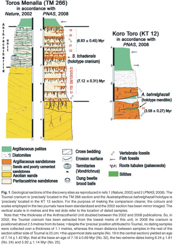
From January 1994 to July 2002, the author of the present note was in charge of every palaeontological field expedition that took place in the Chadian desert. In the interests of scientific accuracy, he is compelled to state formally that neither of these fossils was found in situ. The most appropriate word to employ for the two fossils would be that they were 'collected' from their respective localities, which are the sites TM 266 in Toros Menalla and KT 12 in Koro Toro for S. tchadensis and A. bahrelghazali, respectively. The published geological sections of the two discovery sites are reproduced in Fig. 1.
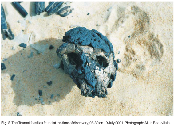
Toumaï was picked up from a land surface comprised of loose sand, which is constantly reworked by the wind. Day after day, the wind-driven sand abraded the right side of the skull, in particular its maxilla, and deeply eroded its mandible. The surface of the ground at the site is constituted of four to five centimetres of detrital deposits, from which the wind produces a deflation lag by removal of fine particles, a lag which protects the underlying deposits from further erosion until its surface is disturbed, as is frequently the case in desert terrain. If this lag surface is disturbed by sweeping or other activity, within a few hours the wind creates a rough surface, removing the underlying soft deposits and leaving the hard clasts, including fossils, in relief.
The photograph taken by the author at the moment of discovery has been widely published but never with a proper explanation. He thought that the image was sufficiently evocative to indicate the lack of stratigraphical context of the fossil (Fig. 2). It is time to correct this omission. In the image, the hollow in the sand to the right of the skull is the exact spot at which Toumaï was found. Almost all the fossils from TM 266 were in similar situations with respect to the substrate. By a curious choice, the photographs of Toumaï published by the MPFT as representing its field context are in reality those of a darkened resin cast, posed in the desert on a ridge of sand created by the northeast winds in February 2004.
As for Abel, the jaw fragment was found at the edge of a shallow gully exposing a mixture of coarse sand, gravel and small fragments of ironstone, as shown in the image taken at the time of the discovery (Fig. 3). The ground surface at the site is constituted of 5 cm of detrital deposits washed down slope by flowing water and then subjected to the action of wind. At KT 12, the slope of the land and the occurrence of violent rain storms at irregular intervals result in severe fluvial erosion (Fig. 4). Abel was not extracted from the argillaceous grit as was written in the PNAS.2 The white grit that underlies the unconsolidated detrital surface deposits is very hard when dry, but becomes soft when wet after the rain, as the author experienced in July 2000, a difference most likely due to the presence of salt in the deposits.
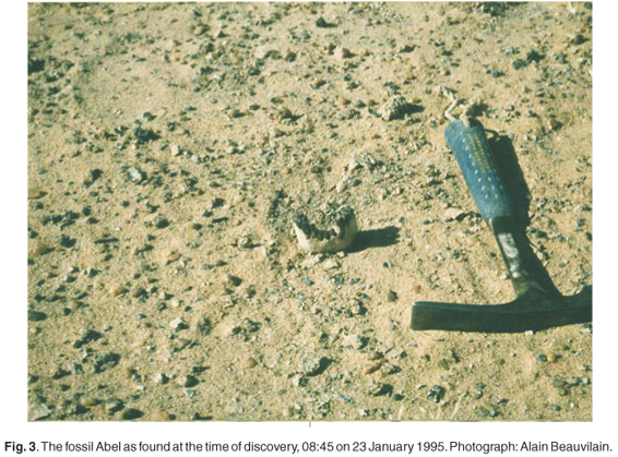

No other fossil was found in situ close to, or even at the same topographic level as, Abel. A few fossils were found with fragments of ferruginous crust adhering to them, indicating the former presence of such a crust somewhere in the sequence. Down slope and several dozen metres west of the precise spot where Abel was discovered, there are well-exposed outcrops of a similar ferruginous crust.
In the circumstances, determining the precise positions of Toumaï and Abel in the stratigraphic sections at TM 266 and KT 12 is impossible. At present, the slope of the ground at both of the sites favours erosion by rainwater, which in this part of the desert falls in rare but violent storms. Abel was collected at the foot of the shoreline of the last episode of Lake Megachad, which is only a few thousand years old. Prior to that it lay on the edge of the lake bed, perhaps even near an intermittent river mouth, as is suggested by a bend in the ancient shoreline deposits at this precise spot; prior to that, it lay on an eroded land surface which extends eastwards of the shoreline. The recent context of Toumaï is different. As is well known in desert areas, lateral movements of hard objects lying on loose sand can occur when wind removes the sand from one side of the object, creating a depression into which the hard object rolls. Repeated many times, such a process can move objects many metres in a few years. Soldiers know this phenomenon well as it can result in lateral and vertical shift of land mines. Considering the length of time that the fossils may have been exposed, it is considerably more likely that they have moved both laterally and vertically as a result of the combined action of oft-repeated aeolian undercutting and deflation and less common but more active displacement by flowing water, than that they did not suffer either vertical or lateral movement.
It should also be noted that most of the Djourab is affected by pastoral activity, as is attested by the presence of large herds of camels which can trample fossils into the soft substrate, and can scuff them over the surface, further complicating their contextual history (Fig. 5).

Toumaï was found loose on the land surface but almost entirely englobed in a ferruginous crust on which a well-developed desert varnish formed a patina that also occurs on the bone beneath the ferruginous crust. How many times was it exposed and reburied by shifting sands before being picked up by the expedition that the author organized and led in July 2001? As for Abel, the stratigraphic section of the site where it was found, published by the MPFT in the PNAS,2 shows two unconformable surfaces. What happened to the fossils during these two erosion cycles?
At a larger scale, vertical displacements of hard objects lying on ground comprised of loose soil occurs when aerodynamic conditions cause turbulence on the lee side of dunes, which exposes grits at the foot of the dunes. For this reason, the author systematically re-examined the foot of every dune during every new expedition in Djourab. This was how he found the first fragment of the hominid mandible TM 292, which led to his colleagues finding the other fossils. Furthermore, wind action in the vicinity of certain kinds of dunes can excavate veritable trenches at the foot of the dunes (Fig. 6). There are examples of this kind of landform more than 5 metres deep less than 20 kilometres from TM 266. From these depressions, aeolian erosion can proceed extremely rapidly, creating a new base level over a wide area. We observed just how fast such processes can occur in the Djourab, where a dune advanced rapidly on site TM 267, immediately east of TM 266. A little further away, an exposed block of sediment of more than 30 cubic metres was completely eroded away in a few weeks.

It should be noted that since the discovery of the two hominid fossils discussed in this article, the gritty lag surfaces of sites KT 12 and TM 266 have been swept and re-swept and even excavated in order to find microfossils, with success as it happens. In contrast, abundant fossils were brought to light in situ at TM 254 and in KB (Kossom Bougoudi) and KL (Kollé).
The article published in PNAS merits further observations. The first is that the famous sediment unit named the Anthracotheriid Unit (AU), which was about 2 metres thick in the 2002 Nature article, attains a thickness of 4.2 metres in the PNAS paper. In addition, the Toumaï cranium, said in 2002 to have been extracted from the lowest metre of this unit, appears in the 2008 paper to be positioned near the middle of this unit, 2.5 metres from its base. How is it possible to justify such a difference unless it is accepted that the skull was collected from an aeolian lag surface and that the base of the AU is not clearly discernible in the field, just as its top is non-existent due to its removal by erosion?
The second observation is related to the density of samples made for radioisotopic dating of site TM 266. The importance of this site resulted in 14 age determinations scattered through a thickness of 3.6 metres of section, corresponding to an age determination for every 25 cm on average. Curiously, the 'precise level' at which Toumaï was collected did not yield any results ('not applicable', it is explained in the paper). Even more surprising, no results are provided for a thickness of 1.1 metres either side of the 'precise location' of the hominid fossil. This remark is perhaps of little importance because the deposits at 5.4 metres yielded an age of 7.18 ± 0.69 Myr and those at 9 metres yielded an age of 7.14 ± 1.42 Myr, the two extreme dates being 8.24 ± 1.81 Myr (level 24 in Fig. 1) and 5.92 ± 1.14 Myr (level 25 in Fig. 1).
In addition, the caption for Table 2 in the PNAS paper indicates that the altitude of the base of the sections for TM 254, TM 266, KT 12, KL and KB 1 (the 0 base level), is that of the section at TM 266, whereas in Fig. 1 in the PNAS paper a thick horizontal line links the 5-metre level at TM 254 to the 5-metre level at TM 266, giving the impression that it is the same altitude. Therein lies an ambiguity, which needs attention because the altitude of site KT 12 (16°00'21"N; 18°52'34"E) is 322 m, that of KL (16°20'N; 18°58'E) is between 318 and 323 m, that of KB 1 (16°22'; 18°42'26"E) is 288 m and those of the two sites at TM 254 (16°17'18"N; 17°19'48"E) and TM 266 (16°15'12"N; 17°29'29"E) are 216 and 261 m, respectively (altitudes obtained from Google Earth, respectively given as 215 m and 257 m by NASA SRTM3 and SRTM30). Even though the difference in altitude is of the order of 40 m over a distance of 18 km, it is explained that the sediments were deposed synchronously and instantaneously on the basis of analyses 'well documented at 20 intervening sections'. The topography confirms the presence of small-scale tectonic movements in the area, which the author evoked in a previous article in this journal,4 activity that has since been accepted by the MPFT. All this renders the figure caption confusing at the very least.
Turning to the dating of the deposits, it is astonishing that for the sites KT 12, KB 1 and KL the samples were obtained from pelites, siltites and diatomites to the exclusion of the clayey grits, which are shown in Figs 1 and 2 in the PNAS paper to be the lithology from which all the terrestrial vertebrate fossils were collected. Finally, with the exception of the dating of KT 12 and the supposed 'precise position' of Abel in the section, the dated samples were collected only from the upper metre and a half of the sedimentary deposits. At KL, all the fossiliferous levels are topographically beneath the dated levels, and are thus older than them, as was already revealed by the biochronological analysis carried out as soon as the fossils were found in the field. At KB 1, the date samples were taken between an upper fossiliferous level and all the other topographically lower levels. The published section of this site, which is not extensive and forms a small basin, does not reveal whether it includes the top of the edge of the basin. Under the pelites and diatomites at KB 1, the fossiliferous layer is topographically lower than the dated samples, and thus older, which was also already evident from the biochronological analysis.
This is hardly surprising, because in the methodology section of the paper, it is explained that: 'Après avoir validé leur démarche et calibré leur nouvelle méthode en comparant les âges obtenus par cette dernière avec ceux estimés pour tous les niveaux fossilifères biochronologiquement contraints découverts dans l'erg du Djourab, les auteurs ont concentré leurs efforts sur la zone fossilifère dont a été extrait le crâne sub-complet de Toumaï.' (After having validated their approach and calibrated the new method by comparing the ages obtained with those estimated for all the fossiliferous levels in the Djourab Erg, the authors concentrated their efforts on the fossiliferous area where the incomplete skull of Toumaï was extracted.) One should perhaps be pleased that having calibrated their method on the basis of the biochronological aspect of the faunas from the same sites, these same ages appear as the results of the study.
Finally, it should be noted that site KB 1, which yielded only a handful of fossils, is located more than 4 km north of a fossiliferous area that yielded thousands of fossils, not counting the micromammals, from 25 contiguous sites located along the lower slopes of a long ridge. Topographically, KB 1 is also 7 metres lower. This important fossiliferous zone at KB merits its own dating programme, like that at KL, and not just on a peripheral site of little value—unless there was an error in the numbering of the KB localities.
As for the precise geographic positions of the localities, whereas the PNAS article pretends to indicate their precise locations within the sections, it does not provide the coordinates of sites KB, KL, nor of TM 254, and the authors provide only rounded-down coordinates for TM 266 and KT 12. For the latter two sites, the rounding down results in identifying a spot almost 1 km from the discovery site of Toumaï and more than 1 km for KT 12, thereby locating the site in the Holocene shoreline deposits of Lake Megachad. A glance at Google Earth will reveal how significant this difference in location is.
The answer to the question raised in the title of this article is that the hominid fossils from the Djourab in Chad were collected from surface lags, and were not as has often been written, found embedded in sediment with precise stratigraphic positions from which they were unearthed. As experienced palaeontologists well know, there can be a world of difference between the age of the substrate and that of a fossil found as lag on its surface.
In conclusion, there are two possibilities regarding the stratigraphic context of a fossil, in situ or not in situ. When found, neither Abel nor Toumaï was in situ.
1.Vignaud P. et al. (2002). Geology and palaeontology of the Upper Miocene Toros-Menalla hominid locality, Chad. Nature 418, 152–155. [ Links ]
2. Lebatard A.-E. et al. (2008). Cosmogenic nuclide dating of Sahelanthropus tchadensis and Australopithecus bahrelghazali: Mio-Pliocene hominids from Chad. Proc. Natl Acad. Sci. USA 105(9), 3226–3231. [ Links ]
3. Guy F. et al. (2008). Symphyseal shape variation in extant and fossil hominoids, and the symphysis of Australopithecus bahrelghazali. J. Hum. Evol. 55, 37–47. [ Links ]
4. Beauvilain A. and Leguellec Y. (2005). Further details concerning fossils attributed to Sahel- anthropus tchadensis. S. Afr. J. Sci. 100, 142–144. [ Links ]

