


Servicios Personalizados
Articulo
 Inglés (pdf)
 Articulo en XML
 Referencias del artículo
Indicadores

Links relacionados
-
 Citado por Google
 -
 Similares en Google
Compartir

 Permalink
South African Journal of Science
versión On-line ISSN 1996-7489
versión impresa ISSN 0038-2353
S. Afr. j. sci. vol.104 no.3-4 Pretoria mar./abr. 2008
RESEARCH LETTERS
Interaction of Agulhas filaments with mesoscale turbulence: a case study
C. WhittleI; J.R.E. LutjeharmsI, *; C.M. Duncombe RaeII; F.A. ShillingtonI
IDepartment of Oceanography, University of Cape Town, Private Bag, Rondebosch 7701, South Africa
IIMarine & Coastal Management, Department of Environmental Affairs and Tourism, Private Bag X2, Roggebaai 8012, South Africa
ABSTRACT
The inter-ocean leakage of heat and salt from the South Indian Ocean to the South Atlantic has important consequences for the global thermohaline circulation and in particular for the strength of overturning of the Atlantic Ocean as a whole. This leakage between these two subtropical gyres takes place south of Africa. The main mechanisms are the intermittent shedding of Agulhas rings from the retroflection of the Agulhas Current and the advection of Agulhas filaments from the border of the Agulhas Current, both of which move northwestward into the South Atlantic. The subsequent behaviour and mixing of Agulhas rings has been much studied over the past years, that of Agulhas filaments not at all. We report here on fortuitous hydrographic observations of the behaviour of an Agulhas filament that interacted with a number of mesoscale features shortly after formation. This suggests that Agulhas filaments may be involved in many other circulation elements and not only the Benguela upwelling front, as was surmised previously, and may mix out in a very site-specific region.
Introduction
Heat and salt are distributed and circulated throughout the world's oceans via the global thermohaline circulation. The oceans adjacent to southern Africa form an important component of this circulation.
The Agulhas Current is the western boundary current of the South Indian Ocean and acts as a link between the Indian and Atlantic oceans1 in the following way. South of Africa the current retroflects abruptly and about 90% of its water mass transport is returned to the South Indian Ocean.2 Shedding of huge Agulhas rings at the retroflection and the advection of filaments—from the upper layers of the landward border of the current—account for the remaining 10% of Agulhas Current water mass transport. These Agulhas Current products leak into the South Atlantic Ocean; the annual contribution to inter-basin salt exchange of filaments being about 15% of that of Agulhas rings.3 The South Atlantic is unique as an ocean basin since it is the only one in which there is a net equatorward heat transport.4 This may be largely controlled by the process of inter-ocean exchange south of Africa. In fact, modelling studies indicate that the transfer of water between the Atlantic and Indian oceans controls the rate of thermohaline overturning of the whole Atlantic Ocean.5
The fate of Agulhas rings, as well as the mechanisms by which they distribute their heat and salt content into the Atlantic Ocean, have been subjected to intense scientific scrutiny, e.g. in the Mixing of Agulhas Rings Experiment (MARE)6 and in the Cape of Good Hope Experiments (KAPEX).7 Investigations by Schouten et al.8 have demonstrated, for instance, that rings may dissipate very rapidly in the Cape Basin, west of Cape Town. Persistent ring–eddy interactions between Agulhas rings and smaller cyclonic eddies9 suggest one possible mechanism by which the physical properties of an Agulhas ring may rapidly be eroded. The Cape Basin therefore plays an integral role as a region of mixing and stirring in the Indian–Atlantic inter-ocean exchange.
The flux of salt by the other leakage component, Agulhas filaments, has been estimated as making a much smaller contribution to inter-ocean leakage than that of Agulhas rings.3 The mixing processes undergone by these features have therefore been considered of lesser importance and have not been studied as yet. Early work10 has suggested that they follow the coastal upwelling front along the southwestern coast of South Africa, thereby intensifying this front. Fortuitous observations at sea have now made it possible to make a first contribution to an understanding of the mixing processes of Agulhas filaments.
Data and processing
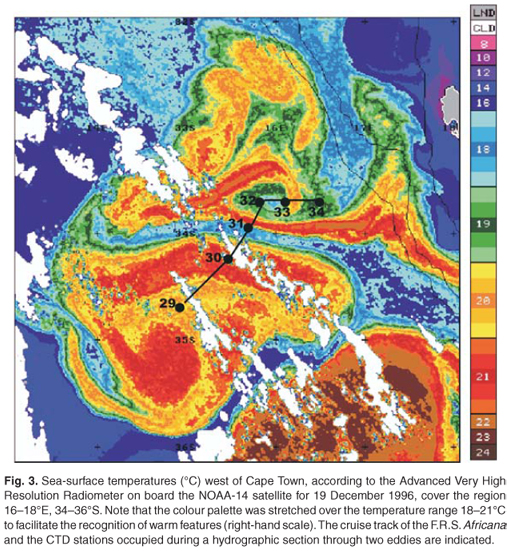
In late December 1996, the F.R.S. Africana successfully surveyed an apparent dipole vortex in the southeastern Atlantic Ocean (Fig. 3). Hydrographic data were sampled with a Neil Brown Instrument Systems Mark III CTD (conductivity–temperature–depth) unit and Sippican T7 XBTs (expendable bathythermographs) were launched between CTD stations. All calibration and validation of the hydrographic data set were completed at the Marine and Coastal Management (MCM) division of the Department of Environmental Affairs and Tourism. Prior to deployment, XBTs were calibrated against sea-surface temperature with a Crawford Bucket.11 The CTD probe was calibrated at MCM before and after the cruise. Pressure was calibrated against a Budenberg Dead Weight Tester, and temperature was calibrated against a Hewlett Packard 1804A quartz thermometer. Salinity samples were obtained at selected stations for calibration purposes and MATLAB conversion software was used to apply the salinity corrections and a median filter to the CTD data. Outliers were removed.
Two sources of sea-surface temperature data, obtained from the Advanced Very High Resolution Radiometer (AVHRR) on board polar-orbiting satellites of the NOAA series, were used to monitor the circulation after the cruise. In the three weeks leading up to the cruise, circulation features were followed on Global Area Coverage Pathfinder AVHRR data obtained from the University of Miami's Rosenstiel School of Marine and Atmospheric Science. At the University of Cape Town, local area coverage AVHRR data, obtained from the Satellite Applications Centre at Hartebeesthoek, acquired by the NOAA-14 satellite, was processed using the PC-SEAPAK image processing software. This AVHRR instrument has a spatial resolution of approximately 1.1 km2 at nadir and provides sea-surface temperature estimates with an accuracy <0.5°C.12
Sea-surface temperatures
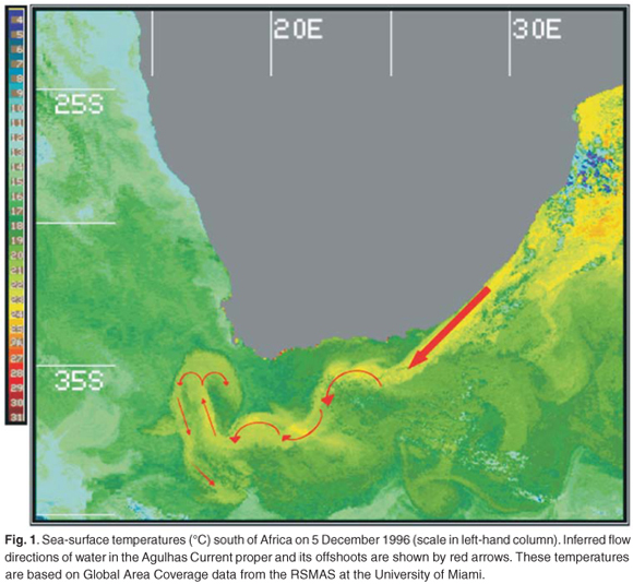
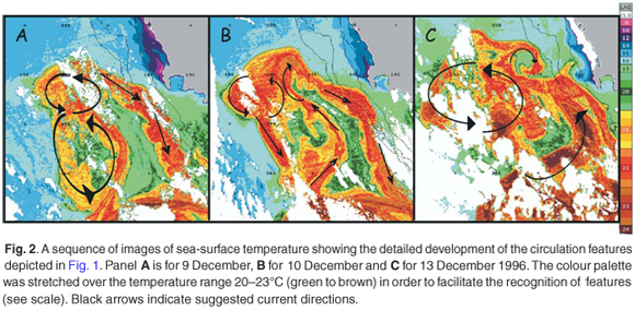
The oceanic environment prior to the cruise, on 5 December 1996, is shown in Fig. 1. The Agulhas Current can be identified very close to the east coast of South Africa (thick red arrow) by 23–24°C surface temperatures. The current then followed the eastern side of the Agulhas Bank away from the coast and meandered, with shear edge features being formed on its shoreward edge before it retroflected at about 16ºE. Here the circulation indicates that a retroflection loop may have extended substantially northward while there was a cyclonic movement on the shelf side of the equatorward intrusion. The latter agrees with the formation of a lee eddy frequently observed here.13 Such mushroom-shaped intrusions of warm Agulhas water into the South Atlantic, evident here, have been observed before.14 According to Mied et al.,15 mushroom-like patterns of this kind are likely to result from the immature, or generational, stages of a vortex dipole. Could the subsequent development of these features give one an indication about the mixing processes prevalent here at the time? The series of images given in Fig. 2 shows this subsequent behaviour.
By 9 December (panel A, Fig. 2), the mushroom-shaped feature evident in Fig. 1 had become distorted. A filament of warm water was still moving southward along the western edge of the Agulhas Bank. On the western side of the main intrusion of warm water the circulation consisted of two cyclonic eddies. The next day, 10 December (panel B, Fig. 2), the warm water had protruded about 70 km farther equatorward. By 13 December the northward flow of warm water in what may be considered an Agulhas filament had strengthened, judging by the higher temperatures, the water now coming directly from the Agulhas Current. The southward flow on the eastern boundary of the Agulhas Bank had weakened and the most northern part of the protrusion has broken up into a largish anti-cyclone to the west and a small cyclone to the east. Wind-driven upwelling along the coast had weakened, but along its western side a filament of warm Agulhas water was being drawn into a cold upwelling eddy west of Cape Town that is a recurrent feature of the upwelling front here.17 This complex and rapidly changing scenario raises an important question. Was one dealing here with an Agulhas ring, or was this only an Agulhas filament interacting with a host of mesoscale features? Observations made during a research cruise to the region at the time may give the answer.
By 19 December 1996 (Fig. 3), the features were well-resolved, the warm water (>20°C) embedded in a cooler background (<18°C). Some of the individual features evident in Fig. 2 had been separated by intrusions of colder water. The dominant feature was a pool of warm water centred on 35°S, previously identified as an anti-cyclonic eddy, possibly an Agulhas ring. A shear edge filament on its south-western side suggests that this interpretation of its circulation direction is correct. Surface temperatures varied from 19°C at the outer edges to 21°C inside this warm eddy. The warm filament (Fig. 2) on the eastern side of the whole protrusion and the small cyclonic eddy it had surrounded had moved westward whereas another part of the filament was moving along the coastal upwelling front. Hydrographic stations intersected part of the anti-cyclonic eddy, the intact cold filament to the north and the small cyclone at about 16°E (Fig. 3). This cyclone had surface temperatures of 17°C in its centre and 22°C in the encircling filament. The structures to a depth of 1200 m of all these features are shown in Fig. 4.
Hydrographic section
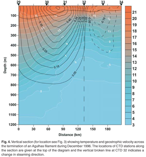
Six CTD stations (numbers 29–34) were occupied from 22–23 December 1996. As mentioned above, XBTs were deployed between CTD stations to increase the spatial temperature coverage. An upper mixed layer of >20°C is evident down to 100 m on the temperature profile between CTD 29 and CTD 31 (Fig. 4). The expected vertical temperature characteristics of the eastern side of an anti-cyclonic eddy are shown by the downward slope of isotherms. The isotherms deepened towards CTD 29, with the 10°C isotherm indicating an overall depression of approximately 315 m with respect to the estimated edge of the ring (CTD 31). This is comparable to Agulhas rings observed here before.18,19 Assuming that CTD 29 represents the approximate centre of the ring, a radius of at least 110 km can be estimated from combined satellite and hydrographic information. These observations agree with that of other Agulhas rings6,20 surveyed near the retroflection region. The distinctive upward doming of isotherms at CTD 32 is in turn indicative of the cyclonic eddy identified in Fig. 3. A 100-m rise in the 10°C isotherm is noted at this position and the radius for this feature is estimated at approximately 38 km.
Geostrophic velocities between stations were calculated relative to the 900 db position because most CTD casts were to this depth or more. Between CTD 30 and CTD 31, a peak westerly flow of at least 0.65 m/s was calculated for the upper 50 m of the water column, marking the edge of the anti-cyclonic eddy (Fig. 4). It is interesting to note that the cold water filament at CTD 31 (Fig. 3) overlay the edge of the anti-cyclonic eddy (Fig. 4). This speed is fairly representative of Agulhas rings relative to 900 db. The core of the small cyclonic eddy lay at CTD 32 (Fig. 3), which is evident also from the current speeds (Fig. 4), which shows a change of direction at this point. The maximum speed at the edge of this cyclone, between CTD 32 and CTD 33 (Fig. 3), was 0.15 m/s southward (Fig. 3). More about the possible origin of the water masses in each of these mesoscale features may be learnt from their individual temperature–salinity (T–S) characteristics (Fig. 5).
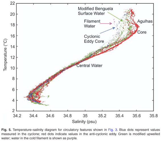
There are a number of distinct water masses present south-west of southern Africa, including tropical and subtropical surface waters, thermocline waters (comprising South Atlantic Central Water, South Indian Central Water and tropical Atlantic Central Water), Antarctic Intermediate Water, North Atlantic Deep Water and Antarctic Bottom Water.21 A number of water masses can be identified in Fig. 5: Antarctic Intermediate Water (AAIW) with a temperature range of 4–5°C and a salinity range of 34.32–34.45; Red Sea Intermediate Water (RSIW) with a temperature range of 4–5°C and salinity >34.5; Central Water (CW) with a temperature range of 6–16°C and salinity range of 34.44–35.39, although at a temperature >12°C two discrete T–S curves are evident with salinity values ranging from 35.04–35.39 and 35.04–35.53, respectively; surface waters which have temperature values >16°C and salinity values ranging from 35.37–35.60.
In the core of the anti-cyclone, AAIW was found at a depth of approximately 1025 m, which is close to the depth of 1100 m at which AAIW is found in the Agulhas retroflection region.21 The AAIW identified in the cyclone and other water, sampled in close proximity to the two eddies, was found at a depth of only 800 m. AAIW is usually present at this depth in the South-East Atlantic Ocean.21 Indian Ocean AAIW (Agulhas Current origin) has a salinity value >34.45 and South-East Atlantic Ocean AAIW (Benguela Current) has salinity values ranging from 34.2–34.5.22 At CTD 14, located on the edge of the anti-cyclone, a salinity maximum >34.5 was observed in the intermediate water layer with a potential density in excess of 27.2, indicating the influence of RSIW.23 Such filaments of RSIW at the edge of Agulhas rings have been observed on a number of occasions.
It is difficult to distinguish between central waters of the South-East Atlantic Ocean itself and those advected here by Agulhas rings and filaments from the Indian Ocean.24 The more saline CW (>12°, Fig. 5) was observed in the anti-cyclone; fresher CW represents largely the cold filament, the cyclone and water outside the warm features. Warmer CW identified in the anti-cyclone has the characteristics of South Indian Central Water that has a temperature range of 8–15°C and salinity values ranging from 34.5–35.5.24 South Atlantic CW has a temperature range of 6–16°C and salinity values ranging from 34.5–35.5.22 These values agree well with the CW (>12°C) sampled outside the anticyclone core. This shows that the anti-cyclone was indeed of Indian Ocean origin and thus without much doubt an Agulhas ring.
The surface waters also illustrate the different characteristics of the anti-cyclone, the cyclone and the cold filament. Warmer and more saline waters are found in the anti-cyclonic eddy. By contrast, surface waters of the cyclonic eddy (>17°C, >35.4) suggest water of Benguela upwelling water origin.24 The coldest surface water was found in the cold filament. It suggests that this water may even have come from the Subtropical Convergence, a not unlikely occurrence in this region.25
Discussion
Various factors conspired to create the ensemble of mesoscale circulation elements surveyed by the F.R.S. Africana in December 1996. First, a strong Agulhas filament was observed west of the Agulhas Bank. The combination of an anti-cyclonic off-shore Agulhas ring and a cyclonic eddy in the lee of the Agulhas Bank —both circumscribed by the filament of warm water originating in the current—resulted in a mushroom-shaped circulation configuration.
All features were subsequently advected in a northward direction, but rapidly changed their shapes, dispositions and complexity. On reaching the latitude of Cape Town, a small cyclone on the landward side of the Agulhas ring was formed. The water that had flowed southward along the western edge of the Agulhas Bank became less prominent and a strong new inflow of warm surface water from the Agulhas Current occurred. By the time of the cruise (Fig. 3), the different elements of this circulation had become separated by distinct filaments of cold water.
In previous investigations3,10 on the eventual fate of Agulhas filaments it was concluded that they move equatorward along the shelf edge in a relatively undisturbed way, eventually joining the coastal upwelling front to the north. This case study now demonstrates that this is not always the case.
The satellite time series (Figs 1 and 2) shows that warm surface water from the Agulhas Current, on being advected poleward, was drawn around a large anti-cyclone. The hydrographic and current speed observations demonstrate unequivocally that this anti-cyclone was an Agulhas ring. It is clear that the Agulhas filament refurbished the surface layers of the ring with a fresh insertion of warm surface water from the Agulhas Current. Second, part of the Agulhas filament was subsequently advected southward by an eddy in the lee of the Agulhas Bank. Third, the formation of cyclonic shear edge eddies on the border of the Agulhas ring and the drawing in of cold shelf waters into such a feature presents another mechanism for enhanced mixing of water of an Agulhas filament. Fourth, it is clear that the whole collection of different eddies became intermingled with filaments of cold water that may, based on the T–S characteristics of their waters, have come from the Subtropical Convergence. Last, but not least, a small part of the warm water of the Agulhas filament did eventually get absorbed into the frontal region of the coastal upwelling regime.
Conclusion
All the circulation features observed on this occasion—Agulhas rings, lee eddies and upwelling front eddies—have been seen before and are known to a greater or lesser extent. What is decidedly novel, however, is the movement and behaviour of the warm water in an Agulhas filament.
It is clear that the amount of interaction, shearing and deformation observed in this collection of circulation features rapidly mixed the warm water contribution in the original filament from the Agulhas Current. If this case study represents the characteristic mixing processes of this region, it implies that the anomalous heat and salt contribution to inter-ocean exchange by Agulhas filaments will be rapidly dissipated in the southeastern corner of the Cape Basin, near Cape Town, and not along the coastal upwelling front only. In a certain sense this parallels the dissipation of Agulhas rings that lose most of their energy and consistency in the Cape Basin.8 In future investigations it will be important to establish how representative the mixing processes shown in this case study are.
We are grateful to the officers and crew of the F.R.S. Africana, and to all others who assisted in the collection and processing of the hydrographic data. We thank the Satellite Applications Centre of the CSIR for the NOAA satellite data and Scarla Weeks for assistance in processing AVHRR data. The study was partially funded by the National Research Foundation.
1. Gordon A.L., Weiss R.F., Smethie W.M. and Warner M.J. (1992). Thermocline and intermediate communication between the South Atlantic and Indian Oceans. J. Geophys. Res. 97, 7223–7240. [ Links ]
2. Stramma L. and Lutjeharms J.R.E. (1997). The flow field of the subtropical gyre in the South Indian Ocean. J. Geophys. Res. 102, 5513–5530. [ Links ]
3. Lutjeharms J.R.E. and Cooper J. (1996). Inter-basin leakage through Agulhas Current filaments. Deep-Sea Res. 43, 213–238. [ Links ]
4. De Ruijter W.P.M., Biastoch A., Drijfhout S.S., Lutjeharms J.R.E., Matano R.P., Pichevin T., van Leeuwen P.J. and Weijer W. (1999). Indian–Atlantic inter-ocean exchange: dynamics, estimation and impact. J. Geophys. Res. 104, 20,885–20,911. [ Links ]
5. Weijer W., de Ruijter W.P.M., Dijkstra H.A. and van Leeuwen P.J. (1999). Impact of interbasin exchange on the Atlantic overturning circulation. J. Phys. Oceanogr. 29, 2266–2284. [ Links ]
6. Van Aken H.M., van Veldhoven A.K., Veth C., de Ruijter W.P.M., van Leeuwen P.J., Drijfhout S.S., Whittle C.P. and Rouault M. (2003). Observations of a young Agulhas, Astrid, du MARE in March 2000. Deep-Sea Res. II 50, 167–195. [ Links ]
7. Lutjeharms J.R.E., Boebel O. and Rossby T. (1997). KAPEX: an international experiment to study deep water movement around southern Africa. S. Afr. J. Sci. 93, 377–381. [ Links ]
8. Schouten M.W., de Ruijter W.P.M., van Leeuwen P.J. and Lutjeharms J.R.E. (2000). Translation, decay and splitting of Agulhas rings in the south-eastern Atlantic Ocean. J. Geophys. Res. 105, 21,913–21,925. [ Links ]
9. Boebel O., Lutjeharms J.R.E., Schmid C., Zenk W., Rossby H.T. and Barron C. (2003). The Cape Cauldron: a regime of turbulent inter-ocean exchange. Deep-Sea Res. II 50, 57–86. [ Links ]
10. Lutjeharms J.R.E. (1981). Satellite studies of the South Atlantic upwelling system. In Oceanography from Space, ed. J.F.R. Gower, pp. 195–199. Marine Science Vol. 13, Plenum Press, New York. [ Links ]
11. Crawford A.B. (1972). Sea surface temperature measurements by direct sampling. Maritime Weather Office, Youngsfield, Cape Town, South Africa. [ Links ]
12. McClain E.P., Pichel W.G. and Walton C.C. (1985). Comparative performance of AVHRR-based multichannel sea surface temperatures. J. Geophys. Res. 90, 11,587–11,601. [ Links ]
13. Penven P., Lutjeharms J.R.E., Marchesiello P., Weeks S.J. and Roy C. (2001). Generation of cyclonic eddies by the Agulhas Current in the lee of the Agulhas Bank. Geophys. Res. Lett. 28, 1055–1058. [ Links ]
14. Lutjeharms J.R.E. and Walters N.M. (1985). Ocean colour and thermal fronts south of Africa. In South African Ocean Colour and Upwelling Experiment, ed. L.V. Shannon, pp. 227–237. Sea Fisheries Research Institute, Cape Town. [ Links ]
15. Mied R.P., McWilliams J.C. and Lindemann G.J. (1991). The generation and evolution of mushroom-like vortices. J. Phys. Oceanogr. 21, 1569–1582. [ Links ]
16. Lutjeharms J.R.E., Durgadoo J.V. and Ansorge I.J. (2007). Surface drift at the western edge of the Agulhas Bank. S. Afr. J. Sci. 103, 63–67. [ Links ]
17. Lutjeharms J.R.E. and Matthysen C.P. (1995). A recurrent eddy in the upwelling front off Cape Town. S. Afr. J. Sci. 91, 355–357. [ Links ]
18. Gordon A.L., Lutjeharms J.R.E. and M.L. Gründlingh (1987). Stratification and circulation at the Agulhas Retroflection. Deep-Sea Res. 34, 565–599. [ Links ]
19. Duncombe Rae C.M., S.L. Garzoli and Gordon A.L. (1996). The eddy field of the southeast Atlantic Ocean: a statistical census from the Benguela Sources and Transports Project. J. Geophys. Res. 101, 11,949–11,964. [ Links ]
20. Duncombe Rae C.M. (1991). Agulhas retroflection rings in the South Atlantic Ocean; an overview. S. Afr. J. Mar. Sci. 11, 327–344. [ Links ]
21. Valentine H.R., Lutjeharms J.R.E. and Brundrit G.B. (1993). The water masses and volumetry of the southern Agulhas Current region. Deep-Sea Res. 40, 1285–1305. [ Links ]
22. Shannon L.V. and Hunter D. (1988). Notes on Antarctic Intermediate Water around Southern Africa. S. Afr. J. Mar. Sci. 6, 107–117. [ Links ]
23. Roman R. and Lutjeharms J.R.E. (2007). Red Sea Intermediate Water at the Agulhas Current termination. Deep-Sea Res. I 54, 1329–1340. [ Links ]
24. Shannon L.V. and Nelson G. (1996). The Benguela: Large scale features and processes and system variability. In The South Atlantic: Present and Past Circulation, eds G. Wefer, W.H. Berger, G. Siedler and D.J. Webb, pp. 163–210. Springer-Verlag, Berlin. [ Links ]
25. Lutjeharms J.R.E. and Fillis C.S. (2003). Intrusion of sub-Antarctic water across the Subtropical Convergence south of Africa. S. Afr. J. Sci. 99, 173–176. [ Links ]
Received 21 August 2007. Accepted 18 April 2008.
* Author for correspondence. E-mail: johann.lutjeharms@uct.ac.za

