


Services on Demand
Article
 English (pdf)
 Article in xml format
 Article references
Indicators

Related links
-
 Cited by Google
 -
 Similars in Google
Share

 Permalink
South African Journal of Science
On-line version ISSN 1996-7489
Print version ISSN 0038-2353
S. Afr. j. sci. vol.103 n.11-12 Pretoria Nov./Dec. 2007
RESEARCH LETTERS
Linear and nonlinear sea-level changes at Durban, South Africa
A.A. Mather
Coastal and Catchment Policy, Co-ordination and Management, eThekwini Municipality, P.O. Box 680, Durban 4000, South Africa. E-mail: mathera@durban.gov.za
ABSTRACT
The tide record between 1970 and 2003 for Durban, South Africa, is analysed to determine the extent of recent linear and nonlinear sea-level trends in the light of predicted global sea-level rise. Given the stability of the adjacent land mass, Durban is ideally suited to test global sea-level change. The linear trends of monthly mean sea level revealed a sea-level rise of 2.7 ± 0.05 mm/yr and the yearly mean sea-level trend revealed a rise of 2.4 ± 0.29 mm/yr. Nonlinear trends varied between –1 mm and +8 mm/yr. These findings are similar to recently published results of global sea-level rise calculations over the last ten years derived from worldwide tide gauge and TOPEX/Poseidon altimeter measurements, which range between 2.4 and 3.2 mm/yr.
The need to determine trends in sea-level change
There is growing worldwide awareness of the effects of climate change induced by human actions on our planet and, particularly, of the global effect of sea-level rise on coastal cities, towns and subsistence communities that rely on the sea for income and food. Urban settlements have expanded rapidly over the last thirty years, especially in developing countries, making more people vulnerable to this risk.1
Sandy beaches, which make up 34% of the world's coastline,2 form an integral part of most coastal cities' tourism potential. Tourism is an important economic activity in KwaZulu-Natal, and Durban's beaches constitute the province's most important tourist attraction, with 73% of domestic tourists visiting them.3 Rising sea levels will reduce the surface area of beaches, and the consequent damage to tourism infrastructure will impact adversely on the local tourism industry.
Coastal harbours are similarly vulnerable. Durban plans to double its container port capacity over the next few years.4 Port and harbour development is costly and developers plan for use of this infrastructure for up to a century or more.
Measurement of sea-level change has been in progress for decades, with the main focus on the northern hemisphere. Data from tide gauges have traditionally been used for this purpose. In the late 1990s, however, the use of satellite data became more prominent, chiefly because of poor geographical coverage by tide gauges, the influence of tide gauge records by land movement and the superior accuracy provided by satellite data. Historically, the analysis of sea-level trends has been undertaken using linear regression techniques, but more recently nonlinear analysis has been introduced.5
This paper examines current rates of sea-level rise for Durban and surrounding coastal areas based on the tidal records of the South African Navy's tide gauge located near the harbour entrance (31°00'E, 29°49'S) (Fig. A in supplementary material online). No such analysis has been done to date for Durban nor for any major coastal city on the east coast of Africa. The results are compared with published global sea-level changes.
Methods and results
The tide data used for this analysis were sourced from the South African Navy's Hydrographic Office. The most reliable records between 1970 and 2003 were selected and were received as hourly observed tide levels in Chart Datum (CD). The navy data were found to be unusable in their existing form. There are two other data records for Durban, one held by the British Oceanographic Data Centre (BODC) and the other by the Permanent Service for Mean Sea-level. These were evaluated and found also to contain several anomalies despite originating from a single tide recorder. This required a re-analysis of these data, to rectify and remove dubious records.6
The barometric data used in this study were obtained from the South African Weather Service, received as hourly recordings from the Durban International Airport weather station. Recorded tide data are influenced by meteorological effects. Compensation requires the extraction of the influence of barometric pressure, commonly referred to as 'inverted barometer' effects,7 as these can mask the true sea-level change. Correlation coefficients were established between changes in apparent sea levels, using the Durban tide gauge and changes in barometric pressure. These were –8.7 mm per hPa for annual readings and –5.9 mm per hPa for monthly readings (Mather, manuscript in preparation) and were applied to the data. The longer the period of analysis, the closer the correlation tended to the theoretical relationship of –9.9 mm per hPa.
Two different levels of analysis were undertaken. In the first method, using annual records, the data were analysed according to Pugh.8 This entailed refining the data, applying a weighting factor to account for discarded data, introducing a barometric correction and, finally, applying linear regression to the refined, weighted annual change. The second method used was similar to the first except for the omission of weighting factors, using monthly rather than annual change and the application of a barometric compensation of –5.7 mm per hPa, rather than the –8.7 mm per hPa used in the first method. Nonlinear trends for monthly mean sea levels were calculated using CATMV, a computer program developed by the Gistat group (www.gistatgroup.com ), based on the singular spectrum analysis (SSA) method.9,10
Results
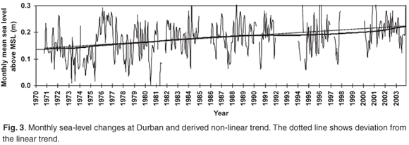
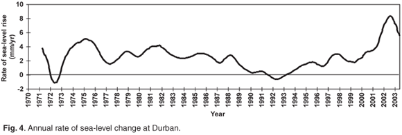
The linear analysis of monthly mean sea levels (MMSL) yielded a rate of sea-level rise of 2.7 ± 0.05 mm/yr at the 95% confidence level (Fig. 1). The linear analysis of yearly mean sea level (YMSL) yielded a sea-level rise of 2.4 ± 0.29 mm/yr (Fig. 2). Nonlinear trends (Fig. 3) show changes similar to the linear trends. On examination of the moving annual average trends (Fig. 4), however, it is possible to distinguish different phases. These range from approximately –1 mm/yr to +8 mm/yr. Only two periods show a negative trend, these being in 1972 and 1992. The two negative trends are of small magnitude, –1.1 mm/yr and –0.6 mm/yr, respectively. A positive trend is evident in the rest of the series, with the highest value of +8.4 mm/yr recorded in 2002.


Discussion
Sea-level trends around the world have shown varying amounts of sea-level variation, depending on the location and geological history of the site. Emery and Aubrey11 evaluated 587 gauges with records longer than ten years and identified only 36 that originate from stable coastlines. Only three of these sites were from southern Africa and all were situated on the west coast. As the southern part of the African continent is founded on a stable cratonic base, this makes the land mass around Durban tectonically stable.12 This obviates the need to correct for many of the other influences that pervade the tidal records, notably subsidence and post-glacial rebound. Durban is, therefore, one of relatively few sites in the world that can be used directly to assess global sea-level change.
Little recent research has been conducted in South Africa on rates of sea-level change calculated from tide gauge data. In 1984, Brundrit13 focused on sea-level changes only on the west coast of South Africa, and Hughes et al.14 examined changes on the west and Cape coasts with respect to sea-level measurements in the global context of sea level. Brundrit15 examined the tide gauge data at Lüderitz, Port Nolloth, Simon's Town and Mossel Bay, deriving trends from these sites. He omitted the east coast entirely, however. Except for the work of Cooper12,16,17 and Hughes,18 who used estimates of sea-level change to model coastal impacts, even fewer sea-level studies have been undertaken specifically for Durban.
A comparison of our results with this previous work was made. Cooper,16 quoting Hughes (pers. comm.), refers to Durban's tide record as showing 'little upward trend' and ascribes this to possible instrument error, land movement and/or other factors. This paper examines this particular period of the Durban record, and analysis clearly shows an upward trend. This anomaly may be attributable to previous workers' use of the British Oceanographic Data Centre record for Durban, which shows a downward trend, and not the official tide record from the South African Navy. The BODC record originates from the University of Cape Town via the University of Hawaii. The work of Cooper12,16 included a regional estimation of the effects that a 1-m sea-level rise could have on the KwaZulu-Natal coastline. This figure was chosen presumably as it reflected the upper limit of sea-level rise predictions at that time. All other previous work has been based on scenarios and none of the authors derived the actual sea-level rise for the east coast from tide data. Thus the data from this study are vital for future work.
The approach adopted in this study, based on MMSL and YMSL data from the available records, provides good correlation with more sophisticated analyses. Pugh8 points out that: 'This method is used by many authorities because it requires little mathematical insight, yet produces values close to that obtained by more elaborate tide-elimination techniques (Rossiter, 1958).'
It is important to note that calculations based on mean monthly sea level almost always yield different answers to those based on yearly mean sea-level calculations. Time series plots of YMSL values appear to be smoother than those of MMSL values. As there are 12 times more data points in the mmSL record, however, this effectively increases the sample size of MMSL plots, leading to a smaller standard error of the regression coefficient.
Linear regression analysis is a relatively easy and popular tool whereby sea-level trends can be obtained. This method has its defects, however. Regressional analysis is sensitive to the starting position of the analysis and, therefore, is inappropriate for periods of a decade or less, because of the multi-year cycles present in the tide record.5,19 These cycles, if not properly accounted for in the analysis, mask longer-term trends in the data.
Nonlinear techniques, on the other hand, are more robust and not as sensitive to the start position. Two approaches considered for this analysis were the empirical mode distribution (EMD) 20,21 and singular spectral analysis (SSA).9 Both are effective in decomposing time series into trends and residual frequencies, allowing better understanding of the latent trends in the data. As with most data series, however, gaps are common and are difficult to deal with. CATMV, which uses SSA, was chosen here, as this software has a superior method of filling in data gaps.10
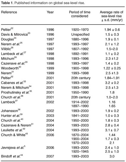
The comparison of these results with worldwide figures is shown in Table 1. Over the last century, the trend is towards an ever increasing rise-rate, which has led to speculation about future acceleration in rising sea levels. Church and White43 have subsequently established evidence of an acceleration in the rate of sea-level rise from extended (1870–2004) tide gauge records. For this reason comparisons with other sea-level changes are confined to time periods relevant to this study. Church and White43 examined the 1970–2003 period and obtained a global sea-level rise of 2.1 mm/yr. Many new analyses have been undertaken as a result of satellite altimeter data becoming available, Cabanes et al. 33 and Nerem and Mitchum 34 examined global sea-level rise for the period 1993–1998 and arrived at a figure of 3.2 ± 0.2 mm and 2.5 ± 1.3 mm/yr, respectively. Jevrejeva et al.5 derived a figure of 2.4 ± 1.0 mm/yr for the period 1993–2000. More studies were undertaken as the satellite data extended over longer time periods. Cazenave and Nerem41 and Leuliette et al.42 examined sea-level change over the period 1993 to 2003 and published results of approximately 2.8 ± 0.4 and 3.1 ± 0.7 mm/yr. Bindoff et al.44 updated the work of Cazenave and Nerem 41 and obtained a linear rate of sea-level rise of 3.0 mm/yr. All of these results are comparable and correlate well with the linear results of 2.7 ± 0.05 mm/yr obtained for Durban.
Nonlinear results show a constantly changing trend influenced by the multitude of different global changes at play. Analysis shows that, apart from one short period between 1972 and 1973, the major part of the record revealed an upward trend of varying degree. The period between 1972 and 1973 shows a downward trend of –2 mm/yr. The next period, which accounts for most of the time series, yields an almost uniform trend of +2.6 mm/yr.
A distinct advantage of nonlinear trends over linear trends is that discrete periods can be analysed against results obtained for comparable periods. A comparison for the period 1993–98 with the results obtained by Nerem and Michum34 from satellite data of 2.5 ± 1.3 mm/yr indicates trends from this study of 1.9 mm/yr, which falls into the range provided by Nerem and Michum. Cazenave and Nerem41 and Leuliette et al.42 undertook a further study for the period 1993–2003, which yielded 2.8 ± 0.4 mm and 3.1 ± 0.7 mm/yr and, compared to the result of 3.0 mm/yr obtained in this study, showed excellent agreement with global nonlinear variations of sea levels.
Based on the comparisons above, the linear rate of sea-level rise derived for Durban of 2.7 ± 0.05 mm/yr would appear to be valid for use at Durban and the surrounding areas.
Conclusion
The rate of sea-level rise of 2.7 ± 0.05 mm/yr for Durban and its adjacent coastline is consistent with previous worldwide research, clustering in a band between 2.4–3.2 mm/yr. These results are important in that they provide for the first time a locally measured rate of sea-level rise that can be used for strategic coastal planning, coastal management, and in the design of future port infrastructure and marine structures in the region.
I thank the South African Navy for the use of the tidal data and the South African Weather Service for the use of barometric data.
1. Rakodi C. and Treloar D. (1997). Urban development and coastal zone management. An international review. Third World Planning Review 19(4), 401–424. [ Links ]
2. Hardisty J. (1990). Beaches Form and Process. Unwin Hyman, London. [ Links ]
3. Anon. (2007). Statistics of our Tourism Industry. Tourism KZN, Durban. [ Links ]
4. Mather A.A., Redman T. and Akkiah P. (2006). Joint planning for the Port and City of Durban. In Proc. 10th International Conference Cities and Ports, Sydney, pp. 1–19. [ Links ]
5. Jevrejeva S., Grinsted A., Moore J.C. and Holgate S. (2006). Nonlinear trends and multiyear cycles in sea-level records. J. Geophys. Res. 111, C9, C09012. [ Links ]
6. Mather A.A. and Garland G.G. (2006). An analysis of Durban's tidal record from 1970 to 2003. South African Association of Geomorphologists conference on geomorphology and the environment. [ Links ]
7. Doodson A.T. (1924). Meteorological perturbations of sea-level and tides. Mon. Not. R. Astr. Soc. Geophys. Suppl. 1, 124–147. [ Links ]
8. Pugh D. (1987). In Tides, Surges and Mean Sea-Level, pp. 302–303. John Wiley, New York. [ Links ]
9. Golyandina N. and Osipov E. (2007).The "Caterpillar"-SSA method for analysis of time series with missing values. J. Stat. Plan. Infer. 137(8), 2642–2653. [ Links ]
10. Hassani H. (2007). Singular spectrum analysis: methodology and comparison. J. Data Sci. 5, 239–257. [ Links ]
11. Emery K.O. and Aubrey D.G. (1991). Sea Levels, Land Levels, and Tide Gauges. Springer-Verlag, New York. [ Links ]
12. Cooper J. A. G. (1995). Sea-level Rise and its Potential Physical Impacts on the Shoreline of KwaZulu-Natal. Tugela river mouth to Mtamvuna river mouth. Natal Town & Regional Planning Commission Report, vol. 80, Pietermaritzburg. [ Links ]
13. Brundrit G.B. (1984). Monthly mean sea-level variability along the west coast of southern Africa. S. Afr. J. Mar. Sci. 2, 195–203. [ Links ]
14. Hughes P., Brundrit G. B and Shillington F. A. (1991). South African sea-level measurements in the global context of sea-level rise. S. Afr. J. Mar. Sci. 87, 447–453. [ Links ]
15. Brundrit G.B. (1995). Trends of southern African sea-level: statistical analysis and interpretation. S. Afr. J. Mar. Sci. 16, 9–17. [ Links ]
16. Cooper J.A.G. (1991). Shoreline Changes on the Natal Coast. Mkomazi river mouth to Tugela river mouth. Natal Town and Regional Planning Report, vol. 77, Pietermaritzburg. [ Links ]
17. Cooper J.A.G. (1995). Sea-level Rise and its Potential Physical Impacts on the Shoreline of KwaZulu Natal. Natal Town & Regional Planning Commission, vol. 80, Pietermaritzburg. [ Links ]
18. Hughes P. (1992). The impacts of sea-level rise on the South African coastal environment. Ph.D. thesis, University of Cape Town, South Africa. [ Links ]
19. Lisitzin E. (1974). Sea-level Changes. Elsevier Oceanography Series, Amsterdam. [ Links ]
20. Huang N.E., Shen Z., Long S.R., Wu M.C., Shih H.H., Zheng Q., Yen N-C., Tung C.C. and Liu H.H. (1998). The empirical mode decomposition and the Hilbert spectrum for nonlinear and non-stationary time series analysis. Proc. R. Soc. A 454, 903–995. [ Links ]
21. Flandrin P., Rilling G. and Gonçalvés P. (2004). Empirical mode distribution as a filter bank. IEEE Signal Processing Lett. 11(2), 112–114. [ Links ]
22. Peltier W.R. (1996). Global sea-level rise and glacial isostatic adjustment: an analysis of data from the east coast of North America. Geophys. Res. Lett. 23, 717–720. [ Links ]
23. Davis J.L and Mitrovica J.X. (1996). Glacial isostatic adjustment and the anomalous tide gauge record of eastern North America. Nature 379, 331–333. [ Links ]
24. Douglas B.C. (1997). Global sea rise: a redetermination. Surv. Geophys. 18, 279–292. [ Links ]
25. Nerem R.S., Haines B.J., Hendricks J., Minster J.F., Mitchum G.T. and White W.B. (1997). Improved determination of mean sea level using TOPEX/POSEIDON altimeter data. Geophys. Res. Lett. 24, 1331–1334. [ Links ]
26. Vilibric I. (1997). Global sea-level rise? New techniques for the absolute sea-level measurement. Geofizika 14, 119–131. [ Links ]
27. Lambeck K., Smither C. and Ekman M. (1998). Tests of glacial rebound models for Fennoscandinavia based on instrumented sea- and lake-level records. Geophys. J. Int. 135, 375–387. [ Links ]
28. Mitchum G.T. (1998). Monitoring the stability of satellite altimeters with tide gauges. J. Atmos. Ocean. Tech. 15, 721–730. [ Links ]
29. Cazenave A., Dominh K., Gennero M.C. and Ferret B. (1998). Global mean sea level changes observed by Topex/Poseidon altimeter and tide gauges and vertical crust motions from DORIS. Geophys. Res. Lett. 26, 2077–2080. [ Links ]
30. Woodworth P.L. (1999). High waters at Liverpool since 1768: The UK's longest sea-level record. Geophys. Res. Lett. 26, 1589–1592. [ Links ]
31. Nerem R.S. (1999). Measuring very low frequency sea level variations using satellite altimeter data. Global Planet. Change 20, 157–171. [ Links ]
32. Peltier W.R. (2001). Global glacial isostatic adjustment and modern instrumental records of relative sea-level history. In Sea-level Rise, International Geophysical Series, vol. 75, eds B.C. Douglas, M.S. Kearney and S.P. Leatherman, pp. 65–95. Academic Press, San Diego. [ Links ]
33. Cabanes C., Cazenave A. and Le Provost C. (2001). Sea-level change from Topex–Poseidon altimetry for 1993–1999 and possible warming of the Southern Oceans. Geophys. Res. Lett. 28, 9–12. [ Links ]
34. Nerem R.S. and Mitchum G.T. (2001). Observations of sea-level change from satellite altimetry. In Sea-level Rise: History and Consequences, pp. 121–163. Academic Press, San Diego. [ Links ]
35. Proshutinsky A., Pavlov V. and Bourke R.H. (2001). Sea-level rise in the Arctic Ocean. Geophys. Res. Lett. 28(11), 2237–2240. [ Links ]
36. Church J.A. et al. (2001). Changes in sea level. In Climate Change 2001: The Scientific Basis. Contribution of Working Group I to the Third Assessment Report of the Intergovernmental Panel on Climate Change, eds B.C. Douglas and A. Ramirez, pp. 639–693. Cambridge University Press, Cambridge. [ Links ]
37. Lambeck K. (2002). Sea-level change from mid-Holocene to recent time: An Australian example with global implication. In Ice Sheets, Sea-level and the Dynamic Earth, Geodynamics Series, vol. 29, eds J.X. Mitrovica and B.L.A. Vermeersen, pp. 33–50. [ Links ]
38. Johansson J.M. et al. (2002). Continuous GPS measurements of postglactial adjustments in Fennoscandia 1. Geodetic results. J. Geophys. Res. 107, No. B8, 2157, doi: 10.1029/2001JB000400 [ Links ]
39. Hunter J.R., Coleman R. and Pugh D. (2003). The sea-level at Port Arthur, Tasmania, from 1841 to the present. Geophys. Res. Lett. 30, No. 7, 1401, doi: 10.1029/2002GL016813 [ Links ]
40. Church J.A. et al. (2004). Estimates of the regional distribution of sea-level rise over the 1950–2000 period. J. Climate, 17, 2609–2625. [ Links ]
41. Cazenave A. and Nerem R.S. (2004). Present day sea-level change: observations and causes. Rev. Geophys. 42, RG308, doi:10.1028/2003RG000139 [ Links ]
42. Leuliette E.W, Nerem R.S. and Mitchum G.T. (2004). Calibration of TOPEX/ Poseidon and Jason altimeter data to construct a continuous record of mean sea level change. J. Mar. Geol. 27(1-2), 79–94. [ Links ]
43. Church J.A. and White N.J. (2006). A 20th century acceleration in global sea-level rise. Geophy. Res. Lett. 33, L01602, 1–4. [ Links ]
44. Bindoff N.L., Willebrand J., Artale V., Cazenave A., Gregory J., Gulev S., Hanawa K, Le Quéré C., Levitus S,. Nojiri Y., Shum C.K., Talley L.D. and Unnikrishnan A. (2007). Observations: Oceanic Climate Change and Sea level. In Climate Change 2007: The Physical Science Basis. Contribution of Working Group 1 to the Fourth Assessment Report of the Intergovernmental Panel on Climate Change, eds S. Solomon, D. Qin, M. Manning, Z. Chen, M. Marquis, K.B. Averyt, M. Tignor and H.L. Miller, pp. 385–432. Cambridge University Press, Cambridge. [ Links ]
Received 12 December 2006. Accepted 18 November 2007.
This article is accompanied by supplementary material online at www.sajs.co.za
Supplementary material to:
Mather A.A. (2007). Linear and nonlinear sea-level changes at Durban, South Africa. S. Afr. J. Sci. 103, 509–512.


