


Serviços Personalizados
Artigo
 Inglês (pdf)
 Artigo em XML
 Referências do artigo
Indicadores

Links relacionados
-
 Citado por Google
 -
 Similares em Google
Compartilhar

 Permalink
South African Journal of Science
versão On-line ISSN 1996-7489
versão impressa ISSN 0038-2353
S. Afr. j. sci. vol.103 no.11-12 Pretoria Nov./Dez. 2007
RESEARCH LETTERS
Shelf sediments off the Thukela River mouth: complex interaction between fluvial and oceanographic processes
C. BosmanI, *, R. UkenI; R. LeuciII; A.M. SmithIII; D. SinclairI
IJoint Council for Geoscience/University of KwaZulu-Natal Marine Geoscience Unit, c/o School of Geological Sciences, Westville Campus, Private Bag X54001, Durban 4000, South Africa
IIEnvironmental Mapping and Surveying, P.O. Box 201155, Durban North 4016, South Africa
IIIASC Research, 29 Brown's Grove, Sherwood, Durban 4091
ABSTRACT
The shelf off the Thukela River has a unique geological and oceanographic setting within the KwaZulu-Natal continental margin. High terrestrial sediment input from the Thukela is delivered to this unusually wide shelf, resulting in deposits that exhibit both deltaic and submarine fan characteristics, the latter initiated during flood events. The Inner shelf (0 to –30 m) is dominated by well-sorted sands reworked by fair-weather processes. The Mid-shelf (–30 to –60 m) comprises poorly sorted sands subjected to ocean storm processes and redistribution by the semi-permanent KwaZulu-Natal Gyre. The Outer shelf (–60 to –100 m) is characterized by gravels and large bedforms produced by the southerly-flowing Agulhas Current. During fair-weather conditions, the Mid-shelf is dominated by the KwaZulu-Natal Gyre and the Outer shelf by the Agulhas Current. During extreme flood events, sedimentation extends further offshore, building the submarine fan, overprinting the typical outer-shelf sediment distribution. This model provides a basis for the effective assessment and management of the biological communities and commercial prawn industry in the area.
Introduction
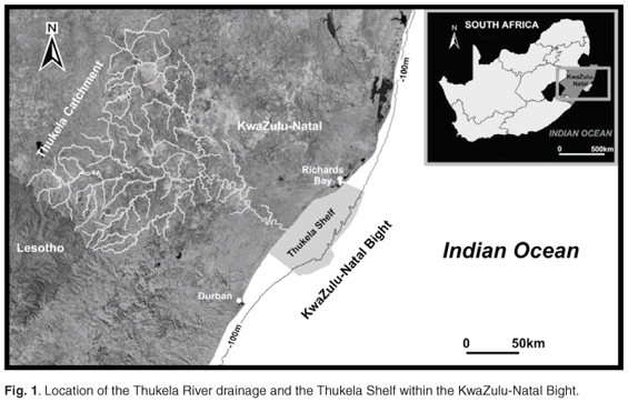
The subareal Thukela River delta is classified as wave-dominated with a marked asymmetry in which mouth bar sediments are reworked into an accretionary beachridge plain north of the river mouth.1,2 The subaqueous expression of this system has remained largely unknown, as few studies have been undertaken in the area except for the regional mapping programmes of the late 1970s and early 1980s.3–7 The study reported here, covering an area of approximately 100 km by 42 km (Fig. 1), developed out of the need to investigate the impacts that damming of the Thukela River may have on the Thukela Shelf.8,9 Over 140 surface grab samples,10 27 hammer cores and over 100 seismic line kilometres5,7 were used to generate a comprehensive bathymetric, sediment and sediment-thickness distribution map. Interpretation of the new data together with published and unpublished data were used to generate a sedimentological model of the Thukela Shelf that serves as an environmental support and management tool.
Regional setting
The Thukela drainage system (Fig. 1) and associated offshore sedimentary deposits have been active in shaping the continental margin and shelf of the eastern KwaZulu-Natal coast since the break-up of eastern Gondwana.11 Compared to most of the KwaZulu-Natal coast, which is characterized by a very narrow continental shelf (3–12 km), the Thukela Shelf is considerably wider, reaching a width of over 45 km (Fig. 1). This feature is the result of a structural offset ascribed to a change in tectonic origin of the margin from a sheared to a short-rifted section.12,13 The increased width of the shelf and the change in orientation of the coast relative to the southward-flowing Agulhas Current results in the generation of a semi-permanent gyre or cyclonic eddy centred over the Thukela Shelf.3,5,6,14,15 The gyre is fed by a high sediment input (6.79 × 10⁶ m3/yr) from the Thukela River (the third-largest river in southern Africa) and a further sediment source (1.0 × 10⁶ m3/yr16,17 or 0.85 × 10⁶ m3/yr18) from a northward-directed longshore drift produced by the dominant SE swell direction.7
Facies and facies association
Eight broad sedimentary facies types on the shelf are recognized; these can be grouped into four main facies associations, each of which can be assigned to particular sedimentary processes (Fig. 2; Table 1).


Inner shelf facies association
This facies association is dominated by fair-weather processes and consequently all deposition is above the fair-weather wave base (FWB). Observations from this study suggest that the FWB junction between the well-sorted, fine-grained sand (Facies 3) and the poorly-sorted sand (Facies 4) occurs at the 30-m isobath. Sedimentary cores of Facies 3 were composed of uniform, very well-sorted fine sand with no indication of upward fining. This supports the supposition that the Inner shelf is constantly being reworked by wave action and longshore currents.
Mid-shelf facies association
Cores taken from the Mid-shelf (Facies 4) are characterized by the presence of fining-upward sequences varying from 0.5 m to 3 m thick. Gravel or shell lags often form the scoured base of these units and together with the occurrence of large floating clasts, is indicative of tempestite, or storm-generated, density flows. In places, these fining-upward units are capped by a mud horizon which represents suspension settling of fluvially derived muds entrained in the gyre circulation during quiet periods. Mud beds range from 0.4 m to 1.5 m in thickness and are asymmetrically distributed on the Inner and Mid-shelf (Facies 2). In contrast, coarsening-upward units are occasionally present in Facies 4, which may also possess basal gravel lags. These gravel lag deposits probably represent the erosion surface over which a sedimentary bedform has migrated. The outer boundary of the Mid-shelf (–60 m) is characterized by a prominent semi-continuous palaeodune cordon and an associated increase in the shelf slope. It also marks the seaward margin of the Holocene sediment wedge, which represents the limit of modern terrestrial sediment deposition. The Holocene wedge is commonly banked against the palaeodune ridge, limiting cross-shelf sediment movement to the Outer shelf.3–7
Outer shelf facies association
Sediment dispersal and sedimentary processes on the Outer shelf (Facies 7) are dominated by the southerly-flowing Agulhas Current. Sediments are characterized by relict carbonate-rich gravels, sand ribbons and large, southerly-migrating bedforms.3–5 Due to strong current action, unconsolidated sediment is continuously moved over the edge of the shelf break and into submarine canyons, resulting in a sediment-starved Outer shelf.
Submarine delta association
The Thukela Shelf delta system comprises the Thukela mouth bar (Facies 1), Inner and Mid-shelf muds (Facies 2) and the sand-rich (Facies 5) and mud-rich (Facies 6) density flow deposits on the Mid- and Outer shelves, respectively. Facies 2 extends northward and turns cross shelf, forming an offshore loop (Fig. 2). Facies 5 bisects the Mid-shelf Facies 4 and continues as the offshore extension of the delta of the Mid- and Outer shelf muds (Facies 6). The latter is the distal expression of the Thukela delta. Although Facies 6 has previously been interpreted as a relict estuarine deposit,10 it is proposed here to represent deposition from density flows, probably originating from the Inner and Mid-shelf portions of the Thukela Shelf delta. The fact that Facies 6 (Outer shelf mud) has not been buried by gravel or bedforms of the Outer shelf (Facies 7) entrained within the Agulhas Current, is further evidence of its contemporary nature.
Mud is present in the study area as two separate facies (Facies 2 and 6) occurring as two distinct depocentres (Fig. 2). The Inner shelf mud (Facies 2) occurs in the inner and Mid-shelf regions and consists of an almost pure mud forming the well-known prawn-rich Thukela Mudbanks.9 In contrast, the Outer shelf mud (Facies 6) consists of a poorly sorted sandy mud occurring not only on the Outer shelf but extending beyond the shelf break (Fig. 2).
Discussion and conclusion
Sedimentological data were combined with shelf morphological and oceanographic data to construct an integrated environmental model for the Thukela Shelf (Fig. 3). The model emphasizes the uniqueness of the Thukela Shelf system and illustrates the inter-dependence of high sediment inputs, large shelf area and associated oceanographic complexities resulting in the development of an offshore sedimentary deposit with both deltaic and submarine fan characteristics. The deltaic components overprint the more typical Inner, Mid- and Outer shelf sedimentary facies (Facies 3, 4, 7). These sediments are reworked by wave action, longshore and gyre currents producing a northward-directed delta asymmetry (Figs 2, 3). Muds show the greatest northward transport as a buoyant plume within the KwaZulu-Natal Gyre, resulting in cross-shelf entrainment and deposition. Submarine fan-like deposits (Facies 5 and 6) represent cross-shelf density flows, generated at the delta front. These density flows are probably triggered by extreme events such as storms and floods. The facies association and distribution can be interpreted as a product of fair-weather/minor flood conditions punctuated by episodic extreme flood events.

During normal river flow and lesser floods, mud (Facies 2) is emplaced as flocculation deposits from buoyant freshwater plumes on the Inner shelf and Mid-shelf. Some of the plumes are entrained by the KwaZulu-Natal Gyre, resulting in a discontinuous semicircular depositional pattern (Fig. 3).
The mudbanks are unique on the southeast African shelf and used economically as prawn trawling grounds.9 The geographical pattern of the Inner shelf mudbank points to a deltaic origin, which echoes the KwaZulu-Natal Gyre and indicates that this oceanographic feature is a dominant control on the sedimentological processes. During extreme floods (>50-year RI), such as those of 1987 and 1925,19 large quantities of sediment are rapidly emplaced on the Thukela Shelf. The 1987 flood conveyed six times the annual average sediment discharge, all of which was deposited in a few days. We suggest, based on interpretation of the facies pattern, that during large storms the KwaZulu-Natal Gyre oceanographic pattern is disrupted and sediment is bypassed directly offshore. Density flows, originating on the Thukela River delta front, move sediment offshore onto the Outer shelf and over the shelf break. In the Flemming model,4,5 outer shelf sands are continuously moved southwards by the Agulhas Current. In this area, however, Thukela sediments overprint the Outer shelf facies. This provides further support for the contemporaneous deposition of the Outer shelf mud by density flows rather than representing a relic estuarine mud.10
We thank J.A.G. Cooper and anonymous referees for their advice on improving the manuscript. This research was funded by the Council for Geoscience as part of the programme to assess the influence of dams in the Thukela catchment on the continental shelf. Paul Young is thanked for reworking the GIS data.
1. Cooper J.A.G. (1990). Ephemeral stream-mouth bars at flood-breach river mouths: comparison with ebb-tidal deltas at barrier inlets. Mar. Geol. 95, 57–70. [ Links ]
2. Cooper J.A.G. (2002). The role of extreme floods in estuary-coastal behaviour: contrasts between river- and tide-dominated microtidal estuaries. Sediment. Geol. 150, 123–157. [ Links ]
3. Flemming B.W. (1978). Underwater sand dunes along the south-east African continental margin – observations and implications. Mar. Geol. 26, 177–198. [ Links ]
4. Flemming B.W. (1980). Sand transport and bedform patterns on the continental shelf between Durban and Port Elizabeth (southeast African continental margin). Mar. Geol. 26, 179–205. [ Links ]
5. Flemming B.W. (1981). Factors controlling shelf sediment dispersal along the southeast African margin. Mar. Geol. 42, 259–277. [ Links ]
6. Martin A.K. and Flemming B.W. (1986). The Holocene shelf sediment wedge off the south and east coast of South Africa. In Shelf Sands and Sandstones, eds R.J. Knight and J.R. McClean, Canadian Society of Petroleum Geologists, Memoir II, 27–44. [ Links ]
7. Birch G.F. (1996). Quaternary Sedimentation off the East Coast of Southern Africa (Cape Padrone to Cape Vidal), Bull. 118. Council for Geoscience, Pretoria. [ Links ]
8. Bosman C., Leuci R., Sinclair D. and Smith A.M. (2000). Geological model of the Thukela Shelf: Effects of damming the Thukela River, Report No. 2000-0011, Council for Geoscience, Pretoria. [ Links ]
9. Forbes A.T., Demetriades N.T., Bosman C., Leuci R., Sinclair D., Smith A.M., Fennessy S, Robertson, Sink K., Kruger A., Everett B.I., Fielding P.J. and Cilliers L. (2002). Impacts of proposed dams on the Thukela estuary and inshore marine environment, KwaZulu-Natal, South Africa. In African Basins: LOICZ Global Change Assessment and Synthesis of River Catchment Coastal Sea Interactions and Human Dimensions, eds R.S. Arthurton, H.H. Kremer, E. Odada, W. Salomons and J.I. Marshall Crossland, LOICZ Reports & Studies No. 25. LOICZ, Texel, the Netherlands. [ Links ]
10. Falhaber T.A. (1984). The geochemistry and sedimentology of Quaternary shelf sediments off the Tugela River, Natal, South Africa. PhD thesis, University of Cape Town, South Africa. [ Links ]
11. Dingle R.V. (1982). Continental margin subsidence: a comparison between the east and the west coasts of Africa. In Dynamics of Passive Margins, ed. R.A. Scruton, pp. 59–71. Am. Geophys. Un. Geodynamic Ser. [ Links ]
12. Martin A.K. (1984). Plate tectonic status and sedimentary basin infill of the Natal Valley (SW Indian Ocean). Bulletin Joint Geological Survey/University of Cape Town Marine Geoscience Unit, 4. [ Links ]
13. Martin A.K. and Flemming B.W. (1988). Physiography, structure, and geological evolution of the Natal continental shelf. In Coastal Ocean Studies off Natal, South Africa, ed. E.H. Schumann. [ Links ] Lecture Notes on Coastal and Estuarine Studies 26, 11–46. [ Links ]
14. Gründlingh M.L. and Pearce A.F. (1990). Frontal features of the Agulhas Current in the Natal Bight. S. Afr. Geog. J. 72, 11–14. [ Links ]
15. Gründlingh M.L. (1992). Agulhas Current meanders: review and case study. S. Afr. Geog. J. 74, 19–28. [ Links ]
16. Swart D.H. and Serdyn J. de V. (1981). Statistical analysis of visually observed wave data from voluntary observing ships for South African east coast. CSIR Report 9, Pretoria. [ Links ]
17. Nicholson J. (1983). Sedimentary aspects of the Mvumase Project. In Sandy Beaches as Ecosystems, eds A. McLachlan and T. Erasmus, pp. 191–197. W. Junk, the Hague. [ Links ]
18. Dunkley E., Schoonees J.S. and Theron A.K. (1998). Thukela Water Project: effects of a reduction in the Thukela River sediment yield on the adjacent coastline. CSIR Report (draft): ENV/S-C 98029. [ Links ]
19. Kovacs Z. (1989). Regional maximum flood peaks in Southern Africa. Department of Water Affairs, Technical Report 137, Pretoria. [ Links ]
Received 26 March. Accepted 14 November 2007.
* Author for correspondence. E-mail: bosman@ukzn.ac.za

