


Services on Demand
Article
 English (pdf)
 Article in xml format
 Article references
Indicators

Related links
-
 Cited by Google
 -
 Similars in Google
Share

 Permalink
South African Journal of Science
On-line version ISSN 1996-7489
Print version ISSN 0038-2353
S. Afr. j. sci. vol.103 n.11-12 Pretoria Nov./Dec. 2007
RESEARCH ARTICLE
What is an address in South Africa?
Serena CoetzeeI, *; Antony K. CooperII
IDepartment of Computer Science, University of Pretoria, Pretoria 0002, South Africa
IILogistics & Quantitative Methods, CSIR, P.O. Box 395, Pretoria 0001
ABSTRACT
Addresses come in many forms as they have a variety of uses. In this paper we illustrate the need for standardized addresses in South Africa by describing scenarios where they are required, or where standardized addresses would improve the current situation. We present the eleven address types described in the current draft South African address standard (SANS 1883), which has been developed under the auspices of the South African Bureau of Standards. We go on to show that these address types represent an all-encompassing description of an address in South Africa. The address types have to accommodate the current situation where there are no mandated authorities that assign standardized addresses according to a set of guidelines, and we provide a critical evaluation of this situation. Our contribution is threefold: it illustrates the need for standardized addresses, shows that there is an all-encompassing description for an address in South Africa, and describes the potential adverse effect of the current lack of mandated authorities on unambiguous address specification and the benefits that address standardization would bring.
Introduction
Standards South Africa, a division of the South African Bureau of Standards (SABS), began a project in 2004 to develop a South African National Standard (SANS) for 'a standard framework for South African addresses', subsequently given the designation SANS 1883. The aim of the standard is not to devise a new system of addressing or to build a national address database, but rather to enable interoperability in address data sets and geographical information systems (GISs), which will facilitate developing a national address database.1 SANS 1883 consists of three parts, all currently in working draft stage:
-
SANS/WD 1883-1, Geographic Information – Address Standard, Part 1: Data format of addresses.2
-
SANS/WD 1883-2, Geographic information – Guidelines for addresses in data bases, data transfer, exchange and interoperability.3
-
SANS/WD 1883-3, Geographic information – Guidelines for address allocation and updates.4
We present here examples illustrating the need for address standards in South Africa. The draft standard has now been completed, and we believe that it meets its aims.
The online version of the Compact Oxford English Dictionary defines an address as: the details of the place where someone lives or an organization is situated.5 An address is not only a set of directions for delivering post. SANS 1883-1 provides the following definitions:
Address: an unambiguous specification of a point of service delivery.
Point of service delivery (or service delivery point): actual location where a service could be provided.2
An address is therefore used to facilitate the delivery of one or more services by one or more providers. Service delivery includes anything from utility services such as water, sewerage, telecommunications and electricity supply; refuse collection; billing; postal and courier delivery; to emergency response; goods delivery; serving summonses; household surveys; and visiting. Addresses are also critical for services that are not necessarily performed at the address, such as opening bank accounts or buying on credit [as is required by the Financial Intelligence Centre Act (FICA)6]; obtaining an identity document or passport (as required by the Identification Act7); voting (the Electoral Act requires one to have an identity document to be registered as a voter8); obtaining employment (as illustrated by the tragic example of Kabelo Thibedi, who held hostage an employee of the Department of Home Affairs in Johannesburg on 30 November 2005, because he had been waiting for two years for his identity document, without which he could not get employment9); and for rates and taxes. As a result of apartheid, for many in South Africa, having an address has a social status, providing a sense of identity and of being recognized as a proper citizen.10
Addresses complement a land information system that maintains information about land parcels and associated legal interests in, and legal rights on, the land parcels. There is not necessarily a one-to-one relationship between a land parcel and an address: one land parcel could have many addresses and a number of land parcels could share the same address. In South Africa, a land parcel description consists of a land parcel number together with a registered name and registration division, and is recorded at a Surveyor-General's office. An address complements a land parcel description with information such as the street name and the street number, which are usually visible on or in the vicinity of the dwelling or building, while the land parcel description is not.
Addresses are not just for people, organizations (government departments, businesses, non-governmental organizations, etc.) or buildings (dwellings, offices, factories, etc.), however. They are also necessary for:
-
Undeveloped erven;
-
open spaces, such as parks;
-
crime or accident scenes, for directing emergency personnel accurately. For example, these addresses can be specified relative to a landmark, by giving the nearest street intersection, or as a specified distance in a specified direction along a linear feature, such as a road (that is, using a linear referencing system, for which the International Standard ISO 1914811 is currently being drawn up).
Addresses can therefore be permanent or transient. Coetzee and Cooper provide a more detailed discussion on the value of addresses to the economy, society and governance.10
The International Organization for Standardization's Technical Committee ISO/TC 211, Geographic information/Geomatics, has issued two international standards for spatial referencing, that is, for specifying where something is:
-
ISO 19111:2003, Geographic information – Spatial referencing by coordinates: this standard describes the structured metadata (that is, both human and computer readable) required for using coordinates, covering coordinate systems, coordinate reference systems and coordinate transformations, as well as types of coordinates.12
-
ISO 19112:2003, Geographic information – Spatial referencing by geographic identifiers: this standard describes how to link something to a location without explicitly using coordinates, but through a relationship to a location defined by a geographical feature (that is, something with a name or identifier). The standard does not consider the forms of the relationship, which could be containment (our point of interest lies within the feature), based on local measurements (that is, relative to the feature, for instance, a specified distance along a street from an intersection), or loosely related, where the position has a fuzzy relationship with the feature (such as behind a building).13
There have been several attempts over the years to develop a universal addressing system based on geographical coordinates (latitude and longitude), such as the .geo Internet top level domain (TLD) applied for by SRI International14 as part of the generic TLD expansion during 2000. The Internet Corporation for Assigned Names and Numbers (ICANN) rejected the application and SRI's reconsideration request because of 'the difficulty of defining the market and whether the market will accept this new service', amongst other reasons.14,15 Unfortunately, even with the widespread and growing use of global positioning system (GPS) devices by the general public,16 and even with the availability of virtual globes such as Google Earth17 or NASA World Wind,18 coordinates are difficult for humans to use for addressing.19 Hence, while computers 'prefer' addresses expressed as coordinates, for human use, an address should be a form of spatial referencing by geographic identifiers, that is, containing intelligible names and context, such as a hierarchy of names (such as street, suburb, town, province and country).
Another standard developed by ISO/TC211, ISO 19133:2005 – Geographic information – Location based services – Tracking and navigation, includes a tentative address model which is one way of describing locations for use in location-based services. This model describes an address as an aggregation of address elements, but does not prescribe a specific order for the elements, nor does it prescribe valid aggregations of address elements. ISO 19133 defines eight address elements: a street, a street intersection, a street address, a street location, an addressee, a phone number, a postal code, and a named place.20
Other national standards bodies that have produced address standards are the British Standards Institution (BSI),21–24 the Federal Geographic Data Committee (FGDC in the US),25 the European Committee for Standardization (CEN),26 and the councils of standards of Australia and New Zealand.27 The Universal Postal Union (UPU)28 has published an international standard on postal address components and templates. The standards from the UPU and CEN focus narrowly on postal addresses and the formatting of addresses on envelopes, whereas the need in South Africa is broader, particularly for the delivery of utilities. The British, American, Australian and New Zealand standards provided good reference material for the South African address standard, but each standard was written for the specific address requirements of that country, and none of them provided for the wide variety of address usage in South Africa.
The objective and contributions of this paper are to: 1) illustrate the need for standardized addresses; 2) show that the current draft South African address standard (SANS 1883) provides an all-encompassing description for an address in this country; and 3) evaluate critically the current situation in relation to address standards in South Africa.
The need for standardized addresses
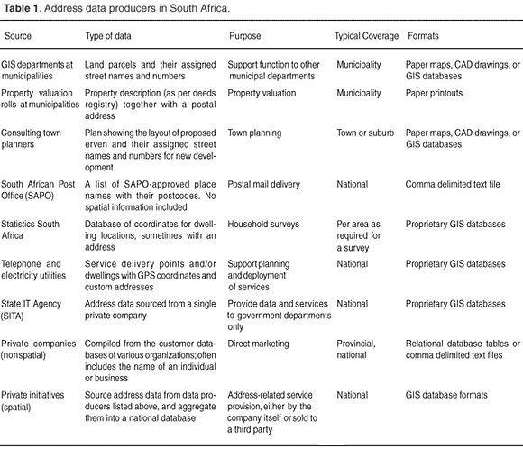
In the introduction we described the wide range of uses of addresses and that if, for example, a bank wants to establish proof of residence electronically, an address database of national coverage is required. We also emphasized the need for addresses in the broader sense, that is, not only for postal delivery. A single official national address database for South Africa currently does not exist. There are, however, organizations such as the Independent Electoral Commission (IEC), Statistics South Africa and spatial data vendors (AfriGIS and Knowledge Factory), who have collated address data from numerous producers to establish their own databases with national coverage, though none of them is complete. Table 1 lists some of the address data producers in South Africa. The wide range of purposes results in many different formats and types of address data being produced. These organizations have often allocated their addresses according to their own addressing scheme to dwellings independently (and often painted them on, as well), particularly in rural areas. To collate a national address database, the data from the various sources have to be harmonized syntactically and semantically. First, the data have to be converted into a common format (columns and data types) – this is being addressed by SANS 1883. The most common semantic problem is which name is preferred, such as whether the colloquial or registered suburb name should be used (for example, Pretoriuspark Extensions 1, 6 and 8 in the City of Tshwane are much better known by their colloquial name, Woodhill). Names of areas are sometimes politically sensitive in South Africa. Matheri29 describes more of the semantic challenges in standardizing an address system in this country. An address standard, such as SANS 1883, that is used by all address data producers, would make the collation of a national address database easier. While such a standard can be prescriptive about the syntax of address data (as SANS 1883-1 is), however, it can provide only guidelines about the semantics of address data (as SANS 1883-2 and SANS 1883-3 do).
SANS 1883-1 and SANS 1883-3 also provide definitions for addresses and address-related terminology, establishing a common vocabulary for addresses and therefore improving the understanding of what an address in South Africa is.
An address is one of the oldest and most common instruments used to find a location.30,31 The addressing system in itself represents a spatial reference system using geographical identifiers (as opposed to coordinates) that allows one to find one's way and to navigate to locations on the Earth's surface. Thus, address data are reference data, whose importance is confirmed in the INSPIRE directive, which prioritizes address data as one of the basic spatial building blocks required for a spatial data infrastructure.32
Turning descriptive location information such as an address into an absolute geographic coordinate is generally referred to as geocoding. Geocoding is widely used in industry, for example, to enable spatial analysis of a customer base in relation to outlet planning or marketing campaigns, as well as in the public sector, for instance, to ensure that the locations of voting stations meet the legislated requirements of capacity and proximity to the voters. Geocoding large data sets of customers or voters is a process that has to be automated, and automation in turn requires the input addresses to be standardized. Goldberg et al.33 describe the problems associated with geocoding non-standardized addresses.
The South African Bureau of Standards, through Standards South Africa (StanSA), prepares and publishes South African National Standards, identified by the letters SANS. These standards reflect national consensus on a wide range of subjects, and are aimed at improving the quality of life of all South Africans. The standards are drawn up by experts in the field from across government, industry and academia, working through StanSA technical committees (TCs) and sub-committees (SCs). StanSA SC 71E, Geographic Information, deals with standards for geographic information for South Africa.
In August 2004, SC 71E voted for a new work item proposal on 'A standard framework for South African addresses', subsequently given the designation SANS 1883. It was decided that the standard should support:
1) The allocation and management of addresses; 2) the recording and interchange of addresses; 3) the geocoding and spatial representation of addresses; 4) the delivery of services throughout South Africa; and 5) the national developmental objectives.
The aim of the address standard is not to devise a new system of addressing or to build a national address database, but rather to enable interoperability in address data sets, which will facilitate developing a national address database. Since there is no current ISO address standard, a South African project team was established in June 2006 to prepare SANS 1883, which has three parts, all currently in working draft form:
SANS/WD 1883-1, Geographic Information – Address Standard, Part 1: Data format of addresses (draft).2
SANS/WD 1883-2, Geographic information – Guidelines for addresses in data bases, data transfer, exchange and interoperability (draft).3
SANS/WD 1883-3, Geographic information – Guidelines for address allocation and updates (draft).4
The fact that we need standardized addresses in South Africa is further confirmed by the widespread and active participation in the SANS 1883 project meetings, from June 2006 to July 2007. More than thirty organizations have been represented, including national departments, municipalities, parastatal organizations as well as the private sector. Others have provided inputs via correspondence.
In summary, standardized addresses and related standardized address data are required to
-
establish a common vocabulary for addresses that eliminates ambiguities and misunderstandings both in address data maintenance as well as in day-to-day communication, for example, when giving directions;
-
fast-track the assignment of addresses in previously unaddressed areas such as rural villages. Address standardization will enable consultants to reuse address-related tools at more than one local authority, and will encourage the development of open source tools for address management;
-
assist local authorities in controlling addresses that are assigned by private property developers;
-
enable address data interoperability, which in turn makes the exchange of address data possible and facilitates the collation of address data into larger databases such as a provincial or national address database;
-
improve the process of geocoding. The first step in the geocoding process involves the structuring of the address into its individual address components, so that it can be matched against a reference data set. If an address is already structured according to a standard, this step can be eliminated whereby the geocoding uncertainty factor is reduced.30
An all-encompassing description for an address in South Africa
Different approaches to addresses
There have long been two approaches to addresses in South Africa, each with a different focus on the address. On the one hand, traditional GIS departments and GIS service providers work with spatial address databases, integrate these with land administration and use them for mapping. The focus here is on the address and its location. On the other hand, customer-related business services focus on a customer, and one of a customer's attributes happens to be an address, used primarily for correspondence. The physical location of the customer's address or the fact that the customer's address could have a geographic coordinate is an afterthought that becomes important only when the customer's address is geocoded. The difference in focus is illustrated, for example, in the data model that is used to maintain the address data. In a spatial address database the suburb and street names are maintained in two different layers, each with its own geometries and attributes. This is clearly illustrated in the spatial data that are made available by municipalities such as the City of Tshwane,34 City of Johannesburg35 and City of Cape Town36 on their respective official websites. On the other hand, a customer address is stored as several address line fields, with no structure to the content of the address (except, perhaps, for the postcode). This approach is illustrated in the tool that the SA Post Office makes available to Postal Address Management Service Suppliers (PAMSS): the tool reads addresses that consist of an address reference, any number of address lines and a postcode. The suburb and street information of the address can appear arbitrarily in any of the address lines. The first author has also seen this approach in the customer databases of several South African corporate databases. Examples of these two approaches are given in Fig. 1.
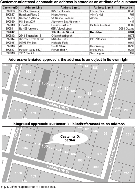
These different ways of storing addresses complicate interoperability between addresses. Lind37 describes other drawbacks of the customer-orientated tabular approach: '...it is difficult to control individual address information because each instance of address information is treated individually.' For example, if an address is treated as an attribute of a customer, the address of each individual customer has to be maintained. This implies that a suburb name change requires an update of each individual customer record whose address falls in that suburb. If the customer is linked to an address object, a suburb name is changed once only. The name change is automatically reflected in the addresses that are linked to that suburb and the customers that are linked to addresses in that suburb. A result is that address fields get included in databases differently – for example, in the database of one large South African organization, the name of the town Witbank was recorded in the field for town names in over 200 different ways.38
Lind goes on to describe the Danish conceptual address data model, in which a customer is linked to an address object, rather than carrying the address as attributes. In the Danish address model the address-orientated and customer-orientated approaches are integrated. Recently published research by Clodoveu and Fonseca30 confirms Lind's statement in their conclusion that 'Addresses cannot be considered as mere attributes of buildings or of traffic accidents. Addresses are entities in themselves in the modeling level and in the conceptual level.'
In South Africa, as with the rest of the world, the growing number of spatial analyses conducted on customer databases; the increase in every day use of spatial addresses, such as in-vehicle navigation, and location-based services as well as address verification based on geographic coordinates; call for the integration of the two approaches to address management. It is therefore significant that the development of the South African address standard includes representation from organizations with both address-orientated and customer-orientated approaches. Further, the address types presented below conform to a data model in which an address is treated as an individual object to which a customer is linked.
The eleven address types in SANS 1883-1
The draft South African address standard (SANS 1883) has drawn from similar standards elsewhere and the widespread expertise of its project members to describe the plethora of address types used in South Africa. The current draft standard includes eleven types of addresses: a street address, a building address, an intersection address, a site address, four types of SA Post Office addresses, a landmark address, a farm address, and an informal address. The following paragraphs describe each one of the address types, and list a few examples. It must be emphasized that SANS 1883-1 aims at documenting all forms of addresses used in South Africa, rather than prescribing a narrow set of addresses that shall be used. SANS 1883-3 provides guidelines on which types of addresses should preferably be used, and how they should be allocated.
Street address. In its most basic form the street address consists of a street name and a locality. An indication of street numbering is optional, that is, the 1736 in 1736 Pretorius Street is optional or the 938B in 938B Nelson Mandela Drive is optional. The locality can include suburb, town, municipal, provincial and country names. The inclusion of a postcode is optional.
| Dr Lategan Road, Groenkloof |
Intersection address. This address type describes a location at the corner of two intersecting streets without any street number information.
| Corner of Mulders Mile and Swart Street, Eldoraigne |
Landmark address. In some instances the name of a landmark together with a locality is enough to be an unambiguous description of the location. The landmark address type provides for these addresses. Note that it does not always include street information.
| Parliament, Cape Town |
Building address. This is a composite address type that consists of building information (in italics in the examples below) together with a street identifier or intersection identifier. The building information comprises unit and floor information together with a unique building identifier. Provision is made for a number of buildings that are grouped together and referred to by a common name, such as the complex's name.
| Block 816 Diamond House, Eloff Street, Braamfontein |
Site address. The address types described above include either a street name or a landmark name in the address. In South Africa, however, there are addresses (unambiguous descriptions of service delivery points) that consist of an address number and locality only. Site addresses occur primarily in townships established during the apartheid years, when house numbers were allocated per block or section in a township, but no street names were assigned. Today there is a big drive by municipalities in South Africa to assign street names in the former townships.
Unfortunately, it is a slow process because of sensitivity over names and the need for community participation, and site addresses in townships will continue to exist in the foreseeable future.
The second type of a site address occurs in rural areas and describes the location of a farm or agricultural holding by referring to the Surveyor-General's cadastral description of the property.
The third type of a site address is quite recent, and occurs in security estates where the property is described by means of a cadastral erf number together with a name for the locality. In this case, the locality name is not necessarily the same as the name registered at the Surveyor-General (that is, the official name), but is assigned and used by the property developer of the estate, and then becomes the de facto name for the area.
| 25436 Soshanguve CC (former township) |
Farm address. A farm address consists of a farm name (in italics in the examples below), which is assigned by the occupant or owner of the farm, together w ith a town or colloquial area name. The farm address also provides for an optional building name, similar to the building name in the building address type, which identifies either the specific dwelling of a tenant or another structure on the farm that acts as a service delivery point.
| My Geluk, S935, opposite farm dam, Koffiefontein, Letsemeng Local |
Informal address. Delegates to the SANS 1883 project meetings provided various examples of the use of descriptive free format text addresses, such as a cell-phone service provider delivering a pre-paid voucher to an address of the form: 'Under the tree at the entrance to the village of Feni'. This kind of address also has to be stored in a database, and the informal address type provides for these addresses. The minimum requirements for an informal address are a free format description together with a locality. The address type provides for optional street, street intersection or landmark information. Although this address type is useful for data exchange, official allocation of informal addresses is not encouraged.
| First house on the right after the Vodacom booth, Olievenhoutbosch |
SA Post Office address types. The SA Post Office specifies four address types for postal mail delivery: the P.O. Box address, street address, poste restante address, and the SAPO-type rural village address. These address types are also recognized by the Postal Address Management Service Suppliers (PAMSS), who are accredited by the SA Post office to certify addresses for bulk mailing (a considerable rebate on postage applies to PAMSS-certified addresses).
SAPO box address. This consists of a P.O. Box or Private Bag description together with a post office name and postcode. The country name or code is optional. Below are some examples.
| P.O. Box 2947, Hatfield, 0028, ZA |
SAPO street address. The three addresses below represent street addresses as used for delivery by the SA Post Office. There are two subtle differences between the street address type described earlier and this Post Office street address type:
1. The postcode is mandatory in the Post Office street address type, whereas in the street address type the postcode is optional.
2. The locality name in the Post Office street address type has to be one of the names as provided by the Post Office. This locality name refers either to a place name or a post office name, whereas in the street address type the locality name always refers to a place name. The street address type also provides for colloquial place names, whereas the locality name in the SA Post office street address is restricted to names approved by the Post Office.
The Post Office street address type is not a subset of the street address type, because a Post Office name is not allowed in the street address type.
| 74 Observatory Road, Woodhill, 0081 |
SAPO poste restante address. This is a service whereby a post office holds mail for a limited period, to be collected by the addressee in person from the post office. Internationally, this is typically used for visitors who do not know in advance where they will be staying. It is also used in South Africa and other countries by people who have not yet been assigned a postal address. The poste restante address must include the full name of the recipient (to be matched against their identification document or passport), together with the post office and postcode. The sender should also include their return address, but that appears elsewhere on the envelope and does not form part of this address type.
| Mr Peter Smith, Poste Restante, Pretoria, 0001, South Africa |
SAPO-type village address. Finally, the Post Office-type village address consists of a house number together with an optional village name, and a mandatory place name and postcode. The house number consists of three pairs of digits, identifying (from left to right) the village, section and dwelling (Fig. 2). The place name and postcode refer to the post office closest to the village.

The Post Office has been assigning these addresses to dwellings in rural villages, thereby making a significant contribution to the development of the people in these areas by enabling them to receive mail, furniture and other goods or service deliveries. It also enables a person to apply for financial services for which a residential address is required according to the Financial Intelligence Centre Act.
| 012151 Ngxingxolo, Mooiplaas, 5228 |
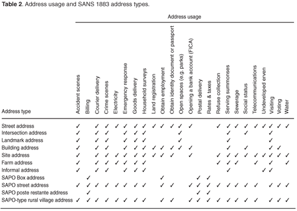
In summary, these address types cater for all the different address usages that were discussed in the Introduction, and Table 2 illustrates this. The longitude and latitude attributes that are optional parts of each address record, as per SANS 1883-1, provide for an integrated approach to address data. SANS 1883-1 also includes the mandatory Point of Observation attribute to specify where the longitude and latitude were recorded, for example, centre of land parcel.
Critical evaluation of addresses in South Africa
In this section we provide a critical evaluation of the address situation in South Africa to show how the lack of mandated authorities impacts on address standardization.
An assessment of the eleven address types in SANS 1883-1
Two of the SA Post Office address types are well known and widely used in South Africa, and conform to the international postal address standard (UPU S2428), namely the SAPO box address and the SAPO street address. A third, the SAPO poste restante address, is used around the world, though it is perhaps not that well known in South Africa. Four address types are widely used for giving directions, namely: street address, intersection address, landmark address and building address. A concern with these four is that they often contain components that are not formally recorded with the relevant authorities, such as street names in private estates. The remaining four types are considered in more detail:
-
Site address: the use of site addresses for townships is an unfortunate legacy of apartheid, but they are being replaced by the two types of street addresses, which should facilitate navigating around these townships, if nothing else. The same goes for site addresses that were assigned by multiple service providers in the past. The rural address expansion project led by the Post Office aims to replace these addresses with their formal system of SAPO-type village addresses. The security estate site addresses are of concern, though, because they are not assigned by an appropriate authority and hence are probably not included in reference databases used in terms of FICA, for example.
-
Farm address: as with security estate site addresses, these are of concern when not assigned by an appropriate authority, and changed at whim. This is of particular concern with directing emergency services, because of the size of farms and uncertainty over which roads actually provide access to the farm.
-
Informal address: these addresses are common in many other African countries, as well. With the naming of streets and the SA Post Office's Rural Address Expansion Project, for providing formal addresses to all,39 the need to cater for informal addresses will diminish rapidly, and will, one hopes, be eliminated in a few years.
-
SAPO-type village address: a key aspect of these addresses is that the SA Post Office employs an addressing agent in each village, appointed from the community, who captures details of all the dwellings, together with empty stands and planned future expansion.39 A concern with any fixed-width hierarchical numbering system is that a field (village, section or dwelling) will run out of capacity. The villages are numbered relative to the post office that serves them, however, and the SA Post Office will build an additional post office well before one post office services 99 villages. Finally, before villages get large enough to have many sections, they are likely to have formal streets laid out and change to using street addressing.
Cause for ambiguities in the locality part of addresses
The address types described above are made up from various data elements, such as the street number, street name, building information, and the locality reference. Table 3 shows the data elements comprising the street and building address type, as well as the data elements comprising the SAPO street address type. The letters 'M' and 'O' indicate whether the element is mandatory or optional for that address type.
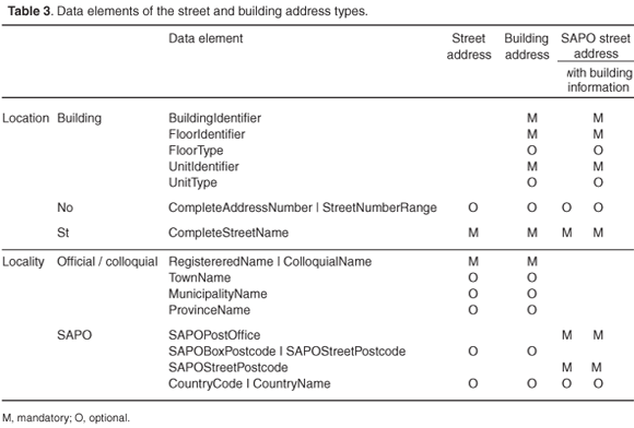
The table shows that the location part of the street address type and the SAPO street address type are identical, but that the locality part differs. Similarly, the building address type and the SAPO street address type with building information differ only in the locality part of the address. This creates ambiguity in that the following two addresses refer to the same place (or service delivery point):
| 546 Puccini Street, Constantia Park |
Another cause for ambiguity is property developers who market and sell property in security estates under a different name from the registered name. The Centurion Golf Estate and Woodhill in the City of Tshwane Metropolitan Municipality are examples of these. The Centurion Golf Estate is registered at the Surveyor-General's office as Highveld Extensions 7 and 10, whereas Woodhill is registered as Pretoriuspark Extensions 1, 6 and 8. This results in the following pairs of ambiguous addresses:
| 84 Santa Monica Boulevard, Highveld Extension 7 |
A recent study in Denmark analysed the qualitative and quantitative impact of address ambiguities. The qualitative analysis confirmed that the ambiguities affect people every day, sometimes even resulting in life-threatening situations. The quantitative analysis showed that the costs of the process of renaming streets is covered in the long term by the saving of not having ambiguities. A Danish statutory order now prohibits address ambiguities.40
To what extent can ambiguities be allowed? Should the authorities compel property developers to register formally any new name that they wish to use for an area? The truth is that we will never get rid of all the ambiguities because suburb or place name boundaries are not the type of boundary to be physically fenced off and hence obvious for all to see. There is always the human ego factor that sees a person, living near the boundary of a more prestigious suburb, use the name of that suburb in their address. Reducing the causes for ambiguity, however, such as having one set of official place name boundaries for the country, will limit the number of ambiguities, and thereby minimize the effort and money lost on clarifying ambiguous addresses.
Lack of an official address register
South Africa does not have an official national address register, and this has implications for the availability of address data. First, it means that there is no official national master database of valid addresses for the country. Even though there are address databases, some in the public and others in the private sector, none of the providers of these databases has been given a mandate to provide an official register of addresses. The Geographic Names Council (GNC) is responsible for standardizing place names in South Africa, and in this capacity the GNC has delegated the responsibility for allocating addresses to the municipalities. Even though municipalities assign official names to suburbs, however, a property developer can still choose to use a different name for the area, as we illustrated above with the Centurion Golf Estate and Woodhill.
Eventually, these colloquial names become widely known while the use of the official name disappears. The question is whether this should be allowed. How can an address be verified if it does not include the official names of the street and suburb as allocated by the local municipality?
In some instances, the roads inside a security estate are owned and maintained by a Section 21 company (sometimes known as a home owners' association) and not by the local municipality. For this reason, the local municipality is not responsible for assigning street names and street numbers inside the security estate and therefore these addresses are not necessarily part of the municipal address database. If a person inside such a security estate wants to open a financial account, how can one verify that their address is valid?
A similar situation exists in rural areas, where the current owner of a farm is free to use whatever name he/she choses for the farm, on a sign posted at its entrance. If the owner is free to change the name on the sign post at will, is it ever really possible to verify the validity of a farm address? This also creates problems with delivering services, such as emergency response.
Then there is a plethora of rural villages in South Africa. The SA Post Office has embarked on a commendable project to provide addresses for all the dwellings in these rural villages, and the format of these addresses is described by the SA Post Office-type rural address type in SANS 1883-1. The SA Post Office currently assigns these addresses in consultation with the local tribal authorities and local SAPO agents, appointed in consultation with the local tribal authorities. Not all of these addresses are stored in a database yet, however, and many of the addresses have not been geocoded. The primary reason for this is the substantial costs involved in capturing and maintaining reliable geocoded data. And if the rural village address is not part of some kind of database, how does one verify it to be valid?
Address duplication
Another implication of not having a national address register is that a huge amount of duplication takes place. This duplication comes in the form of address assignment as well as address data maintenance.
Some utilities and government departments needed to roll out services to areas before formal addresses had been assigned, with the result that these organizations devised their own addressing schemes. Further, they often painted their identifiers on the dwellings and any one dwelling could end up having several identifiers painted on it by different organizations.39 Multiple addresses were therefore assigned to the same dwelling.
The Independent Electoral Commission has completed a national address database that is used solely for managing elections. At the same time, private sector companies have realized the business opportunity of providing a national address database to corporate organizations, such as the major banks. Several national address databases therefore exist and are maintained in parallel, and one could well ask whether the taxpayers' money would not be better spent if the money was pooled and spent on a single national address database. These duplicate national address databases also create different versions of the truth, contributing to the address ambiguities described in the previous section.
The price tag attached to obtaining a national address database prohibits all but the larger organizations from access to it. This is because of the substantial costs in maintaining address data which private sector companies have to recoup from sales. As address data are reference material that is commonly used to cite locations, service providers in both the public and the private sectors would greatly benefit from having access to a national address register that is available free of charge, or at least at a much lower cost than now. Such access would enable service providers to design, develop, maintain and improve services to all locations that are referenced by an address.
Address backlog
Formal addresses have never been assigned in vast areas of South Africa. These areas include farms, rural villages and former black townships. Prior to the 2001 demarcation of municipalities, urban and rural areas were governed by different types of local government. Since 2001, however, the municipalities cover the whole of South Africa and each is responsible for service delivery in both the urban and rural areas under its jurisdiction. Municipalities are responsible also for address assignment in previously unaddressed areas.
As there is no single national address database with complete coverage, it is difficult to estimate how many addresses there are in South Africa, and even more difficult to calculate how big the backlog is. According to Census 2001,41 there are around eleven million households in South Africa, but there is not necessarily a one-to-one relationship between a household and an address, as more than one household could be living at the same address (such as in a garden flat) and a household could have more than one address (think of parliamentarians living in Cape Town and their home towns). The digital cadastre of the country records approximately seven million land parcels, but again there is no one-to-one relationship because not all erven are residential and, for example, a communal land parcel could have multiple dwellings on it. A further 500 000 sectional-title properties recorded at the deeds registry brings the total to 7.5 million properties, excluding communal land. Based on these figures, a very crude estimate is that there are between 7.5 million and 11 million addresses in South Africa (excluding P.O. box addresses). The largest address databases in the country currently have between 3.5 million and 5 million addresses, implying the backlog in addresses is somewhere between 4 million and 6 million, that is, around 50%. This is arguably a very crude estimate but it does illustrate that the backlog is substantial.
Address standardization will fast-track the assignment of addresses in previously unaddressed areas for various reasons: service providers to local authorities will be able to reuse address-related tools at more than one local authority; the development of open-source tools for address assignment and maintenance will be encouraged; and in general the process for address assignment and maintenance will converge, resulting in an increasing pool of people with similar skills in assigning and maintaining addresses. Address standardization further assists local authorities in prescribing and controlling the assignment of addresses by private property developers.
Conclusion
We have shown what an address is and where addresses are used in South Africa. We have discussed the need for standardization of address data, and described the origin of the national address standard (SANS 1883). We further described the address types of the newly drafted South African address standard and showed that they cater for the range of uses of address data in this country, and also provide for an integrated approach to address data management. Thus, SANS 1883 provides an all-encompassing description for an address in South Africa. In our critical evaluation of addresses we highlighted current causes for ambiguities in addresses, and described solutions for reducing these causes, such as having a single set of official place name boundaries for the country, and mandating certain authorities to assign addresses. We have also given various reasons why South Africa would benefit from a government-sponsored official national address register.
In summary, therefore, we have shown that SANS 1883 for the first time provides an all-encompassing description of an address in South Africa. Standardizing addresses according to SANS 1883 will
-
establish a common vocabulary for addresses;
-
fast-track the assignment of addresses in previously unaddressed areas;
-
assist local authorities in prescribing and controlling address assignment;
-
enable address data interoperability and facilitate collation of address data; and
-
improve the process of geocoding.
Although the three parts of SANS 1883, Geographic Information – Address Standard, have been completed, they still need to be taken through the formal adoption process for a national standard, and then implemented. Hence, there is scope for assessing the effectiveness of the standard, its dissemination and implementation, and for proposing amendments to improve SANS 1883. The standard will enable the development of software tools for parsing addresses and verifying their syntax, and possibly also for correcting errors in address data.
Future research on the social implications of SANS 1883, on the placing of legal restrictions on the creation of new addresses (to reduce ambiguity), and the manipulation of South African address data for address verification and geocoding would further enhance the understanding of the implications of address standardization. Finally, the applicability of SANS 1883 to other countries, specifically in Africa, could be explored.
We wish to acknowledge the useful feedback we received from anonymous referees. We would like to thank the SABS for initiating the project for the South African address standard (SANS 1883), and for allowing us to report on it here. We would also like to thank all delegates to the project meetings for their contributions and active participation in developing the draft standard, and also those who provided inputs via correspondence.
1. Coetzee S. (2006). Address standard for South Africa, PositionIT, Sept/Oct 2006. [ Links ]
2. SANS/WD 1883-1 (2003). Geographic Information – Address Standard, Part 1: Data format of addresses (draft). Standards South Africa, Pretoria. [ Links ]
3. SANS/WD 1883-2 (2003). Geographic information – Address Standard, Part 2: Guidelines for addresses in data bases, data transfer, exchange and interoperability (draft). Standards South Africa, Pretoria. [ Links ]
4. SANS/WD 1883-3 (2003). Geographic information – Address Standard, Part 3: Guidelines for address allocation and updates (draft). Standards South Africa, Pretoria. [ Links ]
5. Oxford University Press (2007). Online edition of the Compact Oxford English Dictionary. Online: http://www.askoxford.com/concise_oed/address?view=uk [ Links ]
6. Financial Intelligence Centre Act, No. 38 of 2001 (South Africa). Online at: www.info.gov.za/documents/acts/2001.htm [ Links ]
7. Identification Act, No. 68 of 1997 (South Africa). Online at: www.home-affairs. gov.za/documents/act68.pdf [ Links ]
8. Electoral Act, No. 73 of 1998 (South Africa). Online at: www.info.gov.za/gazette/ acts/1998/act73-98.htm [ Links ]
9. Sukhraj P., Mashego M., Maphumulo S., Molosankwe B. and Quintal A. (2005). ID delay drives man to take a hostage, Independent Online at: www.iol.co.za/ index.php?click_id=13&set_id=1&art_id=vn20051201070030492C6485471 (accessed December 2005). [ Links ]
10. Coetzee S. and Cooper A.K. (2007). The value of addresses to the economy, society and governance – a South African perspective, 45th Annual URISA Conference, 20-23 August 2007, Washington D.C. [ Links ]
11. ISO 19148, Geographic information - Location Based Services - Linear Referencing System (draft). [ Links ]
12. ISO 19111:2003, Geographic information – Spatial referencing by coordinates. [ Links ]
13. ISO 19112:2003, Geographic information – Spatial referencing by geographic identifiers. [ Links ]
14. SRI International (2000). The Proposed .geo Top-Level Domain Name. Online at: http://www.ai.sri.com/dotgeo/ [ Links ]
15. ICANN (2000). Summary of Application: .geo application by SRI International. Online at: www.icann.org/tlds/report/geo1.html [ Links ]
16. Braunschvig D., Garwin R.L. and Marwell J.C. (2003). Space Diplomacy. Foreign Affairs 82: 156–164. [ Links ]
17. Google Earth: Explore, Search and Discover. Online at: http://earth.google. com/ (retrieved 11 July 2007) [ Links ]
18. NASA Learning Technologies: World Wind 1.4. Online at: http://worldwind. arc.nasa.gov/ [ Links ]
19. Sorvari A., Jalkanen J., Jokela R., Black A., Koli K., Moberg M. & Keinonen T. (2004). Usability issues in utilizing context metadata in content management of mobile devices, Proc. Third Nordic Conference on Human-computer Interaction, Tampere, Finland. ACM International Conference Proceeding Series, vol. 82, 357–363. [ Links ]
20. ISO 19133:2005, Geographic information – Location based services – Tracking and navigation. [ Links ]
21. BS 7666-0:2006, Spatial data sets for geographical referencing. General model for gazetteers and spatial referencing. British Standards Institution, London. [ Links ]
22. BS7666-1:2006, Spatial data sets for geographical referencing. Specification for a street gazetteer. British Standards Institution, London. [ Links ]
23. BS7666-2:2006, Spatial data sets for geographical referencing. Specification for a land and property gazetteer. British Standards Institution, London. [ Links ]
24. BS7666-5:2006, Spatial data sets for geographical referencing. Specification for a delivery point gazetteer. British Standards Institution, London. [ Links ]
25. Federal Geographic Data Committee (FGDC) (2005). Street Address Data Standard (working draft). US Geological Survey, Reston, VA. [ Links ]
26. EN 14142-1:2003, Postal services – Address databases – Part 1: Components of postal addresses. European Committee for Standardization (CEN), Brussels. [ Links ]
27. AS/NZS: 4819:2003, Geographic information – rural and urban addressing. Jointly published by Standards Australia, Sydney, and Standards New Zealand, Wellington. [ Links ]
28. Universal Postal Union (UPU) (2006). S42: International postal address components and templates. UPU, Berne. [ Links ]
29. Matheri M. (2005). Challenges facing the creation of a standard South African address system, FIG Working Week and 8th Global Spatial Data Infrastructure Conference (GSDI-8), Cairo, 16-21 April. [ Links ]
30. Clodoveu A.D. Jr and Fonseca T. (2007), Assessing the certainty of locations produced by an address geocoding system. Geoinformatica, 11: 103-129. [ Links ]
31. Reference data and metadata working group (2002). INSPIRE - Reference data and metadata position paper. EURSTAT, available online at www.ec-gis.org/ inspire/reports/position_papers/inspire_rdm_pp_v4_3_en.pdf [ Links ]
32. Directive 2007/2/EC of the European Parliament and of the Council of 14 March 2007 establishing an Infrastructure for Spatial Information in the European Community (INSPIRE) [2007] OJ l 108/1. Online at: http://inspire.jrc.it/directive/ l_10820070425en00010014.pdf [ Links ]
33. Goldberg D.W., Wilson J.P. and Knoblock C.A. (2007). From text to geographic coordinates: the current state of geocoding. URISA Journal 19, 33–47. [ Links ]
34. City of Tshwane web site, www.tshwane.gov.za [ Links ]
35. City of Johannesburg website, www.joburg.gov.za [ Links ]
36. City of Cape Town website, www.capetown.gov.za [ Links ]
37. Lind M. (2004). Reliable address data: developing a common address reference system. In Compendium of SDI Best Practice, Section 6.1. GINIE Report, 2 October, online at: www.ec-gis.org/ginie/ [ Links ]
38. Cooper A.K. (2007). Participation in the development of standards in ISO/TC 211, CODI V pre-conference workshop on the development of an African Metadata Profile, Addis Ababa, 30 April. [ Links ]
39. Rossouw P. and Kgope K. (2007). South African Post Office Rural addressing in South Africa, PositionIT Sept/Oct 2007, pp. 66-71. [ Links ]
40. Lind M. (2007). Benefits of common address data – experiences and assessments, 45th Annual URISA Conference, 20-23 August 2007, Washington D.C. [ Links ]
41. Statistics South Africa (2003). Census 2001 – Census in brief. Pretoria. [ Links ]
Received 14 August. Accepted 14 October 2007.
* Author for correspondence. E-mail: scoetzee@cs.up.ac.za

