Servicios Personalizados
Articulo
 Inglés (pdf)
 Articulo en XML
 Referencias del artículo
Indicadores

Links relacionados
-
 Citado por Google
 -
 Similares en Google
Compartir

 Permalink
South African Journal of Science
versión On-line ISSN 1996-7489
versión impresa ISSN 0038-2353
S. Afr. j. sci. vol.103 no.11-12 Pretoria nov./dic. 2007
REVIEW ARTICLE
Geo-information pyramids for up-to-date and flexible conservation plans: a case study for Transfrontier Conservation Areas
Nadia SmithI, II; Helen de KlerkIII, *
IPeace Parks Foundation, P.O. Box 12734, Die Boord, Stellenbosch 7613, South Africa
IIDepartment of Geology, Geography and Environmental Studies, University of Stellenbosch, Private Bag X1, Matieland 7602, South Africa
IIIScientific Services, Western Cape Nature Conservation Board, Private Bag X5014, Stellenbosch 7599
ABSTRACT
The initiative to link habitat and parks across political borders, to form large Transfrontier Conservation Areas (TFCAs), has gained momentum in Africa and the world. TFCAs hold many advantages, one of them being the restoration of habitat connectivity in order to conserve ecosystem functioning. A feasibility study in 2002 highlighted 22 sites as potential TFCAs in southern Africa, and the Peace Parks Foundation is facilitating the implementation of eight of them. This paper describes a methodological framework with which to map remaining large, natural habitat fragments (or remnants) in southern Africa, the distribution, shape and size of which will provide the foundation and stakeholders with information on possible coarse-scale landscape linkages. This framework, which maps remnants, was designed to be transparent, systematic and dynamic to facilitate easy updating as TFCA projects mature, or updated data become available. This is intended to be the first in a series of studies towards developing an integrated, systematic framework for TFCA planning at a sub-continental scale. It does not aim to prioritize remnants or linkages.
Introduction
Regional maps depicting the distribution of formally protected conservation areas (hereafter referred to as 'parks') in Africa show that almost a third of them are located on the international borders of countries.1,2 This is a legacy of governments proclaiming parks in areas that were non-arable, topographically inaccessible, or too remote from urban centres to be economically viable.1,3,4 Parks on borders often also acted as military buffer zones.5 Scientists and planners have criticized this biased approach to park placement and emphasized that many such protected areas do not actively contribute to the representation of biodiversity.4,6–8 Consequently, they advocate the use of systematic methods in conservation planning exercises, which not only cater for efficient representation of biodiversity targets in specific sites, but also broader landscape processes that create and sustain biodiversity.9,10 Parallel to this has been the growing popularization of nature-based tourism, and which has led to the recognition that parks could play a vital role in local and regional economies.11
It is within this context that the idea of amalgamating parks across political borders into single management units has gained momentum.11 The advantages of cross-border parks are many, and have been heralded in a number of pivotal texts on the topic.11,12–15 These advantages include the ability to manage ecosystems as units without border fences dividing them, and the economic benefits of developing multi-country tourism destinations. Initiatives that promote the integration of economic development on a regional level have become increasingly important in Africa, and are reflected in the number of regional institutions that have been established for this purpose, such as the Economic Community of West African States (ECOWAS), the Central African Economic and Monetary Community (CAEMC), and the Southern African Development Community (SADC). The existence of SADC has created an enabling environment for cross-border parks.
Cross-border parks have come to be known by a variety of names (for example, as peace parks and transboundary areas). and the authors of this paper have adopted the term Transfrontier Conservation Area (TFCA). A TFCA is defined in the SADC Protocol on Wildlife Conservation and Law Enforcement as '...the area or component of a large ecological region that straddles the boundaries of two or more countries, encompassing one or more protected areas, as well as multiple-use resource areas'.14
The need for multiple-use areas surrounding, and connecting, parks has been highlighted by scientists and planners, who advocate the conservation of functional, or 'living', landscapes.16 This stems largely from a growing concern about the consequences of widespread ad hoc land use management outside of parks, which results in landscape fragmentation and the functional isolation of parks and other remnants of natural areas. Living landscapes16 could be achieved by adopting systematic conservation planning techniques that have been adapted to include connectivity as a goal, such that the resultant conservation plans ensure connectivity between parks and their surrounding environment,17–19 as well as between two parks that are geographically separated from each other.18,20 To this end, many have emphasized the role of multi-objective corridors, or landscape linkages, which can simultaneously reduce habitat fragmentation, facilitate the flow of genetic material, reduce wind erosion and maintain hydrological systems, as well as provide access to critical resources.21–23 Others have focused on defining and implementing 'stabilizer zones' between parks as rehabilitation sites for heavily degraded land in order to restore connectivity.24
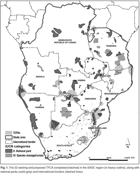
The importance of TFCA development, and the use of this concept to maintain connectivity between parks in southern Africa, is strongly supported by all 12 members of SADC. This is reflected in a recent study by Hall-Martin and Modise,15 who, in consultation with the respective governing bodies, identified 22 regions where parks can be linked together across international borders (Fig. 1). Some of these already exist as TFCAs (e.g. the Great Limpopo and Kgalagadi Transfrontier Parks), while others have the potential to become TFCAs. The Peace Parks Foundation (PPF), established in Stellenbosch in 1997, is one of a few organizations in the region that facilitate the planning and implementation of such areas. The role and actions of the PPF, which includes the lobbying of political will, sourcing and management of donor funds, as well as project planning and implementation, place them in a unique position regarding conservation in Africa. It works both at a local scale on individual TFCA projects, as well as at the sub-continental scale on general TFCA initiatives in southern Africa.
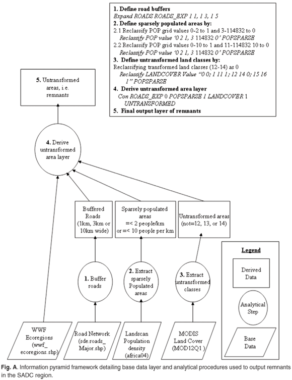
In addition to satisfying political considerations, the PPF recently developed the need to incorporate information on landscape fragmentation and threats into the general planning of TFCA initiatives. We address the first of these needs in this paper by identifying remaining tracks of large, natural habitat (hereafter referred to as remnants) in the SADC region (our study area) and clearly setting out our analytical procedures in the form of an information pyramid.25 The information pyramid concept25 provides a transparent and systematic work method, which is easy to update. This makes it an ideal tool for the PPF, where the implementation of international conservation projects often encompasses lengthy processes to achieve buy-in and political goodwill. Consequently, it is essential that the PPF uses a methodological framework that is dynamic, so that the outcomes can easily be updated in the future as, for example, the base data sets are updated, or stakeholders and their needs change. Using the information pyramid concept as a framework makes this possible because each data set and analytical step is listed explicitly, and updating the framework becomes a matter of substituting one data set for another, or altering a processing step, and re-running the information pyramid model. Such transparency in data processing is essential for facilitating communication and decision-making between planners and stakeholders from different countries, with different cultural backgrounds, needs, and goals. In addition, an information pyramid facilitates running scenarios where definitions can be changed and tested, providing an analysis of how sensitive the definition of remnants is to changes in definitions and variable values.
Natural remnants have previously been identified at a local scale (1:250 000) in the Western Cape province of South Africa by mapping transformed areas, which are then deleted from a vegetation map to leave 'natural habitat'.26 These local studies identified transformed areas as urban areas, agricultural fields, and areas with a high density of invasive alien plants.26 Consistent data on the density of invasive alien plants are not currently available at a national scale in South Africa, and so a recent study of transformed areas at a national scale for the country used certain classes of land cover (namely, cultivated, forest plantations, mines, quarries, built-up areas) and roads27 to map transformed areas. At the sub-continental scale of SADC, we were able to obtain data for land cover (urban areas, croplands, and cropland/natural vegetation mosaic) and roads, and used these following the rationale of the South African study.27 We considered that the addition of diurnal population count would supplement the identification of urban and densely populated areas. Various scenarios are run to test the impact of the values used to define the variables of road width and densely populated areas (in terms of number of people per square kilometre) on the identification of remnants. The creation of this information pyramid framework, together with its initial results, is a first step in the development of a broader systematic conservation plan4 for transfrontier conservation at a sub-continental scale.
Study area
The study area encompassed the 12 continental states of the SADC region (Angola, Botswana, Democratic Republic of Congo (DRC), Lesotho, Malawi, Mozambique, Namibia, South Africa, Swaziland, Tanzania, Zambia and Zimbabwe) (Fig. 1). Together these countries cover over 9 252 318 km2, or 31.5% of the African continent, with a total population approaching 195 million.15 The study area covers 62 of WWF's ecoregions.28 The boundaries of ecoregions and those of political entities seldom coincide, and different conservation management policies, strategies, and programmes frequently are in place for a single ecoregion stretching across two countries. The TFCA philosophy is aimed at providing stronger agreement among management policies that are applied to a particular ecoregion, or habitat, that stretches across national boundaries.
Data sets
Three medium-resolution data sets (ranging from 1:1 000 000 to 1:5 000 000) were chosen to constitute the base of our information pyramid (Table 1, Fig. A in supplementary material online). These data sets were available for the entire study region. Many areas in the region are poorly mapped, so that fine-scale data sets are not consistently available everywhere. As a result, coarse-scale data sets, which provide consistent coverage of landscape features across the study area, are valuable in international conservation planning exercises. It is also important that these layers were available at no cost, and had clearly defined metadata documents, which allowed their scientific integrity to be ascertained.
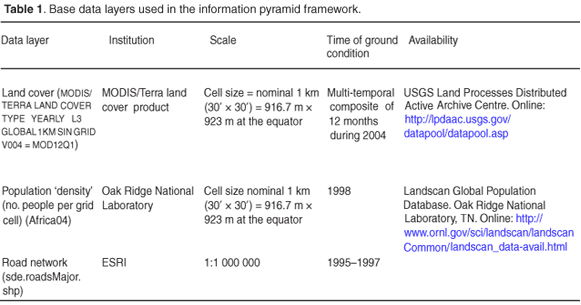
Where data were obtained in vector, or different raster, formats they were converted to ArcGIS (ESRI, Redlands, California) GRIDs with grid cell size of 30" × 30" (seconds), which equates to 916.7 m × 923 m at the equator in Africa, using nearest-neighbour resampling, and clipped to the SADC study area, with geographic bounding coordinates: West 10.701170, East 43.436183, North 5.411187 and South –34.839828. This grid cell size was used as both the population and land-cover data sets are produced at this resolution, and we considered that generalizing these data up to a slightly larger (albeit 'neater') cell size of 1000 m × 1000 m would lead to unnecessary loss of accuracy.
All data sets were (re)projected to the Lamberts Azimuthal Equal Area projection (datum: WGS84, central meridian: 20°E, latitude of origin: 5°N, units: metres).
Population density
The Landscan population database was compiled for the first time in 1998 as part of the Oak Ridge National Laboratory (ORNL) Global Population Project,29 and has since been updated a few times. We use Landscan2004. The database provides a worldwide estimate of the number of people per grid cell, that is, population density. Grid cells measure 30" × 30". The population data sets of UNEP and the Centre for International Earth Science Information Network (CIESIN) are also freely available, but at a 2.5-degree scale. Using the latter sources would result in a loss of accuracy as they are much coarser than the Landscan data set.
Land cover
Of the land cover products available from various institutions, we chose MODIS, developed for NASA's Earth Observation System programme. This product has been derived from a composite of 2004 Terra/MODIS satellite images, using an algorithm that draws from various information domains (e.g. surface reflectance in seven spectral bands, the Enhanced Vegetation Index (EVI), land-surface temperature and snow/ice cover), and has been standardized so that the product can be updated regularly.30 It is distributed at a scale of 30" × 30" grid cells. It classifies land cover according to the 17-class International Geosphere–Biosphere Project (IGBP) legend.31,32 This legend defines 11 classes of natural vegetation, three classes of naturally non-vegetated lands (snow/ice, bare soil/rocks, and water), two classes of developed lands (urban and built-up, and croplands), and one class of mosaic lands (vegetation and croplands). We considered the land classes 'croplands' (no. 12), urban and built-up (no. 13), and cropland/natural vegetation mosaic (no. 14) to represent transformed habitat. The majority of land class 'barren or sparsely vegetated' (no. 16) represents the Namib Desert and Makgadigkadi pans (when dry), and so this category is considered to represent naturally sparsely vegetated land and is not included in the definition of transformed habitat.
Roads
The impact of roads on biodiversity can be due to the direct loss of habitat, collisions with wildlife, interruption of ecosystem processes, and facilitation of wildlife utilization.33,34 Rouget and co-workers27 assumed that different road types (for instance, hard surface versus sand track) have a differential impact on biodiversity, and consequently, defined the perpendicular distance of the influence of a road on the surrounding biodiversity on a differential scale depending on road type. However, the relationship between road type and the perpendicular distance of its effect on surrounding biodiversity might not be that straightforward. Most roads in Mozambique are classified as undifferentiated, and are not expected to interrupt ecosystem processes such as animal movements (D. Kirkwood, pers. comm.), or to increase exploitation of biodiversity in these areas, due to the road's poor quality. However, this same road type in the Congo is said to increase the trade in bush meat significantly.34 It is likely that the impact of roads on habitat fragmentation and use of biodiversity is not a simple function of road type that is consistent across the SADC region. Rather, a detailed study of the relationship of road type, habitat and effects of biodiversity of roads in local areas, as well as the use of biodiversity by various communities throughout the SADC region, is required to determine the variable road impact distance. Such a study does not fall within the scope of this paper. Consequently, we used major roads data for SADC, which includes high speed, hard surface, gravel, track or trail, undifferentiated and unsurfaced road types. We examined the effect of varying the width used to define road buffers on the identification of remnants. Researchers applied a total road-effect zone of 2 km for national roads in a previous study.35 We defined road buffers having a total width of 1 km (minimum grid cell size), 3 km and 10 km. We acknowledge that even our 10 km buffer may not be wide enough to account for all effects on biodiversity observed along certain roads where the establishment of human settlements, bush-meat hunting and other exploitation of natural resources occurs.34
Building and implementing the information pyramid framework
Overton and co-workers25 addressed the necessity for systematic and transparent work methods in conservation projects, by proposing a conceptual methodological framework, the 'information pyramid'. They used the term 'pyramid' as a metaphor, to depict the hierarchical nature of analytical procedures whereby base data sets at the bottom of the pyramid are processed by means of integration, generalization and analysis, to produce the resultant information product(s) as output(s) at the apex of the pyramid (see Fig. A online). It is, in essence, a framework for explicitly depicting methods and information used to achieve specific goals, in a manner that is transparent and easy for a third party to understand and repeat. Lehmann, Overton and Leathwick36 listed criteria with such information pyramid frameworks should comply, namely that they should be (i) rigorous and data-defined in order to ensure objectivity, and also be (ii) standardized to produce uniform results. Others have also advocated that conservation planning frameworks should be based on standardized methods in order to allow for repeated measurement so that trends can be determined and results of experience incorporated.23,37–39 Few conservation plans produced in southern Africa have specifically presented their methods as an information pyramid framework, however, which makes it difficult for third parties, which are usually cash-strapped conservation-implementing organizations with limited personnel, to inherit and update.
Our information pyramid framework is presented as a highly detailed methodological flow diagram. It was designed to output maps of remnants, that depict the spatial extent of the remaining contiguous blocks of natural, untransformed habitat (terrestrial and aquatic) in the SADC region, and to act as an indication of the current state of coarse-scale habitat fragmentation. The term 'remnant' was adopted from the regional conservation planning studies of Cowling and co-workers.40 We derived remnants by erasing transformed areas from the study area. Transformed areas were defined as (i) densely populated areas, using two different definitions of population density (namely, more than two people, or more than ten people, per grid cell), (ii) areas transformed by the presence of roads, including three different buffer distances to account for some road impacts (see discussion in section above on roads data), namely, total buffer widths of 1 km, 3 km and 10 km, and (iii) urban areas (class 13) and agricultural fields (classes 12: croplands and 14: cropland/natural vegetation mosaic) as defined by the MODIS land cover data set.
It is important that our decisions as to which variable to use (e.g. densely populated areas or roads), and in particular what values are applied to define these variables (e.g. densely populated areas defined as more than two people per grid cell) are debated and tested. The information pyramid provides a framework for the generation of results using different variables and values to identify remnants in the SADC region, so that we can ascertain how sensitive the results are to variations in the choices made.This information pyramid framework, with its data and methods, was implemented in ArcGIS 9.2.
Results and discussion
Sensitivity analysis of results to criteria and definitions
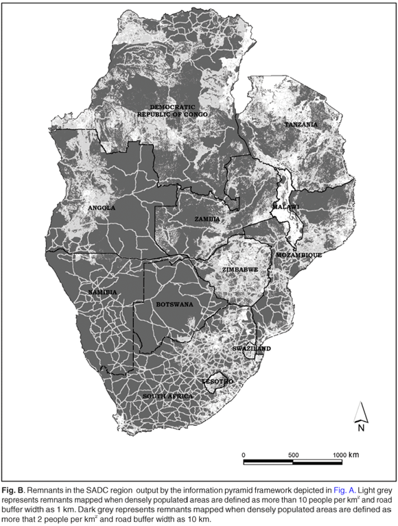
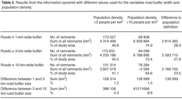
The information pyramid that we used is illustrated in Fig. A. Depending on the values used to define the variables of road width and population density, the areas of remnants generated by our information pyramid vary from 3 807 079 km2 (41.1% of SADC region; dark grey in Fig. B online) to 6 928 894 km2 (74.9%; light grey in Fig. B). A change in the definition of the roads buffer width results in a relatively small change in the spatial configuration, and total area of remnants, identified. When the width of the road buffer is increased from 1 km to 3 km, the area of remnants identified drops from 4 314 499 km2 to 4 205 186 km2, i.e. a reduction of 1.18% of the area mapped as remnants (when densely populated areas are defined as more than two people per square kilometre). When the width of the road buffer is increased still further, from 3 km to 10 km, the area of remnants identified drops even more to 3 807 079 km2 (a further decline of 4.3%). Consequently, the area of SADC identified as remnants changes from 46.6% when the road width is defined as 1 km to 41.1% when the road width is increased to a 10-km buffer (with densely populated areas defined as more than two people per square kilometre). The road buffer width therefore does not have large implications for the results generated by this information pyramid, at a scale of 1:1 000 000, and we aver that it is not a pivotal factor in the identification of remnants at a broad scale.
In contrast, if the definition of densely populated areas is changed from more than ten people per square kilometre to more than two (for a road buffer width of 1 km), the area identified as remnants changes from 6 928 894 to 4 314 499 km2, a decrease of 28.3%. This change in the area under the two definitions of densely populated areas is constant across all definitions of road buffer width (see Table 2). Thus, it seems that accurate population data and the selection of the 'correct' number of people per square kilometre to define densely populated areas is a more important factor than road buffer width, due to the former's greater effect on the results.
This comparison of results illustrates the usefulness of the information pyramid concept, where methods are clearly laid out, allowing for rapid rerunning of analyses with altered parameters, in order to test the sensitivity of the results to the selection and definition of parameters.
Location of remnants relative to biodiversity and conservation challenges
The spatial arrangement of remnants is largely constant, regardless of the values used to define the road width buffer and less populated area, even though the total area of remnants identified drops by between 23.5% and 28.3% as the definition of population density is varied (see Fig. B in supplementary material online). Most remnants are concentrated in the southwestern regions of Africa, specifically in Namibia, Botswana and the western regions of South Africa, western and central Zambia, and eastern parts of Angola. As population density definitions are made stricter, remnants are no longer identified in most of Zimbabwe and Tanzania; in portions of Zambia and central Mozambique; in the western part of Angola from the Cuanza Sul escarpment to the Bie Plateau; and the western DRC around Kinshasa and eastwards along the transcontinental road to the Kasai and Kivu districts (adjacent to Rwanda and Burundi). Notice that the southeastern portion of the DRC, namely the Katanga region, still consists largely of remnants.
These patterns coincide strongly with current population density trends, as can be expected from the methods used. In addition, there is overlap with specific vegetation, soil and topographical features, which presumably relate to agricultural potential of an area and its potential to sustain resident populations. For example, the 'disappearance' of remnants on and to the north of the Bie Plateau, corresponds with an intrusion of the Kalahari sands into the Congo forest.41,42 'Disappearance' of remnants between Kinshasa and Kivu largely corresponds with the complex transition between forest and savanna that occurs within the Congo basin on slightly higher ground. Loss of remnants in northern South Africa corresponds with highly productive grasslands, as well as proximity to major commercial and industrial centres.
The remnants ranged from being just larger than 0.69 km2 to 82 158 km2 in size, with the largest located in the Kalahari xeric savanna ecoregion.28 Many of the remnants identified are in drier savanna and desert areas as these areas support lower human population densities and agricultural activities than the more mesic.43–45 However, such xeric areas are also more susceptible to degradation at low population densities (J. Fjeldså, pers. comm.) and so care must be taken not to interpret these remnants with low human population densities in arid savannas as robust, wilderness areas providing 'safe' refuges for wild-life.43–45
The distribution, shape and size of remnants is potentially an important knowledge-base for planners at the PPF, who can use it to identify natural landscape linkages between two TFCAs. Parks on the African continent have been shown to be too distant from each other to allow exchange of individuals of even the most mobile taxa,8 and thus the need to identify and protect intact habitat between parks becomes even more critical in the SADC region. Adequate accessibility between parks through natural areas is important for (i) the maintenance of the large-scale movements of animals as they track resource availability, which are characteristic of African savannas (for example, the passage of wildebeest, zebra, buffalo, and other species, between Serengeti and Ngorongoro), (ii) genetic exchange, and (iii) maintenance of species requiring large areas which, even in large parks, can be supported in only small numbers. Contiguous remnants may be crucial for maintaining space demanding megafauna, and may facilitate agreement about transboundary conservation initiatives due to lower levels of conflict with current land use. Many studies indicate that biodiversity hotspots, however, as well as centres of diversification, are often in areas which are also densely populated, evidently because conditions favouring long-term accumulation of species will also be favourable for people.43–45 This is why we need living landscapes – for managing land use outside parks in areas were land-use pressures can be high in biodiversity hotspots. This can be done by encouraging eco-friendly land uses and habitat restoration (such as the Working for Water initiative, see www.dwaf.gov.za/wfw/, and the Working for Wetlands initiative, see www.sanbi.org/research/wetlandprog.htm and www. dwaf.gov.za/wfw/Wetlands/) in highly fragmented landscapes, sustaining them as open (or less developed) spaces so as to curtail biodiversity loss or help sustain ecological processes. The Working for Water programme aims to clear invasive alien species that threaten South Africa's biodiversity and water security.47,48 Some cleared areas are targeted for rehabilitation to natural, pre-infestation floral diversity, in order to provide ecological robustness and increased resistance to repeat invasions. Working for Wetlands aims to restore ecological functioning of wetlands and so improve water security in South Africa.
Role of information pyramids in PPF decision-making
Various authors have emphasized the need to apply efficient, rigorous methods that are transparent and repeatable in all arenas of conservation decision-making.4,25,40 This is particularly relevant in transfrontier conservation projects, where stakeholders may represent different countries, and where political considerations play a central role in decision-making. This situation makes it imperative to use methodological frameworks that can be clearly communicated and that are easy to update regularly. This is achieved in our framework, which has a foundation made up entirely by raw, standardized, data products, which are processed upwards through a series of clearly stated analytical steps to derive specific end results. The fact that all inputs and processing steps are listed explicitly makes this methodology transparent and easy for a third party to evaluate in terms of its objectivity, or for them to inherit and implement. In addition, once such an information pyramid framework has been designed to address specific conservation questions, updating the outcomes (after the release of better base data, or as the understanding of ecological processes and social influences improves), becomes a matter of simply replacing a base data layer, or modifying parameters used in the analysis. In this way, one can obtain updated and improved products with an analytical rotation cycle that is much shorter than is possible when a method is not clearly represented in a framework.46 It also allows for the framework and its outputs to remain dynamic and current as situations on the ground change.
A sense of the rate at which transformation (such as urbanization and agricultural expansion) threatens remnants could be achieved by performing change analysis on a time series of remnant layers. Such a time-series analysis, indicating the increase or decrease in remnant size or number (through habitat transformation) over time, could also act as performance indicators for the PPF in areas where they have implemented conservation projects.
With these potential applications in mind, decisions as to which data sets should constitute the base of the pyramid framework are important, as the final products need to be spatially and temporally accurate in order to ensure that the outputs are relevant. For example, in this framework the land cover data influence the deletion of remnants in the northeastern interior and east coast of South Africa, patches in Zimbabwe, in southern Malawi, along the east coast of Tanzania and around the shores of Lake Victoria. The MODIS land cover product is assembled for a year of observations for each nominal 1-km pixel using a decision-tree classifier that has been ground truthed from a network of more than 1500 training sites.30 The MODIS product can consequently be used with a high level of confidence, although it should be borne in mind that all land cover products underestimate habitat degradation when utilization (such as overgrazing) leads to a change in species composition and community structure without influencing the plant cover.
Conclusions
The information pyramid framework presented in this paper, together with the remnants layers as the framework's outcomes, should not be seen as a vehicle by which to achieve a final solution to the identification of corridors between parks to form TFCAs. Rather, it aims to provide an initial identification of remaining large natural areas that could become part of the multiple-use resource areas that link parks to form TFCAs, and thereby create functional landscapes. This initial result needs to be further developed by explicitly mapping coarse-scale ecological processes, and using climatic data to identify critical areas for speciation. These results will contribute to a larger decision-making process which integrates biological surveys, statistical modelling, policy developments, legislation, and political tactics with GIS analyses,37–39 which will form a larger conservation plan for PPF action in the SADC region. In such an integrated process, the framework could help to build political consensus and public support in an open and accountable manner, and assist in defining and building support for broad directions regarding conservation goals. In other words, the spatial framework could serve as an information backdrop in decision-making that enhances—not replaces—the expertise and judgment of managers.39
PPF planners, resource managers and decision-makers in the conservation arena are constantly faced with the task of providing answers to a host of problems that are related to improving the well-being of ecological systems, as well as human communities. The conservation of natural ecosystems has become an important consideration in addressing issues of community upliftment and economic growth, in conjunction with biodiversity protection. This study found that the use of GIS technology within an information pyramid framework has the potential to play an integral part in the performance of these tasks in monitoring the outcome of such actions.
We thank the Peace Parks Foundation and CapeNature for funding. In addition, we would like to thank Jon Fjeldså, Donovan Kirkwood, and three anonymous reviewers for comments on an earlier draft.
1. De Villiers B. (1999). Peace Parks—The way ahead: International experience and indictors of Southern Africa. HSRC Publishers, Pretoria. [ Links ]
2. Zbicz D.C. (2001). Global list of internationally adjoining protected areas. In Transboundary Protected Areas for Peace and Co-operation, eds T.S. Sandwith, C. Shine, L.S. Hamilton and D.A. Sheppard, pp. 55–75. IUCN, Gland, Switzerland and Cambridge, U.K. [ Links ]
3. Rebelo A.G. (1997). Conservation. In Vegetation of Southern Africa, eds R.M. Cowling, D.M. Richardson and S.M Pierce, pp. 571–590. Cambridge University Press, Cambridge. [ Links ]
4. Margules C.R. and Pressey R.L. (2000). Systematic conservation planning. Nature 405, 243–253. [ Links ]
5. Reyers B. (2003). Evaluating Transboundary Protected Areas: Achieving biodiversity targets. Proc. 5th World Parks Congress, Durban, South Africa, 12–13 September 2003. Online: www.tbpa.net/docs/WPCGovernance/Belinda Reyers.doc [ Links ]
6. Lombard A.T., Nicholls A.O. and August P.V. (1994). Where should nature reserves be located in South Africa? A snake's perspective. Cons. Biol. 9, 363–372. [ Links ]
7. Pressey R.L. (1994). Ad hoc reservations: forward or backward steps in developing representative reserve systems? Cons. Biol. 8, 662–668. [ Links ]
8. Siegfried W.R., Benn G.A. and Gelderblom C.M. (1998). Regional assessment and conservation implications of landscape characteristics of African National Parks. Biol. Cons. 84, 131–140. [ Links ]
9. Walker B.H. (1994). Landscape to regional-scale responses of terrestrial ecosystems to global change. Ambio 23, 67–73. [ Links ]
10. Pabst M. (2001). Transfrontier Peace Parks in Southern Africa. Southern Africa Initiative of German Business, Stuttgart. [ Links ]
11. van der Linde H.J., Oglethorpe J., Sandwith T., Snelson D. and Tessema Y. (with contributions from Anada Tiéga and Thomas Price) (2001). Beyond Boundaries: Transboundary Natural Resource Management in Sub-Saharan Africa. Biodiversity Support Program, Washington, D.C. [ Links ]
12. Sandwith T., Shine C., Hamilton L. and Sheppard D. (2001). Transboundary Protected Areas for Peace and Co-operation. IUCN, Gland, Switzerland, and Cambridge, UK. [ Links ]
13. Hanks J. (2003). Transfrontier Conservation Areas (TFCAs) in southern Africa: their role in conserving biodiversity, socioeconomic development and promoting a culture of peace. J. Sustain. For. 17, 121–142. [ Links ]
14. SADC (1999). Protocol on Wildlife Conservation and Law Enforcement. Online: www.iucnrosa.org.zw/elisa/SADC-Protocols/wildlife_protocol.html [ Links ]
15. Hall-Martin A. and Modise S. (2002). Existing and potential transfrontier conservation areas in the SADC region. Status report. Peace Parks Foundation, Stellenbosch. [ Links ]
16. Driver A., Cowling R.M. and Maze K. (2003). Planning for Living Landscapes: perspectives and Lessons from South Africa. Center for Applied Biodiversity Science and Conservation International, Washington D.C., and Botanical Society of South Africa, Cape Town. [ Links ]
17. Schonewald-Cox C.M. and Bayless J.W. (1986). The boundary model: a geographic analysis of design and conservation of nature reserves. Biol. Cons. 38, 305–322. [ Links ]
18. Saunders D.A., Hobbs R.J. and Margules C.R. (1991). Biological consequences of ecosystem fragmentation: a review. Cons. Biol. 5, 18–32. [ Links ]
19. Mwalyosi R.B.B. (1991). Ecological evaluation for wildlife corridors and buffer zones for Lake Manyara National Park, Tanzania and its immediate environment. Biol. Cons. 57, 171–186. [ Links ]
20. Taylor P.D., Fahrig L., Heinen K. and Merriam G. (1993). Connectivity is a vital element of landscape structure. Oikos 68, 571–573. [ Links ]
21. Hobbs R.J. (1992). The role of corridors in conservation: solution or bandwagon? TREE 7, 389–392. [ Links ]
22. Walker R. and Craighead L. (1997). Analyzing wildlife movement corridors in Montana using GIS. Proc. 1997 ESRI International User Conference. Online: gis.esri.com/library/userconf/proc97/proc97/to150/pap116/p116.htm [ Links ]
23. Noss R.F. (2003). A checklist for wildlands network designs. Cons. Biol. 17, 1270–1275. [ Links ]
24. Kubes J. (1996). Biocentres and biocorridors in a cultural landscape. A critical assessment of the territorial system of ecological stability. Landscape and Urban Planning 35, 231–240. [ Links ]
25. Overton J. McC., Stephens R.T.T., Leathwick J.R. and Lehmann A. (2002). Information pyramids for informed biodiversity conservation. Cons. Biol. 11, 2093–2116. [ Links ]
26. Rouget M., Richardson R.M., Cowling R.M., Lloyd J.W. and Lombard A.T. (2004). Current patterns of habitat transformation and future threats to biodiversity in terrestrial ecosystems of the Cape Floristic Region, South Africa. Biol. Cons. 112, 63–85. [ Links ]
27. Rouget M., Reyers B., Jonas Z., Desmet P. et al. (2005). South African National Spatial Biodiversity Assessment 2004: Technical Report. Vol. 1: Terrestrial Component. South African National Biodiversity Institute, Pretoria [ Links ]
28. Olson D.M., Dinerstein E., Wikramanayake E.D., Burgess N.D. et al. (2001). Terrestrial ecoregions of the world: a new map of life on earth. BioScience 51, 933–938. [ Links ]
29. Bhaduri B., Bright E., Cleman P. and Dobson J. (2002). LandScan: Locating People is What Matters. Geoinformatics Vol. 5, No. 2, pp. 34–37. (Landscan Global Population Database, Oak Ridge National Laboratory. Online: www.ornl.gov/ sci/landscan/landscan2004/landscan04_readme.html) [ Links ]
30. Parkinson C.L. and Greenstone R. (2000). MTPE-EOS Data Products Handbook. Online: eospso.gsfc.nasa.gov [ Links ]
31. Belward A.S. (ed.) (1996). The IGBP-DIS global 1 km land cover data set 'DISCover' – Proposal and implementation plans. IGBP-DIS Working Paper, No. 13. Land Cover Working Group of the IGBP-DIS, Stockholm. [ Links ]
32. Loveland T.R., Zhu Z., Ohlen D.O., Brown J.F., Reed B.C. and Yang L. (1999). An analysis of the IGBP global land-cover characterization process. Photogrammetric Engineering and Remote Sensing 65, 1021–1032. [ Links ]
33. Trombulak S.C. and Frissell C.A. (2000). Review of ecological effects of roads on terrestrial and aquatic communities. Cons. Biol. 14, 18–30. [ Links ]
34. Wilkie D., Shaw E., Rotberg F., Morelli G. and Auzel P. (2000). Roads, development, and conservation in the Congo Basin. Cons. Biol. 14, 1614–1622. [ Links ]
35. Reyers B., Fairbanks D.H.K., van Jaarsveld A.S. and Thompson M. (2001). Priority areas for the conservation of South African vegetation: a course–filter approach. Diversity and Distribution 7, 79–95. [ Links ]
36. Lehmann A., Overton J.McC. and Leathwick J.R. (2003). GRASP: generalized regression analysis and spatial prediction. Ecological Modelling 160, 165–183. [ Links ]
37. Rookwood P. (1995). Landscape planning for biodiversity. Landscape and Urban Planning 31, 379–385. [ Links ]
38. Bell S. and Morse S. (2000). Sustainability Indicators: Measuring the Immeasurable. Earthscan Publications, London. [ Links ]
39. Pressey R.L. and Cowling R.M. (2001). Reserve selection algorithms and the real world. Cons. Biol. 15, 275–277. [ Links ]
40. Cowling R.M., Pressey R.L., Rouget M. and Lombard A.T. (2003). A conservation plan for a global biodiversity hotspot—the Cape Floristic Region, South Africa. Biol. Cons. 112,191–216. [ Links ]
41. Van Zinderen Bakker E.M. (1976). The evolution of late-Quatenary palaeoclimates of southern Africa. Palaeoecol. Afr. 9,160–202. [ Links ]
42. Hamilton A.C. (1982). In Environmental History of East Africa: A Case Study of the Quaternary, pp. 224–232. Academic Press, London. [ Links ]
43. Fjeldså J. and Lovett J.C. (1997). Geographical patterns of old and young species in African forest biota: the significance of specific montane areas as evolutionary centres. Biodiversity and Conservation 6, 325–346. [ Links ]
44. Balmford A., Moore J.L., Brooks T., Burgess N., Hansen L.A., Williams P. and Rahbek C. (2001). Conservation conflicts across Africa. Science 291, 2616–2619. [ Links ]
45. Burgess N., Kuper W., Mutke J., Brown J., Westaway S. et al. (2005) Major gaps in the distribution of protected areas for threatened and narrow range Afrotropical plants. Biodiversity and Conservation 14, 1877–1894 [ Links ]
46. Tapiador F.J. and Casanova J.L. (2003). Land use mapping methodology using remote sensing for the regional planning directives in Segovia, Spain. Landscape and Urban Planning 62, 103–115. [ Links ]
47. Marais C., van Wilgen B.W. and Stevens D. (2004). The clearing of invasive alien plants in South Africa: a preliminary assessment of costs and progress. S. Afr. J. Sci. 100, 97–103. [ Links ]
48. Zimmermann H.G., Moran V.C. and Hoffmann J.H. (2004). Biological control in the management of invasive alien plants in South Africa, and the role of the Working for Water programme. S. Afr. J. Sci. 100, 34–40. [ Links ]
Received 14 June.2005. Accepted 15 October 2007.
This article is accompanied by supplementary information online at www.sajs.co.za
* Author for correspondence. E-mail: hdeklerk@capenature.co.za
Supplementary material to:
Smith N. and de Klerk H. (2007). Geo-information pyramids for up-to-date and flexible conservation plans: a case study for Transfrontier Conservation Areas. S. Afr. J. Sci. 103, 442–448.