


Serviços Personalizados
Artigo
 Inglês (pdf)
 Artigo em XML
 Referências do artigo
Indicadores

Links relacionados
-
 Citado por Google
 -
 Similares em Google
Compartilhar

 Permalink
South African Journal of Science
versão On-line ISSN 1996-7489
versão impressa ISSN 0038-2353
S. Afr. j. sci. vol.103 no.7-8 Pretoria Jul./Ago. 2007
SAEON REVIEWS
Monitoring soil erosion in South Africa at a regional scale: review and recommendations
J.J. Le RouxI, *; T.S. NewbyII; P.D. SumnerI
IDepartment of Geography, Geoinformatics and Meteorology, University of Pretoria, Pretoria 0002, South Africa
IIInstitute for Soil, Climate and Water, Agricultural Research Council, Private Bag X79, Pretoria 0001
ABSTRACT
Loss of topsoil is one of the principal soil degradation problems confronting agriculture throughout South Africa and receives special attention by policy-makers. For effective prevention and remediation, the spatial extent of the problem has to be established and monitored. Recent developments in the application of remote sensing and GIS to the study of soil erosion offer considerable potential in this regard. This paper outlines key technologies available for monitoring, and highlights the problems to be solved at a regional scale. The status of the technologies used in South Africa are reviewed and the more recent studies related to soil erosion are presented in a comparative context. Spatial, temporal and measurement variabilities are major constraints in erosion assessment. Previous erosion studies conducted in South Africa at the regional scale have disregarded important erosion factors and have overvalued less important ones. Different processes and interactions are likely to emerge as dominant when crossing scale boundaries. Such considerations highlight the need to establish a methodological framework to guide and standardize future regional soil loss monitoring efforts.
Introduction
Soil erosion is a major problem confronting land resources throughout South Africa. Previous research indicates that over 70% of the country's surface has been affected by varying intensities and types of soil erosion.1,2 Although erosion is a natural process, it is accelerated by human activities such as clearing vegetation or overgrazing.3 Land degradation caused by soil erosion not only involves the loss of fertile topsoil and reduction of soil productivity, but also leads to sedimentation of reservoirs and increases suspended sediment concentrations in streams, with consequent effects on ecosystem health.4
Erosion is a process of detachment and transportation of soil materials by wind or water.5 Since water is the dominant agent causing erosion in South Africa,6 it is the focus of this review. Water erosion can occur through rainsplash, in unconcentrated flow as sheet erosion, or in concentrated flow as rill and/or gully erosion.7 Outcomes depend on the combined and interactive effects of erosion factors, namely, rainfall erosivity, soil erodibility, slope steepness and slope length, crop management, and support practice.8 Assessment of erosion thus requires knowledge of how these factors change across different scales of space and time. More detail on the factors governing erosion, specifically in a South African context, is provided by Laker,6 Mulibana,9 D'Huyvetter10 and Garland et al. 2
Remediation and prevention require that the spatial extent of erosion be established. Many observations of soil erosion have been carried out in South Africa,11,12 but the derived statistical relationships from individual erosion measurements are confined to local conditions and do not provide a sufficiently broad range of input data for regional soil loss monitoring.15 Although erosion control measures need to be implemented at the field or hillslope scale, allocation of scarce conservation resources and development of policies demands regional scale assessment.15 Geographic Information Systems (GIS) and remote-sensing techniques, as well as soil erosion models applied within a spatial context, play an important role at the regional scale. We review available technologies with international standing for this purpose, and the techniques and approaches used in South Africa. More recent techniques and products related to soil erosion at a national scale receive special attention. These accounts are followed by a discussion of the main assessment-related deficits, and recommendations for future research.
Technologies available for monitoring
A wide variety of techniques are available for assessing soil erosion risk across a wide range of scales.5,15–22 Slope-scale measurements include field rainfall simulation studies and the use of delineated runoff plots,12,13,23–25 which provide valuable data on erosion rates of different crop covers and soil types. Although essential for calibration and verification of soil loss models, such field experiments apply only to one or a few hillslopes and cannot be directly extrapolated to evaluate and monitor erosion for a whole catchment.26 Methods designed to analyse and interpret broader spatial scales are thus becoming increasingly important.27 The advent of recent developments in the application of GIS and remote-sensing technology offer considerable potential for meeting these requirements.
Remote sensing
Remote-sensing techniques using aerial photographs and satellite remote-sensing data have greatly increased the capacity to record and monitor land degradation at the regional level.28 Important sensor development has taken place through airborne systems, including photogrammetric methods, using stereo images,4,29 synthetic aperture radar interferometry,30 airborne laser altimetry31 and hyperspectral remote sensing.15 Although airborne systems and methods are useful in the direct identification of erosion, they are not feasible for monitoring erosion at a national scale, for which satellite imagery is better adapted.
Five types of satellite-based observations can be undertaken.15,22 First, large eroded surfaces can be visually interpreted, based on deviating spectral properties.28 Second, modifications of the former technique involve automatic extraction, including unsupervised and supervised classification, using principal component analysis and the maximum likelihood technique, amongst others.32,33 Highest accuracy can be achieved using a combination of images from different sensors, e.g. Landsat Thematic Mapper (TM) and Japanese Earth Resources Satellite synthetic aperture radar (SAR) data.34
Third, direct correlation between erosion and spectral reflectance values sometimes permits the detection of erosion and its intensity. An empirical relation between erosion and reflection can be used, assuming a relation between vegetation cover and erosion.35 The fourth category includes visual interpretation and detection of off-site impacts, such as sediment deposition36 as well as dissolved sediment.37 The fifth application uses repeat pass SAR interferometry that allows assessment of the change in erosion.38
Until recently, detection of erosion features with satellite data was difficult due to inadequate resolution.39 Usually, higher-resolution data (e.g. Système pour l'Observation de la Terre, SPOT) are better for classifying eroded areas, whereas a larger number of spectral bands (e.g. Landsat TM) allows for a better classification of vegetational attributes.40 Space-borne data with improved spectral, spatial and temporal resolution are now available with advances in sensor technology. Although not yet reported in the literature, new high-resolution satellite imagery such as from SPOT 5, IKONOS and Quickbird are very promising for identifying erosion features, such as individual gullies.41 However, automatic retrieval of individual features is not currently available due to the heterogeneity of the object itself as well as the environment.21 Most remote-sensing studies of soil erosion thus concentrate on the assessment of erosion risk factors, notably, the vegetal attributes and, to a lesser extent, soil erodibility, topography and conservation practices.15, 16
Spatial modelling/analysis
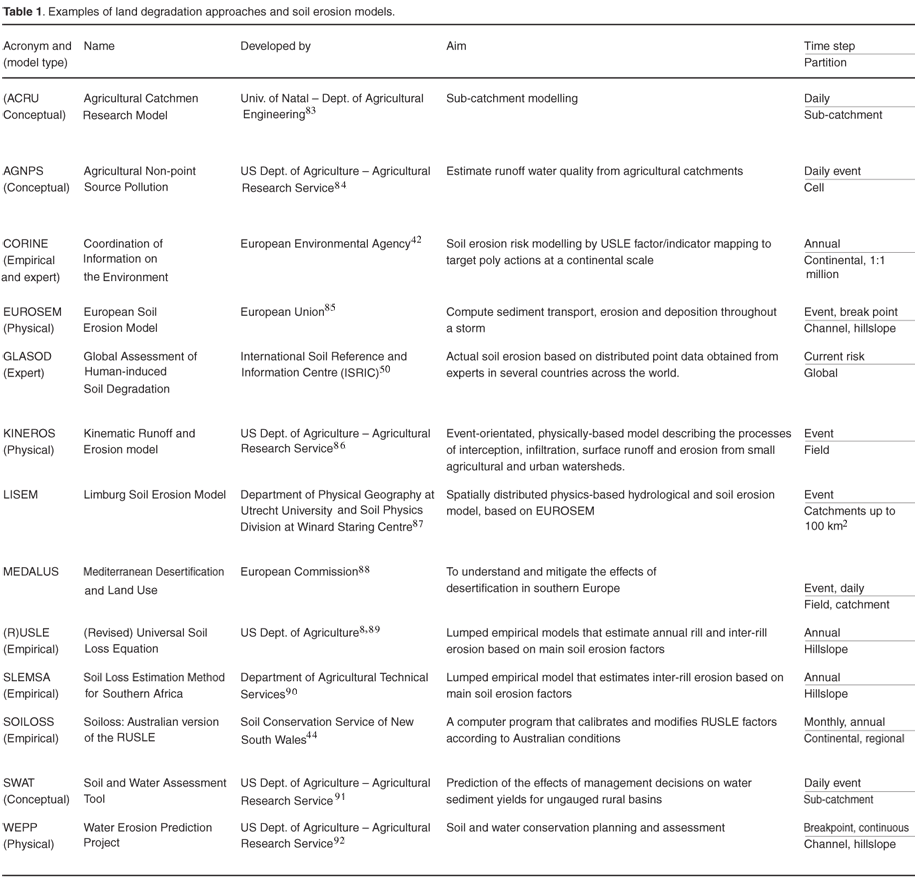
Differentiation between classes of models usually rests on the level of complexity used to represent the soil erosion processes, and on the spatial and temporal resolution of the model. Models fall into three main categories: empirical, conceptual, and physically based models.19 Table 1 summarizes selected models in terms of their classification and scale of application. The best-known and widely implemented empirical models for estimating soil loss at the regional scale are USLE, developed in the 1970s by the US Department of Agriculture (USDA), and its upgraded version RUSLE. Although devised for application to small hillslopes, (R)USLE and its derivatives have been incorporated into many regional-scale erosion studies across the globe. The European Environment Agency,42 the USDA,43 and the National Land and Water Resources Audit of Australia14,44 have presented some of the most sophisticated work, namely, CORINE, USLE, and SOILOSS, respectively. Conceptual models represent reality better, by incorporating the underlying transfer mechanisms of sediment and runoff generation in their structure, representing flow paths in a catchment as a series of storages.19 Physically based models have a much more sophisticated model structure, being based on the solution of fundamental physical equations describing streamflow and sediment on a hillslope, or in a catchment.
Other categories include continuous simulation models (e.g. SWAT, AGNPS, ACRU), event-based models (e.g. KINEROS, LISEM), lumped models (e.g. RUSLE, SLEMSA) and distributed models (e.g. KINEROS). The first simulates long time periods with a time step of 1 h–1 day; the second uses a small time step (<1 min) to simulate a single event; the third employs single values of input parameters with no spatial variability, while the last incorporates spatially distributed parameters by taking explicit account of spatial variability.
The data requirements of models dramatically increase with the introduction of spatial (distributed) and temporal (eventbased and continuous time step) complexity. For example, distributed and continuous simulation models require large quantities of spatial and temporal data for weather and land use. Several authors state that the description of water fluxes over and through the soil is the foundation of an erosion model.16,17,20
Additional information, in particular, changes in soil structure resulting from agricultural activities, greatly improves the quality of results. However, complex models tend to be restricted to research catchments and are prohibitive in terms of the time required for implementation on a regional basis as required by government policies. According to Prosser et al.,45 this is the main reason why empirical models are frequently preferred to more complex models, especially at a regional scale. They can be implemented in areas with limited data and are particularly useful as a first step in identifying sources of sediment.
Furthermore, input errors may increase with growing model complexity. This prevents the application of American models, such as WEPP and KINEROS, or EU-funded models such as EUROSEM and MEDALUS. According to Garen et al.,16 it is not expected that physically based models such as WEPP will find use in state and field offices of the Natural Resources Conservation Service (NRCS) (formerly the Soil Conservation Service). Instead, the empirical and conceptual models, namely RUSLE, SWAT and AGNPS, were adopted by the NRCS for modelling at the regional scale. A user interface, as developed for the AGNPS and SWAT models, streamlines access to key databases and facilitates the preparation of input data sets in the US. Techniques involving GIS and algorithms for digital terrain analysis are readily available and are currently improving the hydrological process description in models. Such algorithms are currently used to identify catchment boundaries, determine stream networks and establish overland flow paths, as described by Taudem,46 HydroTools47 and Tapes.48
Soil erosion modelling suffers from a range of problems including data variability, over-parameterization, unrealistic input requirements, unsuitability of model assumptions or misleading parameter values in local context and lack of verification data. Recent assessments of the quality of erosion models showed that, in general, the spatial patterns of erosion are poorly predicted.19,49 Furthermore, models can rarely be relied upon to give accurate predictions of absolute amounts of erosion. Without adequate input data and calibration, models can only be expected to give a relative ranking of the effects of land management.16 Input data preparation is a laborious task and the mechanics of operating the models is sometimes complicated.17 A large part of the effort goes into the construction of the input data set, often derived from a few basic variables that are available as raw data. Despite these limitations, soil erosion models have been modified and applied to regional scales for scenario analysis, and to make objective comparisons that are important for targeting of research and soil conservation efforts in South Africa.
Background of erosion assessment in South Africa at a national scale
The Department of Agriculture (DoA) and the Water Research Commission (WRC) have funded a number of regional-based research projects in South Africa. Starting in 1991, national studies are summarized in terms of their method and scale of application (Table 2). GLASOD was one of the first major regional-scale degradation studies conducted by recognized experts in several countries across the globe,50 including South Africa.6 Experts divided soil erosion areas into relatively uniform units based on the most important erosion processes. A relative ranking of soil erosion risk per area was obtained therefrom and a soil erosion risk map was produced at a continental scale.
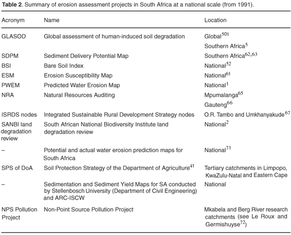
Thereafter, the use of remote sensing was investigated in 1993 in monitoring soil erosion on a national scale. The Bare Soil Index (BSI) was developed with Landsat TM data, making it possible to detect the status of eroded areas on a national scale.52 The BSI proved to be reliable in identifying rural settlements and overgrazed and eroded areas in the Mpumalanga and Eastern Cape provinces. Review of the results indicated, however, that the BSI did not differentiate ploughed fields and sandstone outcrops from eroded areas. Furthermore, due to the limited resolution of Landsat TM data (30 m), single gullies, and limited rill or sheet erosion could not be delineated.
Most regional-based studies concentrated on the assessment of erosion controlling factors, including rainfall erosivity, soil erodibility, slope length and steepness, vegetal attributes and conservation practices. These are the well-known USLE erosion factors. USLE,53–56 RUSLE55–58 and SLEMSA56,59,60 have been the most widely applied models in South Africa. Production of the Erosion Susceptibility Map (ESM) was the first attempt at national level to integrate the main erosion risk factors within a GIS framework.61 The ESM at a scale of 1:2.5 million was created by integrating spatial data on sediment yield, provided by Rooseboom et al.62 and Verster,63 with remotely sensed vegetation data, namely, a normalized difference vegetation index from the National Oceanic and Atmospheric Administration–Advanced Very High Resolution Radiometer (NOAA–AVHRR) sensor. A second attempt to integrate the main erosion contributing factors at a national level followed in 1998 with the production of the Predicted Water Erosion Map (PWEM) of South Africa.1 Improvements on ESM involved, in part, the inclusion of long-term rainfall erosivity data obtained from the iso-erodent map of Smithen and Schulze.64 Also at a scale of 1:2.5 million, PWEM indicates that a very large percentage of the Limpopo (60%) and Eastern Cape (56%) provinces are under severe threat of erosion, whereas the Gauteng and North West provinces seem to be the least threatened by water erosion. The method of ESM and PWEM, however, was based on a considerable simplification of USLE; by combining soil and slope factors with sediment yield data, obtained from Rooseboom62 and Verster.63 Research continues at a provincial scale as PWEM is only suitable for the prioritization of problem areas on a broad scale, due to the coarse resolution (1.1 km) of NOAA images.
Mapping and monitoring of natural resources of Mpumalanga65 and Gauteng66 was completed in 2001 and for the O.R. Tambo and Umkhanyakude ISRDS nodes, located in northern Eastern Cape and KwaZulu-Natal, in 2004.67 Improvements to ESM and PWEM include specific attention to the soil erodibility and topography input factors. Soil erodibility index values were utilized by using SLEMSA. In the absence of soil analytical and experimental data, two alternative sources of soil information were used, namely, soil maps (1:50 000 and 1:250 000)68 and the Land Type Inventory database (1:50 000).69 Topography factors were facilitated by the application of digital elevation models and the unit stream power theory developed by Moore and Burch.70 Results indicate that areas with high erosion potential occur mostly in subsistence farming areas associated with steep slopes and highly erodible soils. However, some units displayed by the erosion hazard maps gave the wrong impression of current soil loss damage. Erosion rates seem to be over-predicted in some of the subsistence farming areas with steep slopes, as well as in mountainous terrain with long and steep slopes.
The most recent overview on a national scale has been compiled by the South African National Biodiversity Institute.2 A national soil degradation review was compiled using information obtained from 34 workshops throughout South Africa, held during 1997 and 1998. Results were presented as a series of maps, illustrating the type and severity of soil degradation of different land use types for each magisterial district. The approach is limited by being lumped for each magisterial district, and due to its dependence on apparently subjective judgments.
ISCW is currently involved in several region-based erosion studies funded by DoA and WRC (see Table 2). These include: potential and actual water erosion maps of South Africa, currently being validated;71 remote sensing (SPOT 5) and modelling (SWAT and RUSLE) of the erosion status of three priority tertiary catchment areas, located in the Eastern Cape, KwaZulu-Natal and Limpopo provinces, identified by the Soil Protection Strategy of the DoA;41 sedimentation and sediment yield maps for South Africa to improve the sediment yield maps of Rooseboom et al.;62 and modelling of runoff and sediment transport processes at field to catchment scale to improve understanding of the requirements and processes accounted for by models with international standing, such as SWAT and KINEROS (see ref. 72). The following section discusses how the South African studies compare with the available international monitoring technologies.
Discussion
Spatial pattern prediction of soil erosion is generally not very accurate, due to spatial and temporal variability.49 Although soil erosion has been regarded as an important phenomenon in South Africa since the turn of the century, one of the weaknesses of South African soil erosion research is the limited information on where the worst problems are located.73 Errors are assumed to be high in certain areas because of the unknown input factors, especially the vegetation cover factor for various land-use practices. More research is needed to assess the confidence limits for the erosion estimates generated for South Africa at a national scale.
According to Vrieling,5 it is striking that many of these studies across the globe have minimally addressed the issue of validation. Studies merely relate the actual range of quantitative erosion rates to measured or predicted values from literature, and are satisfied when values correlate. This is probably because, other than visual comparison of maps, there are very few pattern comparison techniques.49 According to the EEA,7 proper validation obtained from applying an erosion model at a national scale is hardly possible. Widespread and long-continued soil loss measurements or observations are limited to selected test areas. In South Africa, limited plot-scale measurements of erosion (e.g. Cedara Agricultural Research Station in KwaZulu-Natal since 1983)25 allow limited regional validation and calibration of USLE factors. Empirical models still need to be appropriately adapted and validated over a long-term and wide range of conditions in South Africa.
Soil erosion encompasses a vast array of processes, which makes its assessment difficult to encapsulate in a few simple measures. Erosion occurs over a large variety of timescales, such as from a single storm to many decades. Furthermore, soil loss occurs over many spatial scales, including the site of impact from a single raindrop to large fields and catchments. Therefore, measurements undertaken at one set of scales cannot be compared with measurements at another. In this context, a major limitation of soil erosion assessment is that different processes and interactions are likely to dominate when crossing scale boundaries. Soil erosion processes and parameters that are important at one scale are frequently unimportant or not predictive at another.48 The scale problem is coupled with the availability of a wide variety of approaches and techniques that causes measurement variability. Erosion research methods became increasingly diversified during the 1980s and 1990s,6 but the methods used, and the results produced, are far from comparable with each other. Individual studies have inconsistencies in their definitions and measurement procedures, and usually cover short or irregular research periods. Although monitoring implies multi-temporal sampling, most of the aforementioned studies have been confined to the use of field surveys, and single date imagery, to test the potential of using earth observation remote sensing and GIS as monitoring tools. In this context, there exists no methodological framework, or 'blueprint', to assess the spatial distribution of soil erosion types at different regional scales in South Africa.
Regional erosion studies cannot integrate all the erosion factors, but have to incorporate the most important processes. Unfortunately, previous erosion studies conducted in South Africa, at the regional scale, disregard important erosion factors. Laker,6 for example, states that important factors of soil erodibility, such as the parent material, degree of soil weathering and stability against dispersion and crusting, are currently excluded in modelling. Various authors state that geology is probably the most dominant factor controlling the inherent erodibilities of soils in South Africa (e.g. refs 6, 10, 11, 74). Clay dispersibility is also a key factor and significant research is being conducted to gain an understanding of how it influences erodibility of soils in South Africa.75,76 However, erodibility of South African soils and how it affects soil erosion in the country, especially within a spatial context, is as yet poorly understood and needs further investigation.
Several regional studies indicate that the assessed soil erosion risk in South Africa seems to follow topography poorly and is probably overestimated in some areas with steep terrain.65,67 Although several studies across the globe demonstrate that soil erosion is very sensitive to the topographical factor of RUSLE,77–79 additional work is still needed to test and validate the suitability of topography indices in South Africa and how they reflect soil erosion in the country.
Another noteworthy regional limitation is that not all erosion types occurring in South Africa are taken into account. Most erosion prediction models emphasize the inter-rill and rill aspects of the erosion cycle, but few models predict gully erosion.80,81 This is probably due to the temporal and spatial complexity at which the phenomenon occurs, which is difficult to model; e.g. the importance of paths and cattle tracks in creating gullies.2,39,82 Fortunately, more detailed maps derived from satellite imagery are now available for measuring and monitoring gullies, as well as sheet and rill erosion, on a national scale.
Conclusions and recommendations
South Africa is predisposed to soil erosion, due to poor farming practices, together with erodible soils. When considered across all land-use types, it is clear that soil degradation is perceived as more of a problem in KwaZulu-Natal, Limpopo and the Eastern Cape, and less of a problem in the Free State, Western Cape and Northern Cape. However, our ability to develop cost-effective land management strategies is still limited by sources of error in spatial data, ranging from natural variability to issues of accuracy and precision in mapping techniques. In addition, the spatial problem is coupled with a wide variety of mapping techniques that are equally valid but give different results.
Methodological problems, discussed previously, point to the need to establish a proper framework to guide and standardize future regional soil loss modelling and mapping efforts. Such a framework should outline the different erosion processes and interactions likely to dominate at different scales. In this context, regional modelling should combine the simplicity required for application on a regional scale with appropriate incorporation of the most important processes. At the regional scale, it appears that the inherent erodibility of the soil and parent material are the overriding erosion risk factors in South Africa, and not the slope gradient, as determined in the US.
Furthermore, the framework needs to describe the most feasible erosion assessment techniques, as well as input data sets, for application at different scales. For example, it may be feasible to use qualitative approaches where no developed or tested model is available in the region under study. It cannot be expected that a single standardized operational erosion assessment system will be useful, given the complexity of erosion processes, regional differences, and scale dependency. According to Laker,6 one should rather adopt a dynamic 'evaluation tree' approach, which would lead the user through a ranking of factors (e.g. parent material, clay mineralogy) in a specific area.
Finally, further refinement of national erosion assessment will be possible given additional research, including:
• Long-term monitoring of soil erosion (e.g. using field measurement and time-series imagery);
• the production of more accurate erodibility maps at a national scale;
• monthly erosivity estimations in combination with monthly vegetation data in order to capture seasonal variations in soil erosion;
• spatial modelling techniques to predict gully erosion extent at a national scale;
• the use of high-resolution imagery (SPOT 5) to extract erosion features at a national scale;
• careful calibration and validation of prediction models and model components, especially when applied to large geographical areas.
The advent of new techniques and approaches of erosion assessment, and recent developments in the application of GIS and remote sensing techniques, offer considerable potential for meeting these requirements.
Numerous colleagues at the Agricultural Research Council–Institute for Soil, Climate and Water (ARC-ISCW) have assisted the research efforts. Special gratitude is due to T.L. Morgenthal and E.C. van den Berg for providing data and assistance during the preliminary stages of this review (needed for the 2006 SAEON land degradation presentation). The paper benefited greatly from the comments of K. Rowntree at Rhodes University. We are also grateful to R. van Dyk for providing literature and documents cited in this paper.
1. Pretorius D.J. (1998). The development of land degradation monitoring and auditing techniques with the aid of remote sensing and GIS technology. ISCW report no. GW/A/98/27. National Department of Agriculture, Directorate Land and Resources Management, Pretoria. [ Links ]
2. Garland G.G., Hoffman T. and Todd S. (2000). Soil degradation. In A national review of land degradation in South Africa, unpublished report, eds T. Hoffman, S. Todd, Z. Ntshona, and S. Turner, pp. 69–107. South African National Biodiversity Institute, Pretoria. Online at: http://www.nbi.ac.za/landdeg [ Links ]
3. Snyman H.A. (1999). Soil erosion and conservation. In Veld Management in South Africa, ed. N.M. Tainton, pp. 355–380. University of Natal Press, Pietermaritzburg. [ Links ]
4. Flügel W., Märker M., Moretti S., Rodolfi G. and Sidrochuk A. (2003). Integrating geographical information systems, remote sensing, ground thruthing and modelling approaches for regional erosion classification of semi-arid catchments in South Africa. Hydrol. Process. 17, 929–942. [ Links ]
5. Morgan R.P.C. (1995). Soil Erosion and Conservation, 2nd edn. Longman, London. [ Links ]
6. Laker M.C. (2004). Advances in soil erosion, soil conservation, land suitability evaluation and land use planning research in South Africa. S. Afr. J. Plant Soil 21, 345–368. [ Links ]
7. SARCCUS (1981). A system for the classification of soil erosion in the SARCCUS Region. Department of Agriculture and Fisheries, Pretoria. [ Links ]
8. Wischmeier W.H. and Smith, D.D. (1978). Predicting rainfall erosion losses, a guide to conservation planning. US Department of Agriculture, Agricultural Handbook No. 537, Washington, D.C. [ Links ]
9. Mulibana N.E. (2001). Analysis and synthesis of data on relationships between soil factors and soil erosion in South Africa. M.Inst.Agrar. thesis, University of Pretoria, South Africa. [ Links ]
10. D'Huyvetter J.H.H. (1985). Determination of threshold slope percentages for the identification and delineation of arable land in Ciskei. M.Sc. thesis, University of Fort Hare, Alice. [ Links ]
11. Rowntree K. (1988). Equilibrium concepts, vegetation change and soil erosion in semi-arid areas: some considerations for the Karoo. In Geomorphological Studies in Southern Africa, eds G.F. Dardis and B.P. Moon, pp. 175–185. Balkema, Rotterdam. [ Links ]
12. Stern R. (1990). Effects of soil properties and chemical ameliorants on seal formation, runoff and erosion. D.Sc. thesis, University of Pretoria, South Africa. [ Links ]
13. Rapp I. (1998). Effects of soil properties and experimental conditions on the rill erodibility of selected soils. Ph.D. thesis, University of Pretoria, South Africa. [ Links ]
14. Lu H., Prosser I.P., Moran C.J., Gallant J.C., Priestley G. and Stevenson J.G. (2003). Predicting sheetwash and rill erosion over the Australian continent. Aust. J. Soil Res. 41, 1037–1062. [ Links ]
15. Vrieling A. (2006). Satellite remote sensing for water erosion assessment: a review. Catena 65, 2–18. [ Links ]
16. Garen D., Woodward D. and Geter F. (1999). A user agency's view of hydrologic, soil erosion and water quality modelling. Catena 37, 277–289. [ Links ]
17. Jetten V., De Roo A. and Favis-Mortlock D. (1999). Evaluation of field-scale and catchment-scale soil erosion models. Catena 37, 521–541. [ Links ]
18. Smith H.J. (1999). Application of empirical soil loss models in southern Africa: a review. S. Afr. J. Plant Soil 16, 158–163. [ Links ]
19. Merritt W.S., Letcher R.A. and Jakeman A.J. (2003). A review of erosion and sediment transport models. Environmental Modelling and Software 18, 761–799. [ Links ]
20. Aksoy H. and Kavvas M.L. (2005). A review of hillslope and watershed scale erosion and sediment transport models. Catena 64, 247–271. [ Links ]
21. King C., Baghdadi N., Lemote V. and Cerdan O. (2005). The application of remote-sensing data to monitoring and modelling of soil erosion. Catena 62, 79–93. [ Links ]
22. Stroosnijder L. (2005). Measurement of erosion: is it possible? Catena 64, 162–173. [ Links ]
23. McPhee P.J. Smithen A.A., Venter C.J., Hartmann M.O. and Crosby C.T. (1983). The South African Rain Simulator Program for assessing soil loss and run-off. Technical report 119. Department of Environmental Affairs, Pretoria. [ Links ]
24. Snyman H.A. and Van Rensburg W.L.J. (1986). Effect of slope and plant cover on run-off, soil loss and water use efficiency of natural veld. J. Grassl. Soc. Sth. Afr. 3, 153–158. [ Links ]
25. Russell W.B., Gibbs M.D. and McPhee P.J. (1995). Erosion control using soil loss model input factors. Agric. Engng S. Afr. 27, 118–127. [ Links ]
26. Sivapalan M. (2003). Process complexity at hillslope scale, process simplicity at the watershed scale: is there a connection? Hydrol. Process. 17, 1037– 1041. [ Links ]
27. EEA (2003). Assessment and reporting on soil erosion, background and workshop report. Technical report 94, European Environment Agency, Copenhagen. [ Links ]
28. Kumar A.B., Dwivedi R.S. and Tiwari K.N. (1996). The effects of image scale on delineation of eroded lands using remote sensing data. Int. J. Remote Sens. 17, 2135–2143. [ Links ]
29. Kakembo V. (1997). A reconstruction of the history of land degradation in relation to land use change and land tenure in Peddie district, former Ciskei. Ph.D. thesis, Rhodes University, Grahamstown. [ Links ]
30. Hochschild V. and Herold M. (2001). Hydrological analysis of high resolution multifrequent, multipolarimetric and interferometric airborne SAR data. In Remote Sensing and Hydrology 2000, International Association of Hydrological Sciences Publication No. 267, eds M. Owe, K. Brubaker, J. Ritchie and A. Rango, pp. 349–353. International Association of Hydrological Sciences Press, Wallingford, Oxon. [ Links ]
31. Ritchie J.C. (2000). Soil erosion. In Remote Sensing in Hydrology and Water Management, eds G.A. Schultz and E.T. Engman. Springer, Berlin. [ Links ]
32. loras S.A. and Sgouras I.D. (1999). Use of geoinformation techniques in identifying and mapping areas of erosion in a hilly landscape of central Greece. ITC Journal 1, 68–77. [ Links ]
33. Servenay A. and Prat C. (2003). Erosion extension of indurated volcanic soils of Mexico by aerial photographs and remote sensing analysis. Geoderma 117, 367–375. [ Links ]
34. Metternicht G.I. and Zinck J.A. (1998). Evaluating the information content of JERS-1 SAR and Landsat TM data for discrimination of soil erosion features. ISPRS J. Photogramm. Remote Sens. 53, 143–153. [ Links ]
35. Price K.P. (1993). Detection of soil erosion within pinyon-juniper woodlands using Thematic Mapper (TM) data. Remote Sens. Environ. 45, 233–248. [ Links ]
36. Jain S.K., Singh P. and Seth S.M. (2002). Assessment of sedimentation in Bhakra Reservoir in the western Himalayan region using remotely sensed data. Hydrol. Sci. J. 47, 203–212. [ Links ]
37. Ritchie J.C. and Cooper C.M. (1991). An algorithm for estimating surface suspended sediment concentrations with Landsat MSS digital data. Water Resour. Bull. 27, 373–379. [ Links ]
38. Massonet D. and Feigl K.L. (1998). Radar interferometry and its application to changes in the earth's surface. Rev. Geophys. 36, 441–500. [ Links ]
39. Hochschild V., Märker M., Rodolfi G. and Staudenrausch H. (2003). Delineation of erosion classes in semi-arid southern African grasslands using vegetation indices from optical remote sensing data. Hydrol. Process. 17, 917–928. [ Links ]
40. Dwivedi R.S., Kumar A.B. and Tewari K.N. (1997). The utility of multi-sensor data for mapping eroded lands. Int. J. Remote Sens. 18, 2303–2318. [ Links ]
41. Lindemann H.J. and Pretorius D.J. (2005). Towards a soil protection strategy and policy for South Africa. Unpublished report. National Department of Agriculture, Directorate Land Use and Soil Management, Pretoria. [ Links ]
42. EEA (1995). CORINE Soil erosion risk and important land resources – in the southern regions of the European Community. Commission of the European Communities, Denmark. Online at: http://www.eea.eu.int/ [ Links ]
43. NRI (2001). National Resources Inventory, 2001 Annual NRI, Soil erosion. US Department of Agriculture–National Resources Conservation Service, Washington, D.C. Online at: http://www.nrcs.usda.gov [ Links ]
44. Rosewell C.J. (1993). SOILOSS – A program to assist in the selection of management practices to reduce erosion, (SOILOSS Handbook), Technical Handbook no. 11, 2nd edn, Soil Conservation Service, Sydney. [ Links ]
45. Prosser I.P., Rutherford I.D., Olley J.M., Young W.J., Wallbrink P.J. and Moran C.J. (2001). Large-scale patterns of erosion and sediment transport in river networks, with examples from Australia. Mar. Freshw. Res. 52, 81–99. [ Links ]
46. Tarboton D.G. (2005). Helpfile for TauDEM version 3.1. Utah State University, Logan. Online at: http://www.engineering.usu.edu/dtarb/taudem/index.html [ Links ]
47. Schäuble H. (2003). HydroTools 1.0 for ArcView 3.x. Technical University of Darmstadt, Darmstadt. Online at: http://arcscripts.esri.com [ Links ]
48. Wilson J.P. and Gallant J.C. (2000). Terrain Analysis, Principles and Applications. John Wiley, New York. [ Links ]
49. Jetten V., Govers G. and Hessel R. (2003). Erosion models: quality of spatial patterns. Hydrol. Process. 17, 887–900. [ Links ]
50. Oldeman L.R., Hakkeling R.T.A. and Sombroek W.G. (1991). Glasod world map of the status of human-induced soil degradation, 2nd edn. ISRIC, Wageningen; UNEP, Nairobi. [ Links ]
51. Laker M.C. (1993). Human-induced soil degradation in Africa. In Proc. Natl Veld Trust Jubilee Conf. pp. 76–86. Pretoria. [ Links ]
52. Pretorius D.J. and Bezuidenhout C.J. (1994). Report on the development of a methodology to determine the nature, rate and extent of soil erosion in South Africa. ISCW report no. GW1A/94/7. National Department of Agriculture, Directorate Land and Resources Management, Pretoria. [ Links ]
53. Crosby C.T., Smithen A.A. and McPhee P.J. (1983). Introduction of the Universal Soil Loss Equation in the Republic of South Africa. Unpublished paper No. 83.2072, presented at the 1983 summer meeting of the ASAE, Bozeman, Montana. [ Links ]
54. McPhee P.J. and Smithen A.A. (1984). Application of the USLE in the Republic of South Africa. Agric. Engng S. Afr. 18, 5–13. [ Links ]
55. Smith H.J., Haarhof D. and Schoeman J.L. (1995). Die kwantitatiewe beraming van grondverlies onder verskillende toestande in die Sekhukhune-Distrik in Lebowa. ISCW report no. GW/W/96/17. National Department of Agriculture, Pretoria. [ Links ]
56. Smith H.J., Van Zyl A.J., Claasens A.S., Schoeman J.L. and Laker M.C. (2000). Soil loss modelling in the Lesotho Highlands Water Project catchment areas. S. Afr. Geog. J. 82, 64–69. [ Links ]
57. Haarhoff D., Smith H.J., Beytell J.F. and Schoeman J.L. (1994). The testing of techniques for the determination of the erosion potential of areas in South Africa. ISCW report no. GW/A/94/6. National Department of Agriculture, Pretoria. [ Links ]
58. Pretorius D.J. and Smith H.J. (1998). The development of a GIS based land information system for developing areas. Proc. 21st SSSSA Conference, Drakensberg, 21–23 January. [ Links ]
59. Schulze R.E. (1979). Soil loss in the key area of the Drakensberg – A regional application of the Soil Loss Estimation Model for Southern Africa (SLEMSA). In Hydrology and Water Resources of the Drakensberg, pp. 149–167. Natal and Regional Planning Commission, Pietermaritzburg. [ Links ]
60. Hudson C. A. (1987). A regional application of the SLEMSA in the Cathedral Peak area of the Drakensberg. M.Sc. thesis, University of Cape Town, South Africa. [ Links ]
61. Pretorius D.J. (1995). The development of a soil degradation management support system. Unpublished report. National Department of Agriculture, Directorate Land and Resources Management, Pretoria. [ Links ]
62. Rooseboom A., Verster E., Zietsman H.L. and Lotriet H.H. (1992). The development of the new Sediment Yield Map of South Africa, Report no. 297/2/92. Water Research Commission, Pretoria. [ Links ]
63. Verster E. (1992). Production of the Sediment Delivery Potential Map for southern Africa. WRC report no. 297/2/92. Water Research Commissiona, Pretoria. [ Links ]
64. Smithen A.A. and Schulze R.E. (1982). The spatial distribution in southern Africa of rainfall erosivity for use in the Universal Soil Loss Equation. Water SA 8, 74–78. [ Links ]
65. Wessels K.J., Van den Berg H.M., Van der Merwe J.P.A., Smith H.J., Van Zyl A.J. and Twyman L. (2001). Mapping and monitoring the conservation status of the natural resources of Mpumalanga province by means of remote sensing and GIS technology. ISCW report no. GW/A/2001/9. National Department of Agriculture, Directorate Land and Resources Management, Pretoria. [ Links ]
66. Wessels K.J., Van der Merwe J.P.A., Smith H.J., Ströhmenger P.H.E., Van Zyl A.J. and Twyman L. (2001). Gauteng natural resources audit. ISCW report no. GW/A/2001/41. National Department of Agriculture, Gauteng Department of Agriculture, Conservation, Environment and Land Affairs, Pretoria. [ Links ]
67. Ströhmenger P.H.E., Van der Merwe J.P.A., Smith H.J., Van den Berg H.M., Van den Berg E.C., Dekker C., Malherbe J., De Nysschen G., Van der Walt M., Haasbroek P., Morgenthal T.L., Kellner K. and Van Rensburg L. (2004). Auditing the conservation status of the natural resources in the O.R. Tambo and Umkhanyakude ISRDS Nodes. ISCW report no. GW/A/2003/47/2. National Department of Agriculture, Directorate Land and Resources Management, Pretoria. [ Links ]
68. Soil Survey Staff (1973 –1987). Soil profile descriptions and soil analyses data. In ARC-ISCW Soil Profile Information System, unpublished. ARC-Institute for Soil, Climate and Water, Pretoria. [ Links ]
69. Land Type Survey Staff (1972–2006). Land Types of South Africa: Digital Map (1:250 000 scale) and soil inventory databases. ARC-Institute for Soil, Climate and Water, Pretoria. [ Links ]
70. Moore I.D. and Burch G.J. (1986). Physical basis of the length-slope factor in the Universal Soil Loss Equation (USLE). Soil Sci. Soc. Amer. J. 50, 1294–1298. [ Links ]
71. Le Roux J.J., Morgenthal T.L., Malherbe J., Smith H.J., Weepener H.L. and Newby T.S. (2006). Improving spatial soil erosion indicators in South Africa. ISCW report no. GW/A/2006/51. National Department of Agriculture, Directorate Land and Resources Management, Pretoria. [ Links ]
72. Le Roux J.J. and Germishuyse T. (2007). Modelling sediment yield for an agricultural research catchment in KwaZulu-Natal. ISCW report no. GW/A/2007/40. Water Research Commission, Pretoria. [ Links ]
73. Mpumalanga DACE (2002). Mpumalanga Province, State of Environment Report 2001. Mpumalanga Department of Agriculture, Conservation and Environment, Kwazulu-Natal. Online at: http://www.environment.gov.za [ Links ]
74. Dardis G.F., Beckedahl H.R., Bowyer-Bower T.A.S. and Hanvey P.M. (1988). Soil erosion forms in southern Africa. In Geomorphological Studies in Southern Africa, eds G.F. Dardis and B.P. Moon, pp. 187–213. Balkema, Rotterdam. [ Links ]
75. Stern B., Ben-Hur M. and Shainberg I. (1991). Clay mineralogy effect on rain infiltration, seal formation and soil losses. Soil Sci. 152, 455–462. [ Links ]
76. Bühmann C., Beukes D.J. and Turner D.P. (2006). Clay mineral associations in soils of the Lusikisiki area, Eastern Cape Province, and their agricultural significance. S. Afr. J. Plant Soil 23, 78–86. [ Links ]
77. Risse L.M., Nearing M.A., Nicks A.D. and Laflen J.M. (1993). Error assessment in the Universal Soil Loss Equation. Soil Sci. Soc. Amer. J. 57, 825–833. [ Links ]
78. Mitasova H., Zlocha M., Hofierka J. and Iverson L.R. (1996). Modelling topographic potential for erosion and deposition using GIS. Int. J. GIS 10, 629–641. [ Links ]
79. Biesemans J., Van Meirvenne M. and Gabriels D. (2000). Extending the RUSLE with the Monte Carlo error propagation technique to predict long-term average off-site sediment accumulation. J. Soil Water Conserv. 55, 35–42. [ Links ]
80. Bull L.J. and Kirkby M.J. (1997). Gully processes and modelling. Prog. Phys. Geogr. 21, 354–374. [ Links ]
81. Van Zyl A.J. (2004). Modelling non-point source pollution in agriculture from field to catchment scale: A scoping study—sediments and metal pollution and related activities. WRC report no. 2004/08. Water Research Commission, Pretoria. [ Links ]
82. Boardman J., Parsons A.J., Holland R., Holmes P.J. and Washington R. (2003). Development of badlands and gullies in the Sneeuberg, Great Karoo, South Africa. Catena 50, 165–184. [ Links ]
83. Schulze R.E. (1995). Hydrology and Agrohydrology: A text to accompany the ACRU 3.00 Agrohydrological Modelling System. WRC report no. TT69/95. Water Research Commission, Pretoria. [ Links ]
84. Young R.A., Onstad C.A., Bosch D.D. and Anderson W.P. (1989). AGNPS: A nonpoint-source pollution model for evaluating agricultural watersheds. J. Soil Water Conserv. 44, 4522–4561. [ Links ]
85. Morgan R.P.C., Quinton J.N., Smith R.E., Govers G., Poesen J.W.A., Auerswald K., Chisci G., Torri D. and Styczen M.E. (1998). The European soil erosion model (EUROSEM): a process-based approach for predicting soil loss from fields and small catchments. Earth Surf. Process. Landf. 23, 527–544. [ Links ]
86. Woolhiser D.A., Smith R.E. and Goodrich D.C. (1990). KINEROS, a kinematic runoff and erosion model: Documentation and user manual. ARS-77, SWRC reference no. 703. US Department of Agriculture, Agricultural Research Service, Washington, D.C. [ Links ]
87. De Roo A.P.J. and Jetten V.G. (1999). Calibrating and validating the LISEM model for two datasets from the Netherlands and South Africa. Catena 37, 477–493. [ Links ]
88. Kosmas C., Kirkby M. J., and Geeson N. (1999). The Medalus project: Manual on key indicators of desertification and mapping of environmentally sensitive areas to desertification, EUR 18882. European Commission, Brussels. [ Links ]
89. Renard K.G., Foster G.R., Weesies G.A., McCool D.K. and Yoder D.C. (1994). RUSLE users guide. Predicting soil erosion by water: a guide to conservation planning with the Revised Universal Soil Loss Equation. Agriculture Handbook No. 703, USDA, Washington, D.C. [ Links ]
90. Elwell H. A. (1976). Natal Agricultural Research Bulletin No. 7, Soil Loss Estimator for Southern Africa. Department of Agricultural Technical Services, Natal. [ Links ]
91. Arnold J.G., Williams J.R. Srinivasan R. King K.W. and Griggs R.H. (1994). SWAT–Soil Water Assessment Tool. USDA, Agricultural Research Service, Grassland, Soil and Water Research Laboratory, Temple, Texas. [ Links ]
92. Nearing M.A., Foster G.R., Lane L.J. and Finkler S.C. (1989). A process-based soil erosion model for USDA-Water Erosion Prediction Project technology. Trans. ASAE 32, 1587–1593. [ Links ]
* Author for correspondence. E-mail: lerouxj@arc.agric.za
Present address: Institute for Soil, Climate and Water, Agricultural Research Council, Private Bag X79, Pretoria 0001

