


Services on Demand
Article
 English (pdf)
 Article in xml format
 Article references
Indicators

Related links
-
 Cited by Google
 -
 Similars in Google
Share

 Permalink
South African Journal of Science
On-line version ISSN 1996-7489
Print version ISSN 0038-2353
S. Afr. j. sci. vol.103 n.7-8 Pretoria Jul./Aug. 2007
SAEON REVIEWS
Atmospheric observations and numerical weather prediction
G.C. Schulze
South African Weather Service, Private Bag X097, Pretoria 0001, South Africa. E-mail: gerhard.schulze@weathersa.co.za
ABSTRACT
Today's 72-hour weather forecast is as accurate, globally, as the 24-hour forecast of the 1980s. The recent improvement in accuracy, for the southern hemisphere in particular, is remarkable. This achievement came about through scientific understanding of dynamical and physical processes in the atmosphere coupled with new and enhanced modelling techniques, increased availability of remote-sensing data from weather satellites, and progress in data assimilation techniques that incorporate weather observations into numerical prediction models. The great advances in computing power have also contributed significantly to the forecaster's performance. Further improvements in the accuracy and reliability of climate and weather forecasts are to be expected as a result of superior data observation and assimilation techniques and modelling. The challenge to the forecaster is to provide user-specific risk-management information on various time scales, so that the users of this information can realize the social and economic value of advanced weather and environmental predictions more fully.
Introduction
Numerical weather prediction (NWP) is defined as the production of a forecast through the time-integration of a comprehensive set of mathematical equations that describe virtually all dynamical and physical processes in the atmosphere using numerical procedures. This method of prediction has its origin in the late 1940s with the invention of electronic computers. It is noteworthy that John von Neumann, one of the designers of one of the first electronic computers, participated in the production of the first numerical weather forecasts.1 The evolution of NWP models, since their inception in 1950, by outlining the numerical solution of the barotropic vorticity equation, is described by Bengtsson as 'extraordinary'.2
These remarkable advances went hand in hand with the great progress in computer technology in the last fifty years. They also depended on the establishment of global in situ and remote-sensing observing systems combined with systematic research aimed at developing comprehensive numerical prediction models for climate and weather applications.2,3
This article focuses on the evolution of numerical weather and climate prediction models as part of the global observing system. My aim is to highlight the most important past, current and potential future improvements in the operational forecasting processes from both a global and a South African perspective.
Weather forecasting involves converting observational data into forecasts via a model in three basic phases (Fig. 1). The first phase is the collection and analysis of meteorological data to define the initial conditions of the model as accurately as possible using data assimilation techniques. The second phase requires the use of deterministic numerical prediction models, based on the dynamical and physical processes of the atmosphere, to project the initial conditions of the system into future states. The physical description generally involves all processes, other than the dynamic, precipitation and cloud behaviour, expressed by numerical models. These physical processes relate primarily to incoming solar (short-wave) and outgoing terrestrial (longwave) radiation, both in the atmosphere and at the Earth's surface.
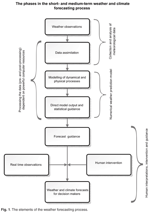
The third phase is concerned with converting the output from numerical models into information of practical value for users. Model outputs—mostly deterministic forecasts—are currently used either directly or are post-processed by statistical methods to produce forecast guidance that can be interpreted and modified by forecasters using their understanding of meteorological principles and incorporating recent observations. The benefits of a forecasting system to a particular user depend not only on the intrinsic skill of the forecast itself but also on knowledge of how the user wishes to use the information and how sensitive his operations are to the weather.4 To calculate a user's risk profile, the probability that a specific forecast weather condition will occur is required. Probabilistic forecasts, derived from an ensemble prediction system (EPS), have substantial added value up to seven days ahead and contribute significantly to the economic benefit of risk management weather forecasts as well as warnings.4
The input phase
The more accurately the initial or current weather condition can be described, the better the numerical prediction models are able to predict a future state. The accuracy of the initial state can be improved by increasing the quantity as well as the quality of surface and upper-air observations and by refining the data assimilation process.
Observational data
Observational data include conventional in situ surface and upper-air observations, those using new technologies such as drifting weather buoys, wind profilers and AMDAR (aircraft meteorological data relay) data, and remote-sensing data via satellites.
Surface observations
The backbone of the global observing network is and will remain the surface observing network that provides surface temperature, humidity, wind and pressure data via more than 12 000 daily reports (during 2004)5 from conventional and automatic weather stations on land. The coverage of this network in 2004 in relation to the desired minimum level, as defined by the Regional Basic Synoptic Network (RBSN), was nevertheless deficient, representing a global average of only 77%.5 The availability of reports was low for Africa (53% of the surface area), particularly over the central parts, and South America (62%), and clearly shows deficiencies in the collection of data and acquisition of reports at night.5 Surface data impact studies performed at the European Centre for Medium-Range Weather Forecasts (ECMWF) found that the absence of surface-pressure observations led to marked biases and large rootmean-square (RMS) forecast errors.6 This work noted that surface data are important elements of the current observing system and essential in anchoring the surface-pressure field. To enhance the accuracy of the initial model conditions, a concerted effort is needed to increase the number of automatic weather stations over the deficient areas together with the use of reliable cellphone or satellite communication systems.
Observations reported by voluntary observing ships (VOS) in the data-sparse areas at sea are even more essential. During October 2004, only 2845 surface ship observations were received on average each day at the main World Meteorological Organization (WMO) global centres; of these, only 312 reports (<11%) were from the southern hemisphere.5 The daily average number of VOS reports has not changed significantly during the period 2000–04 (Fig. 2) and the prospect for improvement is slim.
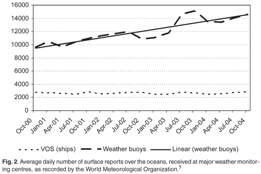
The implementation of the WMO's programme of drifting weather buoys has gone a long way to alleviate the lack of surface observations over the vast ocean areas, however, particularly in the southern hemisphere. The availability of reports from buoys almost doubled during the last six years and the distribution between the two hemispheres is almost equal (Fig. 2). In October 2004, on average 7693 buoy reports (53% of the total) were received daily from the northern hemisphere and 6848 reports (47%) from south of the equator.5
There is a statistically significant improvement in model performance when sea-surface observations are used in data assimilations.6 The effect is greater in the northern hemisphere in winter, when buoy and ship reports were found to be of equal importance. The use of superior temporal resolution of surface pressure (hourly observations instead of six-hourly reports) also improved model performance, especially over the North Atlantic and the southern oceans.7 During the 2005/06 financial year, the South African Weather Service (SAWS) supported the WMO's Drifting Buoy Programme and deployed 36 weather buoys in the South Atlantic.7
Upper-air observations
In situ observations to determine the three-dimensional structure of the atmosphere are conducted using radiosondes. This instrument, attached to a weather balloon filled with hydrogen, takes readings of pressure, temperature and humidity in various layers of the atmosphere. The upward and sideways movements of the balloon are tracked using a global navigation system to derive wind direction and speed in the different layers.
According to the WMO report on implementation,5 the average number of upper-air reports increased from 64% to 67% of the minimum level recommended by the RBSN between 2002 and 2004. This is still far from ideal, with little prospect of much further improvement. The southern hemisphere has a much lower percentage of stations than the northern, and the data-sparse areas over some parts of Africa, Asia, South America and the southern oceans will probably persist for the time being.
The upper-air data available to the ECMWF varied considerably over the past 50 years. Overall, 802 upper-air observations were available in October 1961 at the main synoptic hour for upper-air analyses. These reports were predominantly (97%) from the northern hemisphere, Australia and New Zealand. The number of available reports grew to 1874 in January 1976, with about 15% coming from the southern hemisphere. This number was drastically reduced to 561 by February 1997,9 mainly because the Omega navigation system ceased to track the radiosondes. These instruments then had to be modified at some expense to be able to use the GPS navigation system.
The reliance on upper-air observations in the northern hemisphere has diminished over the last few years and satellite data, rather than radiosonde data, now have a greater influence on the accuracy of NWP products than in previous Observing System Experiment (OSE) studies.10 The benefits of using satellite data in the southern hemisphere is much greater than north of the equator and account for the current quality of forecasts in the south approaching those in the north.10 Upper-air observations remain important, however, especially over land areas where radiance data from satellites are unreliable. Research has shown that radiosonde data are particularly important in the troposphere and that the decline (for financial reasons) of upper-air data over Siberia had an adverse effect on the 500-hPa analysis over the North Atlantic.6
AMDAR data
The aircraft meteorological data relay programme is a cost-effective means of using commercial aircraft to obtain substantially more data in the vertical dimension and over data-sparse areas. This programme was introduced by the WMO about nine years ago and has proved to be a great success. The daily average number of reports grew from about 9000 in October 1996 to more than 28 000 in October 2004.5 From studies conducted in the United States, Petersen11 concluded in 2004 that, despite the significant amount of satellite and conventional upper-air data available in the northern hemisphere, data from ascending and descending aircraft provided a notable advantage for NWP north of the equator at the time. Since then, the average number of reports received globally has increased to more than 200 000 per day.12
The AMDAR programme was successfully implemented In South Africa. Thanks to a partnership between SAWS and South African Airways (SAA), arrangements were made to have several aircraft in the SAA fleet fitted with AMDAR software. During the last six months of 2005, the number of SAA aircraft producing AMDAR reports reached 28, of which 13 are used on the long-haul and 15 on domestic and regional routes. The number of reports has increased from about 370 per day in 2000 to more than 3000 daily in December 2005.
The increase in availability of meteorological data over the subcontinent and surrounding oceans has been dramatic. The number of airfields within the region where at least two aircraft-based vertical profiles per day are generated, has risen from 2 to at least 14. The number of sites providing vertical soundings (AMDAR and conventional records) in southern Africa has expanded from 8 to 18.8 Furthermore, there has been a marked increase in the number of vertical profiles recorded at Cape Town (12 per day), Durban (10) and, especially, at Johannesburg's O.R. Tambo International Airport (31 daily) (M. Edwards, pers. comm.).
Satellite data
There has been a significant increase in the quantity and quality of satellite observations used in NWP during the past 10 years. The ECMWF employed up to 28 satellite data sources in 2005.13 More important, however, is the change in the way that satellite data are being used at the main NWP centres (see later).
Satellite observations are the source of radiance data now being used directly in data assimilation procedures. All atmospheric processes are ultimately driven by solar energy and an accurate representation of the energy balance between the Earth's surface and the atmosphere is essential for both weather forecasting and climate research. Recent OSE studies10 at the ECMWF show that there is a much stronger dependence on satellite data in NWP applications than before. The way in which satellite observations are currently being used in NWP has extended the range of useful weather predictions in the southern hemisphere from five to eight days.
These studies also demonstrate that satellite data now confer greater benefits on NWP in the northern hemisphere than previously found experimentally, and that this is even more than that of radiosondes and wind profilers combined. Furthermore, NWP forecasts in the southern hemispheric are now almost as good as north of the equator, due mainly to the availability of satellite data in the south. The reduced RMS errors of short-range wind and temperature forecasts confirm the value of satellite observations.
Data assimilation
The data assimilation process is an important component of the first phase of weather forecasting. In the early years of numerical weather prediction, weather data were analysed according to the principles of optimum interpolation. The final analysis was a weighted compromise between the observations and the so-called first-guess fields.3 This method had certain weaknesses, however; it did not cope well with the increased amounts of non-conventional data coming from remote-sensing instruments on board weather satellites in the early 1990s. These observations were in the form of radiances that had to be converted into temperatures and humidity before being used in the analysis. The use of these observations was beneficial in the southern hemisphere but not in the northern, where these data were even ignored for a while, because of the greater availability of upper-air radiosonde data.
Noteworthy improvements in forecasting were achieved with the introduction of the three-dimensional variational assimilation (3D VAR) procedure in 1996, followed by the four-dimensional variant (4D VAR) in 1997.3,6 The VAR system works according to a procedure that modifies background errors using model dynamics over the assimilation period.3 The four-dimensional VAR system extends its three-dimensional predecessor by including the time dimension. In this assimilation process, all data within a 12-hour period are used simultaneously in one global (iterative) estimation process. The 4D VAR aims to find the 12-hour forecast that best fits the available observations.
The single most significant improvement in the forecast accuracy of numerical models during the past decade can be attributed to changes in the way that vertical sounding observations (specifically TIROS Operational Vertical Sounder data) from satellites were used in data assimilation. This development was spearheaded by work done at the U.K. Meteorological Office and at the ECMWF.13 Instead of converting the radiances measured by satellites to temperature and humidity, they are used directly in data assimilation procedures.3
At the WMO's Commission for Basic Systems meeting in St Petersburg in 2005,7 twenty recommendations were advanced for the evolution and further improvement of the space-based subsystem of the Global Observing System. These proposals call for the calibration of instruments and more timely data with a greater temporal and spatial resolution. More specifically, satellite agencies should continue to provide and improve vertical air-temperature and radiance profiles, sea-surface temperatures, humidity and wind profiles, sea-surface wind data, estimates of precipitation, aerosol distribution and accurate measurements of cloud-top and cloud-base heights.
Second phase of the weather forecasting process
Numerical weather-prediction models play a dominant part in the second phase of the weather forecasting process.
Numerical weather prediction models
Six basic, or primitive, equations are used to describe the dynamical processes in the atmosphere.13 Two are diagnostic equations: first, an equation of state gives the relationship between pressure, density and temperature; second, a hydrostatic equation describes the relationship between air density and the decrease of pressure with height. The hydrostatic equation is an approximation of the real atmosphere and is valid only for horizontal scales greater than 20 km.
The four other (prognostic) equations are:
• the equation of motion, which describes the movement of air particles in the atmosphere;
• the thermodynamic equation, which describes the adiabatic temperature changes of an air particle during vertical displacements;
• the equation for the conservation of moisture, which takes the losses or gains due to condensation, precipitation and evaporation into account.
Much of the energy driving atmospheric motions comes from long-wave radiation. The energy balance is calculated using the following climatological and geographical fields defined in the numerical model: the model orography, the land–sea 'mask', sea-surface temperature, the albedo, aerosols in the atmosphere, surface vegetation, soil type, soil moisture, the roughness of the surface, snow cover and sea-surface conditions.13 All physical processes in the atmosphere due to its interaction with the Earth's surface are included in the prediction models. These processes include incident solar radiation, outgoing long-wave radiation, turbulence, friction, the formation, occurrence and influence of clouds, convective activities, and the absorption of energy by land and water surfaces.13
The development of global NWP models
Bengtsson2 gives a comprehensive account of the history of NWP, dividing its development into four phases. The first is characterized by the ongoing evolution of barotropic and simple baroclinic models over limited spatial areas. The second phase covers the period from 1960 to the mid-1970s, when hemispheric models based on the primitive equations describing the dynamical motions of the atmosphere were gradually implemented. In addition, models simulating the general circulation of the atmosphere were developed. The useful predictive skill of these models over most of the northern hemisphere was extended from a day or two in the 1950s to about three days through the 1960s and 1970s. During the third phase, the integration domain was extended over the whole globe and models to resolve climate simulations became feasible. This was achieved by the establishment of a global observing system and the rapid increase in computing power. Useful prediction over the extratropical latitudes of the northern hemisphere was extended to 6–7 days by 1991. The corresponding period for the southern hemisphere was only 4–5 days.3 The lack of useful predictions for a longer periods south of the equator was attributed to the limited availability of upper-air observations over large areas of ocean.
The fourth phase, starting in the early 1990s, was driven by the enormous increase in computing power available. Better and more sophisticated data assimilation systems became possible as well as ocean–atmosphere coupled models. More focus was placed on efforts to reduce errors in the initial state of the model. Operational forecasts have improved greatly since the turn of the century. These advances came about through better data assimilation, the greater numbers of improved satellite observations, refinements in the way physical processes are represented, and from superior vertical and horizontal resolution in the models. Global models with a horizontal resolution of 40 km and with 60 vertical levels became a reality, so that useful predictions of about 7 days were achieved for both hemispheres.6
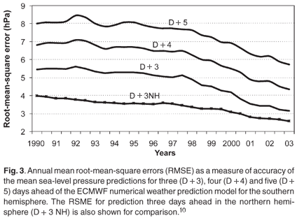
Figure 3 shows recent improvements in the accuracy of mean sea-level pressure predictions, for three, four and five days ahead, of the ECMWF NWP model for the southern hemisphere. The three-day prediction for the northern hemisphere is shown for comparison.10
In February 2006, the ECMWF upgraded its operational forecasting system from the T511L60 global model to the higher-resolution T799L91 model. This meant that the effective horizontal resolution was improved to 25 km and vertical levels were increased to 91. The mean verification scores, which measure accuracy, were generally better for the higher-resolution model. The greatest improvements with the highest statistical significance were in the southern hemisphere—statistically significant verification scores for forecasts up to seven days ahead were calculated for the southern hemisphere in contrast to only three days or less for north of the equator.14
The development of operational NWP models in South Africa
South African research on NWP models started in the late 1950s with the visit of A.P. Burger to Sweden.15 This culminated in a joint NWP research project between the South African Weather Bureau (the forerunner of SAWS) and the CSIR that led to the running of a single-level barotropic forecasting model in research mode.16–18 The first operational 500-hPa barotropic NWP model was run in 1969 on an IBM 1130 computer at the Weather Bureau in Pretoria.19 Although the 500-hPa forecast was moderately useful, the data coverage over the oceans around South Africa was too sparse to define the initial model conditions adequately.
The next significant step in operational NWP in South Africa came about with the installation of the Control Data Cyber 74 computer at the Weather Bureau in 1975. This represented a major increase in computing power. As part of the procurement of the system, the Weather Bureau obtained a five-level, primitive-equation model for the southern hemisphere together with a data-analysis program based on pattern recognition techniques. This NWP system was operated from early 1976 to mid-1980.20 NWP research was focused on the development of alternative models with only limited success.
The development that most affected the use of NWP products in South Africa was the establishment, in the early 1980s, of two World Area Forecast Centres, in Washington, D.C., and at Bracknell in the U.K., by the International Civil Aviation Organization. Model-output fields became freely available and the Weather Bureau was obliged to use the numerical guidance of the U.K. global model for all aviation-related forecast products. In addition to the contributions from Bracknell and Washington, the ECMWF distributed numerical predictions of surface pressure and 500-hPa height fields up to five days ahead via the WMO's Global Telecommunication System. The operational use of these products improved weather forecasting in South Africa significantly, particularly up to four days in advance. Thus, this model enabled the Weather Bureau to predict, three days ahead, the September 1987 floods over KwaZulu-Natal and the 1988 floods over the central parts of the country.
While the NWP products from Washington and Bracknell were used in all the forecasting offices in South Africa, the operation of locally developed NWP models during this time was less effective. The Weather Bureau acquired a new hemisphere model to replace the old Primitive Equation Hemisphere model, but the rest of the system (analysis, assimilation and postprocessing procedures) had to be developed in-house. A lack of the requisite skills and of an adequate computer hampered the project and jeopardised the implementation of the new model.
The acquisition of a Cray YMP-1 supercomputer in 1993 was the beginning of a new growth phase in NWP in South Africa. At the time, the Weather Bureau obtained a complete suite of forecasting programs from the U.S. National Weather Service. The prediction model in the suite was the current state-of-the-art, 'step-mountain', the so called Eta-model.20 It took six months to implement this limited-area model over southern African and surrounding areas, covering 17 levels in the vertical and with an 80-km horizontal resolution.20 Various upgrades were introduced over the next ten years. The model was last upgraded in July 2003, when the horizontal resolution was 32 km and the vertical levels had been increased to 45. The root-mean-square error (RMSE) of the 48-hour prediction of the mean sea-level pressure diminished to an average of 2.18 hPa.
In May 2006 the South African Weather Service, the successor to the Weather Bureau, upgraded its supercomputer facility to the NEC SX8, and planned to run a 12-km resolution, 38-level southern African version of the Unified Model, under licence from the U.K. Meteorological Office, from January 2007. Early results showed great promise, particularly for forecasting precipitation. The high horizontal resolution of the model, which allows improved representation of the topographic features of southern Africa, is having a significant impact on the accuracy of forecasts. The average RMSE of the new model was 1.45 hPa for the first three months of 2007. The latest theoretical work in numerical modelling conducted locally involves the development of a new, nonhydrostatic atmospheric model by researchers at the University of Pretoria.21
It is important to note that the operational weather forecasts issued by the South African Weather Service have, from the mid-1980s, been based largely on model output guidance received from the weather services of the U.S. and U.K., as well as from ECMWF and local models. Local models also depend on the initial and boundary conditions received from America and recently also from Britain. The remarkable improvements in accuracy of the global models over the southern hemisphere, as mentioned above, have had a positive influence on the reliability and accuracy of the weather forecasts over southern Africa. On numerous occasions over the past two to three years, SAWS has successfully warned of high-impact weather changes up to four days in advance. Warnings of this type were not possible ten years ago. However, perceptions of the accuracy of weather forecasts by most users, not only in South Africa but worldwide, probably did not change to the same extent as did the model guidance. Perhaps the reason is that the weather service does not translate the model guidance clearly enough in terms of risk-management information that users can apply directly in their daily decisions.
The output phase
The third and last phase in the weather-forecasting process is aimed at converting model output into useful and understandable information. Forecast guidance can come directly from either the model outputs or statistical modifications of the outputs which do not need any further interpretation for some applications. However, the provision of weather-focused, risk-management information is not straightforward.
A proper evaluation of the benefits of a forecast to a particular user does not depend on the intrinsic skill of the forecast alone, but also requires knowledge of the user's needs and vulnerability to the weather. The relationship between skill and value is complex and interdisciplinary in nature.4 The most important element in determining the value of risk-management information is the level of confidence attributable to a particular forecast.
Ensemble forecasting is currently being used by the principal weather centres and by the South African Weather Service to produce probabilistic forecasts. This kind of forecasting is based on the notion that small errors in the initial conditions of a model run may affect the large-scale flow during the course of the forecast period to a variable extent.13 Forecast models are run from slightly different initial conditions and the model-output fields are statistically analysed to obtain the most probable outcome(s). The outputs of the ensemble system are used to estimate the probabilistic distribution of the most important weather elements.13
It is important that concerted research and development in South Africa is undertaken to ensure that the users and decision makers are provided with the best possible weather-related risk-management information. The further use of ensemble forecasting techniques in this regard is highly recommended.
Conclusions
The accuracy and reliability of operational NWP systems improved significantly during the last ten years, particularly in the southern hemisphere. These advances were achieved primarily by the refinement of data-assimilating processes, the introduction of new or improved types of observation, the enhancement of the physical parameterisation procedures, and also the superior vertical and horizontal resolutions of the models. Further advances in the quality of forecast guidance during the next ten years are likely and should be achieved by increasing the spatial and temporal resolution of surface observations in data-sparse areas as well as by refining the use of remote-sensing information in the models.
The provision of risk-management information using ensemble-forecasting techniques has the potential to add significantly to the economic value of weather forecasts.
I thank Elsa de Jager for her assistance with this article.
1. Wiin-Nielsen A. (1991). The birth of numerical weather prediction. Tellus 43A-B, 36–52. [ Links ]
2. Bengtsson L. (2000). Half a century of numerical weather prediction – an extraordinary scientific and technological achievement. World Weather Watch Technical Report 19, 21–44. [ Links ]
3. Bengtsson L. (1991). Advances and prospects in numerical weather prediction. Q. J. R. Meteorol. Soc. 117, 855–902. [ Links ]
4. Richardson D.S. (2000). Skill and relative economic value of the ECMWF ensemble prediction system. Q. J. R. Meteorol. Soc. 126, 649–667. [ Links ]
5. World Meteorological Organization (2005). World Weather Watch, Twenty-second Status Report on Implementation. Geneva. [ Links ]
6. Thépaut J-N. and Kelly G. (2004). Some surface data impact studies at ECMWF. In Proc. 3rd WMO workshop on the impact of various observing systems on numerical weather prediction, eds. H. Böttger, P. Menzel and J. Pailleux, 112–122. [ Links ]
7. World Meteorological Organisation (2005). Annex to paragraph 5.1.3 of the general summary : Implementation plan for the evolution of space-and surface-based subsystems of the Global Observing System. In Proc. 13th Session of the WMO Commission for Basic Systems, St Petersburg, WMO-No. 985, 116–128. [ Links ]
8.South African Weather Service (2006). Annual Report 2005/06. Pretoria. [ Links ]
9. Persson A. (2005). Observations. In Proc. WMO Course, Brasilia, 24–30 January 2005. [ Links ]
10. Kelly G., McNally T., Thépaut J-N. and Szyndel M. (2004). Observing system experiments of all types in the ECMWF operation system. In Proc. WMO Workshop on Impact of Various Observing Systems on NWP. Alpbach, Australia, 9–12 March. [ Links ]
11. Petersen R. (2004). Summary of impact tests of automated wind/temperature reports from commercial aircraft. In Proc. WMO Workshop on Impact of Various Observing Systems on NWP. Alpbach, Australia, 9–12 March. [ Links ]
12. Purdom J.F.W. (2006). Report of the chairperson of the Open Programme Area Group on Integrated Observing Systems. In Proc. Extraordinary Session of the WMO Commission for Basic Systems, Seoul, 9–16 November. [ Links ]
13. Persson A. and Grazzini F. (2005). User guide to ECMWF forecasts. Met. Bull. M3.2, version 4.0. ECMWF. Reading. [ Links ]
14. Untch A., Miller M., Hortal M., Buizza R. and Janssen P. (2006). Towards a global meso-scale model: The high-resolution system T799L91 and T399L62 EPS. ECMWF Newsl. 108, 6–13. [ Links ]
15. Burger A.P. (1960). First steps in dynamical weather prediction. Technical Report, WB25, South African Weather Bureau, Pretoria. [ Links ]
16. Triegaardt D.O. (1962). The application of dynamic methods of weather prediction to the South African forecasting problem. SAWB Newsl. 174. [ Links ]
17. Triegaardt D.O. (1964). An experimental numerical forecast with a divergent barotropic model. SAWB Newsl. 33-36. [ Links ]
18. Triegaardt D.O. (1965). Experimental barotropic forecasting over subtropical regions. Notos 14, 3–16. [ Links ]
19. Triegaardt D.O. (1969). A new section in the research branch of the Weather Bureau. SAWB Newsl. 96–99. [ Links ]
20. Jordaan W., Poolman E.R., Krige A., Tennant W., Riphagen H., Gertenbach J. and Bruyere C. (1998). The South African Weather Bureau's numerical modelling experience. Internal report, RES/57, South African Weather Bureau, Pretoria. [ Links ]
21. Engelbrecht F.A., McGregor J.L. and Rautenbach C.J. de W. (2007). On the development of a new nonhydrostatic atmospheric model in South Africa. S. Afr. J. Sci. 103, 127–134. [ Links ]

