


Services on Demand
Article
 English (pdf)
 Article in xml format
 Article references
Indicators

Related links
-
 Cited by Google
 -
 Similars in Google
Share

 Permalink
South African Journal of Science
On-line version ISSN 1996-7489
Print version ISSN 0038-2353
S. Afr. j. sci. vol.103 n.7-8 Pretoria Jul./Aug. 2007
SAEON REVIEWS
Progress towards marine ecosystem observing systems in South Africa
Coleen L. MoloneyI, *; Frank A. ShillingtonII
IZoology Department and Marine Research Institute, University of Cape Town, Private Bag X3, Rondebosch 7701, South Africa
IIOceanography Department and Marine Research Institute, University of Cape Town
ABSTRACT
Marine ecosystem observing systems combine measurements, observations and models through a data management and interpretation process to provide information on the status of marine ecosystems. Both biotic and abiotic aspects of the marine environment need to be considered. Single variables typically can be used to represent aspects of the physical and chemical environment, but ecosystem indicators are required for the living components. There are no true marine ecosystem observing systems globally, because most observing systems focus on the physical environment. In South Africa, some fledgling systems are being developed, using the knowledge base provided by focused marine ecosystem research over the past 30 years. Further development should be based on international guidelines, which highlight three interrelated elements: (i) Measurements, obtained directly from ships, drifters or buoys, or remotely from satellites. In South Africa, sustained, long-term measurements are hampered by limited available ship's time, lack of suitable instruments, and insufficient qualified personnel. (ii) Models and other analytical tools to augment observations. South Africa is making progress in marine modelling, but not in marine data assimilation; qualified persons need to be attracted, trained and retained. (iii) Archived and disseminated data generated from measurements and models. The infrastructure and human and institutional capacity for data management and communication in South Africa needs to be enhanced. Existing programmes contribute towards the development of an effective marine ecosystem observing system, but its sustainability requires support at an institutional level.
Introduction
Some steps have been taken towards developing marine ecosystem observing systems in South Africa,1 although there remain several challenges. We use the term 'marine ecosystem' here to denote the physical, chemical and biological components of the ocean and their interactions in the region from the shore to the shelf break (at approximately 500-m depth). We therefore distinguish between systems that consider only physical, chemical or biological components, and discuss the future development of those designed to integrate measurements of all three. This can be achieved through ecosystem indicators, and we show how past ecosystem research has provided a strong foundation for their development and use.2 In South Africa, some advances have been made towards marine ecosystem monitoring. We propose that international best practice be adopted in further developing marine ecosystem observing systems,3 and we describe the elements required for such systems. Current challenges and future needs for implementation in South Africa are also outlined.
The vision of the Global Ocean Observing System (GOOS) involves 'a world where the information needed by governments, industry, science and the general public to deal with marine related issues, including the effects of the ocean upon climate, is supported by a unified global network to systematically acquire, integrate and distribute oceanic observations, and to generate analyses, forecasts and other useful products'.4 This global vision is equally relevant at the national scale. South Africans should be able readily to access information about the state of the oceans, and the marine plants and animals that sustain fisheries, livelihoods, and the health of marine ecosystems.5 This information should be routinely updated and improved through the unified efforts of government departments, industry and science, and by international collaboration.
Two decades ago, this vision would have seemed impossible. However, the rapid development of information technology now makes such systems not only possible, but a reality in some disciplines (for instance, the Indian Ocean Tsunami Warning System6). Much of this work is taking place under the umbrella of GOOS,4 which was initially developed as an open ocean system with a strong bias towards physical oceanography and measurements of physical variables (for example, sea temperatures, currents, and sea-surface elevation). However, the importance of the coastal and inshore environments and their resources has highlighted the need for coastal observing systems in shelf and inshore waters. The critical role of biological components in mitigating or amplifying global change, requires these components to be included in ocean observing systems. Thus, although the development of the open ocean system was pushed by technology and science, the evolution of the coastal ocean system is being pulled by societal requirements,7 namely, the need for (i) improved safety and efficiency of marine operations, (ii) control and mitigation of the effects of natural hazards (e.g. tsunamis, storm surges), (iii) improved capacity to detect and predict effects of global change on coastal ecosystems, (iv) reduced public health risks, (v) more effective protection and restoration of healthy ecosystems, and (vi) the restoration and maintenance of living marine resources.
These six societal objectives are related through a hierarchy of interactions and feedbacks, which add to the difficulty of making the right measurements and interpreting them correctly. Marine ecosystem observations represent an enormous challenge: the ecosystems are complex and there is a seemingly infinite number of variables that could be measured. However, parallel developments in fisheries science have identified the need to manage fisheries ecologically and much progress has been made in identifying ecosystem indicators to track the processes involved.8 In the South African context, this has merged with the need for ecological observations of our marine environment: thus ecosystem indicators have been proposed as the fundamental informational input for an ecosystem observing system which serves both functions.1
Marine ecosystem research programmes in South Africa
In the South African marine environment there are few observing programmes that measure abiotic and biotic variables together, and those that exist are generally small in scope with unproven sustainability.5 For example, Ocean Research Africa9 is a medium-term monitoring programme which supports ongoing research projects on the shelf and the shelf edge of the east coast of southern Africa and the Mozambique Channel. Both physical and biological oceanography are included in the programme, which involves collaboration among government and private institutions and incorporates data measurements and modelling. Limited data are available, mainly in the form of plots, updated when possible.
In contrast to the situation for marine ecosystem observing systems, South Africa has a rich history of marine ecosystem research, especially off the west coast (Table 1). This knowledge base is facilitating the development of ecosystem observing systems in the region, as a result of both improved understanding and a legacy of time-series measurements and monitoring programmes.10 These ecosystem research programmes date back to the late 1970s, when coordinated interdisciplinary, multi-institutional research efforts developed within the framework of the (then) Cooperative Scientific Programmes of the Council for Scientific and Industrial Research. By 1981, a formal research partnership was established among government departments, universities and museums through the creation of the Benguela Ecology Programme (BEP). During the next two decades, the BEP and its associated structures directed many aspects of the research carried out in the pelagic ecosystem off the west coast.11 This research primarily focused on pelagic fish and their recruitment variability, and it led to the development of a conceptual model of the life history of the anchovy, Engraulis encrasicolus.12 This model highlighted the role of transport, by ocean currents, of fish eggs and larvae in determining pelagic fish recruitment. It resulted in several transport studies being initiated, and has recently been modified and extended to apply also to the sardine, Sardinops sagax.13 With diminished overall funding in recent years for marine research in South Africa, the funding for personnel to coordinate research programmes and institutional linkages has also been reduced. Hence these functions have been weakened and are maintained in a less formal manner than previously.
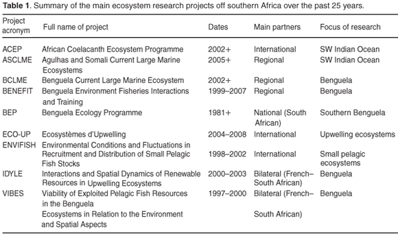
At the same time that local research funding decreased, international research collaborations gained impetus. Bilaterally funded South African–French ecosystem research programmes started in 1997 with the Viability of Exploited Pelagic Fish Resources in the Benguela Ecosystems in Relation to the Environment and Spatial Aspects (VIBES) project.14 This evolved into the IDYLE project (Interactions and Spatial Dynamics of Renewable Resources in Upwelling Ecosystems), completed mainly in 2004. The VIBES/IDYLE projects were co-funded primarily by the French Institut de Recherche pour le Développement (IRD), the South African Marine and Coastal Management (a branch of the Department of Environmental Affairs and Tourism), and the University of Cape Town (UCT). This research cooperation continues through the Ecosystèmes d'Upwelling (ECO-UP) project, which continues until 2008. These projects use generic tools such as geographical information systems, numerical models, and satellite remote sensing, and one of their important legacies is the transfer of up-to-date methods and technology to South African marine researchers, skills crucial for developing and maintaining observing systems. The IDYLE project applied a three-dimensional hydrodynamic computer model to the oceans off southern Africa;15 computer-based investigations of physical and biological processes13,16–19 are now possible in the region. Food web models addressed spatio-temporal dynamics of populations and were used to develop and test ecosystem indicators,20 laying a foundation for assessing ecosystem states on a continuing basis.
The Environmental Conditions and Fluctuations in Recruitment and Distribution of Small Pelagic Fish Stocks (ENVIFISH) project was funded by the European Union for three years, running from 1998 to 2002. It involved a partnership among six European countries and the three countries adjacent to the Benguela Current upwelling system: Angola, Namibia and South Africa. The main objective of ENVIFISH21 was to develop appropriate methods for improving the sustainable management of small pelagic fisheries in the Benguela–Angola region. The project focused on identifying and quantifying key environmental conditions that influence fluctuations in fish recruitment and distribution. One of the main products of the project was the compilation of a large database of satellite remote-sensing data and field measurements. These data were used in a novel modelling approach using self-organizing maps22,23 to help identify spatial patterns in the environment, such as the seasonal variation of vertical profiles of chlorophyll. The results of this research allow the prediction of synoptic integrated chlorophyll concentrations based on surface data from satellites, thereby providing a proxy for plant abundance in the ecosystem.24
The Benguela Environment Fisheries Interactions and Training (BENEFIT) regional partnership, between Namibia, Angola and South Africa, focuses on fisheries and the marine resources of the Benguela Current ecosystem off southwest Africa. It is funded from a variety of local, regional and international research and development sources (notably Norway and Germany).25 BENEFIT was adopted by the Southern African Development Community as a project in June 1996, formally inaugurated in April 1997, and started in 1999. The overall goal of BENEFIT is to promote the sustainable utilization of the living resources of the Benguela Current ecosystem. Its associated research projects aim to increase knowledge of fluctuations in the important living marine resources of the Benguela Current, and enhance understanding of the ways in which environmental factors influence these fluctuations. The project emphasizes training26 in order to develop human capacity and the development of infrastructure to support marine science and technology in the countries bordering the Benguela ecosystem, particularly in Angola and Namibia. An important aspect has been a drive to provide system-wide data and information for input to management of both national and shared resources. These data management activities have the potential to contribute to a marine ecosystem observing system.
The Benguela Current Large Marine Ecosystem (BCLME) project27 adopted a large-scale ecosystem perspective, covering research and other activities in the BCLME region stretching from Cape Agulhas to northern Angola. The programme is funded by the Global Environment Facility through the United Nations Development Programme. In addition, the three countries involved have invested in the programme and funds also have been contributed from other sources, such as the BENEFIT project (see above). The implementation phase of the BCLME programme began in March 2002. The programme is designed to improve the ability of Namibia, Angola and South Africa to deal with environmental problems occurring across national boundaries, so that the BCLME can be managed as a whole. These transboundary issues include (i) uncertainties about ecosystem status and yields in a highly variable environment, (ii) the migration, or straddling, of valuable fish stocks across national boundaries, (iii) the introduction of invasive alien species via the ballast water of ships moving through the region, and (iv) pollutants or harmful algal blooms transported by winds and currents from the waters of one country to another. The BCLME programme has promoted the development of forecasting capabilities in the region,28 and existing observing systems have developed wholly or partly under BCLME guidance.5
The African Coelacanth Ecosystem Programme (ACEP)29 is an offshore programme on the east coast of South Africa, started in March 2002 and still ongoing. It is coordinated by the South African Institute for Aquatic Biodiversity, with the main funders being the Department of Science and Technology, the Department of Environmental Affairs and Tourism, and the German government. The programme has regional coverage throughout the southwest Indian Ocean. Although it has a single species (the coelacanth) as its focus, the programme has facilitated the study of deep, rocky reef ecosystems.30–32 Notwithstanding the ACEP programme, ecosystem research on South Africa's south and east coasts has occurred on a much smaller scale than on the west coast. It is anticipated that this research will benefit from the new Agulhas and Somali Current Large Marine Ecosystems project that started being implemented in 2007.
Marine ecosystem observing systems in South Africa
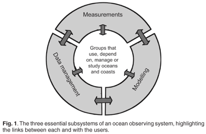
According to the recommendations of the coastal panel of GOOS,3 an operational observing system must routinely and continuously provide required data and information in the form and on the time scales specified by users. Observing systems should consist of three linked, essential elements (Fig. 1) necessary for monitoring (sensing, measuring), data acquisition, management and dissemination, and data assimilation and analysis, including modelling.3 Each of the three elements or subsystems will be described in more detail below in the context of ecosystem observations in South Africa. Although some existing South African platforms have been designed to meet specific needs, they do not contain all three required elements, and thus are not considered fully operational observing systems. Furthermore, none of the existing platforms provides an appropriate suite of indicators for evaluating ecosystem status. However, local observing systems act as prototypes that can be augmented in the future and used to guide the development of other such systems.5
The subsystem for monitoring
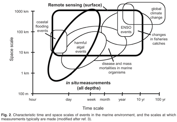
Marine ecosystems clearly are different from terrestrial ones. One of the important differences relates to the difficulties of 'observing' ecosystems in the ocean. Most ocean measurements therefore require expensive survey programmes, including the deployment of moorings and measurement buoys, the use of ship's time and other advanced technologies, such as towed measuring instruments and autonomous underwater vehicles. There is also a very wide range of time scales relevant to marine ecosystems. Biological organisms range from microbes to whales, with corresponding turnover times of hours to decades, whereas the physical components range from tides to the global conveyor belt, with time scales from hours to centuries. This range of scales means that variability on one scale could represent substantial environmental change on another, depending on the issue that is being addressed. For example, a change from normal environmental conditions to those dominated by a harmful algal bloom can occur over days to weeks (Fig. 2). Although potentially devastating for local aquaculture, this kind of change represents normal variability if one is considering the average production of the ecosystem over years and decades. End users interested in harmful algal blooms would require the measurement subsystem to communicate the necessary variables to the data management subsystem (Fig. 1) in a different form from that required by an end user interested in interannual variability.
A pilot measuring system with a monitoring buoy to allow early detection of harmful algal blooms on the west coast of South Africa has been deployed in the Lamberts Bay region since 2003 as part of the BCLME joint programme between Marine and Coastal Management and the Department of Oceanography at UCT. A small, locally designed and instrumented buoy (with two hyperspectral radiometers, a 30-m digital thermistor chain in the vertical, a fluorometer, and an ADCP**) is attached to the moorings. This multi-sensor, lightweight coastal buoy approach has been able to provide high-frequency point sampling in real time, since January 2005.33 These in situ marine observations, at a local point in space, are augmented by ocean measurements from space-borne sensors on satellites, which give good spatial measurements of sea-surface temperature, wind speed and direction, wave heights, ocean currents, and chlorophyll pigments. Ocean ecosystem monitoring using satellite remote sensing that occurs with near-real-time reception of daily 1-km MERIS data, is made possible by international collaboration through the EU Coastwatch programme and the European Space Agency. An important aspect of this BCLME project is the archiving of 250-m resolution MERIS ocean colour data, and the locally processed AVHRR sea-surface temperature and MODIS data through the UCT Remote Sensing Unit.
Past technologies were not capable of making rapid, repeated, synoptic measurements, as occurs routinely today. For the future, remote sensing is a priority for marine ecosystem observations, although this needs to be coupled with judicious deployment of research ships, to ground-truth the remote 'measurements'. In situ coverage is limited in space and time. However, fisheries research cruises by Marine and Coastal Management occur on a regular basis, and these could be used strategically to service an observing system. There is also a need to deploy fixed moorings and autonomous floats, as well as to acquire and retain the technical support to service these.
The State of the Ecosystem Information System (SEIS) is a recently established web site (http://seis.sea.uct.ac.za/index.php) that aims to provide up-to-date information about the state of the natural environment, the state of living marine resources, the impacts of mining, drilling activities and pollution, and the present health of the ecosystem in the Benguela Large Marine Ecosystem region. The project is funded by the BCLME programme. At the time of writing, this system was still in its infancy, especially the ecosystem component, which is using a limited suite of single-and multiple-variable indicators to illustrate changes in the state of the ecosystem.
The accessing and distribution of remotely sensed satellite data (sea-surface temperatures, altimetry, ocean colour) are currently fulfilling a need in the southern African region, although lack of funds and of a cohesive infrastructure and staffing plan hinder the usefulness of some of the current initiatives.5
The subsystem for data acquisition, management and dissemination
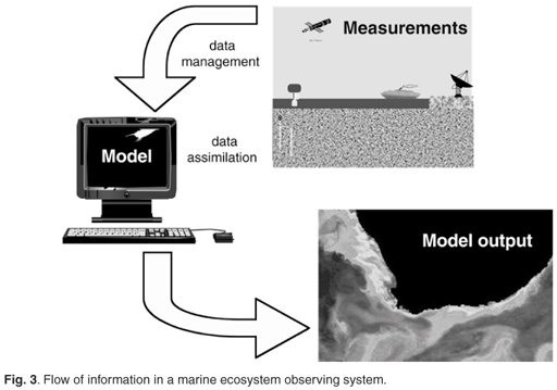
Information flow is at the heart of an observing system, and the data management subsystem is a crucial component of this aspect (Fig. 3). Models are required for predictions, but these models need to be informed and constrained by data that are available at the appropriate times and with assured quality. Data need to be communicated in real-time, near-real-time and delayed mode from many sources, and in many output formats, including processed data and model data. A user-friendly interface is needed to allow users and contributors to access data and provide raw and processed data to the system, which should include effective quality assurance and quality control mechanisms.
Data collected through South Africa's existing and past marine ecosystem research programmes are presently archived in various ways. Marine and Coastal Management has its own internal management system for data collected on research cruises. Much, but not all, of the physical and chemical data are sent to the Southern African Data Centre for Oceanography (SADCO, http://sadco.csir.co.za/). SADCO stores, retrieves and manipulates multidisciplinary marine, largely physical information from areas around southern Africa. There is no unified system in place for managing biological data. At Marine and Coastal Management, the biological data are maintained in-house, but the data management systems are patchy and much information is in danger of being lost because of storage using technology no longer accessible. Many ecosystem data are still held by the researchers who were responsible for their collection. There are also no systems for archiving and distributing model data, and mechanisms of quality assurance and quality control are often lacking. Current capabilities of handling and communicating data should be enhanced through the development of a critical mass of marine data managers, and formalized cooperation and partnerships among institutions to facilitate transfer of data and data products.5
The subsystem for data assimilation and analysis, including modelling
The marine environment is generally under-sampled, and this situation is unlikely to change; the oceans are too large, and measurements are too expensive. Models are an effective means to link understanding of mechanisms and processes to observations, thereby filling in data gaps and ensuring consistency among disparate measurements. This process of blending time-dependent dynamic models and observations is referred to as data assimilation.
In South Africa, there have been several models applied to aspects of marine ecosystems, but models capable of predicting ecosystem states are still being researched and developed worldwide. There is unlikely to be a single model that will adequately address ecosystem issues. Instead, it is necessary to develop a toolbox of models, each designed with its own objectives, the outputs of which can be used to inform and constrain other models. The existing South African ecosystem toolbox contains examples of numerical ocean models as well as numerous biological models. A modelling framework using rule-based approaches has been proposed for combining the outputs of these and other models with observations, to assist in determining and monitoring the state of the ecosystem.1 This work is in a research phase and is continuing. There is a need to progress from the research phase to a forecasting mode, and the models themselves need to be strengthened by data assimilation (Fig. 3).
Conclusions: Harnessing marine observations for science and society
A context for marine ecosystem observing systems is provided by the global shift towards an ecosystem approach to fisheries management. This shift is also influencing and being influenced by other global efforts, such as the development of a coastal module for the Global Ocean Observing System. Ecosystem research is conducted on long time scales, and drivers of ecosystem change can be local (for instance, overfishing) or remote (such as climate change). Detection of changes in marine ecosystems, as for others, requires the devising of ecosystem indicators, which should be linked directly to management objectives.34 Current and past ecosystem research projects have been used to inform and develop policy in terms of resource management, and have positioned the country to be able to respond to the current global need for an ecosystem approach to management. Implementation capabilities, however, remain weak.5 The South African Environmental Observation Network (SAEON) is well positioned to make a strong contribution as a coordinated national effort supported by government departments. In the short term, this effort should address gaps in the availability of skills, technology and information. As a first step, existing capabilities in in situ ocean measurements and remote sensing should be consolidated and enhanced. In the longer term, dissemination and archiving of data should be coordinated and strengthened, guided by international best practice (e.g. as described for GOOS). Developing tools to analyse and interpret measurements and data obtained from models ultimately depends on a skilled workforce, which should be partly funded through private sources. This will require continuing, effective communication strategies to engage end users, to showcase potential products and to identify user needs.
We thank SAEON for the opportunity to participate in the first SAEON summit. Logistical and financial support was provided by the University of Cape Town and the South African Network for Coastal and Oceanic Research, funded by Marine and Coastal Management and the National Research Foundation.
1. Jarre A., Moloney C.L., Verheye H.M., Shannon L.J., Fréon P., van der Lingen C.D., Roux J-P, Hutchings L. and Cury P. (2006). Detecting and forecasting long-term ecosystem changes. In Benguela: Predicting a Large Marine Ecosystem, eds L.V. Shannon, G. Hempel, P. Malanotte-Rizzoli, C. Moloney and J. Woods, pp. 239–272. Elsevier, Amsterdam. [ Links ]
2. Cury P., Shannon L.J., Roux J-P, Daskalov G, Jarre A., Moloney C.L. and Pauly D. (2005). Trophodynamic indicators for an ecosystem approach to fisheries. ICES J. mar Sci. 62, 430–442. [ Links ]
3. UNESCO (2003). The Integrated Strategic Design Plan for the Coastal Ocean Observations Module of the Global Ocean Observing System. GOOS Report No. 125, IOC Information Document Series No. 1183. Paris. [ Links ]
4. IOC (1998). The Global Ocean Observing System Prospectus 1998. GOOS Report No. 42. UNESCO, Paris. [ Links ]
5. Brundrit G., Bartholomae C., Fidel Q., Johnson A. and Guddal J. (2006). Towards a future integrated forecast system. In Benguela: Predicting a Large Marine Ecosystem, eds L.V. Shannon, G. Hempel, P. Malanotte-Rizzoli, C. Moloney and J. Woods, pp. 375–385. Elsevier, Amsterdam. [ Links ]
6. ODINAFRICA. Ocean data and information network for Africa. Online: http://www.vliz.be/vmdcdata/iode/index.php. [ Links ]
7. UNESCO (2005). An Implementation Strategy for the Coastal Module of the Global Ocean Observing System. GOOS Report No. 148; IOC Information Document Series No. 1217. Paris. [ Links ]
8. Cury P.M. and Christensen V. (2005). Quantitative ecosystem indicators for fisheries management: an introduction. ICES J. mar. Sci. 62, 307–310. [ Links ]
9. Ocean Research Africa. Online: http://www.oceanafrica.com/ [ Links ]
10. Hutchings L. et al. (in press). National marine fisheries and environmental monitoring programmes. S. Afr. J. Sci. [ Links ]
11. Moloney C.L., van der Lingen C.D., Hutchings L. and Field J.G. (2004). Contributions of the Benguela Ecology Programme to pelagic fisheries management in South Africa. In Ecosystem approaches to fisheries in the southern Benguela, eds L.J. Shannon, K.L. Cochrane and S.C. Pillar, pp. 37–51. [ Links ] Afr. J. mar. Sci. 26. [ Links ]
12. Hutchings L. (1992). Fish harvesting in a variable, productive environment – searching for rules or searching for exceptions? In Benguela Trophic Functioning, eds A.I.L. Payne, K.H. Brink, K.H. Mann and R. Hilborn, pp. 297–318. [ Links ] S. Afr. J. mar. Sci. 12. [ Links ]
13. Miller D.C.M., Moloney C.L., van der Lingen C.D., Lett C., Mullon C. and Field J.G. (2006). Modelling the effects of physical-biological interactions and spatial variability in spawning and nursery areas on recruitment of sardine in the southern Benguela ecosystem. J. Mar. Sys. 61(3-4), 212–229. [ Links ]
14. Home page of the VIBES/ IDYLE project. Online: http://sea.uct.ac.za/idyle/ [ Links ]
15. Penven P., Roy C., Brundrit G.B,, Colin de Verdiére A., Fréon P., Johnson A.S., Lutjeharms J.R.E. and Shillington F.A. (2001). A regional hydrodynamic model of upwelling in the southern Benguela. S. Afr. J. Sci. 97, 472–475. [ Links ]
16. Huggett J.A., Fréon P., Mullon C. and Penven P. (2003). Modelling the transport success of anchovy Engraulis encrasicolus eggs and larvae in the southern Benguela: the effect of spatio-temporal spawning patterns. Mar. Ecol. Prog. Ser. 250, 247–262. [ Links ]
17. Mullon C., Cury P. and Penven P. (2002). Evolutionary individual-based model for the recruitment of the anchovy in the southern Benguela. Can. J. Fish. Aquat. Sci. 59, 910–922. [ Links ]
18. Mullon C., Fréon P., Parada C., van der Lingen C.D. and Huggett J.A. (2003). From particles to individuals: modeling the early stages of anchovy in the southern Benguela. Fish. Oceanogr. 12, 396–406. [ Links ]
19. Parada C. (2003). Modeling the effects of environmental and ecological processes on the transport, mortality, growth and distribution of early stages of Cape anchovy (Engraulis encrasicolus) in the Benguela System. Ph.D. thesis, University of Cape Town, South Africa. [ Links ]
20. Cury P. and Shannon L.J. (2004). Regime shifts in upwelling ecosystems: observed changes and possible mechanisms in the northern and southern Benguela. Prog. Oceanogr. 60, 223–243. [ Links ]
21. Barange M. and Nykjaer L. (2003). ENVIFISH: an EU/Southern Africa collaborative project investigating environmental causes of pelagic fisheries variability. Progr. Oceanogr. 59, 177–179. [ Links ]
22. Richardson A.J., Risien C. and Shillington F.A. (2003). Using self-organizing maps to identify patterns in satellite imagery. Prog. Oceanogr. 59, 223–239. [ Links ]
23. Richardson A.J., Silulwane N.F., Mitchell-Innes B.A. and Shillington F.A. (2003). A dynamic quantitative approach for predicting the shape of phytoplankton profiles in the ocean. Prog. Oceanogr. 59, 301–339. [ Links ]
24. DeMarcq H., Richardson A.J. and Field J.G. (in press). Primary production of the southern Benguela by combining SeaWIFS data on a self-organizing map predicting vertical chlorophyll profiles. Mar. Ecol. Prog. Ser. [ Links ]
25. BENEFIT. Home page of the Benguela Environment Fisheries Interaction and Training Programme. Online: http://www.benefit.org.na/ [ Links ]
26. Bailey G.W., Boyd A.J., Duncombe Rae C.R., Mitchell-Innes B. and van der Plas A. (2001). Synthesis of marine science research in the Benguela Current system during cruises linked to the BENEFIT training programme in 1999. S. Afr. J. Sci. 97, 271–274. [ Links ]
27. BCLME. Home page of the Benguela Current Large Marine Ecosystem Programme. Online: http://www.bclme.org/ [ Links ]
28. Shannon L.V., Hempel G., Malanotte-Rizzoli P., Moloney C. and Woods J. (eds) (2006). Benguela: Predicting a Large Marine Ecosystem. Elsevier, Amsterdam. [ Links ]
29. ACEP. Home page of the African Coelacanth Ecosystem Programme. Online: http://www.acep.co.za/ [ Links ]
30. Ribbink A.J. and Roberts M. (2006). African Coelacanth Ecosystem Programme: an overview of the conference contributions. S. Afr. J. Sci. 102, 409–415. [ Links ]
31. Heemstra P.C., Fricke H., Hissmann K., Schauer J., Smale M. and Sink K. (2006). Interactions of fishes with particular reference to coelacanths in the canyons at Sodwana Bay and the St Lucia Marine Protected Area of South Africa. S. Afr. J. Sci. 102, 461–465. [ Links ]
32. Roberts M.J., Ribbink A.J., Morris T., van den Berg M.A., Engelbrecht D.C. and Harding R.T. (2006). Oceanographic environment of the Sodwana Bay coelacanths (Latimeria chaumnae), South Africa. S. Afr. J. Sci. 102, 435–443. [ Links ]
33. Harmful algal blooms in southern Africa. Online: http://www.hab.org.za [ Links ]
34. Degnbol P. and Jarre A. (2004). Review of indicators in fisheries management – a development perspective. In Ecosystem approaches to fisheries in the southern Benguela, eds L.J. Shannon, K.L. Cochrane and S.C. Pillar, pp. 303–326. [ Links ] Afr. J. mar. Sci. 26. [ Links ]
* Author for correspondence. E-mail: coleen.moloney@uct.ac.za
** Glossary: ADCP, Acoustic Doppler current profiler; AVHRR,Advanced Very High Resolution Radiometer; MERIS, MEdium Resolution Imaging Spectrometer; MODIS, MODerate-resolution Imaging Spectroradiometer

