


Services on Demand
Article
 English (pdf)
 Article in xml format
 Article references
Indicators

Related links
-
 Cited by Google
 -
 Similars in Google
Share

 Permalink
Bothalia - African Biodiversity & Conservation
On-line version ISSN 2311-9284
Print version ISSN 0006-8241
Bothalia (Online) vol.52 n.1 Pretoria 2022
http://dx.doi.org/10.38201/btha.abc.v52.i1.6
ORIGINAL RESEARCH
Ecological factors determining the distribution patterns of Cyrtanthus nutans R.A.Dyer (Amaryllidaceae) in northwestern KwaZulu-Natal, South Africa
Lynne M. RuddleI; Erika A. van ZylII; Jorrie JordaanIII
IP.O. Box 72512, Lynnwood Ridge, Pretoria, 0040
IIGrass and Forage Scientific Research Services, Dundee Research Station, KwaZulu-Natal, Department of Agriculture and Rural Development, P.O. Box 626, Dundee, 3000
IIIP.O. Box 788, Modimolle, 0510
ABSTRACT
BACKGROUND: Cyrtanthus nutans R.A.Dyer is a range-restricted species occurring in northwestern KwaZulu-Natal, South Africa and in Eswatini, and is currently classified as Vulnerable in accordance with the IUCN criteria. Land transformation and disturbance of natural habitats have resulted in an ever-increasing fragmentation of the species' range.
OBJECTIVES: This manuscript provides a description of some of the abiotic and biotic factors associated with the remaining natural populations of C. nutans in the Sour Sandveld and Moist Tall Grassland Bioresource Groups of northwestern KwaZulu-Natal
METHODS: An investigation was conducted in the northwestern KwaZulu-Natal region to determine the effect that key ecological and anthropological determinants have in influencing the distribution and survival of the species. Data collected included sites of occurrence, estimated population numbers, elevation, ecological factors (soils/geology, climate, veld composition), and human/animal activities.
RESULTS: The northwestern KwaZulu-Natal C. nutans populations were found to occur primarily in untransformed veld within the Moist Tall Grassveld, Dry Highland Sourveld and Sour Sandveld Bioresource Groups. It occurs largely on gradients of < 10% on mid- to lower terrain slopes and predominantly within an altitude range of between 1 100 and 1 300 m a.m.s.l.
CONCLUSION: C. nutans occurs in a narrow altitudinal range and has a preference for soils with high nitrogen and organic carbon and low phosphorus and acidity levels.
Keywords: autecology, Dundee fire lily, plant species distribution.
Introduction
Almost a quarter of the ± 20 700 vascular plant taxa indigenous to the Republic of South Africa are threatened with extinction or are of conservation concern (Von Staden et al. 2013; SANBI 2020). Almost all ecosystems in southern Africa have been modified or transformed by human activity (Macdonald 1989), and southern African plant diversity faces several pressures and multiple threats from both sustainable and unsustainable agricultural practices, urbanisation and mining in addition to the uncontrolled spread of alien invasive plants and illegal plant harvesting (Macdonald 1989; Scott-Shaw 1999). The east coast province of KwaZulu-Natal (KZN) is home to 5 261 vascular plant taxa, of which almost 14% are categorised as threatened or of conservation concern (SANBI 2020).
Cyrtanthus nutans R.A.Dyer (Amaryllidaceae), is a deciduous geophyte that reproduces vegetatively or by seed after a short spring flowering period. It is currently classified as Vulnerable B1ab(iii), according to the National Red List categories, with an extent of occurrence (EOO) of 6 067 km2 in only four locations (SANBI 2020).
The first documentation of C. nutans in KZN was by Dr L.E. Codd in 1952, who collected the plants for cultivation. He found the plants and described them as abundant in an area of approximately 8 km2 in the Vants Drift area (latitude 28° 10'S and longitude 30° 31'E), near Dundee. Two years later, Dyer (1954) formally recorded the presence of the plants and taxonomical-ly described the species. The area of occurrence fell within what is now known as the Umzinyathi District Municipality (DM), and were subsequently found in a small area in the adjoining Uthukela DM. This comprises the study area, which extends over some 1 450 km2.
Ten years later the species was located in Eswatini [Swaziland], on the hills around Mbabane above the Komati River, Piggs Peak, by Gordon McNeil (McNeil 1967; Reid & Dyer 1984) and has recently been documented as occurring in the mountains above Barberton, Mpum-alanga, South Africa (SANBI 2020).
Distribution patterns of C. nutans were briefly described in the Dundee area in 2011 (Scott-Shaw 2011: pers. comm.). Indications were that the species was not as abundant as described in the 1952 Dyer report. The probable causes or factors for a reduction in population are not known. Furthermore, in 2006, the unsuccessful translocation of a C. nutans population from a housing development project in the Umzinyathi DM emphasised the lack of information on the specific habitat preferences of the plants. Following these events, informal observations of C. nutans were noted, which eventually led to annual Spring recordings of flowering plants, from 2012 onwards, of distribution sites in Dundee, KZN and surrounding areas. A formal reevaluation of the Dundee C. nutans distribution was undertaken from 2014 onwards, which form the current study (Ruddle 2018).
Materials and methods
Study area description
The study area is characterised by relatively high elevations, sandy soils, sourveld grasslands and sparsely scattered paperbark thorn trees (Vachellia sieberiana). The Bioresource Groups (BRG) that occur in the area are Dry Highland Sourveld, Moist Tall Grassveld, Sour Sandveld and Mixed Thornveld (Camp 1999). The area is typically a summer rainfall region (October to March) with a long-term mean annual rainfall of 749 mm annum-1.
Long term annual rainfall records for the period 1968 to 2016 indicated that the highest and lowest annual recorded rainfall during this period occurred during 2012/2013 and 2014/2015 respectively and occurred during the study period (Agrometeorology 2019).
Data collection
Over a four-year period (2013-2016) during the spring months of September to mid-December, which covers the flowering period of C. nutans, areas within the district municipalities were randomly traversed by motor vehicle and on foot, identifying sites of occurrence. The number of flowering plants, latitude/longitude co-ordinates, altitude and gradient were recorded, and the presence or absence of fire/herbivores or human activities and land use were documented.
Vegetation species composition surveys were carried out at C. nutans sites according to a method described by Camp and Hardy (1999). A 50 χ 50 m square was marked at each site. Within the square, a W-shaped path was traversed, using a sharp stick, of approximately 1.2 m in length, 50 spike-point observations were made. The nearest grass species to the point was identified and recorded.
Soil samples were taken at sites on the basis that no evidence of historical disturbance was noted but were a good representative of the known geology of the area. Using a Dutch auger, samples were taken at a depth of 0-30 cm (Sample A: topsoil, excluding organic material) and depth 30-60 cm (Sample B: sub-soil). The chemical soil analyses were carried out in accordance with standard practices (Manson & Roberts 2001) at the Cedara Feed and Soil Laboratory of the KwaZulu-Natal Department of Agriculture, Environmental Affairs and Rural Development, which is an accredited laboratory.
Data analysis
Co-ordinates of sites of C. nutans occurrence were mapped onto a 1:50 000 digital topographical map and Bioresource Group vegetation map (Ezemvelo KZN Wildlife 2009). The condition of the herbaceous component survey per site was compared with that of a benchmark site to calculate a veld condition per site (Camp & Hardy, 1999). A benchmark site is the most productive of its kind in terms of the highest possible sustained animal production within the Bioresource Groups (BRG) and are pre-described by Camp and Hardy (1999). Climatic data for the study were sourced from the Agricultural Research Council (ARC) (Agrome-teorology 2019) weather station, based at the Dundee Research Station (Comp 30109).
Results and discussion
Sites of occurrence
During the study period, a total of 27 sites, where C. nutans plants occurred, were found over an area of approximately 1 450 km2. In Umzinyathi DM, plants were only located in two of the four Local Municipalities (LM); namely, Endumeni LM and Msinga LM. In Uthukela they were only located in the adjoining Indaka LM near Wasbank. The sites of occurrence were classified into five main groups, according to population densities and basic land use type; namely, Area 1 - urban; Area 2 -semi-urban/industrial/agriculture; Area 3 - semi-urban and agriculture; Area 4 - commercial agriculture; and Area 5 - mixed wildlife/cattle rangeland (Figure 1).
Description of sites of occurrence
Topography
The C. nutans populations were recorded at an altitude range of between 1 031 and 1 459 m a.m.s.l. in an area extending over 1 450 km2. The great majority of plants (97.98%) occurred within the 1 100-1 300 m altitude range (Figure 2).

Slopes and gradients
Most of the C. nutans populations were found on relatively flat grassveld areas with gradients of less than 15° overall (mid- to foot slopes); 75% of the C. nutans populations were found on gradients of less than 10% with no preference for a particular facing slope.
Gradients play a fundamental role in water drainage and the subsequent formation of soils and nutrient deposits on the lower slopes (Gordon 2017; pers. com.). The soil fertility environment of C. nutans is not currently known, however established populations at certain sites may indicate its favourability for the species. Soil acidity levels, clay percentages and nutrient levels based on the soil sample readings, provide an indication of a favourable soil environment (Gordon 2017; pers. com.).
Geological and soil data
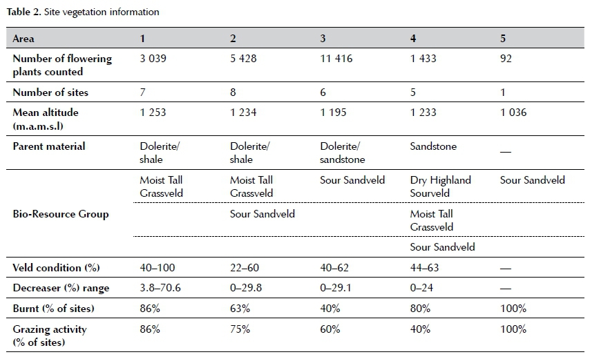
Soil sampling was undertaken in four of the five main areas indicated in Figure 1. The dominant parent rock at the sites was dolerite, with only two sites underlain with shale or sandstone (Table 1). Nitrogen levels were high (>0.16%) in all except one site in Area 3, where subsoil nitrogen levels were too low to measure due to low organic carbon percentages. Low acidity (< 10% acid saturation), high organic carbon percentages (>1.8%) and tolerance of a wide range of textures (15 to 50% clay) and low phosphorous levels appears to be adequate for C. nutans plants.
Vegetation data
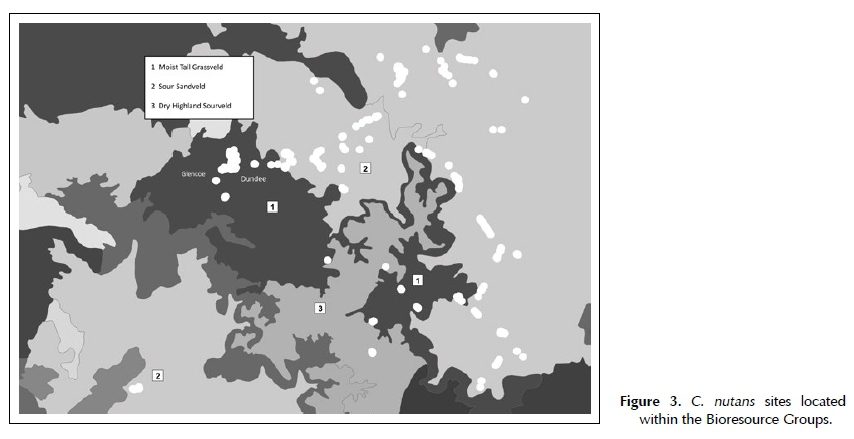
Cyrtanthus nutans were primarily found within the Moist Tall Grassveld (20% of plants counted) and Sour Sandveld (79% of plants counted) with minimal occurrence in Dry Highland Sourveld (1% of plants counted) (Figure 3).
The veld condition assessment for Area 5 was not conducted as further access to the property was unattainable. No clear picture arises from veld conditions compared with number of flowering plants counted since
C. nutans was found in areas where veld conditions ranged from relatively low (22%) to relatively high (one site indicated a veld condition of 100%). A high percentage of sites (40-100%) had been burnt or grazed prior to plant emergence (Table 2).
Population size
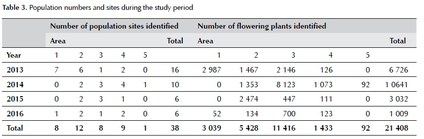
Most of the flowering plants were located in Area 3 (53%) and Area 2 (25%), with fewer populations in Area 1 (14%), Area 4 (7%) and Area 5 (1%). As the study progressed, fewer new sites plant populations and flowering plants were identified (Table 3).
Anthropological influences
Large scale fragmentation of an already restricted range was evident with the distribution of C. nutans. Population sites were distributed primarily on the periphery of arable land, in natural veld situated outside of fenced agricultural properties, along road reserves that had not been graded/cleared, and in the narrow band of railway reserves; these areas were not conducive to land transformation. Areas utilised for low intensity grazing over long-term periods were predominantly well populated with C. nutans. Only sites situated in Areas 1 and 2 (urban and semi-urban) indicated some form of human activity in terms of pedestrian and vehicular thoroughfares, dumping of building materials, graded road reserves and the subsequent damage to plants and habitat fragmentation resulting in smaller isolated pockets of plants.
Conclusions
Abiotic and biotic factors associated with the geographical distribution of C. nutans in the Sour Sand-veld and Moist Tall Grassland Bioresource Groups of northwestern KwaZulu-Natal have been documented.
The species occurs within a narrow altitudinal range on relatively flat grasslands on predominantly doler-ite parent rock in soils with moderate nitrogen and organic material, and low phosphorus and acidity levels. Land transformation in the Dundee area has resulted in the fragmentation of C. nutans populations
into smaller isolated pockets. According to Von Staden (2013), the expansion of both urban and agricultural areas in the Dundee area has resulted in a 9% loss of habitat in the past 24 years and C. nutans is threatened by habitat degradation due to crop cultivation and overgrazing.
References
Agrometeorology (ARC-ISCW Agro-Climatology Data Base), 2019, ARC-Institute for Soil, Climate and Water, Pretoria, South Africa. [ Links ]
Camp, K.G.T. & Hardy, M.B., 1999, In: Hardy, M.B., & Hurt, C.R., 1999, Veld in KwaZulu-Natal, Agricultural Production Guidelines for KwaZulu-Natal, Pietermaritzburg: KwaZulu-Natal Department of Agriculture. [ Links ]
Camp, K.G.T., 1999, A bioresource classification for KwaZulu-Natal, South Africa. [ Links ]
Dyer, R.A., 1954, Cyrtanthus. The Flowering Plants of Africa, 30: t 1182. [ Links ]
Ezemvelo KZN Wildlife, 2009, Bioresource topography maps, Ezemvelo KZN Wildlife, Pietermaritzburg, South Africa. [ Links ]
Macdonald, I.A.W., 1989, Man's role in changing the face of southern Africa, in Biotic Diversity in Southern Africa: Concepts and Conservation. Oxford University Press, Cape Town, pp. 51-72. [ Links ]
Manson, A.D. & Roberts, V.G., 2000, Analytical methods used by the soil fertility and analytical services section. Republic of South Africa, Pietermaritzburg. [ Links ]
McNeil, G., 1967, 'A brief introduction to Cyrtanthus', Journal of the Royal Horticultural Society: XCII (4), 180183. [ Links ]
Reid, C., Dyer, R.A. & American Plant Life Society (La Jolla), 1984, 'A review of the southern African species of Cyrtan-thus', American Plant Life Society. [ Links ]
Ruddle, L.M., 2018, Ecological characterisation and effects of fire and grazing on Cyrtanthus nutans (R.A.Dyer) in North-Western Kwazulu-Natal, South Africa, Masters dissertation. [ Links ]
SANBI, 2020, Statistics: Red List of South African Plants version 2020.1, available at http://www.redlist.sanbi.org (Accessed: 13 August 2020). [ Links ]
Scott-Shaw, R., 1999, Rare and threatened plants of KwaZulu-Natal and neighbouring regions, KwaZulu-Natal Nature Conservation Service. [ Links ]
Von Staden, L., Raimondo, D. & Dayaram, A., 2013, Taxo-nomic research priorities for the conservation of the South African flora, South African Journal of Science, 109(3-4), 1-10, https://doi.org/10.1590/sajs.2013/1182. [ Links ]
 Correspondence:
Lynne M. Ruddle
e-mail: lynne.ruddle1@gmail.com
Submitted: 19 May 2021
Accepted: 7 December 2021
Published: 30 March 2022

