


Serviços Personalizados
Artigo
 Inglês (pdf)
 Artigo em XML
 Referências do artigo
Indicadores

Links relacionados
-
 Citado por Google
 -
 Similares em Google
Compartilhar

 Permalink
Bothalia - African Biodiversity & Conservation
versão On-line ISSN 2311-9284
versão impressa ISSN 0006-8241
Bothalia (Online) vol.50 no.1 Pretoria 2020
http://dx.doi.org/10.38201/btha.abc.v50.i1.1
ORIGINAL RESEARCH
http://dx.doi.org/10.38201/btha.abc.v50.i1.1
Long-term changes in forest cover in a global biodiversity hotspot in southern Mozambique
Wataru TokuraI, II; Hermenegildo MatimeleIII; Julian SmitIV; Michael Timm HoffmanI
IPlant Conservation Unit, Department of Biological Sciences, University of Cape Town, Rondebosch, Cape Town 7701, South Africa
IIJapan Wildlife Research Center, 3-3-7 Kotobashi, Sumida-ku, Tokyo, 130-8606, Japan
IIIHerbarium, Instituto de Investigação Agrária de Mogambique, C.P. 3658, Maputo, Mozambique
IVSchool of Architecture, Planning and Geomatics, University of Cape Town, Rondebosch, Cape Town 7701, South Africa
ABSTRACT
BACKGROUND: Deforestation is a complex and dynamic process of widespread concern in sub-Saharan Africa that is influenced by a range of social, economic and biophysical factors.
OBJECTIVES: The aim of this study was to analyse patterns of deforestation and its potential drivers in the Licuáti Forest Reserve, a biodiversity hotspot in southern Mozambique, between 1990 and 2016.
METHOD: We performed image classification on Landsat imagery at six time steps and interviewed local community members to understand the spatial pattern and rate of forest cover loss over time. We also examined changes in the incidence of fire.
RESULTS: A substantial increase in the rate of deforestation since 1990 was detected in this vulnerable thicket vegetation. The probability of deforestation was significantly higher near the major roads, where houses are located. This suggests that the proximity of human settlements to the forest, and access to charcoal markets in urban areas, influenced the spatial pattern. Two key factors, charcoal production and the establishment of settlements and agricultural lands, were identified as proximate causes of deforestation. In addition, fires associated with these two causes might amplify the loss of forests in the area.
CONCLUSIONS: Complex interactions between the drivers of deforestation and socioeconomic factors were suggested, as most of the charcoal produced in the region is transported to Maputo. Ongoing road improvements and infrastructural development in the region will likely accelerate the decline in forest cover in the future. This has implications for the biodiversity of the region as well as for the sustainability of local livelihoods, as they often depend on forest products for their daily uses.
Keywords: charcoal production; deforestation; Maputaland; remote sensing; traditional authority
Introduction
Deforestation is a major environmental concern in sub-Saharan Africa. However, it is a complex and dynamic process influenced by many different social, economic and biophysical factors (Geist & Lambin 2002; Kleemann et al. 2017; Woollen et al. 2016). In addition, the sustainability of forest resources is influenced by the type of disturbance, the ability of different species to regrow, and by climatic conditions (Tredennick & Hanan 2015; Wollen et al. 2016). While some of the drivers of deforestation (e.g. population growth and rapid urbanisation) might be common within a region or continent (Geist & Lambin 2002; Hosonuma et al. 2012; Rudel 2013), its impact on local livelihoods is likely to be case specific (Woollen et al. 2016).
Because of the various functions and roles of forests, the effect of deforestation can result in a decline in essential ecosystem services (Ryan et al. 2016). These include the provision of timber and water, climate regulation, carbon sequestration, and the safeguarding of biodiversity (Hansen et al. 2013; Millennium Ecosystem Assessment 2005; Turner, Lambin & Reenberg 2007). In sub-Saharan Africa, a reduction in forest cover can also directly affect the livelihoods of millions of people. Rural households often depend on many different goods and services from forests, including fuelwood, food, and medicine for their domestic use or as a source of income (e.g. Bandyopadhyay, Shyamsundar & Baccini 2011; Cavendish 2000). Furthermore, in urban areas, charcoal derived from forest trees is still a major energy source used for cooking (Zulu & Richardson 2013). Past studies have suggested that charcoal production, fuelwood extraction, timber harvesting and the expansion of agricultural fields are key proximate causes of deforestation. These factors, in turn, are influenced by several important socio-economic changes in a country or region, such as population growth, urbanisation and economic growth (Ahrends et al. 2010; Burgess et al. 2017; Hosonuma et al. 2012; Mayaux et al. 2013; Rudel et al. 2009). The effects of these socio-economic changes on deforestation have been investigated mainly at national scale (e.g. DeFries et al. 2010; Rudel 2013), and regional scale studies are still limited in sub-Saharan Africa (Ryan, Berry & Joshi 2014).
This study focused on the Licuáti Forest Reserve in southern Mozambique. We investigated the historical pattern and rate of deforestation and its potential drivers using remote sensing techniques and an interview survey undertaken with local inhabitants. Due to a diverse biota and high endemism of species, the region has been recognised as a global biodiversity hotspot (Siebert et al. 2002; Steenkamp et al. 2004; Van Wyk 1996). At the same time, the prevalence of extreme poverty is an important social issue, with more than 40% of the rural population living below the poverty line (Alfani et al. 2012; Direcgâo Nacional de Estudos e Análise de Políticas 2010). Many of the rural households in the study area depend on natural resources from the surrounding forests for their livelihoods (Kloppers 2001; Soto, Munthali & Breen 2001). Furthermore, people's livelihoods and forest uses have changed substantially since 1992 when the decades-long civil war ended. The end of conflict triggered rapid economic growth in the country and has led to important changes in land-use practices, such as land and infrastructure development, and increased harvesting of natural resources in the region (Kloppers 2001; McGregor 1998; Siebert et al. 2002). One of the major consequences of the socioeconomic and demographic changes in post-civil war Mozambique has been the rapid loss of forest cover, which declined by 0.58% per annum between 1990 and 2002 (Sitoe, Salomâo & Wertz-Kanounnikoff 2012). Although information about deforestation is available globally since 2000 (Hansen et al. 2013), little is known about the reasons for forest cover change, especially at local-level. Long-term analyses of forest cover change, therefore, need to be contextualised in terms of how anthropogenic pressures might have influenced such changes.
Our aim in this study was to: 1) map and quantify the historical pattern of deforestation in rural southern Mozambique after the civil war to the present (1990-2016); 2) identify potential drivers of deforestation and discuss their effects in a socio-ecological context; and 3) provide future perspectives on how the use of natural resources impacts further on the environment. The results provide fundamental information to better plan and conserve natural resources and livelihoods in the region, as well as to help anticipate potential future changes.
Method
Study area
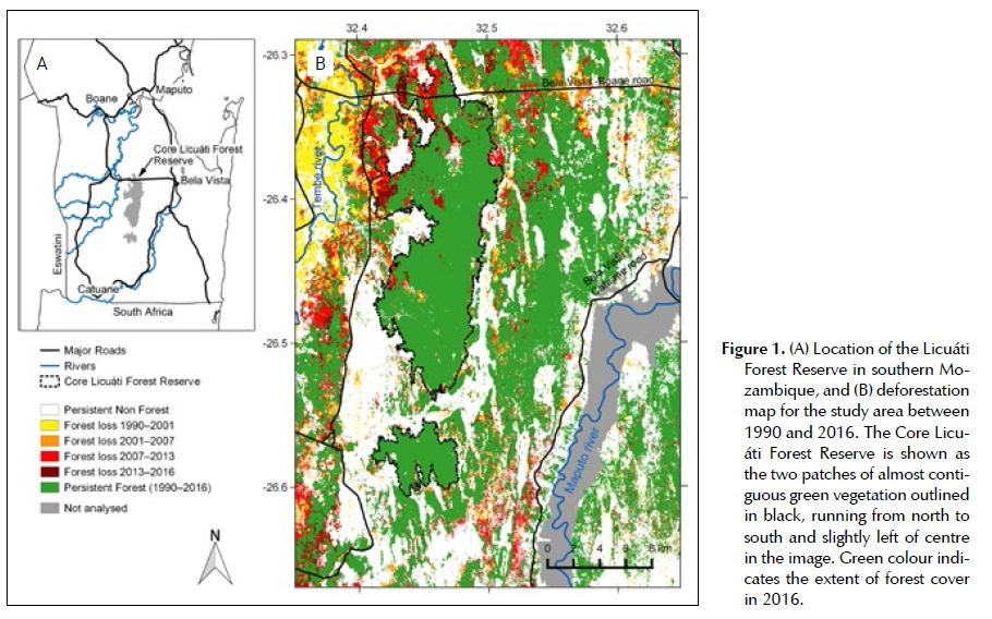
The Licuáti Forest Reserve (LFR) is located in Matutu-ine District in southern Mozambique, approximately 50 km south of Maputo, the capital city of Mozambique (Figure 1A). In southern Mozambique, mean annual rainfall declines from east to west with approximately 1 100 mm falling along the coastline and 600 mm further inland in the LFR (Izidine, Siebert & Van Wyk 2003; Van Wyk 1996). The land is mostly flat and comprises predominantly of aeolian sand. Along the Maputo and Tembe rivers, however, alluvium clayey soils, which are more suitable for farming, are also common (Izidine et al. 2003).
The LFR contains floristically unique Licuáti Thicket (also known as Short Sand Forest) and Licuáti Forest (Tall Sand Forest), and forms the core of the Maputa-land Centre of Endemism. This is a region within the Maputaland-Pondoland-Albany biodiversity hotspot where high levels of endemism and biodiversity have been recognised (Izidine et al. 2003; Van Wyk 1996). At least 35 Maputaland endemic species have been recorded in the LFR, and among these, 20 species have restricted distributions in the reserve (Izidine 2003). Licuáti Thicket is a particularly important habitat for many endemic species in the region. It is characterised by dense woody vegetation in the shrub layer, which occurs to a height of 5-6 m (Gaugris & Van Rooyen 2008). Common species in the shrub layer include Psydrax locuples, P. fragrantissima and Warneckea par-vifolia, while Balanites maughamii and Afzelia quanzen-sis emerge above the canopy. Licuáti Forest has similar species composition but has a taller structure up to 15 m in height. These two vegetation types, Licuáti Thicket and Licuáti Forest, are typically located in a matrix of open woodland dominated by Terminalia sericea, Albi-zia versicolor, Albizia adianthifolia var. adianthifolia or grassland, which is structurally and floristically different (Izidine 2003; Siebert et al. 2002) and does not form part of this analysis.
Historically, the Licuáti Thicket and Licuáti Forest have been considered sacred with logging controlled by traditional leaders (Izidine 2003; Izidine et al. 2008). In 1943, the colonial government designated the area as a forest reserve to protect the commercially valuable Af-zelia quanzensis, which was common in the LFR at the time. The boundary of the LFR is not clearly defined, but widely recognised among local people as the area between Tembe and Maputo rivers and the Bela Vista-Bo-ane and Bela Vista-Catuane roads (Izidine et al. 2009).
During the period of Mozambican civil war (19761992), rural areas in southern Mozambique were depopulated. Many people evacuated to the neighbouring countries or cities, and 72% of the current population of Matutuine District had lived elsewhere during this period (Kloppers 2001; McGregor 1998). The vegetation appeared to have recovered over this period as a result of the lower population and less intense pressure from human activities (Siebert et al. 2002), although charcoal production, which started as early as 1979, continued throughout the war (McGregor 1998). After the ceasefire in 1992, people returned from refugee camps and neighbouring countries and agricultural lands were quickly reopened (Sitoe et al. 2012; Smith et al. 2008).
It has been a concern in recent years that intensified human pressure has caused degradation and deforestation in the LFR. It was reported that the LFR has not been functioning as a reserve due to the lack of effective management and monitoring in recent years (Izidine et al. 2009). The potential direct threats noted were the selective logging of commercially valuable timber species, charcoal production, and land development (Izidine et al. 2003; Siebert et al. 2002). Fires also pose a direct threat to the vegetation of the LFR (Izidine 2003), particularly if they increase in frequency.
Deforestation mapping
Data and pre-processing
A total of six cloud-free and terrain-corrected (L1T) Landsat TM, ETM+ and OLI images were downloaded from USGS Earth Resources Observation and Science (EROS) Center Science Processing Architecture (ESPA) system (https://espa.cr.usgs.gov/) (Supplementary Information, Table 1). Top of atmosphere radiance imagery was used. To reduce error caused by phenological variation, all the images selected were from the late growing season (April to June), when cloud cover was also relatively low. The floodplain along the Maputo River (approximately 15 m in elevation) was excluded from the analysis, because discussions with members of the surrounding communities indicated that most of the land had been used for the cultivation of rice prior to 1990. The images were clipped to encompass the study area, and then six bands were used for the following analysis: RGB, NIR, SWIR1 and SWIR2.
Analysis
A map of deforestation over the period 1990 to 2016 was produced using a combination of unsupervised and supervised image classification techniques. A flowchart of the procedure followed in this analysis is provided in Supplementary Information, Figure 1. Firstly, six bands of each time step of the Landsat image were classified into 30 spectral classes, which could adequately differentiate forest cover across the study site, applying the k-means algorithm of unsupervised classification. Next, the 30 spectral classes were merged into three information classes: forest, not forest, and unknown, based on user knowledge of the area and image interpretation to true-colour composited from the same set of the Land-sat images. In this study, we defined forest as the areas covered by more than 70% by woody plants, and treated Licuáti Thicket and Licuáti Forest as one class (forest). This differentiated the structure of Licuáti Thicket and Licuáti Forest from the other vegetation types (e.g. open woodland). Secondly, a training dataset was generated from the images produced by the previous step. The pixels labelled as 'unknown' at the previous step were excluded from the training dataset. The rest of the pixels were assigned to one of six classes; persistent not forest, deforestation between 1990 and 2001, deforestation between 2001 and 2007, deforestation between 2007 and 2013, deforestation between 2013 and 2016, or persistent forest. For example, a pixel identified as 'forest' in 1990 and then 'not forest' over the period 2001 to 2016 was classed as 'deforestation between 1991 and 2001', and a pixel classified as 'forest' for all five time steps was categorised as 'persistent forest'. This study assumed that after deforestation, the transition from 'not forest' to 'forest' did not occur during the period over which our study took place and pixels indicating regrowth (transition from 'not forest' to 'forest') were excluded from the training data set. This assumption was based on the understanding that Licuáti Thicket and Licuáti Forest are very stable over time (Izidine 2003; Matthews et al. 2001) and has not expanded during the period of analysis. It is also based on our observations in the field of the irreversibility of deforestation and the unidirectional nature of land use change. After this, 300 pixels were randomly selected for each class, and then split into 200 training pixels and 100 validation pixels. Finally, all the Landsat images (six bands, five time steps) were stacked together and a direct supervised classification was performed with a support vector machine (SVM) using 'rasclass' package (Wiesmann & Quinn 2016) in R (ver 3.1.0, R Core Team 2014).
The forest extent and deforested area were estimated from the deforestation map produced following the approach outlined above. The mean annual deforestation rate was calculated using the compound interest formula (Puyravaud 2003, Supplementary Information). The pattern of deforestation was analysed for the entire study area and the floristically important Core Licuáti
Forest Reserve (CLFR) separately. The CLFR was defined as comprising the two biggest patches of the mosaic of Licuáti Thicket and Licuáti Forest, and followed the approach of Izidine (2003) who identified these patches by visual interpretation of aerial photos (Figure 1B). To understand the influence of the roads, the distance from the major roads to each pixel was measured in QGIS (ver 2.10.1 Pisa). From this, the probability of forest loss (response variable) was tested against the distance from the major roads (explanatory variable) using the logistic regression model for each time step. Statistical analysis was implemented in R (R Core Team 2014).
An assessment of accuracy was performed comparing the classified deforestation map and validation dataset. In addition, forest cover in 2013 and 2016 was validated independently using very high resolution imagery from Google Earth (ver 7.1.7.2606, Google Inc) and a true colour composite Sentinel-2 image from the Sentinel Scientific Data Hub (https://scihub.copernicus.eu) captured within four months from the date of the Land-sat imagery.
Visual interpretation of very high resolution images
To understand the causes of deforestation in the LFR, visible disturbances, including fire, charcoal kilns, roads and tracks, were interpreted from very high resolution images from Google Earth and then marked on the map in selected locations. The imagery used for this analysis was taken in early 2000s and September 2015. In addition, the locations of all houses in the study area were recorded from Google Earth images obtained from August to September 2015. In this study a house was defined as an artificial roofed structure larger than 3 m x 3 m. No distinction was made between schools, hospitals, and other public buildings because those were indistinguishable from other dwellings in the satellite images. Then, the point data indicating the locations of houses was raster-ised at 30 m spatial resolution, and the distance from the major roads to each pixel in which a house or group of houses was located, was measured in QGIS (ver 2.10.1 Pisa). To test if the proximity of roads influenced the spatial distribution of houses, the presence or absence of houses in each pixel was regressed against the distance from the major roads using a logistic regression model.
Fire history
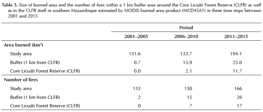
A fire history map was produced using MODIS burned area monthly product (MCD45A1). The data for the period January 2001 to December 2015 were downloaded from Earth Explorer (http://earthexplorer.usgs.gov/), following which burned areas were mapped across the study area. The number of fire occurrences and the size of the burned area were estimated at five year intervals for the study area, for a 1 km buffer area around the CLFR, as well as for the CLFR separately.
Interviews with leaders, government representatives and resource users
Semi-structured interviews were conducted in March 2016 with 30 members of the local community to understand the uses, current regulation, and enforcement of resource use protocols within the LFR. Interviewees included three traditional leaders, one government representative, seven community officials, eight charcoal producers, and 11 other members of the local community. The traditional leaders were selected from Pochane, Jabula and Tinonganine, which are all localities within the LFR. The interviews were undertaken with each community member separately or in small groups of two to five people, depending on the attendance of the interviewees.
Field observations
Fallen trees, charcoal kilns and other processes related to charcoal production were recorded in the field. The location and the number of charcoal bags were also counted along the major roads during the course of traversing the region. Field surveys were undertaken on two separate occasions; in October 2015 and March 2016.
Results
Pattern of deforestation
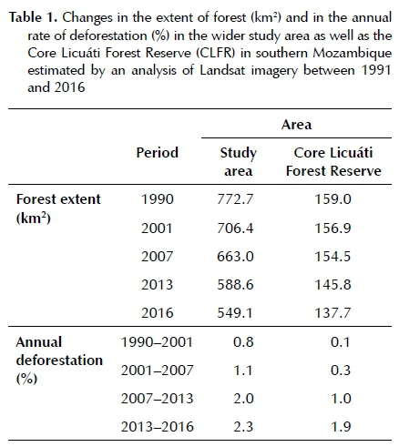
The extent of forest cover in the study area has decreased from 772.7 km2 in 1990 to 549.1 km2 in 2016. The annual rate of deforestation has increased from 0.8% in 1990-2001 to 2.3% in 2013-2016, suggesting intensified deforestation in recent years (Table 1). In the Core Licuáti Forest Reserve (CLFR), the annual rate of deforestation was relatively low and stable before 2007, but has increased since this date to match that of the wider study area. The CLFR has lost 13% of its extent over the past 25 years.
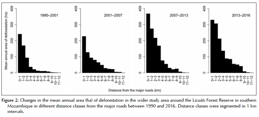
The pattern of deforestation illustrated in Figure 1B shows that more severe deforestation has occurred in the western and northern part of the study area, especially within the area along the Tembe River and the Bela Vista-Boane Road. There was a significant effect of the distance from the major roads on the probability of deforestation for all the periods (p < 0.001, see Table 2 for the details). The deforestation hotspots (i.e. areas of greatest loss in forest cover) have also shifted over the past 25 years. Between 1991 and 2001, forest loss occurred mostly in the area near the Tembe
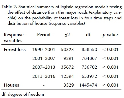
River. However, since 2001, forest loss has taken place at multiple locations near the major roads and has been advancing further from the roads over time (Figure 2).
The overall accuracy of the classification approach used was estimated at 98% while the kappa coefficient was 0.98. An independent accuracy assessment for forest cover based on Google Earth high resolution imagery and Sentinel-2 imagery resulted in an overall accuracy of 86% in 2013 and 91% in 2016 (see Supplementary Information, Tables 2-4 for the details).
Visual interpretation of the disturbances
Multiple human disturbances, including charcoal production, fire, establishment of new settlements and small scale agriculture, were observed in the satellite images (Figure 3). Small scale agriculture and houses were normally found within a short distance from the major roads (Figure 3A, B). Charcoal kilns were mostly located in the CLFR, notably around former emerging trees (Figure 3C). Commonly, charcoal kilns were found prior to the occurrence of larger scale forest clearing (Figure 3A, B). Fires of various sizes were observed from the edge of the forest and thicket as well as near the deforested area.The causes of the fire were not visible from the images, but the location of the burned area implied that charcoal production and land clearing to create open space for agriculture were the major causes of the fires. Typically, the network of roads and tracks penetrated into the CLFR to connect the charcoal kilns, agricultural fields, houses and major roads.
Houses were distributed throughout the study area but were significantly confined to locations near the major roads (p < 0.001, Table 2) (see Supplementary Information, Figure 2). Of the 6,008 houses counted, 51.3% were located within 500 m of a major road. The location of villages and larger settlements overlapped with deforestation hotspots.
Fire history
Frequent fires were observed near the Maputo and Tembe rivers where lands are used predominantly for agricultural production (see Supplementary Information, Figure 3). Fire was recorded only occasionally in the CLFR between 2001 and 2005, and relatively infrequently in the surrounding 1 km buffer during this time step. Over time, however, the trend has been for an increase in fire frequency, especially in the northeastern part of the study area (Table 3). However, many of the relatively small scale fires were not detected in this product, as burned areas observed by the visual interpretation of high resolution images (Figure 3) were not recorded by the MODIS burned area product.
Interviews with leaders, government representatives and resource users
Local inhabitants of the study area indicated that they are allowed to extract resources from the forest including medicinal plants, building material, firewood and charcoal. Many of the respondents suggested that exploitation of forest resources in the study area started before independence in 1975. Resources were mainly exploited to fulfil the basic needs at local level and, because of this, the impacts had been relatively low. However, the rapid increase in human population in both rural and nearby urban areas, together with shortages of food resulting from long periods of drought, has led to the overexploitation of natural resources, particularly wood for charcoal production. Respondents indicated that charcoal produced in the study area is often sold to dealers and transporters from the nearby cities of Matola and Maputo. Currently, the extraction of wood for charcoal production is turning into a small industry.
Local inhabitants also suggested that many people who do not reside in the area have invaded the LFR with more sophisticated equipment, including vehicles and chainsaws, to produce charcoal from the woody plants in the study area.
The Mozambican government has worked closely with local communities within the LFR area in the past to ensure the sustainable exploitation of natural resources. Certain members of the communities were appointed as 'community rangers' and were tasked with patrolling the forest to control fire and illegal timber exploitation, and to avoid the cutting of non-authorised tree species. Trees with edible fruits such as Dialium schlechteri as well as timber species such as Afzelia quanzensis were not allowed to be harvested for the production of charcoal. This regulation is widely recognised among the surrounding communities. For more than 10 years, 12 members of the community from the Pochane area, for example, worked to patrol the forest. However, at present none of them is still active primarily because of a lack of incentives. The absence of community rangers has enabled outsiders to access the CLFR to exploit trees for the production of charcoal regardless of whether they are edible or timber species.
The three traditional leaders interviewed suggested that the sacred sites within the LFR had historically always been respected by local communities. However, the presence of outsiders has meant that the beliefs and practices that preserved some of the forest patches within the CLFR are becoming less effective.
Field observations
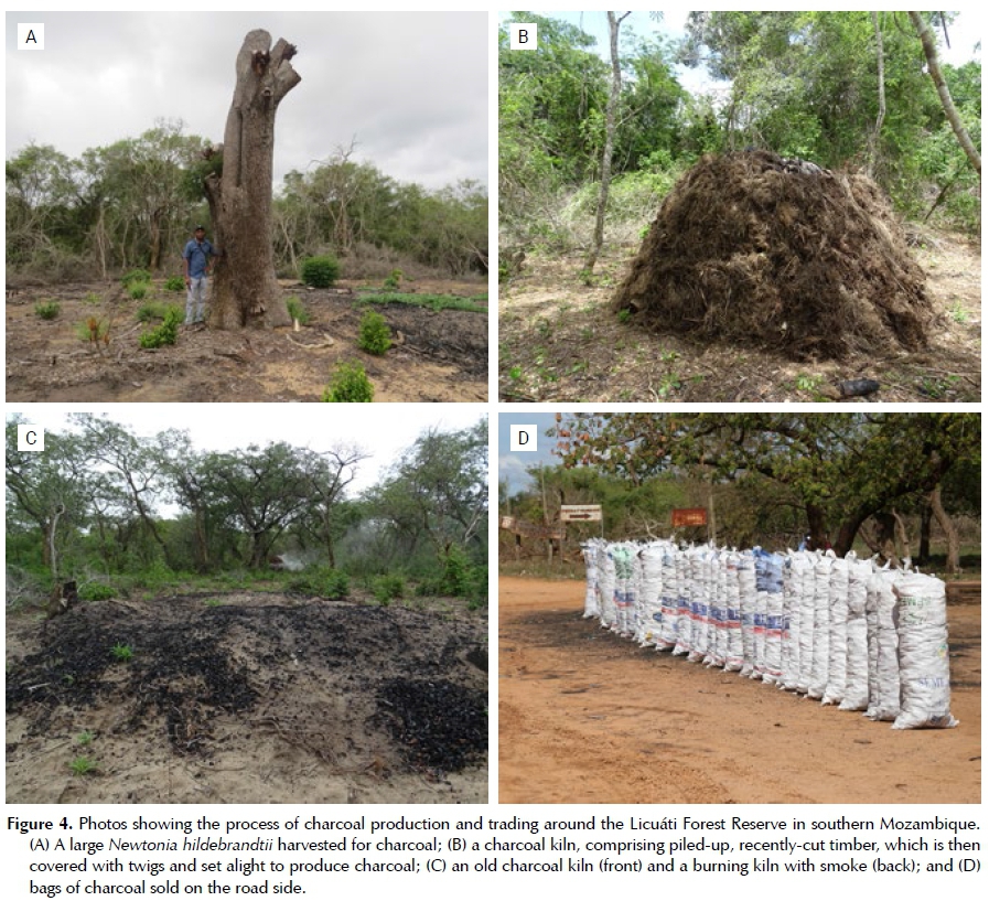
Charcoal kilns were frequently observed in the LFR. Typically, tall trees such as Afzelia quanzensis, Balanites maughamii, Dialium schlechteri and Newtonia hildeb-randtii, with stems larger than 50 cm in diameter were the prime target for the production of charcoal. Usually, all vegetation growing within 10-15 m radius from the target tree was cleared, and all trees with stem diameters larger than 15 cm were cut to produce charcoal (Figure 4A). Cut trees were stacked in mounds 5 to 10 m in diameter and then covered with soil and set alight to create a kiln, which burned for several days (Figure 4B, C). Little recruitment of vegetation was found around the kilns even after several years.
The bags of charcoal collected from the kilns were sold along the main roads, which extend from the large cities (Maputo and Matola) to LFR (Figure 4D; Supplementary Information, Figure 4). A total of 937 and 1 074 bags of charcoal were counted along the major roads around LFR in October 2015 and March 2016 respectively. One bag of charcoal was usually made up of two polypropylene woven bags (each of which is 50 χ 120 cm and commonly used for the containment of 30 kg of grain) stitched together to pack charcoal (Figure 4D). The price of charcoal in March 2016 was 250 MT (approximately USD 5) per bag near the LFR and 600 MT per bag in the urban markets.
Evidence of the use of other natural resources was also observed, including the harvesting of timber for commercial sales, poles for construction materials, and the removal of bark for dye and medicinal purposes. However, the observed uses for these purposes were far less frequent and on a much smaller scale. Thus, their impact on the vegetation in the LFR is considered relatively minor compared to the impact caused by the removal of trees for the production of charcoal.
Discussion
Pattern of deforestation
Forest cover has been continuously reduced in southern Mozambique in the past 25 years as human pressure on the land and on its natural resources has been growing. The rate of deforestation has been accelerating, especially over the past ten years. Although direct comparison is difficult due to differences in methodology and survey periods, our estimates of past (1990-2001) rates for deforestation of 0.1% per annum for the Core Licuáti Forest Reserve (CLFR), and 0.8% per annum for the study area as a whole, were lower than the deforestation rates calculated for the Maputo province between 1990 and 2002, which were recorded as 1.67% per annum (Sitoe et al. 2012). Recent (2013-2016) estimated rates for deforestation of 1.9% per annum for the CLFR and 2.3% per annum for the study area, however, exceeded those figures.
The pattern of deforestation exhibited considerable spatial variation over time. The distribution and shifts in deforestation hotspots suggest that both social and ecological factors influence this pattern. For example, the proximity to major roads, settlements and distribution of alluvial soil along the rivers affect the pattern of deforestation as does the distribution of tall, emergent trees in the Licuáti Thicket. The effects of the social and ecological factors strongly relate to the key proximate causes of deforestation, especially charcoal production, establishment of settlements and increase in agriculture lands.
A series of accuracy assessments confirms overall good matches in the remote sensing analysis. However, the estimated loss in forest cover might either be overestimated, because this study assumed that little regrowth had occurred during the study period, or underestimated because small scale deforestation and degradation may not be sufficiently detected due to limitations in the spatial resolution of the Landsat imagery used in the analysis.
Drivers of deforestation
Charcoal production is the major driver of deforestation in the broader study area as well as within the CLFR.
Large trees have been selectively logged and turned into charcoal on site, and then transported to the cities, such as Maputo and Matola, where many of the households use charcoal as a major source of energy (Puná 2008; Sitoe et al. 2012). Working on the basis that one traditional kiln produces 10-20 bags of charcoal, the volume of charcoal recorded at the roadside alone at one point in time is enough to account for 50-100 kilns (Ellegârd et al. 2002; Puná 2008). More serious deforestation in the area near the major roads and at closer proximity to the settlements suggests that accessibility to these major charcoal markets influences the rate and extent of deforestation. Similar patterns have also been observed in other areas in Mozambique (Jansen, Bag-noli & Focacci 2008; Sedano et al. 2016), as charcoal is usually transported to the cities by trucks, often a few hundred kilometres away from the forests where it is produced (Ellegârd et al. 2002). On the other hand, the effect of other local uses of natural resources is considered minor. For example, local people who collect firewood for cooking usually do not fell large trees in the process (Cuvilas, Jirjis & Lucas 2010; Ellegârd et al. 2002; Sitoe et al. 2012).
Land use/land cover change has occurred mostly at the edges of the forest, especially around the villages, major roads and along the Tembe River. The alluvial clayey soil along the Tembe River is more suitable for agriculture (Siebert et al. 2002; Smith et al. 2008), which probably accounts for why the riverine forest along the Tembe River was the first forested area to be transformed into agricultural land after the ceasefire in 1992. In the CLFR, current land use practices suggest that deforestation due to the establishment of settlements and agricultural lands has been limited to the northwestern part of the reserve. The low agricultural potential of the infertile and water repellent soils of the Licuáti Thicket and Licuáti Forest (Kirkwood 2002; Sie-bert et al. 2002), may prevent its large-scale conversion to agricultural fields. Land already transformed prior to 1990 was likely used for small scale agriculture, grazing for cattle and housing.
Fires have become more frequent in the study area and could have a significant impact on the vegetation in the CLFR. The results suggest that most of the fires observed were initiated in the process of charcoal production, or during the clearing of land either for agriculture or settlements, and then spread causing further loss of forest cover. However, Licuáti Thicket and Licuáti Forest are characterised by having a relatively narrow margin of bare soil extending a few metres from the edge of the vegetation (Matthews et al. 2001). This naturally occurring bare area acts as a fire break and because of this the CLFR has been less impacted by fire than areas outside of the reserve. The long-term effect of fire on the Licuáti Thicket and Licuáti Forest is still unknown. Fire affects seed germination of certain species in the Licuáti Thicket (Kirkwood 2002), but destructive fires in this vegetation type have also been reported (Izidine 2003; Matthews et al. 2001).
While charcoal production and land use/land cover change directly affect the extent and rate of deforestation, indirect effects may facilitate further degradation and deforestation. For example, to enable the transportation of the charcoal, a network of roads and tracks connect recently opened areas. The creation of road networks leads to the further removal of vegetation, and can facilitate the establishment of an agricultural field along the road (Sitoe et al. 2012). Also, as the distance to the large, target trees increases, second-tier, less profitable remaining trees, which are initially overlooked by producers, can be harvested and even relatively degraded forest may be further cleared (Sitoe et al. 2012). These findings highlight the multiple and inter-related causes of deforestation, while the complex linkages make it difficult to isolate the specific influences of different drivers.
The spatiotemporal patterns of deforestation imply that there is an increasing demand for land and for the income that can be derived from the exploitation of natural resources and further points to the unsustainable practice of deforestation. The charcoal producers now migrate further away from cities and roads than ever before to harvest trees and produce charcoal (Ellegârd et al. 2002; Puná 2008), while farmers travel further to clear vegetation to start farming. Many trees in the region grow slowly at rates of only 2-5 mm in diameter per year (Gaugris, Van Rooyen & Bothma 2008; Kirk-wood 2002) and once large trees have been harvested, it will take hundreds of years for saplings to grow to the same size. This unsustainable practice will damage the natural resources of the area and may result in a reduction in the supply of necessary products and services for rural livelihoods, such as fuelwood and medicine, from Licuáti Thicket and Licuáti Forest.
As is the case elsewhere in Mozambique (Ryan et al. 2014; Sitoe et al. 2012), these findings emphasise the importance of socio-economic factors as the underlying causes of deforestation in the region. For example, the demand for charcoal has been boosted by a rapidly growing urban population. From the charcoal supplier side, prevailing poverty in the rural areas and lack of employment have encouraged people to become involved in the charcoal business (Puná 2008; Ryan et al. 2014; Sitoe et al. 2012). People returning home after the civil war, coupled with population growth in the rural areas of southern Mozambique, increased anthropogenic pressure on natural resources in the study area. In addition, a lack of effective management, monitoring and law enforcement, together with the weakened influence of traditional leaders on natural resource use, particularly by outsiders, has also had an effect on these dynamics (Izidine et al. 2008).
Future perspectives
The projected population growth in cities and the provinces in southern Mozambique (Instituto Nacional de Estatística 2010) suggests that there will be continuous and intensifying anthropogenic pressure on natural resources in the future. Moreover, the recently completed road upgrade between the Mozambique-South Africa border and Boane through the Licuáti Forest Reserve, and the completion of the bridge over Maputo Bay, may accelerate deforestation in southern Mozambique by providing better market access to the cities. Without an affordable alternative for charcoal for urban households, the waves of deforestation described by Ahrends et al. (2010) for Dar es Salaam are likely to expand south from Maputo into the wider LFR area as well.
Changes in socio-economic conditions in the future will increase anthropogenic impact on the remaining forests, and may further increase the threats to biodiversity and cause the possible deterioration of rural livelihoods. Deforestation will reduce the habitats of several endemic plant species that have strong affinities with thicket vegetation such as Empogona maputensis, Psy-drax fragrantissima and Warneckea parvifolia. As shown in other studies, tall emerging trees play a disproportionately important ecological role in these forests and will disappear as a result of the selective logging of large individuals. For example, pods of Afzelia quanzensis are known to be a key food source of mammals (Gathua 2000). If deforestation leads to the depletion of the resources, local people will not only lose the source of income, but access to other forest products such as firewood and medicinal plants will also be affected. The forest is also a sacred site, which, if lost, will also affect the cultural identity and practices of the surrounding communities (Izidine et al. 2008, 2009).
Conclusion
The results suggest that the rate of deforestation in the study area is influenced strongly by outsiders who supply the energy needs of the neighbouring urban areas (especially Maputo) with charcoal produced from trees within the wider Licuáti Forest Reserve (LFR) and increasingly, from the Core Licuáti Forest Reserve itself. To slow this impact there is an urgent need to return control of the LFR resources to the surrounding communities themselves and to those responsible for the wise stewardship of the resources of the reserve. The successful community-based forest management strategies, which have worked so successfully to protect the resources of LFR in the past, should be supported and enhanced. There is also a need for new initiatives, such as the provision of solar and gas-generated sources of energy, particularly in the neighbouring cities, to minimise the need for charcoal itself. To inform this, more ecological and socio-economic studies should be undertaken. These include an evaluation of the role of fire in the dynamics of the Licuáti Thicket and Licuáti Forest vegetation as well as an understanding of the livelihood activities that rely on the production and trade of charcoal. A full assessment of the impact of the charcoal trade on local communities will guide effective, equitable and realistic planning in the region.
Acknowledgements
John and Sandie Burrows, Jonathan Timberlake, Domitilla Raimondo and Carol Poole are thanked for their contributions to the study, which was supported in part by the South African National Biodiversity Institute, the University of Cape Town and the Norwegian Environment Agency. Ethics approval for this research was provided by the University of Cape Town's Faculty of Science's Research Ethics Committee under the conditions set out in FSREC-Ethics Approval 07-2016.
Competing interests
The authors declare that they have no financial or personal relationship(s) that may have inappropriately influenced them in writing this article.
Author's contributions
W.T. collected field data in March 2016, analysed the data and wrote the first draft of the manuscript. H.M. facilitated the study and collected field data in October 2015 and 2016. He also led the interviews with community leaders and co-wrote this section of the manuscript and edited and commented on the entire draft. J.S. supervised the remote sensing component of the study and edited the manuscript with a particular focus on the remote sensing analysis. M.T.H. designed the study and assisted with field data collection in October 2015. He also edited the manuscript and co-wrote or re-wrote some of the text where necessary. All authors gave their approval for the final version to be published.
References
Ahrends, A., Burgess, N.D., Milledge, S.A., Bulling, M.T., Fisher, B., Smart, J.C., Clarke, G.P, Mhoro, B.E. & Lewis, S.L., 2010, 'Predictable waves of sequential forest degradation and biodiversity loss spreading from an African city', Proceedings of the National Academy of Sciences of the United States of America 107, 14556-14561. doi: 10.1073/ pnas.0914471107. [ Links ]
Alfani, F., Azzarri, C., D'Errico, M. & Molini, V., 2012, 'Poverty in Mozambique: New evidence from recent household surveys', World Bank Policy Research paper 6217. [ Links ]
Bandyopadhyay, S., Shyamsundar, P & Baccini, A., 2011, 'Forests, biomass use and poverty in Malawi', Ecological Economics 70, 2461-2471. doi: 10.1016/j.ecole-con.2011.08.003. [ Links ]
Burgess, N.D., Malugu, I., Sumbi, P, Kashindye, A., Kijazi, A., Tabor, K., Mbilinyi, B., Kashaigili, J., Wright, T.M., Gereau, R.E., Coad, L., Knights, K., Carr, J., Ahrends, A. & Ne-wham, R.L., 2017, 'Two decades of change in state, pressure and conservation responses in the coastal forest biodiversity hotspot of Tanzania', Oryx 51, 77-86. doi:10.1017/ S003060531500099X. [ Links ]
Cavendish, W., 2000, 'Empirical regularities in the poverty-environment relationship of rural households: evidence from Zimbabwe', World Development 28, 1979-2003. doi: 10.1016/S0305-750X(00)00066-8. [ Links ]
Cuvilas, C.A., Jirjis, R. & Lucas, C., 2010, 'Energy situation in Mozambique: A review', Renewable and Sustainable Energy Reviews 14, 2139-2146. doi: 10.1016/j.rser.2010.02.002. [ Links ]
DeFries, R.S., Rudel, T., Uriarte, M. & Hansen, M., 2010, 'Deforestation driven by urban population growth and agricultural trade in the twenty-first century', Nature Geoscience 3, 178-181. doi: 10.1038/ngeo756. [ Links ]
Direcção Nacional de Estudos e Análise de Políticas (DNEAP), 2010, 'Poverty and wellbeing in Mozambique: Third national poverty assessment', Ministry of Planning and Development, Maputo, Mozambique. [ Links ]
Ellegârd, A., Chidumayo, E., Malimbwi, R., Pereira, C. & Voss, A., 2002, 'Charcoal potential in southern Africa CHAPOSA (Final Report)', Stockholm Environment Institute, Stockholm, Sweden. [ Links ]
Gathua, M., 2000, 'The effects of primates and squirrels on seed survival of a canopy tree, Afzelia quanzensis, in Ara-buko-Sokoke Forest, Kenya', Biotropica 32, 127-132. doi: 10.1111/j.1744-7429.2000.tb00455.x. [ Links ]
Gaugris, J.Y. & Van Rooyen, M.W., 2008, 'A spatial and temporal analysis of Sand Forest tree assemblages in Maputa-land, South Africa', South African Journal of Wildlife Research 38, 171-184. doi: 10.3957/0379-4369-38.2.171. [ Links ]
Gaugris, J.Y., Van Rooyen, M.W. & Bothma, J. du P., 2008, 'Growth rate of selected woody species in northern Ma-putaland, KwaZulu-Natal, South Africa', South African Journal of Botany 74, 85-92. doi: 10.1016/j.sajb.2007.09.001. [ Links ]
Geist, H.J. & Lambin, E.F., 2002, 'Proximate causes and underlying driving forces of tropical deforestation: Tropical forests are disappearing as the result of many pressures, both local and regional, acting in various combinations in different geographical locations', Bioscience 52, 143-150. doi: 10.1641/0006-3568(2002)052[0143:PCAUDF]2.0.CO;2. [ Links ]
Green, J.M.H., Larrosa, C., Burgess, N.D., Balmford, A., Johnston, A., Mbilinyi, B.P, Platts, PJ. & Coad, L., 2013, 'Deforestation in an African biodiversity hotspot: Extent, variation and the effectiveness of protected areas', Biological Conservation 164, 62-72. doi: 10.1016/j.bio-con.2013.04.016. [ Links ]
Hansen, M.C., Potapov, P V., Moore, R., Hancher, M., Turubanova, S.A., Tyukavina, A., Thau, D., Stehman, S.V., Goetz, S.J., Loveland, T.R., Kommareddy, A., Egorov, A., Chi-ni, L., Justice, C.O. & Townshend, J.R.G., 2013, 'High-resolution global maps of 21st-century forest cover change', Science 342, 850-853. doi: 10.1126/science.1244693. [ Links ]
Hosonuma, N., Herold, M., De Sy, V., De Fries, R.S., Brock-haus, M., Verchot, L., Angelsen, A. & Romijn, E., 2012, 'An assessment of deforestation and forest degradation drivers in developing countries', Environmental Research Letters 7, 44009. doi: 10.1088/1748-9326/7/4/044009. [ Links ]
Instituto Nacional de Estatística, 2010, Projecções da População 2007-2040, viewed 24 November 2016 from http://www.ine.gov.mz/. [ Links ]
zidine, S.A. 2003, 'Licuáti Forest Reserve, Mozambique: Flora, utilization and conservation', MSc thesis, Dept. of Wildlife Management, University of Pretoria, South Africa. [ Links ]
zidine, S., Siebert, S. & Van Wyk, B., 2003, 'Maputaland's Licuáti forest and thicket', Veld & Flora 89, June, pp. 56-61. [ Links ]
zidine, S.A., Siebert, S.J., Van Wyk, A.E. & Zobolo, A.M., 2008, 'Taboo and political authority in conservation policy: A case study of the Licuáti Forest in Maputaland, Mozambique', Journal for the Scientific Study of Religion 2, 373-390. doi: 10.1558/jsrnc.v2i3.373. [ Links ]
zidine, S., Siebert, S., Van Wyk, A.E. & Zobolo, A.M., 2009, 'Threats to Ronga custodianship of a sacred grove in southern Mozambique', African Journal of Indigenous Knowledge Systems 7, 182-197. doi: 10.4314/indilinga.v7i2.26435. [ Links ]
ansen, L.J.M., Bagnoli, M. & Focacci, M., 2008, 'Analysis of land-cover/use change dynamics in Manica Province in Mozambique in a period of transition (1990-2004)', Forest Ecology and Management 254, 308-326. doi: 10.1016/j. foreco.2007.08.017. [ Links ]
Kirkwood, D., 2002, 'Floristics and dynamics of Sand Forest, a subtropical dry forest type in South Africa', PhD thesis, Dept. of Botany, University of Cape Town, South Africa. [ Links ]
Kleemann, J., Baysal, G., Bulley, H.N. & Fürst, C., 2017, 'Assessing driving forces of land use and land cover change by a mixed-method approach in north-eastern Ghana, West Africa', Journal of Environmental Management 196, 411442. doi: 10.1016/j.jenvman.2017.01.053. [ Links ]
Kloppers, R.J. 2001, 'The utilisation of natural resources in the Matutuine district of southern Mozambique: implications for transfrontier conservation', MA thesis, Department of Anthropology, University of Pretoria, South Africa. [ Links ]
Matthews, W.S., Van Wyk, A.E., Van Rooyen, N. & Botha, G.A., 2001, 'Vegetation of the Tembe Elephant Park, Ma-putaland, South Africa', South African Journal of Botany 67, 573-594. doi: 10.1016/S0254-6299(15)31188-1. [ Links ]
Mayaux, P, Pekel, J-F., Desclée, B., Donnay, F., Lupi, A., Achard, F., Clerici M., Bodart, C., Brink, A., Nasi, R. & Bel-ward, A., 2013, 'State and evolution of the African rainforests between 1990 and 2010', Philosophical Transactions of the Royal Society B Biological Sciences 368, 2012030020120300. doi: 10.1098/rstb.2012.0300. [ Links ]
McGregor, J., 1998, 'Violence and social change in a border economy: war in the Maputo hinterland, 1984-1992', Journal of Southern African Studies 24, 37-60. doi: 10.1080/03057079808708566. [ Links ]
Millennium Ecosystem Assessment, 2005, 'Ecosystems and human well-being: Synthesis', Washington, DC. USA. [ Links ]
Puná, N.H., 2008, 'Charcoal supply chain study in Mozambique', in R. Kwaschik (ed), Conference on charcoal and communities in Africa, proceedings, Maputo, Mozambique, June 16-18, 2008, pp. 62-76. [ Links ]
Puyravaud, J-P, 2003, 'Standardizing the calculation of the annual rate of deforestation', Forest Ecology and Management 177, 593-596. doi: 10.1016/S0378-1127(02)00335-3. [ Links ]
R Core Team, 2014, 'R: a language and environment for statistical computing', R Foundation for Statistical Computing, Vienna, Austria. https://www.r-project.org/. [ Links ]
Rudel, T.K., 2013, 'The national determinants of deforestation in sub-Saharan Africa', Philosophical Transactions of the Royal Society B Biological Sciences 368, 2012040520120405. doi: 10.1098/rstb.2012.0405. [ Links ]
Rudel, T.K., DeFries, R., Asner, G.P. & Laurance, W.F., 2009, 'Changing drivers of deforestation and new opportunities for conservation', Conservation Biology 23, 1396-1405. doi: 10.1111/j.1523-1739.2009.01332.x. [ Links ]
Ryan, C.M., Berry, N.J. & Joshi, N., 2014, 'Quantifying the causes of deforestation and degradation and creating transparent REDD+ baselines: A method and case study from central Mozambique', Applied Geography 53, 4554. doi: 10.1016/j.apgeog.2014.05.014. [ Links ]
Ryan, C.M., Pritchard, R., McNicol, I., Owen, M., Fisher, J.A. & Lehmann, C., 2016, 'Ecosystem services from southern African woodlands and their future under global change', Philosophical Transactions of the Royal Society B Biological Sciences 371, 20150312. doi: 10.1098/rstb.2015.0312. [ Links ]
Sedano, F., Silva, J.A., Machoco, R., Meque, C.H., Sitoe, A., Ribeiro, N., Anderson, K., Ombe, Z.A., Baule, S.H. & Tucker, C.J., 2016, 'The impact of charcoal production on forest degradation: a case study in Tete, Mozambique', Environmental Research Letters 11, 094020. doi: 10.1088/1748-9326/11/9/094020. [ Links ]
Siebert, S., Bandeira, S., Burrows, J. & Winter, P., 2002, 'SAB-ONET Southern Mozambique expedition 2001', SABO- NET News 7, 6-18. [ Links ]
Sitoe, A., Salomão, A. & Wertz-Kanounnikoff, S., 2012, 'The context of REDD+ in Mozambique: drivers, agents, and institutions', CIFOR, Bogor. [ Links ]
Smith, R.J., Easton, J., Nhancale, B.A., Armstrong, A.J., Culver-well, J., Dlamini, S.K., Goodman, P.S., Loffler, L., Matthews, W.S., Monadjem, A., Mulqueeny, C., Ngwenya, P., Ntumi, C.P., Soto, B. & Leader-Williams, N., 2008, 'Designing a trans-frontier conservation landscape for the Maputaland centre of endemism using biodiversity, economic and threat data', Biological Conservation 141, 2127-2138. doi: 10.1016/j.bio-con.2008.06.010. [ Links ]
Soto, B., Munthali, S.M. & Breen, C., 2001, 'Perception of the forestry and wildlife policy by the local communities living in the Maputo elephant reserve, Mozambique', Biodiversity and Conservation 10, 1723-1738. doi: 10.1023/A:1012005620906. [ Links ]
Steenkamp, Y., Van Wyk, B., Victor, J., Hoare, D., Smith, G., Dold, A. & Cowling, R.M., 2004, 'Maputaland-Pon-doland-Albany', in R.A. Mittermeier, P.R. Gil, M. Hoffman, J. Pilgrim, T. Brooks, C.G. Mittermeier, J. Lamoreux, & G.A.B. Da Fonseca (edsj Hotspots revisited, pp. 219228, The University of Chicago Press, Chicago. [ Links ]
Tredennick, A.T. & Hanan, N.P, 2015, 'Effects of tree harvest on the stable-state dynamics of savanna and forest', American Naturalist 185, E153-E165. doi: 10.1086/680475. [ Links ]
Turner, B.L., Lambin, E.F. & Reenberg, A., 2007, 'The emergence of land change science for global environmental change and sustainability', Proceedings of the National Academy of Sciences of the United States of America 104, 20666-20671. doi: 10.1073/pnas.0704119104. [ Links ]
Van Wyk, A.E., 1996, 'Biodiversity of the Maputaland Centre, in L.J.G. van der Maesen, X.M. van der Burgt & J.M. van Medenbach de Rooy (eds.), The biodiversity of African plants: XlVth AETFAT Congress proceedings, Wageningen, Netherlands, 22-27 August 1994, pp. 198-207. [ Links ]
Wiesmann, D. & Quinn, D., 2016, Rasclass: supervised raster image classification, viewed 28 September 2016 from https://CRAN.R-project.org/package=rasclass. [ Links ]
Woollen, E., Ryan, C.M., Baumert, S., Vollmer, F., Grundy, I., Fisher, J., Fernando, J., Luz, A., Ribeiro, N. & Lisboa, S.N., 2016, 'Charcoal production in the Mopane woodlands of Mozambique: what are the trade-offs with other ecosystem services?', Philosophical Transactions of the Royal Society B Biological Sciences 371(1703), 20150315. doi: 0.1098/rstb.2015.0315. [ Links ]
Zulu, L.C. & Richardson, R.B., 2013, 'Charcoal, livelihoods, and poverty reduction: Evidence from sub-Saharan Africa', Energy for Sustainable Development 17, 127-137. doi: 10.1016/j.esd.2012.07.007. [ Links ]
 Correspondence:
M. Timm Hoffman
timm.hoffman@uct.ac.za
Submitted: 21 December 2018
Accepted: 11 October 2019
Published: 18 May 2020
Supplementary Data
The supplementary data is available in pdf: [Supplementary data]

