


Services on Demand
Article
 English (pdf)
 Article in xml format
 Article references
Indicators

Related links
-
 Cited by Google
 -
 Similars in Google
Share

 Permalink
Bothalia - African Biodiversity & Conservation
On-line version ISSN 2311-9284
Print version ISSN 0006-8241
Bothalia (Online) vol.47 n.1 Pretoria 2017
http://dx.doi.org/10.4102/abc.v47i1.2130
ORIGINAL RESEARCH
Railway side mapping of alien plant distributions in Mpumalanga, South Africa
Ndifelani MararakanyeI; Modau N. MagoroII; Nomakhazi N. MatshayaIII; Matome C. RabothataII; Sthembele R. NcobeniIII
IDirectorate: Information Services, Department of Agriculture, Rural Development, Land and Environmental Affairs, South Africa
IIDirectorate: Veld, Pasture Management and Nutrition, Department of Agriculture, Rural Development, Land and Environmental Affairs, South Africa
IIIRail Network Division, Transnet Freight Rail, South Africa
ABSTRACT
BACKGROUND: Alien plant invasions are among the major threats to natural and semi-natural ecosystems in South Africa on approximately 18 million hectares of land. Much of the available data are not suitable for planning of local scale management because it is presented at a quarter degree grid square scale, which makes accurate location and estimates of invaded areas difficult.
OBJECTIVES: The aim was to identify the dominant alien plant species and quantify their areal extent along a 479 km railway corridor in the Mpumalanga province.
METHOD: The extent of the invaded area was obtained by manual digitising of alien plant distribution and density from Satellite Pour l'Observation de la Terre 5 imagery and by further applying an Iterative Self-Organising Data Analysis technique of the unsupervised classification method. Species' occurrences were located and identified in the field using a Global Positioning System.
RESULTS: The most dominant invaders in terms of the number of individual polygons and the infested area were Eucalyptus spp., Acacia spp., Populus alba L., Pinus patula Schltdl & Cham., Salix babylonica L. and Caesalpinia decapetala (Roth) Alston. These species have also been previously classified as major invaders, although the Conservation of Agricultural Resources Act regulations permit their planting provided spreading to adjacent areas is avoided except for C. decapetala, which must be cleared under all circumstances.
CONCLUSION: Knowledge of the species' occurrence and their extent will assist landowners and relevant authorities to control the spread of alien plants, which impact rail safety, agricultural production, water availability and biodiversity.
Introduction
Invasive alien plants are a major threat to biodiversity because of their effects on the population dynamics of native species, effects on community dynamics (e.g. species richness, diversity and trophic structure) and disruption of ecosystem processes and functioning (Van Wilgen et al. 2001). Invasive alien plants threaten agricultural productivity, forestry, human health and biodiversity (e.g. Le Maitre, Versfeld & Chapman 2000; Richardson & Van Wilgen 2004). Richardson et al. (2000) define alien species as taxa whose presence in a landscape is because of human introduction either accidentally or intentionally. Alien plants were introduced to South Africa for a range of purposes such as crops and garden ornamentals, for timber and firewood, for stabilising sand dunes and as hedge plants. Some introduced species became naturalised, reproducing consistently and have become well established, spreading rapidly (Van Wilgen et al. 2001). Certain alien plant species (particularly when growing in dense uncontrolled infestations) consume more water than indigenous plants and may contribute to declining underground water resources, surface water run-off and stream flow reduction (Le Maitre et al. 2000).
It was previously estimated that approximately 10 000 000 ha (8%) of land in South Africa was invaded by various taxa of alien species with the majority in the Western Cape followed by the Mpumalanga, KwaZulu-Natal and Limpopo provinces (Le Maitre et al. 2000). Recent estimates show that the figure has almost doubled and now alien plants infest more than 18 000 000 ha of South Africa (Kotzé et al. 2010). Plant invasions occur in both natural ecosystems and man-made environments or disturbed areas such as arable land, road and railway sides (Dar, Reshi & Shah 2015; Pysek et al. 2012; Rutkovska et al. 2013). Roads are often regarded as a contributing factor to the spatial spread because they act as pathways for alien plant species (Barbosa et al. 2010; Dar et al. 2015). Unlike roadside alien invasions which have received considerable attention in the literature (e.g. Barbosa et al. 2010; Christen & Matlack 2006; Dar et al. 2015; Milton & Dean 1998), invasions along railway lines have not been widely investigated, particularly in South Africa. The Southern African Plant Invaders Atlas (SAPIA) database (2016) provides information on railway side invasion in certain areas of South Africa, including parts of the Mpumalanga province. Woody alien plants along railway sides are a concern to railway infrastructure and rail operations because dense infestations often conceal railway crossings, endangering human life (Rutkovska et al. 2013). Infestations along railways may also act as a starting point for the spread of species to the neighbouring agricultural or natural landscape.
An inventory of alien invasive species, an understanding of invasion processes and the management history of a region would constitute the baseline data necessary for effective management (Masubelele, Foxcroft & Milton 2009). Richardson et al. (2005) described three data sources of alien plants for South Africa namely: the National Herbarium's Pretoria Computerised Information System (PRECIS, now called the Botanical Database of Southern Africa), the Catalogue of Problem Plants (Wells et al. 1986) and SAPIA. PRECIS contains locality records of 1 300 000 herbarium specimens of indigenous and naturalised plants at a quarter degree square level (Williams & Crouch 2017), with records of some 1460 taxa of alien plants, including cultivated species. The Catalogue of Problem Plants (Wells et al. 1986) includes records of 711 alien species (Richardson et al. 2005). SAPIA is the most comprehensive database on the spatial distribution of alien plants in South Africa containing 601 naturalised and casual alien plant species (Henderson 2007) with information on their distribution, abundance, habitat preferences and date of introduction summarised for the country (Henderson 1999, 2007; Richardson et al. 2005). SAPIA was developed in early 1994 by collating roadside surveys (Henderson 1999) and later incorporated data from other habitats including railway sides (Henderson 2007). SAPIA gives an acceptable idea of the invaded area and extent at regional scale, but because the capturing of information on alien plants was done at a quarter degree scale (Henderson 1999), it cannot be easily converted to estimate the location and extent of the invaded area at local scale (see Van Wilgen et al. 2001). Determining the extent of the invaded area is required for effective planning and implementation of control measures.
In Mpumalanga province, our initial field observations showed that woody alien plants along railway sides are increasing and are spreading to and/or from the neighbouring land because of the lack of appropriate control. This is a major concern to landowners who are bound by conservation laws and regulations to manage these populations (Department of Agriculture 2001; Department of Environmental Affairs 2014a). Effective management of alien invasive plants should be based on knowledge of species' distributions, modes and rates of spread, potential and known effects, and control methods (Crimmins, Mauzy & Studd 2008).
In this context, we aimed to identify the dominant alien plant species and quantify their distribution and density along 479 km of railway corridors through endangered ecosystems and other adjacent areas in the Mpumalanga province, South Africa. To achieve this aim, the study had the following objectives: (1) to map all visible woody plant species from satellite imagery; (2) to survey and identify different alien plant species within each mapping unit including other visible herbaceous, shrub, grass and succulent alien species; and (3) to compare the results with other databases available for the study area. The data will be the first step towards developing proper control measures for implementation by landowners in order to manage and reduce the spread and impact of alien vegetation, which is a problem for railway managers and also for ecosystem functioning.
Research method and design
Materials
In this study, Satellite Pour l'Observation de la Terre (SPOT) 5 satellite imagery acquired in 2014 and 2015 was used. This imagery has four spectral bands (green, red, near infrared and shortwave infrared) and was accessed from the Mpumalanga provincial Department of Agriculture, Rural Development, Land and Environmental Affairs. It was preferred over Landsat (http://landsat.usgs.gov/) and Moderate Resolution Imaging Spectroradiometer (MODIS) (https://earthdata.nasa.gov/earth-observation-data) satellite imageries that are freely available on the Internet. Although Landsat and MODIS have more spectral bands (11 for Landsat 8 and 36 for MODIS) than SPOT 5 (4 multispectral bands), their spatial resolution (15 m to 30 m and 250 m to 1 km, respectively) is poor compared to the 10 m of SPOT 5 imagery, which enables the detection of a single large tree. The imagery was obtained preprocessed of the geometric and radiometric distortions by the South African National Space Agency and is available for the whole of South Africa. Aerial photographs with a higher spatial resolution of 0.5 m were available but could not be used because of their poor temporal resolution and the latest photographs in the study area were from 2010.
Study site
The study area is within the grassland biome of the Mpumalanga province, South Africa (Figure 1), and comprises multiple railway line sections including Ermelo to Machadodorp (119 km), Buhrmanskop to Lothair (49 km), Trichardt to Davel (64 km), Ermelo to Davel (37 km), Maviristad to Ermelo (24 km), Davel to Gelukplaas (47 km), Gelukplaas to Wonderfontein (56 km), Ogies to Gelukplaas (59 km) and Ogies to Blackhill (24 km). The area surveyed was up to 200 m on both sides of the railway line. Vegetation types are dominated by Eastern Highveld, Soweto Highveld, Kangwane Montane grasslands and Lydenburg Thornveld (Mucina & Rutherford 2006). According to Ferrar and Lotter (2007), the ecosystems in this region are highly endangered, and they have undergone degradation and are at risk of further transformation because of coal mining and associated infrastructure development as well as agriculture. The study area forms part of the Highveld region, inland of the great escarpment with elevation ranging from 1500 to 1800 m above sea level. Most of the landscape in the study area is underlain by rocks belonging to the Vryheid Formation of the broader Karoo supergroup, which is intruded by dolerite rocks (Geological Survey 1986a, 1986b, 1986c, 1986d).
The Vryheid Formation is characterised by grey micaceous shale, course-grained sandstone and subordinate grit and coal beds found at the basin margin (Johnson 1976; Turner 2000). It hosts some of the major coalfields in South Africa including Witbank, Highveld and Ermelo (Jeffrey 2005), which has resulted in extensive usage of the railway networks. Soils developed from this Vryheid Formation favour arable land use and are characterised by red and yellow apedal soils (Land types of South Africa and soil inventory databases 1984). The area is a summer rainfall region with a mean annual rainfall ranging from 600 to 800 mm. Earlier field observations indicated that alien vegetation was widespread along the railway lines in this province, leading us to choose the study site in Figure 1.
Mapping of alien plant using remote sensing
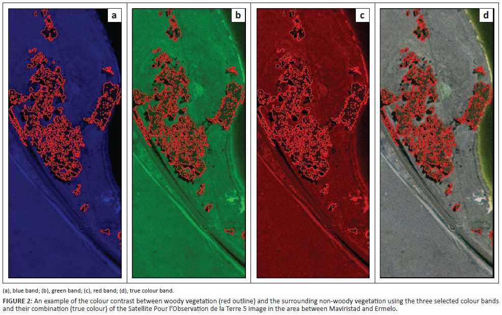
The first step of the mapping phase was to separate the woody vegetation from herbaceous and grass vegetation. This was based on visual interpretation of the SPOT 5 satellite imagery and manual digitising of the background woody vegetation boundary in ArcMap 10.3.1 (ArcGIS ESRI 2015) along a 200 m buffer of railway line. Visual interpretation was made easier because of the sharp colour and texture contrast between woody vegetation and the surrounding area when a satellite image is displayed using true colour bands or a combination of bands (see Figure 2). Although manual digitising has the potential to produce accurate data, it remains error prone and some of the errors common in this study were related to the subjective interpretation and small island polygons. While care was taken when interpreting a satellite image, the process itself is subjective and the accuracy is based on the interpreter's knowledge and experience. Island polygons are those with external borders and one or more internal islands (Gong & Li 2000) and these are often not desired in the output map. While large islands can be easily masked out when digitising, it remains a challenge for small island polygons because digitising is scale dependent. All these errors may be negligible when working on a large area, but they tend to increase the chance of overestimation and underestimation of the infested area when working on small study areas like railway corridors.
To solve the problems of island polygons and subjectivity in the output map associated with manual digitising, the unsupervised classification technique was implemented in ArcMap using the digitised polygons as a mask. Unsupervised classification uses the Iterative Self-Organising Data Analysis technique clustering algorithm that aggregates unknown pixels in an image, based on their natural groupings (Lillesand, Kiefer & Chipman 2008). It is one of the oldest methods of feature extraction from satellite imagery that has been used effectively for mapping vegetation across the globe (e.g. Anchang, Ananga & Pu 2016; Peerbhay, Mutanga & Ismail 2015). The use of unsupervised classification enables the exclusion of island polygons and eliminates subjectivity in the interpretation and outlining of the vegetation boundary in the output spectral classes.
Species identification
A rapid reconnaissance survey along the service road running parallel to the railway lines in our study area was carried out from November 2015 to February 2016 to identify the species occurring in each polygon of the unsupervised thematic maps. Only the species visible from a moving vehicle were recorded within a distance of up to 100 m on either side of the road travelled. A Garmin nüvi Global Positioning System (GPS) was used to record the co-ordinates for each woody vegetation stand or single tree. The co-ordinates were later loaded into the ArcGIS 10.3.1 (ArcGIS ESRI 2015) software for correlation with the unsupervised classification spectral classes. The spatial join technique in ArcGIS 10.3.1 was used to link GPS data with the spectral classes map. Unlike the quadrat inventory method used often in ecology (e.g. Appiah 2013; Houeto et al. 2013; Molano-Flores et al. 2015) which provides a record of species in a grid format (e.g. 25 km × 27 km grid used in SAPIA and PRECIS) (see Richardson et al. 2005), the use of a GPS allowed for the recording of species' location which could be linked to the spectral classes. Sometimes field observation revealed more than one alien plant species in a vegetation cluster. Because of the limitation of SPOT 5 imagery in terms of spectral bands for separation of individual species, it was decided to record all the species present in a cluster during field observations and spatial joining.
Interpretation of the satellite imagery was biased towards woody plant species while grasses, succulents, shrubs and herbaceous plants were difficult to detect. However, field observations revealed some alien grass, succulent, shrub and herbaceous species in the study area. An attempt was made to record their location by estimating the extent of the invaded area in the field and by maximising the use of colour and texture contrast during manual digitising to delineate the invaded area. Field data also revealed the occurrence of indigenous woody species, mainly Diospyros lycioides Desf. and Vachelia karroo (Hayne) Banfi & Galasson, along the Ermelo to Machadodorp railway line. The associated spectral class polygons were subsequently removed from the final alien plant distribution map.
Results
Alien plant distribution
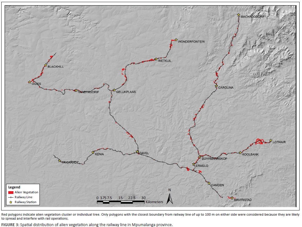
Figure 3 illustrates the spatial distribution of alien plants in the study area. The area with noticeably dense alien vegetation is near Lothair railway station and is characterised by commercial plantations of the Pinus patula Schltdl. & Cham. and Eucalyptus spp., which are spreading rapidly along the railway corridor. Other sections of the railway line with dense alien vegetation include the Ermelo to Machadodorp route, Gelukplaas to Wonderfontein and Ogies to Blackhill. These are areas where Eucalyptus spp. and Acacia spp. dominate. Although the main purpose of this study was to map mainly woody plants, field observation revealed the occurrence of two herbaceous (Argemone mexicana L. and Verbena bonariensis L.), two succulent (Agave sisalana Perrine and Opuntia ficus-indica (L.) Mill.), two shrub (Solanum mauritianum Scop. and Rubus spp.) and one grass (Arundo donax L.) species, which were subsequently added to the spatial distribution map.
Species identified and area extent
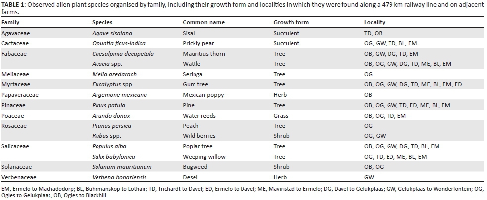
The species observed belong to 12 different families (Table 1). The widespread invaders prevalent in more than four of the railway networks are the Myrtaceae (Eucalyptus spp.), Fabaceae (Acacia spp. and Caesalpinia decapetala (Roth) Alston), Pinaceae (Pi. patula), Salicaceae (Salix babylonica L. and Populus alba) and Cactaceae (O. ficus-indica).
It was difficult to quantify precisely the area invaded by each individual species from the satellite images because some polygons have more than one woody species and SPOT 5 spectral bands cannot be used to separate individual species. However, Table 2 shows that of major concern among the widespread invaders are the Eucalyptus and Acacia species, which affect a combined area of more than 1300 ha and have the highest occurrence or number of individual polygons. Populus alba and Pi. patula affect 10 and 9 ha, respectively, while the areal extent of Sa. babylonica and C. decapetala is negligible (3.1 and 1.4 ha, respectively). In the case of the latter two species, they are represented in a large number of polygons, but this is as isolated individuals or in a few stands.
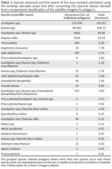
Other species are not prominent and only occur in isolated stands of trees, or they are succulents, shrubs and herbaceous plants. Table 1 provides details of the sections of the railway along which Ag. sisalana, Aru. donax, So. mauritianum, Melia azedarach L., Prunus persica (L.) Batsch, Arg. mexicana, V. bonariensis and Rubus spp. were observed.
Discussion
Identified species
The most dominant alien plant species in terms of the number of times they were observed are the Eucalyptus spp., Acacia spp., C. decapetala, Pi. patula, Sa. babylonica and Po. alba. Eucalyptus spp., Acacia spp. and Pi. patula are the most extensively planted exotic plants for wood and timber in the whole of the southern hemisphere including South Africa (Wingfield et al. 2002). However, since their introduction, some have escaped from cultivation and spread into other areas where they compete with indigenous vegetation. The Salicaceae family which includes Po. alba and Sa. babylonica are rapid-growing deciduous trees that largely occur along watercourses and marshy areas and are associated with reduction in stream flow (Henderson 1991). All the species considered to be dominant have been classified as major invaders previously by Nel et al. (2004), including C. decapetala which falls in category 1 of the Conservation of Agricultural Resources Act (CARA) No. 43 of 1983 regulation (Department of Agriculture 2001), which means that the species must be controlled under all circumstances. Eucalyptus spp., Acacia spp., Pi. patula, Sa. babylonica and Po. alba fall into category 2 of the CARA regulation (Department of Agriculture 2001), which means that because of their commercial value they may be planted in demarcated areas subject to a permit that requires that steps are taken to control their spread to adjacent areas. Other species may not be regarded as dominant in this study, but they raise concerns. Nel et al. (2004) categorised M. azedarach, V. bonariensis, O. ficus-indica, So. mauritianum and Aru. donax as major invaders because they are well established and are already causing substantial impacts on the natural and semi-natural ecosystems. All these species except V. bonariensis appear on the list of species prioritised and ranked by Robertson et al. (2003) based on their potential invasiveness, spatial characteristics, potential impact and potential for control. Additionally, all the species recorded except Sa. babylonica and Pr. persica have been listed in various categories of the most recent alien and invasive species regulations (Department of Environmental Affairs 2014a) of the National Environmental Management: Biodiversity Act (NEM:BA), 2004 (Act No. 10 of 2004) (Department of Environmental Affairs 2014b). This includes category 1b species such as Arg. mexicana, Aru. donax, C. decapetala, M. azedarach, O. ficus-indica, Rubus spp., So. mauritianum and V. bonariensis, which the NEM:BA regulations require be controlled. Eucalyptus spp. are also categorised as 1b if they are in a listed ecosystem. Other species such as Pi. patula and Po. alba are category 2 species, which requires that a permit is obtained by the landowner and that the spread of these species from that land is prevented. It is therefore proposed that these species should be prioritised when planning local scale management.
Limitations of the satellite image
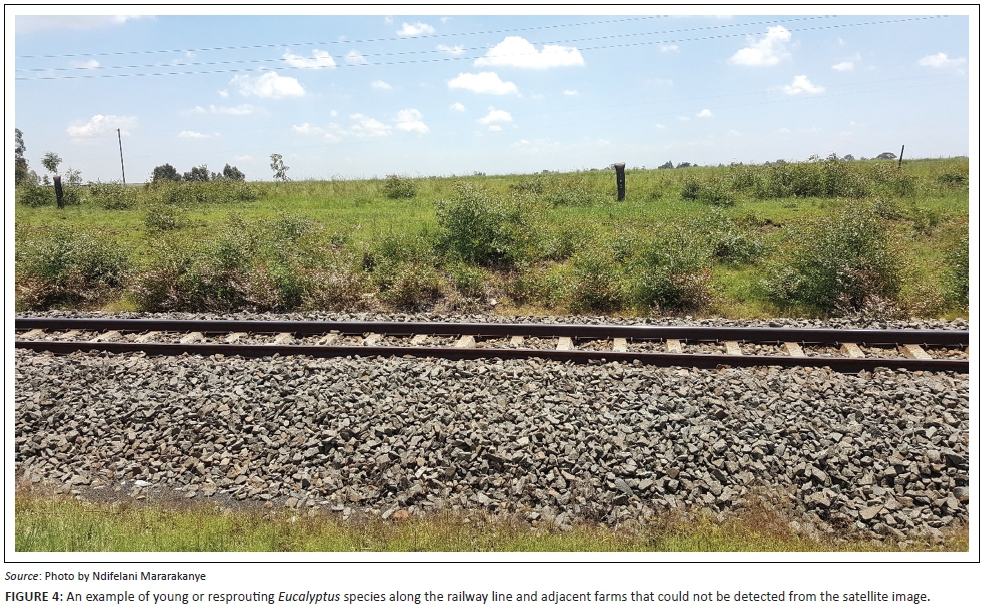
The spatial distribution map is limited to large trees because of the limitation of spectral bands and spatial resolution of SPOT 5 satellite imagery to detect smaller trees. Field observations revealed the occurrence of young trees in other parts of the study area. These young trees, mainly Eucalyptus species blend with the surrounding grassland area, which makes them difficult to separate by visual image interpretation and unsupervised classification, given the limited spectral bands and spatial resolution. Interpretation was also made difficult because the plants may have been too young or non-existent when the satellite image was taken. Figure 4 illustrates the example of young or resprouting Eucalyptus spp. in the study area, which could not be detected from a satellite image. It was observed that young Eucalyptus spp. are spreading rapidly to and from the neighbouring agricultural lands. Generally, Eucalyptus spp. are recognised as one of the fastest growing trees that may reach up to 6 m in 4 years (Bennett 2011). It is therefore important to control the spread of these young plants before they reach maturity and the costs of control increase substantially.
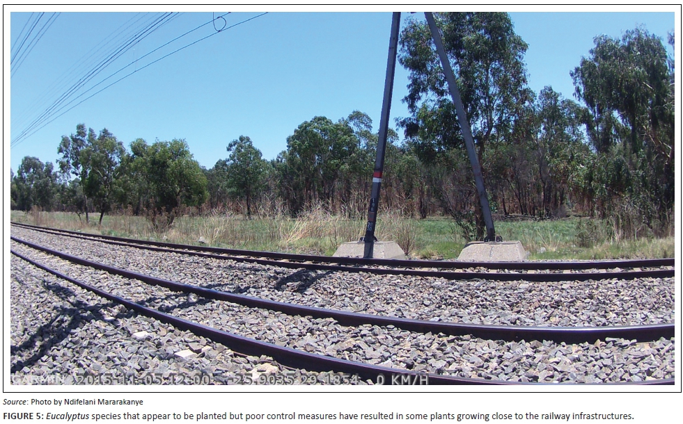
Some of the land parcels next to the railway line have been planted with Eucalyptus spp. and Pi. patula for commercial purposes and this appears to be the initiation point for potential spread (see Figure 5). Once they spread into the railway corridor, they spread further into other areas if not controlled. Richardson (1998) claimed that invasion from commercial plantations is a bigger problem than from other forms of introduction because in plantations, species occur in greater numbers over a large area. However, not all alien plant species along the railway corridor in this study can be associated with commercial plantations. Railway development itself is a disturbance of the environment and has the potential for increasing dissemination of propagules, which makes the ecosystems more susceptible to invasion by alien species (Richardson & Van Wilgen 2004). The disturbed area is particularly important during the early stage of invasion because it creates vacant niches that alien plants can colonise (Masters & Sheley 2001). Rutkovska et al. (2013) found that some of the alien taxa in Latvia were associated with topsoil disturbance because of the construction and maintenance of railway lines. It is therefore possible that the development of railway networks in the study area may have promoted the distribution and spread of some of the alien plants.
Comparison with other studies
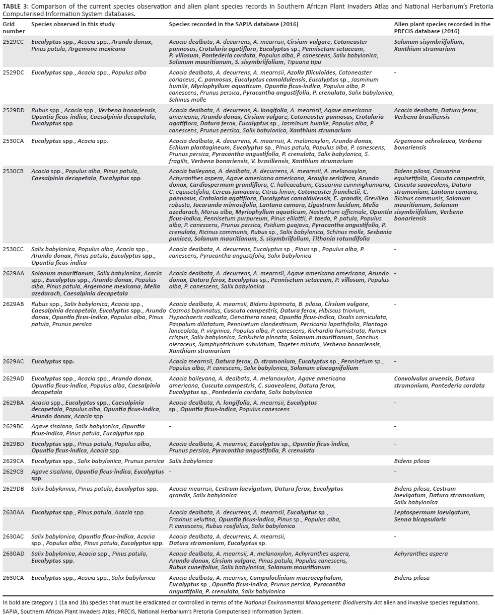
Our study was not intended to provide a complete list of alien plant species occurring in the area and we did not record all species identified in other databases. This is mainly because the current inventory was only obtained along the railway line and adjacent farms, whereas other studies have included observations in environments such as watercourses, grassland, savannah and human-modified habitats (e.g. Henderson 2007). For easier comparison with other comprehensive databases on alien plants such as SAPIA and PRECIS, alien species were summarised per quarter degree grid as shown in Table 3.
The current study and SAPIA have more similar species recorded per quarter grid than the PRECIS database. The most prominent species in the current study list and SAPIA database include the Acacia spp., Eucalyptus spp., Sa. babylonica, So. mauritianum, Po. alba, O. ficus-indica, Agave spp., Pi. patula, Aru. donax and Rubus spp. (Henderson 1999). For years, SAPIA has been the most important data source on the distribution of alien plant species; thus, a good correlation with SAPIA would suggest that the current study could also be used when planning for implementation of control measures in Mpumalanga province. The reason there is more similarity in species observed is probably because the SAPIA database also includes observations made along railway lines in grids 2529CC, 2529DC, 2530CA, 2629AA, 2629AB, 2629AC, 2629AD, 2629DB and 2630CA. There are other species listed by SAPIA as occurring along railway lines in our study site that were not observed in the current study and these include herbaceous (Campuloclinium macrocephalum (Less.) DC., Datura ferox L., Cuscuta campestris Yunck., Cuscuta suaveolens Ser., Solanum elaeagnifolium Cav. and Cirsium vulgare (Savi) Ten.), shrub (Pyracantha angustifolia (Franch.) C.K.Schneid., Pyracantha crenulata (D.Don) M.Roem.) and grass (Pennisetum setaceum (Forssk.) Chiov., Pennisetum villosum R.Br. ex Fresen.) species. The reason these species were not observed in the current study could be that they are not widespread or they may have been temporarily or permanently cleared during railroad maintenance work. Some species may also have been dormant at the time the field survey was undertaken.
The inventory of alien plants in this study is notably different to the list from the PRECIS database. This is probably because PRECIS has limited data for alien species, and it has a bias towards herbaceous and shrub species, whereas this study primarily focused on woody plants. Similar species were only observed in grid 2529DD (Acacia spp. and V. bonariensis) and 2629DB (Sa. babylonica). The differences justify the importance of carrying out a field study at the local level for planning and implementation of control measures. Both SAPIA and PRECIS are useful at the national level when planning and prioritising species and areas for management action (see Nel et al. 2004), whereas the current study will facilitate the implementation of control measures at the local scale.
Conclusion
By combining the maps from remote sensing with field observations, it helped to improve our knowledge of alien plant species' distribution and the extent of the invaded area along the railway line in the Mpumalanga province. This approach can be used in other regions where woody plants dominate. This study found that just like many other disturbed environments which include roadsides, plantations, heavily grazed and cultivated lands, railway lines are invaded by a variety of alien plant species in the Mpumalanga province. The biggest threat is posed by Eucalyptus spp., Acacia spp., C. decapetala, Pi. patula, Sa. babylonica and Po. alba because they cover the most surface area around the railway lines and are represented in a noteworthy number of individual polygons. Other species such as M. azedarach, V. bonariensis, O. ficus-indica, So. mauritianum and Aru. donax may not necessarily be dominant in this study, but they need to be prioritised for control purposes because they have been identified elsewhere (e.g. Nel et al. 2004; Robertson et al. 2003) as major invaders that are well established and are already causing substantial impacts on the natural and semi-natural ecosystems. They may also pose a threat to biodiversity and railway management in future in the study area if their population is not properly managed.
This study should be regarded as a first step towards understanding alien plant invasion along the railway line in Mpumalanga province. While the current study only focused on the mapping and identification of species, future studies should look into the role of railway lines in dispersal of alien plants. It is well understood that commercial forestry and other means of introduction are the primary sources of alien plants in South Africa, but railway lines may have played a role as driver pathway for spread of alien plants from one locality to the other because not all invaded areas have a history of commercial forestry (Nyoka 2003). The spatial distribution map of alien plant species will be useful for effective planning, management and monitoring of the spatial changes of the infestation.
Acknowledgements
The authors would like to thank the Department of Agriculture, Rural Development, Land and Environmental Affairs for the provision of software, data and imagery used in this study. This article benefited from comments by two anonymous reviewers and those of the editor, Dr Michelle Hamer.
The authors would also like to thank DEA - Working for Water Programme for their willingness to facilitate and fund the clearing of alien plants in the study area.
Competing interests
The authors declare that they have no financial or personal relationship(s) that may have inappropriately influenced them in writing this article.
Authors' contributions
N.M. was the project leader and was responsible for drafting the manuscript as well as geospatial interpretation. M.N.M., M.C.R., N.N.M. and S.R.N. were responsible for both field data collection and revising the scope and content of the draft manuscript.
References
Anchang, J.Y., Ananga, E.O. & Pu, R., 2016, 'An efficient unsupervised index based approach for mapping urban vegetation from IKONOS imagery', International Journal of Applied Earth Observation and Geoinformation 50, 211-220. https://doi.org/10.1016/j.jag.2016.04.001 [ Links ]
Appiah, M., 2013, 'Tree population inventory, diversity and degradation analysis of a tropical dry deciduous forest in Afram Plains, Ghana', Forest Ecology and Management 295, 145-154. https://doi.org/10.1016/j.foreco.2013.01.023 [ Links ]
ArcGIS ESRI version 10.3.1, 2015, computer software, Environmental Systems Research Institute, Inc., Redlands, CA. [ Links ]
Barbosa, N.P.U., Fernandes, G.W., Carneiro, M.A.A. & Júnior, L.A.C., 2010, 'Distribution of non-native invasive species and soil properties in proximity to paved roads and unpaved roads in a quartzitic mountainous grassland of Southeastern Brazil (rupestrian fields)', Biological Invasions 12(11), 3745-3755. https://doi.org/10.1007/s10530-010-9767-y [ Links ]
Bennett, B.M., 2011, 'Naturalising Australian trees in South Africa: Climate, exotics and experimentation', Journal of Southern African Studies 37(2), 265-280. https://doi.org/10.1080/03057070.2011.579434 [ Links ]
Christen, D. & Matlack, G., 2006, 'The role of roadsides in plant invasions: A demographic approach', Conservation Biology 20(2), 385-391. https://doi.org/10.1111/j.1523-1739.2006.00315.x [ Links ]
Crimmins, T.M., Mauzy, M.S. & Studd, S.E, 2008, 'Assessing exotic plant distribution, abundance, and impact at Montezuma Castle and Tuzigoot National Monuments in Arizona', Ecological Restoration 26(1), 44-50. https://doi.org/10.3368/er.26.1.44 [ Links ]
Dar, P.A., Reshi, Z.A. & Shah, M.A, 2015, 'Roads act as corridors for the spread of alien plant species in the mountainous regions: A case study of Kashmir Valley, India', Tropical Ecology 56(2), 183-190. [ Links ]
Department of Agriculture, 2001, Conservation of Agricultural Resources Act (CARA) 43 of 1983, Government Notice R280, Government Gazette 22166, amended 2001, viewed 06 June 2016, from http://www.nda.agric.za/ [ Links ]
Department of Environmental Affairs, 2014a, National Environmental Management: Biodiversity Act (NEMBA) (10/2004): Alien and Invasive Species Regulations, Government Notice R598, Government Gazette 37885, viewed 10 September 2016, from http://www.gpwonline.co.za [ Links ]
Department of Environmental Affairs, 2014b, National Environmental Management: Biodiversity Act (NEMBA) (10/2004): Alien and Invasive Species List, Government Notice R599, Government Gazette 37886, viewed 10 September 2016, from http://www.gpwonline.co.za [ Links ]
Ferrar, A.A. & Lotter, M.C., 2007, Mpumalanga biodiversity conservation plan handbook, The Mpumalanga Tourism and Parks Agency, Nelspruit. [ Links ]
Geological Survey, 1986a, 2528 Pretoria, 1:250 000 Geological Series, Department of Mineral and Energy Affairs, Pretoria. [ Links ]
Geological Survey, 1986b, 2530 Nelspruit, 1:250 000 Geological Series, Department of Mineral and Energy Affairs, Pretoria. [ Links ]
Geological Survey, 1986c, 2628 East Rand, 1:250 000 Geological Series, Department of Mineral and Energy Affairs, Pretoria. [ Links ]
Geological Survey, 1986d, 2630 Mbabane, 1:250 000 Geological Series, Department of Mineral and Energy Affairs, Pretoria. [ Links ]
Gong, J. & Li, D., 2000, 'Object-oriented and integrated spatial data model for managing image, DEM, and vector data', Photogrammetric Engineering & Remote Sensing 66(5), 619-623. [ Links ]
Henderson, L., 1991, 'Alien invasive Salix spp. (willows) in the grassland biome of South Africa', South African Forestry Journal 157(1), 91-95. https://doi.org/10.1080/00382167.1991.9629105 [ Links ]
Henderson, L., 1999, 'The Southern African Plant Invaders Atlas (SAPIA) and its contribution to biological weed control', African Entomology Memoir 1, 159-163. [ Links ]
Henderson, L., 2007, 'Invasive, naturalized and casual alien plants in southern Africa: A summary based on the Southern African Plant Invaders Atlas (SAPIA)', Bothalia 37(2), 215-248. https://doi.org/10.4102/abc.v37i2.322 [ Links ]
Houeto, G., Kakai, G.R., Salako, V., Fandohan, B., Assogbadjo, A.E., Sinsin, B. et al., 2013, 'Effect of inventory plot patterns in the floristic analysis of tropical woodland and dense forest', African Journal of Ecology 52(3), 257-264. https://doi.org/10.1111/aje.12112 [ Links ]
Jeffrey, L.S., 2005, 'Characterization of the coal resources of South Africa', The Journal of the South African Institute of Mining and Metallurgy 105(2), 95-102. [ Links ]
Johnson, M.R., 1976, 'Stratigraphy and sedimentology of the Cape and Karoo sequences in the Eastern Cape province', PhD thesis, Dept. of Geology, Rhodes University. [ Links ]
Kotzé, I., Beukes, H., Van den Berg, E. & Newby, T., 2010, National invasive alien plant survey. Agricultural Research Council, Institute for Soil, Climate and Water, Pretoria. Report No. GW/A/2010/21, viewed 27 March 2017, from http://sites.google.com/site/wfwplanning/assessment [ Links ]
Land Types of South Africa and Soil Inventory Databases [computer file], 1984, ARC-Institute for Soil, Climate and Water, Pretoria, viewed 18 May 2016, from the Department of Agriculture, Rural Development, Land and Environmental Affairs, GIS_SERVER\Data\Vector.gdb\landtype_polygon\. [ Links ]
Le Maitre, D.C., Versfeld, D.B. & Chapman, R.A., 2000, 'The impact of invading alien plants on surface water resources in South Africa : A preliminary assessment', Water SA 26(3), 397-408. [ Links ]
Lillesand, T.M., Kiefer, R.W. & Chipman, J.W., 2008, Remote sensing and image interpretation, 6th edn., John Wiley & Sons Ltd, Hoboken, NJ. [ Links ]
Masters, R.A. & Sheley, R., 2001, 'Invited synthesis paper : Principles and practices for managing rangeland invasive plants', Journal of Range Management 54(5), 502-517. https://doi.org/10.2307/4003579 [ Links ]
Masubelele, M.L., Foxcroft, L.C. & Milton, S.J., 2009, 'Alien plant species list and distribution for Camdeboo National Park, Eastern Cape province, South Africa', Koedoe 51(1), Art. #515, 1-10. https://doi.org/10.4102/koedoe.v51i1.515 [ Links ]
Milton, S.J. & Dean, W.R.T., 1998, 'Alien plant assemblages near roads in arid and semi-arid South Africa', Diversity and Distributions 4(4), 175-187. https://doi.org/10.1046/j.1472-4642.1998.00024.x [ Links ]
Molano-Flores, B., Phillippe, L.R., Marcum, P.B., Carroll-Cunningham, C., Ellis, J.L., Busemeyer, D.T. et al., 2015, 'A floristic inventory and vegetation survey of three dolomite prairies in northeastern Illinois', Castanea 80(3), 153-170. https://doi.org/10.2179/14-040 [ Links ]
Mucina, L. & Rutherford, M.C. (eds.), 2006, The vegetation of South Africa, Lesotho and Swaziland, Strelitzia 19, South African National Biodiversity Institute, Pretoria. [ Links ]
National Herbarium Pretoria Computerised Information System (PRECIS) database, 2016, Plants of southern Africa: An online checklist, viewed 06 June 2016, from http://posa.sanbi.org [ Links ]
Nel, J.L., Richardson, D.M., Rouget, M., Mgidi, T.N., Mdzeke, N., Le Maitre, D.C. et al., 2004, 'A proposed classification of invasive alien plant species in South Africa: Towards prioritizing species and areas for management action', South African Journal of Science 100(1), 53-64. [ Links ]
Nyoka, B.I., 2003, Biosecurity in forestry: A case study on the status of invasive forest trees species in Southern Africa, Forest Biosecurity Working Paper FBS/1E, FAO, Rome, viewed 03 March 2017, from http://www.fao.org/docrep/005/ac846e/ac846e00.htm#Contents [ Links ]
Peerbhay, K.Y., Mutanga, O. & Ismail, R., 2015, 'Random forests unsupervised classification: The detection and mapping of solanum mauritianum infestations in plantation forestry using hyperspectral data', IEEE Journal of Selected Topics in Applied Earth Observations and Remote Sensing 8(6), 3107-3122. https://doi.org/10.1109/JSTARS.2015.2396577 [ Links ]
Pysek, P., Danihelka, J., Sádlo, J., Chrtek, J., Chytrý, M., Jarošík, V. et al., 2012, 'Catalogue of alien plants of the Czech Republic (2nd edition): Checklist update, taxonomic diversity and invasion patterns', Preslia 84(2), 155-255. [ Links ]
Richardson, D.M., 1998, 'Forestry trees as invasive aliens', Conservation Biology 12(1), 18-26. https://doi.org/10.1046/j.1523-1739.1998.96392.x [ Links ]
Richardson, D.M., Pysek, P., Rejmanek, M., Barbour, M.G., Dane Panetta, F. & West, C.J., 2000, 'Naturalization and invasion of alien plants : Concepts and definitions', Diversity and Distributions 6(2), 93-107. https://doi.org/10.1046/j.1523-1739.1998.96392.x [ Links ]
Richardson, D.M., Rouget, M., Ralston, S.J., Cowling, R.M., Van Rensburg, B.J. & Thuiller, W., 2005, 'Species richness of alien plants in South Africa: Environmental correlates and the relationship with indigenous plant species richness', Ecoscience 12(3), 391-402. https://doi.org/10.2980/i1195-6860-12-3-391.1 [ Links ]
Richardson, D.M. & Van Wilgen, B.W., 2004, 'Working for Water: Invasive alien plants in South Africa: How well do we understand the ecological impacts?', South African Journal of Science 100(1), 45-52. [ Links ]
Robertson, M.P., Villet, M.H., Fairbaks, D.H.K., Henderson, L., Higgins, S.I., Hoffmann, J.H. et al., 2003, 'A proposed prioritization system for the management of invasive alien plants in South Africa', South African Journal of Science 99, 37-43. [ Links ]
Rutkovska, S., Pučka, I., Evarts-Bunders, P. & Paidere, J., 2013, 'The role of railway lines in the distribution of alien plant species in the territory of Daugavpils City (Latvia)', Estonian Journal of Ecology 62(3), 212-225. https://doi.org/10.3176/eco.2013.3.03 [ Links ]
Southern African Plant Invaders Atlas (SAPIA) database, 2016, Plant Protection Research Institute, Agricultural Research Council, viewed 06 June 2016, from http://www.agis.agric.za/agisweb/agis.html [ Links ]
Turner, D.P., 2000, 'Soils of KwaZulu-Natal and Mpumalanga: Recognition of natural soil bodies', PhD thesis, Dept. of Plant Production and Soil Science, University of Pretoria. [ Links ]
Van Wilgen, B.W., Richardson, D.M., Le Maitre, D.C., Marais, C. & Magadlela, D., 2001, 'The economic consequences of alien plant invasions: Examples of impacts and approaches to sustainable management in South Africa', Environment, Development and Sustainability 3(2), 145-168. https://doi.org/10.1023/A:1011668417953 [ Links ]
Wells, M.J., Balsinhas, A.A., Joffe, H., Engelbrecht, V.M., Harding, G. & Stirton, C.H., 1986, A catalogue of problem plants in southern Africa: Incorporating the national weed list of southern Africa, Memoirs of the Botanical Survey of South Africa, No. 53, Botanical Research Institute, Pretoria. [ Links ]
Williams, V.L. & Crouch, N.R., 2017, 'Locating sufficient plant distribution data for accurate estimation of geographic range: The relative value of herbaria and other sources', South African Journal of Botany 109, 116-127. https://doi.org/10.1016/j.sajb.2016.12.015 [ Links ]
Wingfield, M.J., Coutinho, T.A., Roux, J. & Wingfield, B.D., 2002, 'The future of exotic plantation forestry in the tropics and southern Hemisphere: Lessons from pitch canker', Southern African Forestry Journal 195, 79-82. https://doi.org/10.1080/20702620.2002.10434607 [ Links ]
 Correspondence:
Ndifelani Mararakanye
nmararak@gmail.com
Received: 13 July 2016
Accepted: 13 Mar. 2017
Published: 19 May 2017

