


Services on Demand
Article
 English (pdf)
 Article in xml format
 Article references
Indicators

Related links
-
 Cited by Google
 -
 Similars in Google
Share

 Permalink
Bothalia - African Biodiversity & Conservation
On-line version ISSN 2311-9284
Print version ISSN 0006-8241
Bothalia (Online) vol.46 n.2 Pretoria 2016
http://dx.doi.org/10.4102/abc.v46i2.2148
ORIGINAL RESEARCH
A spatial and temporal assessment of fire regimes on different vegetation types using MODIS burnt area products
Nokuphila L.P. ButheleziI; Onisimo MutangaI; Mathieu RougetII; Mbulisi SibandaI
IDepartment of Geography and Environmental Science, School of Agricultural, Earth and Environmental Sciences, University of KwaZulu-Natal, South Africa
IICentre for Invasion Biology, School of Agriculture, Earth and Environmental Sciences, University of KwaZulu-Natal, South Africa
ABSTRACT
BACKGROUND: The role of fire in maintaining grassland diversity has been widely recognised; however, its effect in KwaZulu-Natal grasslands is still rudimentary. In that regard, understanding fire regimes of different vegetation types in KwaZulu-Natal is a critical step towards the development of effective management strategies that are specific to each vegetation type.
OBJECTIVE: To assess the effect of different vegetation types on fire regimes in KwaZulu-Natal using moderate resolution imaging spectroradiometer (MODIS) burnt fire products.
METHOD: Ten years of fire data for four different vegetation types (Ngongoni Veld, KwaZulu-Natal Sandstone Sourveld, Eastern Valley Bushveld and KwaZulu-Natal Coastal Belt) were extracted from the MODIS products and used as a basis to establish three parameters: annual burnt areas, fire season and fire frequency. The total burnt area within each vegetation type over the 10-year period was quantified.
RESULTS: The KZN Sandstone Sourveld had a high-burnt area of 80% in 2009 with KwaZulu-Natal Coastal Belt having the least burnt area of less than 5%. Ngongoni Veld and the KwaZulu-Natal Sandstone Sourveld had the highest fire frequency, while the coastal region had low fire frequencies. Results showed high fire prevalence during the late period of the dry season (which extends from June to August) across all the vegetation types.
CONCLUSION: This study underscores the potential of remotely sensed data (MODIS burned area products) in providing a comprehensive view of fire patterns in different vegetation types.
Introduction
Understanding and characterising the spatial and temporal fire regimes is essential for improving our knowledge on vegetation species composition (Hardtke et al. 2015; Uys, Bond & Everson 2004). Fire is both a naturally occurring and human-induced phenomenon that may be beneficial or catastrophic to the ecosystem and human lives (Baudena et al. 2015; Devineau, Fournier & Nignan 2010). While fire is deemed to be a necessary occurrence for the health and diversity of some ecosystems, on the contrary, it may cause complete destruction of some ecosystems (Bucini & Lambin 2002). Fires that occur over lengthy time periods have collectively been identified as fire regimes and are defined by factors such as frequency, severity, intensity, spatial pattern and seasonality (Gill 1975). Human activities have altered the natural fire regimes through increased fire ignitions and fire suppression (Bond & Parr 2010; Bond & Zaloumis 2016). Furthermore, altered fire regimes in turn impact negatively on the ecosystem by promoting the dominance of alien invasive species and compromising natural resources (Hardtke et al. 2015). Fires also have wide-ranging implications for carbon dynamics and air quality (Bucini & Lambin 2002). Socio-economic impacts of altered fire regimes may comprise increased fire frequencies, which directly leads to more damage to property, infrastructure and livestock losses, increased risk of soil erosion and risk of run-off and in extreme cases loss of human life (Barbosa et al. 1999; Uys et al. 2004). Consequently, there is a need to quantify fire patterns especially in areas of biological significance. Therefore, mapping and monitoring fires can assist in the implementation of effective management strategies and equip land managers with the necessary information for regulatory requirements (Chu & Guo 2015; De Araújo & Ferreira 2015).
Traditionally, fire information on grasslands and savannah ecosystems was obtained through techniques that were tedious, time consuming and expensive, such as field surveys that are laborious and hand-drawn fire maps (Mitri & Gitas 2013; Tian et al. 2005). Technological advances in remote sensing over the years have increased the ability to suit the unique applications needed for fire management (Chu & Guo 2015; Pereira 2003; Zhan et al. 2002). Remote sensing provides cheap, consistent and unbiased observations of fire activity by providing essential information such as the size, timing, location and spatial extent of the fire (Archibald & Roy 2009; Laris 2005). Various studies have successfully utilised remote sensing in mapping and quantifying fire regimes in different regions using different earth observation sensors, that is, moderate resolution imaging spectroradiometer (MODIS), Landsat and spot (Boschetti et al. 2015). For example, in South Africa, Hudak, Fairbanks & Brockett (2004) used Landsat TM imagery supervised classification to map burnt areas in the savannah biome. Archibald et al. (2010) used the MODIS sensor to produce a visual interpretation of fire regimes in Southern Africa. In a more recent study, Goodwin et al. (2013) used a time series of Landsat TM/ETM+ imagery to quantify fire activities in the state of Queensland, Australia. These studies demonstrate the utility of satellite remotely sensed data in mapping burnt areas.
The aforementioned sensors use two direct fire detection methods to achieve burnt area mapping over large areas. The fire detection methods used in remote sensing are (i) active fire detection, which detects thermal anomalies, and (ii) mapping of burnt areas, which concentrates on the impacts fire has on the vegetation (Bucini & Lambin 2002; Roy & Boschetti 2009; Tsela at al. 2014). The burnt areas are often characterised by ash, bare ground and other physical changes in vegetation (Boschetti et al. 2015; Roy et al. 2008). It is the detection of these physical and spectral changes in vegetation that permits burnt area mapping over time and space (De Araújo & Ferreira 2015; Roy et al. 2008).
Sensors that have been extensively utilised in mapping burnt areas are Advanced Very High Resolution Radiometer (AVHRR), Landsat and recently MODIS (Pereira 2003; Mitri & Gitas 2013). The use of these sensors largely depends on the scale at which fires are to be mapped. For instance, AVHRR is characterised by a spatial resolution of 1000 m and a daily temporal resolution, which has proven to be the most efficient and practical means of fire mapping at a regional scale (Chu & Guo 2015; Mitri & Gitas 2013). However, the low thermal sensitivity and low spatial resolution of the sensor inhibits the accurate detection of fires that are less than its pixel size, thus underestimating the burnt area (Mitri & Gitas 2013; Pereira 2003). Subsequently, MODIS overcame the flaws associated with AVHRR by providing a trade-off between fire mapping over time and space (Martín et al. 2002). Furthermore, the temporal resolution of MODIS makes it a better source of burnt area data when compared to other sensors such as Landsat with a 16-day temporal resolution (Tsela et al. 2014). MODIS also allows for a long time series of burnt area mapping, courtesy of its high temporal resolution compared to other sensors listed above.
Although the earliest remote sensing methods failed to distinguish burnt areas from areas exhibiting similar spectral reflectance such as croplands (Csiszar et al. 2003), recent studies have utilised MODIS burnt area and active fire method simultaneously to determine the burnt areas. For instance, Devineau et al. (2010) used MODIS active fire data in conjunction with burnt area data and noted that small fragmented fires were better detected by active data, while burnt data revealed the large continuous flames that were not detected by the active data. However, the above studies did not compare the inter-annual variability and fire distribution patterns over different vegetation types, which is a critical step in biodiversity management.
Inter-annual variability in fire incidence and burnt area vary between vegetation types (Laris 2005; Uys et al. 2004). The disparities of fire occurrence among vegetation are influenced by numerous physical, biological and cultural factors that include fuel properties, plant structure, micro-climate and topography (Baudena et al. 2015; De Araújo & Ferreira 2015). These variations trigger different responses between and within plant species. For instance, grasslands that are characterised by fine dry fuels will experience more frequent fires than deciduous vegetation with a high moisture content (Barbosa et al. 1999; Govender, Trollope & Van Wilgen 2006; Uys et al. 2004). Therefore, it is essential to understand how these parameters vary across different vegetation types, as this will inform area-specific fire management and inform policy makers.
KwaZulu-Natal (KZN) is an area with high summer rainfall and long dry winter periods. Anthropogenic drivers such as intense fires, grazing and urbanisation lead to degradation and transformation of grasslands in KwaZulu-Natal. For example, human activities have been the main driver resulting in the current endangered threat status of the KZN Sandstone Sourveld (Mucina et al. 2005). Despite the small portion under conservation management, knowledge about the fire regimes in KZN vegetation types is still rudimentary. Inappropriate fire regimes may threaten the existence of endemic species in the different vegetation types, particularly in the drier regions that are more prone to fire (Archibald & Roy 2009). In that regard, it is important to map and understand the historical fire regimes in the different vegetation types to achieve proper management strategies specific to a certain vegetation type.
In this study, we therefore assess the variations of fire regimes as a function of different vegetation types in KZN using MODIS burned fire products. The objective of this study was to quantify the annual burnt area, fire frequency and fire seasonality in KwaZulu-Natal based on MODIS burnt area products.
Materials and methods
Study area
The study area is located in the Eastern part of the KwaZulu-Natal Province, situated within five municipalities, S29° 58' 4.79", E30° 33' 17.99" The area is characterised by a variety of vegetation types, but for the purpose of this study, emphasis was placed on only four types. These are the Ngongoni Veld, Eastern Valley Bushveld, KZN Coastal Belt and KZN Sandstone Sourveld (Figure 1). These vegetation types were selected because their heterogeneity provides a fire-prone environment that influences fire patterns and behaviour (Bucini & Lambin 2002). The region experiences hot summers and cool dry winter months, which promote the occurrence of fire, at the same time maintaining the integrity of the different vegetation types. The region receives precipitation ranging from 800 to 1200 mm annually. The maximum temperatures in summer may range from 27°C to 32°C, with winter temperatures dropping to between 4.7°C and 15.1°C.
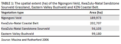
KZN Coastal Belt Grassland occurs at very low elevations (20-450 m) and is dominated by Themeda triandra. It is classified as Endangered (Mucina et al. 2005). Ngongoni Veld is dominant in low elevation areas (400-900 m). This veld is dominated by Aristida junciformis and wooded vegetation in higher altitudes. This vegetation type is also classified as endangered with less than 1% under conservation. KwaZulu-Natal Sandstone Sourveld occurs between 500 and 1100 m. This species-rich grassland is also characterised by Proteaceae and shrubs (Mucina et al. 2005). The grassland is endangered as much of its original extent has been transformed by human activities. The Eastern Valley Bushveld occurs at high elevations, ranging from 100 to 1000 m. Fire tends to be less abundant in this vegetation compared to other areas because species in this vegetation type tend to retain more moisture in their tissues in the dry season making them less susceptible to fire damage (Mucina & Rutherford 2006). Savannah woodlands and succulents flourish in this vegetation community. The vegetation is the least threatened but only 0.8% is formally conserved (Mucina et al. 2005). This is because the Eastern Valley Bushveld occurs in areas less suitable for development and is subjected to slow habitat transformation compared to the other vegetation types.
Fire data derived from satellite imagery
MODIS (MCD45A1) burnt area data sets covering a period of 10 years (2004-2013) were used to map fires in the above-mentioned vegetation types. The MODIS burnt area data sets have a temporal resolution of 8 days and spatial resolution of 500 m covering the period from 1 April 2001 till the present day (Roy et al. 2015). The sensor estimates the exact date of the fire and provides the location of fires (Roy et al. 2015). Furthermore, an accuracy assessment study conducted in Southern Africa showed that MODIS can detect about 75% of the burnt area (Roy & Boschetti 2009). Therefore, the product can successfully be utilised to map burnt areas across local and regional scales.
The Modified Fill Algorithm developed by Archibald and Roy (2009) was used to identify individual fires from the burnt areas. The algorithm uses the Julian dates to group neighbouring pixels that burnt in 8 days/1 km and gives them a unique identity as in Archibald et al. (2010). Polygons that had the same identity were dissolved to form a single individual fire. The algorithm was applied throughout the data set until all the individual fires were identified. Applying the algorithm throughout the 10-year data set permitted the analysis of fire frequency, seasonality and burnt areas in the different vegetation types over the 10-year period.
Annual burnt area
Monthly burnt area data (areas that contained a fire within the period of a month) were merged for each year in order to produce annual burnt area data from 2004 to 2013. The annual burnt area data were overlaid with the vegetation (Ngongoni Veld, Eastern Valley BushVeld, KZN Sandstone Sourveld and KZN Coastal Belt) layers to calculate total annual burnt area per vegetation type over the 10-year period considered in this study. The results were histograms illustrating the distribution of burnt area expressed as a proportion of total area of each vegetation type over the 10-year period.
Fire frequency
The annual burnt area layers from 2004 to 2013 were combined using the raster calculator. The number of times that a pixel burnt from 2004 to 2013 was calculated. Despite the fact that merging created an overlap of the fire polygons for each year, the characteristics and spatial integrity of the original fire were preserved (Wittkuhn & Hamilton 2010). A fire frequency map, expressed as the mean fire return interval in 10 years was produced. The classes ranged from 1 to 2 years; from 2 to 5 years; from 5 to 7 years and from 7 to 10 years.
Fire season
The one-way analysis of variance (ANOVA) test was conducted to evaluate whether there were significant differences in burnt areas across the fire season. In this study, the fires that occurred from January to April and October to December were not included because there were no significant fire activities detected by MODIS during those months (Archibald et al. 2010; Bond, Midgley & Woodward 2003; Bond & Parr 2010; Uys et al. 2004). The length of fire activity (seasonality) and that of high-burnt area months was presented.
Results
Annual burnt area
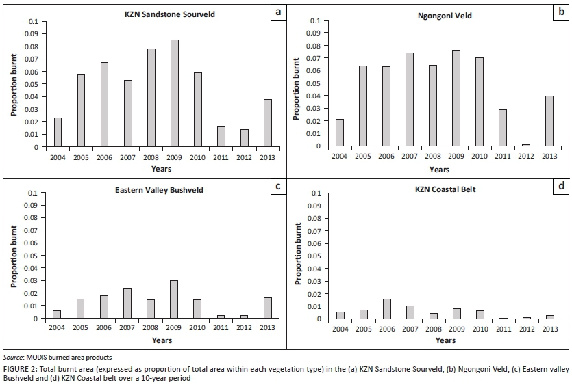
The total burnt area per vegetation type varied considerably across the 10-year period of study. A general increase in burnt area was between 2004 and 2009 after which the burnt areas begin to decrease. Specifically, the highest burnt area was observed in 2009, while the lowest burnt areas were observed in 2004, 2011 and 2012 (Figure 2). The KZN Sandstone Sourveld had the highest total burnt area (80%) in 2009, while the KZN Coastal Belt and Eastern Valley Bushveld had the least burnt area of <5%. The Ngongoni Veld maintained high burnt areas of over 60% from 2005 to 2010 (Figure 2).
Fire frequency
Each type or area of vegetation has been burnt for at least 0-2 years within the 10-year study period (Figure 3). Generally, short fire return intervals of 0-2 years were observed along the northern region of the study area. Short fire return intervals (0-5) were observed in the Eastern Valley Bushveld and the KZN Coastal belt. While the Ngongoni Veld and KwaZulu-Natal Sandstone Sourveld had longer fire return interval ranging from 5 to 10 years, in the extreme eastern and southern parts of the study extent (Figure 3).
Fire seasonality
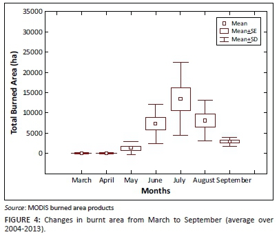
ANOVA testing showed that there were statistically significant (p < 0.05) differences in terms of burnt area over the 7 months from March to September (Figure 4). Low-burnt areas were observed in March, the burnt areas start to increase at the onset of the dry season in May (mean = 3000 ha) reaching the highest burnt areas in July (mean = 13,000 ha) and then decreasing towards the end of the dry season in September (mean = 2872 ha).
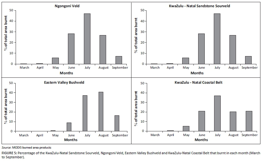
A seasonal pattern was observed in burnt area across different vegetation types. Generally, a high percentage of burnt area was observed between June and August (Figure 5). A relatively low percentage of area was burnt in March and April across all the different vegetation types. Specifically, the highest total burnt area was observed in June across the KwaZulu-Natal Sandstone Sourveld, Ngongoni Veld and KwaZulu-Natal Coastal Belt. The exception is the Eastern Valley Bushveld, where the majority of fires burnt in August (< 40%).
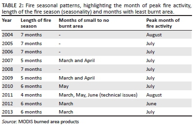
A summary of fire seasonality from 2004 to 2013 is illustrated in Table 1. It was observed that the fire season for most of the years lasted for up to 7 months with years 2005 (4 months) and 2009 (5 months) having shorter fire seasons. March and April are the 2 months with the least burnt area, while July and August had the highest burnt area (Table 2).
Discussion
This study sought to assess the variations of fire regimes as a function of different vegetation types in KZN using MODIS burnt fire products. The objective of this study was to quantify the annual burnt area, fire frequency and fire seasonality in KwaZulu-Natal based on MODIS burnt area products.
The results of this study showed a general increase in burnt area that was observed between 2004 and 2009, after which the burnt areas began to decrease. This trend can be explained by years of high precipitation resulting in high moisture content in 2004 and 2005, followed by warm dry periods (2006 and 2009) characterised by high combustion fires (Archibald et al. 2010; Laris 2005).
There was a high variability in total area burnt across the different vegetation types. Specifically, the KwaZulu-Natal Sandstone Sourveld and Ngongoni Veld incurred the highest burnt area and a high frequency of evenly distributed fires across space, followed by Eastern Valley Bushveld and lastly the KZN Coastal Belt, respectively. Furthermore, the Ngongoni veld maintained high-burnt areas from 2005 to 2010. This is consistent with assertion by Pereira (2003) that the Ngongoni Veld is a fire-prone vegetation type. The susceptibility of the Ngongoni Veld to fire can be explained by its grass species composition (Bond & Zaloumis 2016). The dominant grasses in Ngongoni Veld are the unpalatable Aristida junciformis, which is widely associated with low grazing pressure; hence, it accumulates resulting in high fuel load, which frequently causes intense veld fires (Davies et al. 2010; Edwards 1983; Shea, Shea & Kauffman 1996). Furthermore, the high-burnt area observed across the 6 years in the Ngongoni Veld could also be attributed to the strong seasonal variability of precipitation in the savannah biome, which increases the dry combustibles that enable the vegetation to burn annually (Dwyer et al. 2000; Nelson et al. 2012). Studies by Davies et al. (2010) and Edwards (1983) attest to these findings. Davies et al. (2010) illustrated that non-grazed rangelands had two times more standing biomass and greater fuel accumulation compared with the grazed rangelands. In the eastern regions of South Africa, Edwards (1983) noted that unpalatable grasses of the Missbelt Ngongoni Veld type accounted for three-quarters of burnt area recorded.
The KwaZulu-Natal Sandstone Sourveld is composed of the unpalatable sour grass species, which senesce during the dry season. This being because of reduced nutrients in grasses, which result in high fuel loads that attract veld fires (SANBI 2014). In that regard, it is not surprising that the results of this study indicated that the KwaZulu-Natal Sandstone Sourveld was the vegetation type that is most susceptible to incurring high-burnt areas. Results of this study are consistent with those of Smith et al. (2012), who reported that the nutrient-poor soils and reduced grazing of the Sourveld sites led to more frequent and extreme veld fire occurrences in the Kruger National Park.
Furthermore, the utility of fire as a rangeland management tool also explains the high fire frequency observed in the Ngongoni Veld and KZN Sandstone Sourveld (Bond & Zaloumis 2016; Freckleton 2004; Kepe 2005). Fire is induced by human activities so as to suppress the growth and spread of unpalatable grasses. Similarly, Kepe (2005) showed that the rural communities in Pondoland characterised by unpalatable mature Aristida junciformis grasses were frequently burnt to pave way for the fresh and palatable new grass shoots for livestock. In addition, the KwaZulu-Natal Sandstone Sourveld is a fire-dependent ecosystem that thrives on regular burning for maintaining the integrity of the grassland by suppressing the encroachment of woody vegetation as well as the spread of alien invasive species hence the high-burnt areas and frequency (SANBI 2014; Trollope, Trollope & Hartnett 2002).
Results of this study also indicated a low-burnt area (<5%) as well as low fire frequency in the KZN coastal belt. This could be attributed to the extensive land use practises (i.e. urbanisation, sugarcane farming and plantations which have transformed about 50% of the KZN coastal belt, reducing the vegetation surface area upon which fires can occur. As a result, low-burnt areas and uneven fire distribution are observed in this vegetation type (Bond & Zaloumis 2016; Mucina et al. 2005). Specifically, the extensive land use practises and the highly fragmented coastal vegetation limit the spread of fires along the KZN Coastal Belt. These results are consistent with those of Russell-Smith et al. (2007); they identified dissected vegetation and human activities such as road construction as being responsible for fragmenting the landscape, thus breaking fuel continuity and in turn limiting the spread of fire.
The mesic nature of coastal vegetation may have also contributed to the low fire frequency and equal distribution of fires from June to September (Figure 5) in the KZN coastal belt (Hudak et al. 2004; Scott-Shaw and Morris 2014). The mesic coastal vegetation is characterised by 'evergreen vegetation' because of the prevalence of high rainfall and moisture conditions, which make this vegetation type less susceptible to fires. Moreover, the high rainfall received by coastal vegetation throughout the year results in the increment of relative humidity and moisture content, which lowers the amount of combustible material. Consequently, less burnt area was observed in the KwaZulu-Natal Coastal Belt.
The low fire frequency in the Eastern Valley Bushveld illustrated by the results of this study can be explained by the abundance of succulent plants and the steep nature of the topography (Mucina et al. 2005). The fire-resistant succulent plants (Aloe matlothii and Euphorbia ingens) tend to invade the grasses, thus preventing fire spread and lowering fire distribution. Additionally, the steep nature of the topography of the Eastern Valley Bushveld may have negatively affected the spread of fire. These findings are in accordance with those of Kernan and Hessl (2010), who noted that vegetation located along steep complex topography were subjected to lower fire frequencies because of geographical barriers that isolate trees from fire for prolonged periods.
In the context of fire seasonality, results indicated that the majority of fires occurred from June to August, with fewer fires occurring in March, April, May and September. This seasonal pattern of fire was uniform across all the vegetation types. This is not surprising as most fires occur during the dry season after the senescence period (Bucini & Lambin 2002; Govender et al. 2006; Hudak et al. 2004). Results of Govender et al. (2006) demonstrate that vegetation obtains high fuel moisture content in summer (88%), with an average moisture content of 53% in autumn and decreases to about 28% in winter. The results of the study further indicate that the length of the fire season and peak fire months (June and July) varied over the 10-year study period (2004-2013). The year 2009-2011 (Table 1) had a shorter fire season. The fires from 2009 to 2011 may have started later into the dry season (July), because of a long wet season that resulted in high moisture content accumulation (Bond & Keeley 2005; Wittkuhn & Hamilton 2010).
Conclusion
This study evaluated the variations of fire regimes among different vegetation types in KZN using MODIS burnt area products. Specifically, this was done to quantify the annual burnt area, fire frequency and fire seasonality in KwaZulu-Natal based on MODIS burnt area products. Based on the results of the current study, we conclude that:
-
Remotely sensed data (MODIS fire data products) can be successfully used to understand the spatial extent and distribution of fire activities in different vegetation types.
-
In KwaZulu-Natal, Ngongoni Veld and KwaZulu-Natal Sandstone Sourveld were the areas that incurred largest burnt areas.
-
Fire frequency is high in the eastern region of the study area (grasslands and savannahs) with lower frequencies along the coastal region.
-
Thus, implementing management strategies that are unique for a particular vegetation type is imperative.
The large proportion of burnt area observed in the KwaZulu-Natal Sandstone Sourveld and Ngongoni Veld confirms the need for regular and accurate monitoring of fire activities in these vegetation types. In addition, flexible burning practises should be implemented to promote high species diversity in these vegetation types. The MODIS burned area products can ensure timely monitoring of the fires, which can aid in decision making by land managers.
Acknowledgements
This research is supported by eThekwini Municipality through the Durban Research Action Partnership: KwaZulu- Natal Sandstone Sourveld Programme, together with the South African Research Chairs Initiative of the Department of Science and Technology and the National Research Foundation of South Africa (grant no. 84157).
Competing interests
The authors declare that they have no financial or personal relationships which may have inappropriately influenced them in writing this article.
Authors' contributions
N.L.S.B. designed the manuscript, performed the literature search, developed the research methods, acquired satellite data, performed data analysis, interpreted the data and collated the research paper.
O.M. and M.S. provided substantial inputs on the manuscript and M.R. commented on the manuscript.
References
Archibald, S. & Roy, D., 2009, 'Identifying individual fires from satellite-derived burnt area data', in IEE International Geoscience and Remote Sensing Symposium (IGARSS), Cape Town, South Africa, July 12-17, 2009, pp. 160-163. [ Links ]
Archibald, S., Roy, D.P., Wilgen, V., Brian, W. & Scholes, R.J., 2009, 'What limits fire? An examination of drivers of burnt area in Southern Africa', Global Change Biology 15(3), 613-630. http://dx.doi.org/10.1111/j.1365-2486.2008.01754.x [ Links ]
Archibald, S., Scholes, R., Roy, D., Roberts, G. & Boschetti, L., 2010, 'Southern African fire regimes as revealed by remote sensing', International Journal of Wildland Fire 19(7), 861-878. http://dx.doi.org/10.1071/WF10008 [ Links ]
Boschetti, L., Roy, D.P., Justice, C.O. & Humber, M.L., 2015, 'MODIS-Landsat fusion for large area 30m burned area mapping', Remote Sensing of Environment 161, 27-42. http://dx.doi.org/10.1016/j.rse.2015.01.022 [ Links ]
Baudena, M., Dekker, S.C., Van Bodegom, P.M., Cuesta, B., Higgins, S.I., Lehsten, V. et al., 2015, 'Forests, savannas, and grasslands: Bridging the knowledge gap between ecology and Dynamic Global Vegetation Models', Biogeosciences 12(6), 1833-1848. http://dx.doi.org/10.5194/bg-12-1833-2015 [ Links ]
Barbosa, P.M., Stroppiana, D., Grégoire, J.M. & Cardoso, P.J.M., 1999, 'An assessment of vegetation fire in Africa (1981-1991): Burnt areas, burnt biomass, and atmospheric emissions', Global Biogeochemical Cycles 13(4), 933-950. http://dx.doi.org/10.1029/1999GB900042 [ Links ]
Bond, W., Midgley, G. & Woodward, F., 2003, 'What controls South African vegetation-climate or fire?', South African Journal of Botany 69(1), 79-91. http://dx.doi.org/10.1016/S0254-6299(15)30362-8 [ Links ]
Bond, W.J. & Keeley, J.E., 2005, 'Fire as a global "herbivore": The ecology and evolution of flammable ecosystems', Trends in Ecology & Evolution 20(7), 387-394. http://dx.doi.org/10.1016/j.tree.2005.04.025 [ Links ]
Bond, W.J. & Parr, C.L., 2010, 'Beyond the forest edge: Ecology, diversity and conservation of the grassy biomes', Biological Conservation 143(10), 2395-2404. http://dx.doi.org/10.1016/j.biocon.2009.12.012 [ Links ]
Bond, W. & Zaloumis, N.P., 2016, 'The deforestation story: Testing for anthropogenic origins of Africa's flammable grassy biomes', Philosophical Transactions of the Royal Society B 371(1696), 20150170. http://dx.doi.org/10.1098/rstb.2015.0170 [ Links ]
Bucini, G. & Lambin, E.F., 2002, 'Fire impacts on vegetation in Central Africa: A remote-sensing-based statistical analysis', Applied Geography 22(1), 27-48. http://dx.doi.org/10.1016/S0143-6228(01)00020-0 [ Links ]
Chu, T. & Guo, X., 2015, 'Compositing MODIS time series for reconstructing burned areas in the taiga-steppe transition zone of northern Mongolia', International Journal of Wildland Fire 24(3), 419-432. http://dx.doi.org/10.1071/WF14124 [ Links ]
Csiszar, I., Abuelgasim, A., Li, Z., Jin, J.Z., Fraser, R. & Hao, W.M., 2003, 'Interannual changes of active fire detectability in North America from long-term records of the advanced very high resolution radiometer', Journal of Geophysical Research: Atmospheres 108(D2), 4075. http://dx.doi.org/10.1029/2001JD001373 [ Links ]
Davies, K.W., Bates, J.D., Svejcar, T.J. & Boyd, C.S., 2010, 'Effects of long-term livestock grazing on fuel characteristics in rangelands: An example from the sagebrush steppe', Rangeland Ecology & Management 63(6), 662-669. http://dx.doi.org/10.2111/REM-D-10-00006.1 [ Links ]
Devineau, J.-L., Fournier, A. & Nignan, S., 2010, 'Savanna fire regimes assessment with MODIS fire data: Their relationship to land cover and plant species distribution in western Burkina Faso (West Africa)', Journal of Arid Environments 74(9), 1092-1101. http://dx.doi.org/10.1016/j.jaridenv.2010.03.009 [ Links ]
De Araújo, F.M. & Ferreira, L.G., 2015, 'Satellite-based automated burned area detection: A performance assessment of the MODIS MCD45A1 in the Brazilian savanna', International Journal of Applied Earth Observation and Geoinformation 36, 94-102. [ Links ]
Dwyer, E., Pinnock, S., Grégoire, J.-M. & Pereira, J., 2000, 'Global spatial and temporal distribution of vegetation fire as determined from satellite observations', International Journal of Remote Sensing 21(6-7): 1289-1302. http://dx.doi.org/10.1080/014311600210182 [ Links ]
Edwards, D., 1983, 'A broad-scale structural classification of vegetation for practical purposes', Bothalia 14 (3/4), 705-712. [ Links ]
Freckleton, R.P., 2004, 'The problems of prediction and scale in applied ecology: The example of fire as a management tool', Journal of Applied Ecology 41(4), 599-603. http://dx.doi.org/10.1111/j.0021-8901.2004.00941.x [ Links ]
Gill, A.M., 1975, 'Fire and the Australian flora: A review', Australian Forestry 38, 4-25. http://dx.doi.org/10.1080/00049158.1975.10675618 [ Links ]
Goodwin, N.R., Collett, L.J., Denham, R.J., Flood, N. & Tindall, D., 2013, 'Cloud and cloud shadow screening across Queensland, Australia: An automated method for Landsat TM/ETM+ time series', Remote Sensing of Environment 134, 50-65. http://dx.doi.org/10.1016/j.rse.2013.02.019 [ Links ]
Govender, N., Trollope, W.S. & Van Wilgen, B.W., 2006, 'The effect of fire season, fire frequency, rainfall and management on fire intensity in savanna vegetation in South Africa', Journal of Applied Ecology 43(4), 748-758. http://dx.doi.org/10.1111/j.1365-2664.2006.01184.x [ Links ]
Hardtke, L.A., Blanco, P.D., Del Valle, H.F., Metternicht, G.I. & Sione, W.F., 2015, 'Automated mapping of burned areas in semi-arid ecosystems using modis time-series imagery', The International Archives of Photogrammetry, Remote Sensing and Spatial Information Sciences 40(7), 811. http://dx.doi.org/10.5194/isprsarchives-XL-7-W3-811-2015 [ Links ]
Hudak, A.T., Fairbanks, D.H. & Brockett, B.H., 2004, 'Trends in fire patterns in a southern African savanna under alternative land use practices', Agriculture, ecosystems & environment 101(2), 307-325. http://dx.doi.org/10.1016/j.agee.2003.09.010 [ Links ]
Kepe, T., 2005, 'Grasslands ablaze: Vegetation burning by rural people in Pondoland, South Africa', South African Geographical Journal 87(1), 10-17. http://dx.doi.org/10.1080/03736245.2005.9713821 [ Links ]
Kernan, J.T. & Hessl, A.E., 2010, 'Spatially heterogeneous estimates of fire frequency in ponderosa pine forests of Washington, USA', Fire Ecology 6(3), 117-135. http://dx.doi.org/10.4996/fireecology.0603117 [ Links ]
Laris, P.S., 2005, 'Spatiotemporal problems with detecting and mapping mosaic fire regimes with coarse-resolution satellite data in savanna environments', Remote Sensing of Environment 99(4), 412-424. http://dx.doi.org/10.1016/j.rse.2005.09.012 [ Links ]
Martín, M.P., Díaz, D.R., Chuvieco, E. & Ventura, G., 2002, 'Burnt land mapping using NOAA-AVHRR and TERRA-MODIS', in Viegas (ed.), Forest Fire Research & Wildland Fire Safety: IV International Conference on Forest Fire Research, Millpress, Rotterdam, November 2002. [ Links ]
Mitri, G.H. & Gitas, I.Z., 2013, 'Mapping post-fire forest regeneration and vegetation recovery using a combination of very high spatial resolution and hyperspectral satellite imagery', International Journal of Applied Earth Observation and Geoinformation 20, 60-66. http://dx.doi.org/10.1016/j.jag.2011.09.001 [ Links ]
Mucina, L., Rutherford, M.C., Powrie, L.W. & Rebelo, A.G., 2005, Vegetation map of South Africa, Lesotho and Swaziland, South African National Biodiversity Institute, Pretoria. [ Links ]
Mucina, L. & Rutherford, M.C. (eds.), 2006, The vegetation of South Africa, Lesotho and Swaziland, Strelitzia 19, South African National Biodiversity Institute, Pretoria. [ Links ]
Nelson, D.M., Verschuren, D., Urban, M.A. & Hu, F.S., 2012, 'Long-term variability and rainfall control of savanna fire regimes in equatorial East Africa', Global Change Biology 18(10), 3160-3170. http://dx.doi.org/10.1111/j.1365-2486.2012.02766.x [ Links ]
Pereira, J.M., 2003, 'Remote sensing of burnt areas in tropical savannas', International Journal of Wildland Fire 12(4), 259-270. http://dx.doi.org/10.1071/WF03028 [ Links ]
Roy, D.P. & Boschetti, L., 2009, 'Southern Africa validation of the MODIS, L3JRC, and GlobCarbon burnt-area products', IEEE Transactions on Geoscience and Remote Sensing 47(4), 1032-1044. http://dx.doi.org/10.1109/TGRS.2008.2009000 [ Links ]
Roy, D.P., Boschetti, L., Justice, C.O. & Ju, J., 2008, 'The collection 5 MODIS burnt area product - Global evaluation by comparison with the MODIS active fire product', Remote Sensing of Environment 112(9), 3690-3707. http://dx.doi.org/10.1016/j.rse.2008.05.013 [ Links ]
Russell-Smith, J., Yates, C.P., Whitehead, P.J., Smith, R., Craig, R., Allan, G.E. et al. 2007, 'Bushfires down under: Patterns and implications of contemporary Australian landscape burning', International Journal of Wildland Fire 16(4), 361-377. http://dx.doi.org/10.1071/WF07018 [ Links ]
SANBI, 2014, 'Grazing and burning guidelines: Managing grasslands for biodiversity and livestock production', Compiled by R.G. Lechmere-Oertel, South African National Biodiversity Institute, Pretoria, pp. 1-42. [ Links ]
Scott-Shaw, R. & Morris, C.D., 2014, 'Grazing depletes forb species diversity in the mesic grasslands of KwaZulu-Natal, South Africa', African Journal of Range & Forage Science (ahead-of-print): 1-11. [ Links ]
Shea, R.W., Shea, B.W. & Kauffman, J.B., 1996, 'Fuel biomass and combustion factors associated with fires in the savanna ecosystem in South Africa and Zambia', Journal of Geophysical Research 101 (D19), 23, 551-523, 568. http://dx.doi.org/10.1029/95JD02047 [ Links ]
Smith, M.D., van Wilgen, B.W., Burns, C.E., Govender, N., Potgieter, A.L., Andelman, S. et al., 2012, 'Long-term effects of fire frequency and season on herbaceous vegetation in savannas of the Kruger National Park, South Africa', Journal of Plant Ecology 6, 71-83. http://dx.doi.org/10.1093/jpe/rts014 [ Links ]
Tsela, P., Wessels, K., Botai, J., Archibald, S., Swanepoel, D., Steenkamp, K. et al., 2014, 'Validation of the two standard MODIS satellite burned-area products and an empirically-derived merged product in South Africa', Remote Sensing 6(2), 1275-1293. http://dx.doi.org/10.3390/rs6021275 [ Links ]
Tian, X.-R., Mcrae, D.J., Boychuk, D., Jin, J.-Z., Shu, L.-F. & Wang, M.-Y., 2005, 'Comparisons and assessment of forest fire danger systems', Forestry Studies in China 7(1), 53-61. http://dx.doi.org/10.1007/s11632-005-0058-0 [ Links ]
Trollope, W., Trollope, L. & Hartnett, D., 2002, Fire behaviour a key factor in the fire ecology of African grasslands and savannas, Forest Fire Research and Wildland Fire Safety, Millpress, Rotterdam. [ Links ]
Uys, R.G., Bond, W.J. & Everson, T.M., 2004, 'The effect of different fire regimes on plant diversity in southern African grasslands', Biological Conservation 118(4), 489-499. http://dx.doi.org/10.1016/j.biocon.2003.09.024 [ Links ]
Wittkuhn, R.S. & Hamilton, T., 2010, 'Using fire history data to map temporal sequences of fire return intervals and seasons', Fire Ecology 6(2), 97-114. http://dx.doi.org/10.4996/fireecology.0602097 [ Links ]
Zhan, X., Sohlberg, R., Townshend, J., DiMiceli, C., Carroll, M., Eastman, J. et al., 2002, 'Detection of land cover changes using MODIS 250 m data', Remote Sensing of Environment 83(1), 336-350. http://dx.doi.org/10.1016/S0034-4257(02)00081-0 [ Links ]
 Correspondence:
Nokuphila Buthelezi
philozabuthelezi@gmail.com
Received: 05 Aug. 2016
Accepted: 18 Oct. 2016
Published: 02 Dec. 2016

