


Services on Demand
Article
 English (pdf)
 Article in xml format
 Article references
Indicators

Related links
-
 Cited by Google
 -
 Similars in Google
Share

 Permalink
Bothalia - African Biodiversity & Conservation
On-line version ISSN 2311-9284
Print version ISSN 0006-8241
Bothalia (Online) vol.45 n.1 Pretoria 2015
http://dx.doi.org/10.4102/abc.v45i1.1907
ORIGINAL RESEARCH
Land transformation and its implication for biodiversity integrity and hydrological functioning from 1944 to 1999, Karkloof catchment, South Africa
Vanessa D. WeyerI; James E. GrangerII; Trevor R. HillIII; Tim G. O'ConnorII
ICentre for Environment and Development, University of KwaZulu-Natal, South Africa
IISouth African Environmental Observation Network, Pietermaritzburg, South Africa
IIIDiscipline of Geography, University of KwaZulu-Natal, South Africa
ABSTRACT
BACKGROUND AND OBJECTIVES: Land transformation of the Karkloof catchment is described for the period 1944-1999, together with implications for biodiversity integrity and hydrological functioning.
METHOD: Maps of land categories were generated by using aerial photographs and a geographical information system. Property ownership and extent were mapped based on title deed searches and analysis of property grants. Implications of land transformation on biodiversity integrity and hydrological functioning were determined according to an expert approach using the analytic hierarchy process
RESULTS: More than half (54%) of the natural grassland area has been transformed to commercial timber plantations (427% increase) and commercial agricultural cropping (311% increase). Loss of grassland in the Karkloof catchment is considered to be representative of the general trend in the moist eastern portion of the Grassland Biome of South Africa. Both combined forest and woodland and areas of dense alien vegetation increased (26% and 397%, respectively), whereas the area under subsistence cultivation decreased (98%). Land ownership has changed from private individuals to private business entities (31%) and corporate forestry (26%). Biodiversity integrity of the catchment is estimated to have decreased by 326% and hydrological functioning for the support of aquatic biodiversity by 166%
CONCLUSION: Continued pressure to change patterns of ownership and land use is expected. This is likely to occur within the global context of climate change, population growth and shortages of land and its products. Immense pressure on the land areas, and specifically water services and biodiversity, is likely to occur, with associated environmental impacts
Introduction
The phenomenon of land transformation is common to all past and present human cultures and occurs in all regions of the world. Since the early habitation of the Earth, human actions have affected the soil and biotic resources as a result of basic human needs. Land transformation has accelerated and diversified with the onset of the Industrial Revolution, globalisation of the world economy, and the expansion of the human population and technological capacity. As human pressures on the Earth system accelerate, several critical global, regional and local thresholds are being exceeded, which could result in abrupt - and possibly irreversible - changes to the life-support functions of the planet. Such changes are likely to have substantial implications for human well-being (United Nations Environment Programme 2012:6).
Land transformation involves changes in land use and land cover. Land use refers to the human utilisation of land and change may involve either a shift to a different use or an intensification of an existing one. Land cover refers to the physical state of the land and embraces the quality and type of surface vegetation, water and earth materials (Turner & Meyer 1994:5). Land use and land cover influence each other. For the purpose of this study, the term 'land categories' has been used to encompass aspects of both land use and land cover.
A change in land use may be initiated to achieve a specific aim. However, it may result in irreversible changes to land cover, with associated negative impacts such as extensive loss of grassland. In South Africa, the Grassland Biome hosts a high diversity and endemism of plant and animal species (Egoh et al. 2011:2). The biome ranges from dry in the west to mesic in the east, with the eastern portion containing patches of forest (Mucina & Rutherford 2006:44). A disproportionate amount of the biome's biodiversity is found within the moist eastern portion (Mucina & Rutherford 2006:362-363). Agriculturally, this biome is South Africa's most productive (Neke & Du Plessis2004:468). Given that the moist portion of the biome receives more rainfall than other portions, considerable pressure from agricultural development, with consequent biodiversity loss, can be expected.
Irreversible changes in land cover have resulted in a reduction of both the quantity and the quality of water. Half of the surface runoff in South Africa is produced by only 8% of the country's land area. Of this area, 63% is dominated by untransformed vegetation, a large proportion of which comprises grasslands (WWF South Africa & CSIR 2013:14).
The Karkloof catchment is considered to be a representative example of the moist eastern portion of the Grassland Biome with regard to maintaining biodiversity and water delivery. The aim of this study was to document the pattern, nature and extent of land transformation in the Karkloof catchment from 1944 to 1999. To this end, land transformation and changes in ownership and extent of properties were quantified, with the latter two included to provide insight into some of the driving forces of land transformation. The implications of these changes for the catchment's biodiversity integrity were examined using an expert approach.
Study area
The Karkloof catchment (383 km2), a sub-catchment of the uMngeni catchment, is located north of Pietermaritzburg in KwaZulu-Natal, South Africa (Figure 1). The catchment extends southwards from the Karkloof range (1670 m a.s.l.), across the Karkloof valley (1100 m a.s.l.). The Karkloof River and its tributaries flow into the uMngeni River. The catchment falls within a summer rainfall area that receives an annual average of 777 mm - 1152 mm rain, with mean annual day temperatures ranging from 15 °C to 18 °C (Camp 1998:1). Mist, hail, frost, and on occasions snow, occur in the area (Scotney 1970:140). The risk for fires is high during winter (Scotney1970:142; Trollope, De Ronde & Geldenhuys 2004:35).
The highly leached soils of the grassland areas hold high agricultural potential for a wide range of crop, pasture and tree species, despite the soils' low inherent fertility (Camp 1997:18; Scotney 1970:96).
The six vegetation types that would have occurred in the catchment prior to colonial settlement are Midlands Mistbelt Grassland, Ngongoni Veld, Mooi River Highland Grassland, KwaZulu-Natal Hinterland Thornveld, Drakensberg Foothill Moist Grassland and Southern Mistbelt Forest (Mucina & Rutherford 2006:778). Based on the geographical information system (GIS) dataset of the Karkloof catchment boundary (Weyer 2000:7-8) overlaid digitally onto the dataset of Mucina and Rutherford (2006:749), Midlands Mistbelt Grassland and Drakensburg Foothill Moist Grassland would have occupied 80% of the catchment. The biodiversity importance of the catchment is evident from the recorded occurrence of many South African red data species (Appendix 1).
Historical land use
An understanding of early historical land use provides context for this study.
The natural resources of the Karkloof catchment were likely used by the hunter-gatherers of the Later Stone Age (ca. 40 000-100 BP), and by the agro-pastoralists of the early (ca. AD 280-1100) and late Iron Age (ca. AD 1100-1840) (L. van Schalkwyk pers. comm., 28 July 2014). The existence of the Later Stone Age overlapped with the early and late Iron Age. These peoples were likely to have burnt grasslands to manipulate grazing patterns (L. van Schalkwyk pers. comm., 28 July 2014). Large areas of KwaZulu-Natal, including probably the Karkloof, were depopulated prior to 1824, after which colonial hunter-traders likely began exploring the area (Ellis 1998:11, 19, 24).
The region was occupied by Dutch Voortrekkers from the late 1830s (Christopher 1994:15), who burnt grassland regularly to ensure suitable grazing for their livestock (Ellis1998:37). This group was gradually displaced from the catchment with the arrival of British settlers from the late 1850s (Ellis 1998:135, 137). Between 1860 and 1900, livestock and crop farming (mostly maize) became firmly established in the area (Ellis 1998:161-163). Livestock farming initially consisted of beef cattle, whose numbers were greatly reduced by bovine pleuropneumonia in the 1860s. Sheep were introduced in 1844 and their numbers grew quickly, particularly from 1870 to the early 1900s (Scotney 2010:18, 231). Sheep farming gradually declined owing to scab disease and stock theft and the improved profitability of beef and dairy farming (Scotney 2010:18, 41, 60). The type of livestock would likely have affected defoliation patterns in grassland (Tainton 1999:130), whereas overstocking is likely to have had an effect on grassland species composition and diversity. Land use intensified and diversified following the construction of the railway line between Durban and Pietermaritzburg by the end of the 19th century. Wattle plantations were established by the early 1870s (Scotney 2010:22). By 1944, white land owners in the Karkloof catchment were using the land for commercial crop cultivation, beef cattle and dairy farming, commercial timber plantations and for extraction of indigenous timber from the Karkloof Forest. Black farm employees practised subsistence cultivation and kept cattle and goats on land allocated by land owners.
Methods
Land transformation and ownership
Land transformation for the period 1944-1999 was quantified according to a set of land categories (Table 1) based on a refinement of a physiognomic-structural vegetation classification system incorporating growth form, stratification (height), projected canopy cover and crown-to-gap ratio (Edwards 1983:705-712). Hard-copy panchromatic aerial photographs of the catchment in 1944 (first time flown) and 1996 (most recent at time of study), as well as the corresponding orthophotographs compiled from aerial photographs taken in 1976 and 1981, were obtained. Areas occupied by the land categories (Table 1) that were present in 1944 and 1996 were delineated on tracing film overlaid on the orthophotographs of 1976 and 1981. Areas mapped using aerial photographs from 1996 were updated to 1999 by field verification, justified owing to the lack of change over that time. The tracings were then digitised and land area statistics were extracted using the GIS package ArcView 3.0. The poor quality of the 1944 aerial photographs precluded the use of geo-referencing, orthocorrecting and on-screen digitising.
GIS databases of property ownership as in 1944 and 1999 were created for the area based on title deed searches at the Deeds Office, Surveyor General, Pietermaritzburg.
Implications for biodiversity integrity and hydrological functioning
We sought to understand the implications of land transformation on biodiversity integrity and hydrological functioning, as relevant to aquatic biodiversity, based on the approach of O'Connor and Kuyler (2009:387). Their study determined the relative impact of different land uses on biodiversity integrity and hydrological functioning for the moist Grassland Biome based on the analytic hierarchy process (Saaty 1990:9-26). Experts were interviewed to score 37 indicators across a predefined set of land uses with regard to the effect on ecosystem composition, structure and functioning. Hydrological functioning, a component of ecosystem functioning, was scored as an integrated effect of a land use on the amount, quality and seasonality of water flow.
The scores from each reviewer for a specific indicator are integrated into a single weight, which quantifies the effect of each land use per unit area for the indicator. From these, an integrated weight across all indicators is derived to express the effect of land use on biodiversity integrity per unit area. The overall effect of a particular land use is then determined as the product of this weight and the proportion of the catchment area covered by that land use. The weights for land use provided by O'Connor and Kuyler (2009:390) are directly applicable to this study, as the area was part of their broader study area. Specifically, a natural asset was accorded a weight of zero as its value per unit area should not change. Plantations and alien plants (infestations, habitation) were accorded the value for plantation forestry, commercial cropping was accorded the mean of dryland and irrigated cropping, subsistence cropping was accorded the value for rural settlement, and fairly irreversible transformations were accorded the value for an urban environment (see Results).
Results
Land transformation and ownership
Values represent a change in area of each land category between 1944 and 1999 as a percentage of the area occupied in 1944. The most notable land transformation was the loss of grassland (54% decrease) to commercial timber plantations (427% increase) and commercial agricultural cropping (311% increase) (Table 1; Figures 2 and 3). In contrast, subsistence cultivation had almost disappeared (98% decrease). Aquatic systems were transformed through an increase in the number and size of farm dams (2503% increase). Forest and woodland, although a minor part of the catchment, increased (4% and 22%, respectively).
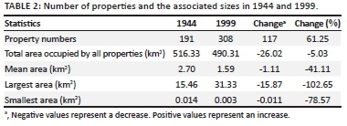
The number of registered properties increased by 61%, with mean property size decreasing by 41% (Table 2).
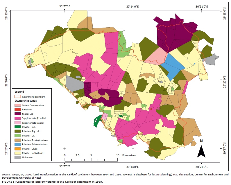
In 1944, land was owned predominantly by private individuals, with private trusts or trustees and state-owned land accounting for the remainder (Table 3; Figure 4). By 1999, however, there were 10 additional categories of ownership (Figure 5). Although private individual ownership remained the largest category, more than half the catchment area had become the property of private businesses (31%) and commercial timber plantation companies (26%).
Implications for biodiversity integrity and hydrological functioning
The loss of grassland to commercial timber plantations and agricultural cropping resulted in the biodiversity integrity and hydrological functioning index deteriorating by 326% and 166%, respectively (Table 4). The relative change in area of other land covers, whether positive (such as an increase in types of natural asset) or negative (such as an increase in the area affected by alien plants), was too small to influence the overall trend. However, the potential future threat of alien plants should be recognised on the basis of their rapid rate of establishment and consequent increase (Table 1). The increase in commercial timber plantations and agricultural cropping has had a pronounced effect on all three of the main components of biodiversity integrity. Landscape composition is changed extensively as a result of the extent of land transformation. Loss of habitat and the proliferating invasion of alien invasive plants, which affect indigenous species negatively, are the result of such transformation. Landscape structure is substantially impaired by transformation, due mostly to commercial timber operations, with an associated negative effect imposed on the extent, porosity, connectivity and geometry of fragments.
Landscape functioning is impaired through altered regimes of fire and grazing, accelerated soil erosion associated with perturbed bio-geochemical processes, including reduced carbon storage, and altered patterns of hydrological functioning. The latter is impaired through impacts on the amount of water and its seasonality of flow, in particular the reduction of base flows during the dry season, which are critical for aquatic biodiversity. In the case of commercial agricultural cropping, water quality (independent of soil erosion) is also severely adversely affected.
Discussion
The nature of land transformation
The most notable land transformation in the Karkloof catchment between 1944 and 1999 is grassland (54%) being lost to commercial timber plantations and agricultural cropping. The area of grassland within the catchment prior to colonial settlement was 334 km2 (Weyer 2000:57, 59). It is estimated that 63% of this had been lost by 1999. Mucina and Rutherford (2006:423) and Jewitt (2011:11) estimate similar losses (50% and 76%, respectively) for the Midlands Mistbelt Grassland, which extends beyond the Karkloof catchment. These estimates are based on the assumed potential for indigenous vegetation if human influence on vegetation was removed and on outlines of remnant vegetation determined for the period 2004-2006 (Mucina & Rutherford 2006:15) and 2008 (Jewitt 2011:11). Estimates for transformation of the Grassland Biome overall are 26% between 1988 and 2000 (Fairbanks et al. 2000:77) and 47% for 1994-1995 (Neke & Du Plessis 2004:472). The loss of grassland in the Karkloof catchment therefore parallels the general trend in the moist eastern portion of the Grassland Biome of South Africa. The remaining grasslands are particularly suitable for commercial timber plantations and agricultural cropping owing to a favourable climate and fertile soils and are therefore highly threatened.
In the 55-year period reviewed in this study, the combined area of forest and woodland did not decrease as it did between 1880 and 1942 (Rycroft 1944:20), but rather increased by 3.02 km2. This increase is ascribed to a number of influences. In 1944, subsistence cultivation was practised in areas within and adjacent to the indigenous forest. When these areas were abandoned, they were re-colonised by indigenous woody vegetation. Expansion of forest and woodland in the eastern portion of South Africa is constrained by fire (Bond, Midgley & Woodward 2003:80). Discussions with land owners revealed that grasslands are burnt less frequently than they were in 1944. A reduction in fire frequency may account for the increase in indigenous woody cover (O'Connor, Puttick & Hoffman 2014:75). In contrast to our findings, Lawes, Macfarlane and Eeley (2004:620) reported a decrease of 5.7% in the area covered by the Karkloof-Balgowan forest archipelago in the midlands of KwaZulu-Natal between 1944 and 1996. This difference may be due to differences in mapping methodologies and category interpretations and a larger study area being used in their study.
The total area of alien invasive plants increased by 7.71 km2 (397%). Alien invasive vegetation poses a major threat to indigenous grassland and forest of eastern South Africa and their associated biodiversity and uses more water than indigenous vegetation (Driver et al. 2012:135). Commercial timber plantations similarly may cause an estimated mean annual stream flow reduction of 3% and a low-flow (dry-season flow) reduction of 8% (Scott, Le Maitre & Fairbanks 1998:193). By 1999, 36% of the total catchment area was under commercial timber plantations (Table 1; Figure 3).
Property size, patterns of ownership and water resource needs
The number of properties increased and the mean size of a property decreased between 1944 and 1999, as similarly recorded by Scotney (1970:185) and Rivers-Moore (1997:35) for adjacent regions. This may be attributed to population growth in South Africa, which increased fourfold in the reviewed period, from 11 415 000 people in 1946 to 43 054 000 in 1999 (Statistics South Africa 2002:8, 10). This may have driven the subdivision of large properties. Furthermore, in 1944 no legislation existed to regulate farm size and it was only with the promulgation of the Subdivision of Agricultural Land Act (Act 70 of 1970) that the indiscriminate subdivision of land was halted. (This act is still in force, but will be repealed once the Draft Preservation and Development of Agricultural Land Framework Bill, as gazetted on the 13 March 2015, is enacted.) Smaller property sizes have implications for reduced biodiversity and hydrological functioning, as farmers are forced to intensify agricultural production to remain economically viable. The aerial photographs of 1996 show clear examples of commercial timber plantations abutting directly onto indigenous forests and commercial cultivation encroaching into wetland areas.
There is a distinct difference between registered farm sizes and managed operational farm sizes. Although mean property size in the catchment generally decreased, the shift from private ownership towards corporate forestry and business entities (agricultural cropping farms and some corporate forestry) suggests that, by 1999, a large proportion of the small properties were farmed as large, consolidated land holdings, with land use and management being influenced accordingly. The economic difficulties of farming small rangeland cattle and agricultural cropping farms that existed prior to 1970 may have precipitated the move towards corporate business ownership of farms. Other economic factors in the late 1970s and early 1980s also had an influence. Worldwide demand for soluble pulp peaked in the 1980s and, in response, two large corporate timber companies began purchasing large tracts of land from as early as 1950, intensifying from 1986 to 1990 (Cairns 2000:7). This is supported by title deed searches, which show ownership transfers taking place in the 1980s. In the 1980s, beef prices were low and many cattle farmers in the catchment sold their land, seeing it as an opportunity for economic survival. The farms sold comprised mostly grassland and at that time no environmental legislation existed to control the potential environmental impacts of development changes and the conversion of natural land cover. Although an environmental clause is included in the Bill of Rights of the Constitution of South Africa, the first specific protective environmental legislation was the Environment Conservation Act 73 of 1989. This has been followed by the National Environmental Management Act (Act 107 of 1998) and the most recent Environmental Impact Assessment regulations of 2014, which afford current protection.
The increase in the number of farm dams in the catchment (Table 1) is directly related to the increase in the number of properties. The increase in dam size can be attributed to the need to optimise or intensify land use on the smaller property sizes. In the adjacent Midmar catchment, reservoirs upstream of the Midmar Dam could reduce median annual streamflow into the dam by 6% (Tarboton & Schulze 1991:229). Increases in the number and area of farm dams in the Karkloof catchment may have a similar effect on water availability in the uMngeni catchment.
Implications for biodiversity integrity and hydrological functioning
Loss of grassland has affected a number of grassland types and parallels similar losses noted elsewhere (e.g. Rivers-Moore 1997:35). Such losses have been sufficient to render some grassland types of conservation concern in South Africa (Mucina & Rutherford 2006:362). Midlands Mistbelt Grassland (53% transformed) is endangered, whereas Ngongoni Veld (39% transformed), Mooi River Highland Grassland (24% transformed) and KwaZulu-Natal Hinterland Thornveld (22% transformed) are classified as vulnerable. In contrast, Drakensberg Foothill Moist Grassland (18% transformed) is classified as least threatened (Mucina & Rutherford 2006:423, 511, 422, 510, 424). Under the National Forest Act (Act 84 of 1998 as amended) forests are afforded protection in South Africa and, consequently, Southern Mistbelt Forest (5% transformed) is classified as least threatened, concordant with the slight increase observed in the Karkloof catchment (Table 1).
The Karkloof catchment is home to a number of red data species (Appendix 1), including 10 plant, 21 bird, two amphibian, one reptile and 11 mammal species (excluding bats). The majority of these are associated with grassland, for which loss of habitat due to land transformation is one of the main threats to their persistence. Six of the ten plant species are grassland species. Of these, five occur in the remaining areas of Midlands Mistbelt Grassland, with three being classified as vulnerable. In contrast, harvesting presents the primary threat to two forest red data plant species, as their habitat has remained secure (Table 1). The vulnerable aquatic species Hydrostachys polymorpha (rivers) and Nerine pancratioides (wetland) are indirectly threatened by loss of grassland to plantation forestry and cropping owing to their sensitivity to altered hydrological functioning.
Although only 12 of the 21 bird species are grassland species, with another two using grassland and forest (Appendix 1), all the bird species use all grassland types in the catchment. The social units of these species use a fairly large home range (Hockey, Dean & Ryan 2005), which for some is greater than 100 km2. Seven of the mammal species rely on grassland (Appendix 1). Oribi antelope, serval and weasel (Friedman & Daly 2004) require large tracts of grassland and are therefore expected to have been adversely affected by the degree of fragmentation in the catchment (compare Figure 2 and 3). The blue swallow has become locally extirpated in this catchment and is threatened with local extinction in South Africa (Wakelin & Hill 2007:252, 254). In contrast, the two amphibian species, as well as the other mammal, reptile and insect species, show fine-grained use of the habitat owing to their smaller body sizes (Appendix 1). These species will therefore likely be less affected by fragmentation, provided the remaining fragments contain the specific habitat features they require. Bird and mammal species whose habitat is forest are unlikely to have been negatively impacted by land transformation, as forests have increased marginally in size and have been spared harvesting in recent decades; however, increases in human density may have escalated indirect pressures.
The decline in biodiversity integrity due to a loss in grassland is probably confounded by deterioration in the botanical composition of grassland for livestock production and a decline in plant species diversity. Grassland dominated by the palatable Themeda triandra has been widely replaced by the unpalatable Aristida junciformis (Camp1997:16; Scotney 1970:154), ostensibly as a consequence of poor grassland management practices earlier, including overstocking, frequent burning, burning early in winter followed immediately by grazing, and continuous selective overgrazing (Acocks 1988:7; Camp 1997:16; Tainton 1999:281). This compositional change has been associated with a loss of forb species (Scott-Shaw & Morris 2015:24).
Conclusion
The Karkloof catchment has been transformed profoundly over half a century. The transformation offers an example of the increasing demand for land at the expense of natural resources. The Midlands Mistbelt Grassland has incurred the most significant loss, resulting in a deterioration of biodiversity integrity and hydrological functioning of the catchment.
Continued pressure to alter patterns of land ownership and, consequently patterns of land use, is expected. This will likely not take place in isolation, but within a global context of climate change, an increasing world population and shortages of land and its products, particularly food and water (Foley et al. 2011:337; World Economic Forum2014:13), and in a changing local sociopolitical and -economic setting.
The ability of the catchment to sustain continued pressure will depend on both government and land owners working towards innovative ways to balance development with environmental conservation.
Acknowledgements
The financial assistance of the Wildlife and Environment Society of Southern Africa and the National Research Foundation is acknowledged. The following individuals and organisations are thanked for their assistance: the land owners of the Karkloof catchment; staff at the Surveyor General's office and the Msunduzi Local Municipality, Pietermaritzburg and K. Cooper, R. Hunt, K. Camp, S. Moodley, D. Scotney, T. Bodington, S. Davies and J. Marshall.
Competing interests
The authors declare that they have no financial or personal relationships that may have inappropriately influenced them in writing this article.
Authors' contributions
V.D.W. (University of KwaZulu-Natal) was the project leader. J.E.G. (South African Environmental Observation Network), T.G.O'C. (South African Environmental Observation Network) and T.R.H. (University of KwaZulu-Natal) were the co-authors. Each co-author contributed their expert knowledge to the research, provided strategic guidance on the direction of the article and edited and commented on the article in preparation for submission. The article is based on original research conducted towards the first author's MSc dissertation (Weyer 2000), supervised by J.E.G. and T.R.H. Although the research was conducted over a decade ago, the data gathered are considered valuable in light of environmental change that has occurred since. The research formed a base to which the co-authors added their area of expertise: J.G. contributed as a specialist grassland ecologist, specifically with regard to the Midlands Mistbelt Grassland; T.R.H. contributed as a geographer and provided knowledge of environmental history and future trends, and T.G.O'C. applied the expert system approach to determine the implications of the land transformation on the biodiversity integrity and hydrological functioning of the catchment.
References
Acocks, J.P.H., 1988, Veld types of South Africa, Botanical Research Institute, Pretoria (Memoirs of the Botanical Survey of South Africa; no. 57). [ Links ]
Bond, W.J., Midgley, G.F. & Woodward, F.I., 2003, 'What controls South African vegetation - climate or fire?', South African Journal of Botany 69(1), 79-91.http://dx.doi.org/10.1016/S0254-6299(15)30362-8 [ Links ]
Cairns, R.I., 2000, 'Outgrower timber schemes in KwaZulu-Natal: Do they build sustainable rural livelihoods and what interventions should be made?', Instruments for sustainable private sector forestry, South Africa series, International Institute for Environment and Development and CSIR-Environmentek, London and Pretoria. [ Links ]
Camp, K.G.T., 1997, 'The Bioresource Groups of KwaZulu-Natal', Cedara Report no. N/A/97/6, KwaZulu-Natal Department of Agriculture, Pietermaritzburg. [ Links ]
Camp, K.G.T., 1998, 'The Bioresource Units of KwaZulu-Natal', Cedara Report no. N/A/95/32, KwaZulu-Natal Department of Agriculture, Pietermaritzburg. [ Links ]
Christopher, A.J., 1994, The atlas of changing South Africa, Routledge, London. [ Links ]
Driver, A., Sink, K.J., Nel, J.N., Holness, S., Van Niekerk, L., Daniels, F. et al., 2012, ''National Biodiversity Assessment 2011: An assessment of South Africa's biodiversity and ecosystems', synthesis report, South African National Biodiversity Institute and Department of Environmental Affairs, Pretoria. [ Links ]
Edwards, E., 1983, 'A broad-scale structural classification of vegetation for practical purposes', Bothalia 14(3&4), 705-712. http://dx.doi.org/10.4102/abc.v14i3/4.1231 [ Links ]
Egoh, B.N., Reyers, B., Rouget, M. & Richardson, D.M., 2011, 'Identifying priority areas for ecosystem service management in South African grasslands', Journal of Environmental Management 92(6), 1642-1650. PMID: 21334134, http://dx.doi.org/10.1016/j.jenvman.2011.01.019 [ Links ]
Ellis, B., 1998, 'The impact of white settlers on the natural environment of Natal, 1845-1870', MA thesis, Dept. of Historical Studies, University of Natal. [ Links ]
Fairbanks, D.H.K., Thompson, M.W., Vink, D.E., Newby, T.S., Van den Berg, H.M. & Everard, D.A., 2000, 'The South African land-cover characteristics database: A synopsis of the landscape', South African Journal of Science 96, 69-82. [ Links ]
Foley, J.A., Ramankutty, N., Brauman, K.A., Cassidy, E.S., Gerber, J.S., Johnston, M. et al., 2011, 'Solutions for a cultivated planet', Nature 478, 337-342. PMID: 21993620,http://dx.doi.org/10.1038/nature10452 [ Links ]
Friedman, Y. & Daly, B., 2004, Red Data book of the Mammals of South Africa: A Conservation Assessment, Endangered Wildlife Trust, Conservation Breeding Specialist Group (SSC/IUCN), Johannesburg. [ Links ]
Hockey, P.A.R., Dean, W.R.J. & Ryan, P.G. (eds.), 2005, Roberts birds of Southern Africa, 7th edn., John Voelcker Bird Book Fund, Cape Town. [ Links ]
Jewitt, D., 2011, 'Conservation targets and status for vegetation types in KwaZulu-Natal', report, Ezemvelo KwaZulu-Natal Wildlife, Pietermaritzburg. [ Links ]
Lawes, M.J., Macfarlane, D.M. & Eeley, H.A.C., 2004, 'Forest landscape pattern in the KwaZulu-Natal midlands, South Africa: 50 years of change or stasis?', Austral Ecology29, 613-623. http://dx.doi.org/10.1111/j.1442-9993.2004.01396.x [ Links ]
Mucina, L. & Rutherford, M.C. (eds.), 2006, The vegetation of South Africa, Lesotho and Swaziland, South African National Biodiversity Institute, Pretoria (Strelitzia series; no. 19). [ Links ]
Neke, K.S. & Du Plessis, M.A., 2004, 'The threat of transformation: Quantifying the vulnerability of grasslands in South Africa', Conservation Biology 18(2), 466-477.http://dx.doi.org/10.1111/j.1523-1739.2004.00157.x [ Links ]
O'Connor, T.G. & Kuyler, P., 2009, 'Impact of land use on the biodiversity integrity of the moist sub-biome of the grassland biome, South Africa', Journal of Environmental Management 90, 384-395. PMID: 18082314, http://dx.doi.org/10.1016/j.jenvman.2007.10.012 [ Links ]
O'Connor, T.G., Puttick, J.R. & Hoffman, M.T., 2014, 'Bush encroachment in southern Africa: Changes and causes', African Journal of Range and Forage Science 31(2), 67-68. http://dx.doi.org/10.2989/10220119.2014.939996 [ Links ]
Rivers-Moore, N.A., 1997, 'The use of a geographical information system to examine changes in land use patterns in the Midmar catchment', MSc dissertation, School of Environment and Development, University of Natal. [ Links ]
Rycroft, H.B., 1944, 'The Karkloof Forest, Natal', Journal of the South African Forestry Association 11, 14-25. [ Links ]
Saaty, T.L., 1990, 'How to make a decision: The analytic hierarchy process', European Journal of Operational Research 48, 9-26. http://dx.doi.org/10.1016/0377-2217(90)90057-I [ Links ]
Scotney, D.M., 1970, 'Soils and land use planning in the Howick extension area', PhD thesis, Dept. of Pasture Science, University of Natal. [ Links ]
Scotney, P., 2010, Sutton Diaries. Pearl Scotney, Port Elizabeth. [ Links ]
Scott, D.F., Le Maitre, D.C. & Fairbanks, D.H.K., 1998, 'Forestry and streamflow reduction in South Africa: A reference system for assessing extent and distribution', Water SA 24(3), 187-200. [ Links ]
Scott-Shaw, R. & Morris, C.D., 2015, 'Grazing depletes forb species diversity in the mesic grasslands of KwaZulu-Natal, South Africa', African Journal of Range and Forage Science 32(1), 21-31. http://dx.doi.org/10.2989/10220119.2014.901418 [ Links ]
Statistics South Africa, 2002, South African Statistics, 2002, Statistics South Africa, Pretoria. [ Links ]
Tainton, N.M. (ed.), 1999, Veld management in South Africa, University of Natal Press, Pietermaritzburg. [ Links ]
Tarboton, K.C. & Schulze, R.E., 1991, 'The "ACRU" modelling system for large catchment water resources management', Hydrology for the water management of large river basins, Proceedings of the Vienna Symposium 201, 219-232. [ Links ]
Trollope, W.S.W., De Ronde, C. & Geldenhuys, C.J., 2004, 'Fire behavior', in J.G. Goldammer & C. de Ronde (eds.), Wildland Fire Management Handbook for Sub-Sahara Africa, pp. 27-59, Global Fire Monitoring Center, Freiburg. [ Links ]
Turner, B.L. & Meyer, W.B., 1994, 'Global land-use and land-cover change: An overview', in B.L. Turner & W.B. Meyer (eds.), Changes in land use and land cover: A global perspective, pp. 3-10, Press Syndicate of the University of Cambridge, Cambridge. [ Links ]
United Nations Environment Programme, 2012, Global Environment Outlook 5. Summary for Policy Makers, United Nations Environment Programme, Nairobi. [ Links ]
Wakelin, J. & Hill, T.R., 2007, 'The impact of land transformation on breeding Blue Swallows Hirundo atrocaerulea Sundevall, in KwaZulu-Natal, South Africa', Journal for Nature Conservation 15, 245-255. http://dx.doi.org/10.1016/j.jnc.2007.05.003 [ Links ]
Weyer, D., 2000, 'Land transformation in the Karkloof catchment between 1944 and 1999: Towards a database for future planning', MSc dissertation, Centre for Environment and Development, University of Natal. [ Links ]
World Economic Forum, 2014, Global Risks 2014, 9th edn., World Economic Forum, Geneva. [ Links ]
World Wildlife Fund South Africa & Council for Scientific and Industrial Research, 2013, 'An introduction to South Africa's water source areas' report ZA 2013, World Wildlife Fund South Africa, Cape Town. [ Links ]
 Correspondence:
Vanessa Weyer
PO Box 1456, Kloof 3640, South Africa
vweyer@global.co.za
Received: 24 Feb. 2015
Accepted: 08 Sept. 2015
Published: 30 Nov. 2015
Appendix 1

References
Barnes, K.N. (ed.), 2000, The Eskom Red Data Book of Birds of South Africa, Lesotho and Swaziland, Birdlife South Africa, Johannesburg. [ Links ]
Ezemvelo KwaZulu-Natal Wildlife, 2014, KwaZulu-Natal Wildlife species database. Ezemvelo KwaZulu-Natal Wildlife, Pietermaritzburg. [ Links ]
Friedman, Y. & Daly, B., 2004, Red Data book of the Mammals of South Africa: A Conservation Assessment, Endangered Wildlife Trust, Conservation Breeding Specialist Group (SSC/IUCN), Johannesburg. [ Links ]
Minter, L.R., Burger, M., Harrison, J.A., Braack, H.H., Bishop, P.J. & Kloepfer, D., 2004, Atlas and Red Data Book of the Frogs of South Africa, Lesotho and Swaziland, Smithsonian Institution, Washington, DC (SI/MAB series; no. 9). [ Links ]
Scott-Shaw, C.R., 1999, Rare and Threatened Plants of KwaZulu-Natal and Neighbouring Regions, KwaZulu-Natal Nature Conservation Service, Pietermaritzburg. [ Links ]

