Serviços Personalizados
Journal

Artigo
 Inglês (pdf)
 Artigo em XML
 Referências do artigo
 Enviar este artigo por email
Indicadores
Links relacionados
-
 Citado por Google
 -
 Similares em Google
Compartilhar

 Permalink
South African Journal of Science
versão On-line ISSN 1996-7489versão impressa ISSN 0038-2353
S. Afr. j. sci. vol.118 no.1-2 Pretoria Jan./Fev. 2022
https://doi.org/10.17159/sajs.2022/5911c
CORRIGENDUM
Corrigendum : Aerial map demonstrates erosional patterns and changing topography at Isimila, Tanzania
[Original article] Bergstrom K, Lawrence AB, Pelissero AJ, Hammond LJ, Maro E, Bunn HT, Musiba CM. Aerial map demonstrates erosional patterns and changing topography at Isimila, Tanzania. S Afr J Sci. 2019;115(7/8), Art. #5911. https://doi.org/10.17159/sajs.2019/5911
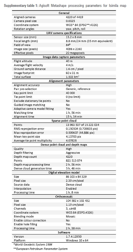
Due to an error in the reference plane, the elevation range shown for the digital elevation model (DEM) in Figure 5a (Page 3) is incorrect. The correct elevation range is 1629.41-1679.64 m. The DEM and orthomosaic map data were reprocessed using Agisoft Metashape 1.7.4. Processing parameters for the corrected DEM and orthomosaic differ slightly from those in Supplementary table 1 as a result of correcting the reference plane and differences in technical specifications of the computers used to process data. The corrected DEM, orthomosaic, and processing parameters are available for download at: https://doi.org/10.5281/zenodo.4592344. The corrected Figure 5 and Supplementary table 1 appear below. The error does not affect the interpretation of data in the original article.
We thank Rebecca Bateman and Richard Bates for bringing the error to our attention and for sharing their data, as well as Pastory Bushozi and Philbert Katto for sharing their field data.